Short analysis of warm front
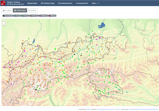
The warm front forecast by the ZAMG Weather Service for 29.12-30.12 brought widespread 15mm to 50mm of precipitation to North Tirol and northern East Tirol. The focal point of precipitation lay in western and northwestern regions. Initially the snowfall continued for longer than expected, then the snowfall level swiftly ascended. Generally there was rainfall up to 2300-2500 m. For a short time the upper limit was even higher, e.g in the Arlberg region where it rained as far up as 2800 m.
 |
| Distribution of precipitation in Tirol on 29-30.12.2021 - less precipitation than expected in the central part of North Tirol and in northern East Tirol. |
The warm front was accompanied by storm-strength winds in the mountains. It is much too warm for this juncture of the season.
As a result of the warm front, heavy fog formed at ground level on 30-31.12.
| Fogbanks over Inn Valley, viewed from the Northern Massif. |
High avalanche activity for a short period
The greatest amount of avalanche activity took the form of wet, small-to-medium loose snow avalanches. Subsequently, glide-snow avalanches followed. Then, particularly at high altitudes, slab avalanches. The last category was also triggered by explosives. Good success with artificial triggerings, large-sized avalanches were unleashed in ski areas in western regions.
 |
| Arrows point to loose snow avalanches in extremely steep terrain which triggered naturally during the period of rainfall. Kalkkögel. Northern Stubai Alps (photo: 30.12.2021) |
 |
| Utterly windblown: Pimigspitze in the Ausserfern. Loose-snow and glide-snow slides and avalanches. (photo: 30.12.2021) |
 |
| Medium-sized slab avalanches from artificial triggerings, Wilde Grube, glacier ski area of Stubai Glacier (photo: 30.12.2021) |
 |
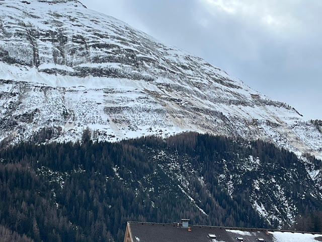
| Loose-snow and glide-snow avalanches below Dawinspitze in eastern Lechtal Alps (photo: 31.12.2021) |
 |
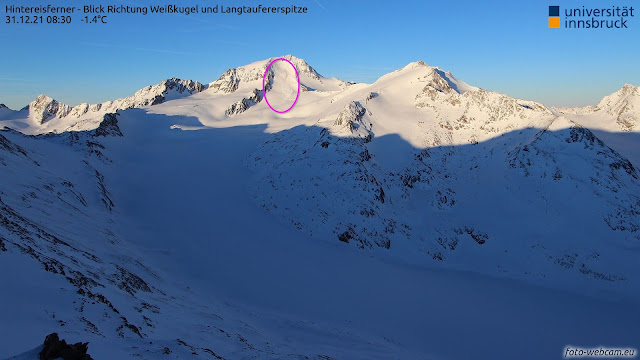
| Encircled is a large naturally triggered slab avalanche which released from a weak layer on glacial ice. Weisskugel. |
Springtime conditions with poor snow quality
Conditions remind us of spring: a wet snowpack at low and intermediate altitudes, at high altitudes the snowpack has a melt-freeze crust due to nocturnal outgoing (longwave) radiation on 30-31.12. Snow quality is poor. In fact, skiing is currently best on the public ski slopes or in much used outying terrain.
 |
| Rain grooves in the snowpack surface. Obergurgl (photo: 30.12.2021) |
 |
| “Gatsch” (local argo for slush) at 1600 m (photo: 30.12.2021) |
The difference from spring lies in the not-intensive solar radiation. In addition, the quite dry air masses impede daily moistening of the snowpack. For that reason, as well as due to the high avalanche activity, we expect only isolated moist slides, most likely as glide snow, on very steep sunny slopes.
Further developments
Further developments
Currently it appears that avalanche danger will recede further, while snow quality will remain poor. Avalanche prone locations where slab avalanches can be triggered occur mostly above 2300 m, frequently on very steep shady slopes in in ridgeine terrain at high altitudes. What can be triggered: the recently generated snowdrifts. In very isolated cases, triggerings of slab avalanches are possible down to deeper layers by large additional loading also in extremely steep terrain where snow is shallow, above 2300 m, particularly in NW-N-NE aspects. Conditions in the furthermost eastern regions and in southern East Tirol are more favourable.
It will remain warm to begin with. At the beginning of the new year it will become wetter. As of Wednesday, snowfall is again expected down to low lying areas.
We wish all of you a smooth slide into the New Year and a happy-and-healthy year in 2022!
