Thursday 18 May 2023

Avalanches expected due to improved weather and higher temperatures

 In a nutshell...


An overly cool month of May which was full of precipitation has endured until today, 17.05. Now we can expect improved weather with steadily rising temperatures, although variable conditions will continue. We expect numerous avalanches during the next few days. Caution is urged also on very steep to extremely steep high-altitude north-facing slopes known to be starting zones. There, avalanches can plummet down to the green areas. For a brief spell we’ll also be confronted by numerous loose-snow avalanches in extremely steep terrain.


Frische Lawinenablagerung im Ködnitztal im Nahbereich eines Weges. (Foto: 17.05.2023)
Fresh avalanche deposit in Ködnitztal, near a road. (photo: 17.05.2023)


Still lots of snow at high altitudes

Due to more than ample precipitation in April and May there is still lots of snow at high altitudes, whereas at low and intermediate altitudes, barring brief interruptions during cold snaps, the slopes are becoming bare. 

Analyse der Gesamtschneehöhenverteilung in Tirol vom 17.05.2023
Analysis of overall snow distribution in Tirol on 17.05.2023


Despite numerous releases, still lots of avalanche potential

Since the end of April we have experienced a period rich in avalanches. Apart from slab releases we have observed many loose-snow avalanches and isolated glide-snow avalanches. Slab avalanches triggered both because of additional loading atop the large amounts of fresh fallen snow and also due to the snowpack becoming wetter and wetter, weakening the ground-level layers. During the short interims with better weather following snowfall, furthermore, numerous loose-snow avalanches triggered in extremely steep terrain. Glide-snow avalanches also slid over the smooth ground in zones where there was fresh snowfall.

The biggest danger, comparatively speaking, continues to be slab avalanches from high-altitude starting zones. This applies especially to very steep to extremely steep north-facing slopes above about 2600m. In high alpine regions (above 3000m) this will also strike sunny slopes to an increasing extent. Below such starting zones, particularly near long gullies, bowls or small valleys, avalanches can plummet all the way to the valley floor, where the ground is now bare of snow. Therefore, exercise high caution.


Immer wieder zu beobachten: Durch den Impuls von Lockerschneelawinen lösten sich in Folge Schneebrettlawinen. Region Kühtai (Foto: 13.05.2023)
Repeatedly observed: through the impulse of a loose-snow avalanche, a slab avalanche gets triggered. Region Kühtai (photo: 13.05.2023)


Unmittelbar mit den ersten Sonnenstrahlen hohe Lawinenaktivität. Auch an diesem Foto erkennt man sowohl Lockerschnee-, als auch Schneebrettlawinen. Östliche Deferegger Alpen (Foto: 12.05.2023)
Immediately with the first sunshine, high avalanche activity. Also in this photo, both loose-snow and slab avalanches can be observed. Eastern Deferegger Alps (photo: 12.05.2023)


Auf dem Glasdach im Vordergrund erkennt man Risse, aber auch bereits einen Bereich, wo Schnee abgeglitten ist (Foto: 11.05.2023)
Cracks are visible in the glass roof in foreground, also an area where snow glided away. (photo: 11.05.2023)


Vergleichsfoto 10 Minuten später...
This is what it looked like 10 minutes later...


Snowfall down to intermediate altitudes

Starting on 11 May there was repeated snowfall down to intermediate altitudes, creating problems on pass roads with suddenly wintery conditions, e.g. Arlberg Pass.


Winterlich im Serleskamm auf ca. 1600m (Foto: 11.05.2023)
Downright wintery in the Serleskamm region at about 1600m (photo: 11.05.2023)


Monatsrückblick: Auffallend der häufige Niederschlag, der zu einem Schneehöhenanstieg in der Höhe geführt hat. Für die Jahreszeit häufig zu kalt.
The month in review: frequent precipitation raised snow depths at high altitudes. Temperatures too low for this juncture of the season.


Ähnliches Bild im hinteren Zillertal - viel Niederschlag, wenig sonnige Tage, kalt
A similar picture in rear Zillertal: lots of precipitation, few sunny days, cold.


The snowpack

There is not much information currently available about the snowpack in open terrain. What we do know: recent snowfall was often riddled with graupel. For a brief time this could generate a weak layer near freshly generated snowdrift accumulations at high altitudes; or else near-surface metamorphosis due to quickly changing temperatures (danger pattern Cold on Warm - dp.4). This will be only a temporary problem.

What is most significant is the anticipated, swift moistening of the surface layer, or the snowpack becoming thoroughly wet. From that alone, high avalanche activity will quickly result. The impulse of these loose-snow avalanches could lead to slab avalanches triggering, just as in recent weeks.

Due to steadily rising temperatures during the next few days we expect increasing water seepage into the deeper layers of the snowpack at high altitudes. That will resut in ground-level layers weakening (if that was not already the case). This will lead to naturally triggered slab avalanches, particularly above 2600m.  


Temperaturanstieg während der kommenden Tage. Folglich wird die Schneedecke neuerlich  feucht bzw. nass.
Rising temperatures during the next few days, thereby making the snowpack wetter.


The outlook, in short

The potential danger of slab avalanches is heading to higher altitudes. Plan your backcountry tour so that it can quickly adapt to small weather changes, which in springtime have large consequences. That can go both ways: a change for the better and a change for the worse.
Wednesday 10 May 2023

Over 50 cm of fresh snow regionally makes avalanche danger surge – Caution: naturally triggered releases!

 In a nutshell


It seems as if a warm winter with too little snow just woke up and wanted to make up for lost time. This evening, on 09.05.2023, a cold front is arriving which will bring lots of fresh snow to the mountains. Avalanche danger will increase. Frequent naturally triggered releases can be expected over the coming days.


Some fresh snow in the mountains
According to GeoSphere Austria, 40-60mm of precipitation can be expected over far-reaching areas by Thursday, 12.05, locally up to about 90mm. In the mountains that means generally 50cm of fresh snow, significantly more from place to place. The zero-degree level is expected to descend swiftly from 2900m down to 2200m to begin with. Between Wednesday, 10.05, and Thursday, 11.05, the zero-degree level will reach its lowermost altitude at about 1800m.


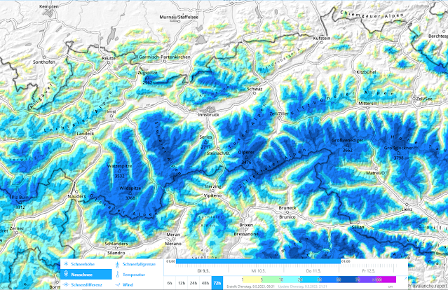
72h Neuschneeprognose 09.05.-11.05.2023
72-hr fresh snowfall forecast 09.05.-11.05.2023


Die kommenden Tage wird es nass... Wind ist überschaubar. Während des Niederschlags sinkende Schneefallgrenze.
The next few days will be wet, with light winds. During the precipitation, the snowfall level will descend.


Schneefallgrenze für 11.05. 05:00 Uhr
Snowfall level for 11.05. at 05:00 a.m.


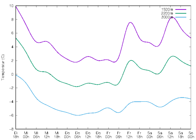
Temperaturentwicklung in verschiedenen Höhenniveaus
Temperature development at various altitudes


Increase in avalanche danger including naturally triggered avalanches

Avalanche activity over the last few days

The last few days - just as predicted in our last  Blog  - were marked by naturally triggered releases. These were large, in isolated cases also very large slab avalanches which sometimes plummeted down to low altitudes. Most of them which were observed and reported triggered on north-facing slopes at 2600-2900m. On sunny slopes they occurred nearly exclusively in high alpine terrain (above 3000m). The cause of the releases was progressive wetness, and thereby weakening, of the weak layers near ground level which formed in early winter. The triggering impulse came frequently from loose-snow avalanches, in isolated cases from breaking cornices.


Oberhalb der roten Pfeile lösten sich Lockerschneelawinen im felsdurchsetzten Gelände. Die Zusatzbelastung einer dieser Lockerschneelawinen dürfte die Ursache der Schneebrettauslösung gewesen sein. Defereggental (Foto: 06.05.2023)
Above the red arrows loose-snow avalanches triggered in rocky terrain. The additional load from one of these loose-snow avalanches was probably the cause of the slab avalanche triggering. Defereggental
(photo: 06.05.2023)


Schneebrettauslösung vermutlich durch einen kleinen Wechtenbruch - Stubaier Gletscher (Foto: 05.05.2023)
Slab avalanche triggering, probably from a small cornice breaking - Stubai Glacier (photo: 05.05.2023)


Lawinenabgang in den Nördlichen Zillertaler Alpen vom 08.05.2023. Der im Bereich des Lawinenkegels vorbeiziehende Wanderweg wurde vorsorglich gesperrt. (Foto: 08.05.2023)
Avalanche triggering in northern Zillertal Alps on 08.05.2023. The hiking trail which brushes the plummet path was closed as a precautionary measure. (photo: 08.05.2023)


Avalanches over the next few days

During the next few days we expect a relatively high frequency of avalanche activity. In the high altitude zones where snowfall is heaviest, particularly on north-facing slopes above 2600m and in other aspects at high alpine altitudes, the additional load of the fresh snow will cause avalanches to trigger naturally. Just as in recent days, these releases can plummet down to green zones.

During interims in precipitation – when there is (diffuse) radiation or when temperatures rise after snowfall – numerous loose-snow avalanches will trigger on extremely steep slopes. Here too, the impulse of loose-snow avalanches can trigger slab avalanches.

Wherever there is ample snowfall on steep grass-covered slopes, glide-snow slides and glide-snow avalanches can be expected for a short time.


A serious avalanche situation - Heed avalanche closure zones!

The situation will be quite serious over the next few days. Whoever is out in open terrain needs to be aware of the heightened risks of avalanches. Please heed the avalanche closure zones on hiking trails, forest roads, etc. As the photo above demonstrates, they are more than justified.

Friday 5 May 2023

Following good firn snow conditions, new burst of warmth + rainfall

In a nutshell...


After two days of flawless firn snow conditions and a daytime cycle of wet-snow avalanche danger, the weather is again becoming instable. On Saturday, 06.05, it will be a bit cooler, sunshine and clouds will alternate, showers and thunderstorms can pass through. On Sunday, 07.05, it will turn warm again, with a mixture of sunshine, clouds and thunderstorm showers. Thus, avalanche danger will vary greatly from region to region. Danger zones for wet-snow avalanches occur especially on steep shady slopes above 2600m wherever the snow is rather shallow. Where the reserves of cold are nearly used up inside the snowpack and there are faceted weak layers, naturally triggered avalanches are possible.

Review of recent days, outlook for the weekend
The snowpack was able to cool during the last few nights, a melt-freeze crust formed which was capable of bearing loads, it then softened up during the daytime all the way up to high alpine regions, depending on aspect, creating perfect firn-snow conditions.

Geisslehnscharte on 04.05: the long ascent was rewarded by perfect firn snow.

The small amount of information regarding snowpack conditions from profiles and snowpack models show that above 2600m on shady slopes, there are still reserves of cold in the snow cover. The deeper the snowpack is, the greater they are.
 
Snow profile from 04.05 on Geisslehnscharte: temperature variations inside the snowpack show that there are still reserves of cold. Snow depths are above average here.

At low altitudes and wherever there is less snow on the ground, even high-altitude shady slopes became wet for the first time this season. As we reported in the last blog, activity was at its highest on the weekend prior to 1 May. Also in the last few days, impressive photos have shown us the avalanches which released in this period.
 
Seen through the telescope: wet-snow avalanches at summit level, as seen here on Ochsenbug in East Tirol.


Large naturally triggered avalanche on the Seespitze, Schlick, Stubai Alps, presumably from Saturday, 29.04 or Sunday, 30.04.


Finally some good firn snow! But unfortunately it’s already passed. Due to weather developments in coming days, firn snow formation doesn’t stand a chance.

Following a night of clear skies on 3-4.05, the surface temperatures sank to -10°C. Due to higher daytime temperatures, it ascended noticeably (red arrow) and wasn’t above  to cool down as much at night on 5 May due to the high relative humidity.

A different weather station, an identical picture: following a night of clear skies on 3-4 May, the surface temperature descended to -10°C. Due to daytime warmth it rose visibly (red arrow) and wasn’t above  to cool down as much at night on 5 May due to the high relative humidity.

Reduced nocturnal outgoing radiation, thunderstorms, higher daytime temperatures are again weakening the snowpack, especially where it wasn’t yet thoroughly wet. Snow quality and snowpack stability will be poor to very poor. Danger zones for wet-snow avalanches occur esp. on steep shady slopes above 2600m where the snow is shallow. Where the temperature reserves inside ths snowpack are used up and there are faceted layers, naturally triggered avalanches will be possible.

To finish up, two photos of the snowpack:

Whereas in glacer zones there is still sufficient snow for winter sports...

...in others it’s hard to find the way down to the valley.

Wednesday 3 May 2023

May is just like April – Weak snowpack at high altitudes

 In a nutshell...


Even if we are already in the month of May, April-weather persists. The variable conditions of recent days have further weakened the snowpack. Rain, high temperatures and repeated bouts of rainfall or fresh snow have weakend it especially on shady slopes above 2300 m. On Saturday, 29.04, there was heightened avalanche activity, including involving persons. On Thursday and Friday, 04-05.05 it is expected to reach early summer temperatures. Avalanche danger is then subject to an intense daytime cycle. Backcountry tours should be brought to a close early in the day.
 
Large-sized avalanche on 29.04 involving persons, below eastern Seespitze in the Stubai Alps, 2950m, north-facing slope.

Review of last week
Recent weather was marked by various rounds of precipitation. On Friday, 28.04 there was precipitation throughout Tirol, including significant amounts of rainfall and fresh snow.

48-hr amounts of precipitation, measured on Friday, 28.04

Over widespread areas there was 30 mm of rain, above 2500m it fell as snow. Particularly in western and the furthermost northeastern regions of Tirol, large amounts of precipitation were registered. The snowfall level initially lay at 2000 m, then ascended to 2500 m.
 
Three bouts of precipitation with varying snowfall levels measured at Pitztal Glacier weather station and compared with reports from our observers.

After the end of the precipitation, it was partly sunny on Saturday, 29.04, and immediately quite mild. The zero-degree level lay at 3000 m. The danger of wet-snow avalanches increased significantly and was, due to the rainfall, warmth and lack of nocturnal outgoing radiation, the main danger during the following days.

On the evening of 01.05, precipitation struck again. On 02.05 there was rainfall at low altitudes all day long. Above 2300 m there was an additional few cm of fresh snow registered. Winds were light to moderate.

Avalanche activity from last weekend (29.04. to 01.05.)
As a result of rainfall and higher daytime temperatures, especially along the Main Alpine Ridge, many wet-snow avalanches released, including large-sized ones. As we said in our last Blog, three ground rules are the prerequisites: high altitude rainfall level and intensity of rainfall; warmth; and the first time dry layers of the snowpack become thoroughly wet. Avalanches can then grow to impressive size for winter sports enthusiasts. Headquarters Tirol received reports of ten avalanches which involved persons.  In three cases, we were able to confirm the involvement of persons. All avalanches ended without grave results.

Typical picture of Saturday, 29.04. Due to a thoroughly wet snowpack, avalanches sweep away a slab nearly to ground level...

...and thereby attain impressively large size.

Also in East Tirol there were avalanches, such as here on Vorderen Plattenkogel.

Large-sized avalanche on Hohe Zahn in the Stubai Alps. Wet-snow avalanches can often take a plummet path which is unpredictable. Deposits of snow can be rather massive.

Outlook for the coming days

On Wednesday night (03-04.05) skies will be predominantly clear, the snowpack surface will have sufficient outgoing longwave radiation, a melt-freeze crust capable of bearing loads will be able to form. Due to the solar radiation which is already quite intensive and the high daytime temperatures, the crust will rapidly soften up and the process of wetness will continue. Especially where the snowpack is not yet isotherm and thoroughly wet, we expect increased avalanche activity, particularly on very steep, shady slopes at 2600-3000 m.

Smart planning and savvy time allotment
As the spring progresses, weather conditions, snowpack and, thus, avalanche risks can vary enormously from place to place. For that reason it is even more important to evaluate the conditions on-site with great precision and be flexible in planning backcountry tours so that you can react to conditions on the spot. 

Over the next few days, your backcountry touring goals need to have exact time allotment. As described above, we expect an intense and a fast-moving daytime danger cycle of avalanche risks.

At high altitudes, the danger zones occur mostly on very steep shady slopes in the near-surface weak layers (persistent weak layer due to cold on warm since the end of March). This affects particularly the altitude band of 2600-3000 m. In high alpine regions, i.e. above 3000 m, isolated sunny slopes are also affected by this phenomenon.

Whoever does not venture up to such altitudes will find quite good conditions on the (now closed) ski pistes.

“What’s up, bro?” Nowadays, backcountry tourers can be looked at somewhat critically.

Friday 28 April 2023

Mostly moderate avalanche danger – Rain + warmth weakening the snowpack

 In a nutshell...


April weather conditions persist. A warm front today and tomorrow (28-29.04) is bringing rain up to 2300 m, most of which (30mm) will be north of the Inn. At high altitudes, strong westerly winds will be blowing. On the weekend, dispersed clouds, more pleasant weather before on 1 May slight foehn-impact and during the daytime more rainfall can be expected. Rain and warmth will push the wet-snow problem to the forefront next week.


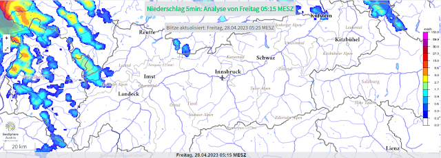
Niederschlag ist im Anmarsch und wird sich heute, am 28.04. über ganz Tirol ausbreiten.
Precipitation is coming, will spread throughout Tirol today, 28 April.


Rain + warmth weakening the snowpack

The snowpack was thoroughly moistened several times this winter: on steep sunny slopes up to high alpine zones, on shady slopes up to 2500 m. This is decisive in assessing avalanche danger resulting from rainfall. If the rainfall level is at 2300 m (as forecast), then the near-surface layers (of recently fallen fresh snow) will be weakened.


Der Neuschnee vom 24.04. und 25.04.2023. Wassereintrag kann diesen (inzwischen vielerorts gesetzten) Schnee wieder schwächen.
Fresh snowfall from 24-25 April. Water seepage can weaken the snow (which had settled) in many places.


Oberflächennahe Lockerschneelawinen werden mit dem Regen vermehrt zu beobachten sein. (Foto: 25.04.2023)
Near-surface loose-snow avalanches will become more frequent due to rain. (photo: 25.04.2023)

If the rainfall level is further up, heightened proneness to triggering is also indicated on shady slopes. Both rainfall intensity and nocturnal outgoing longwave radiation play a role in the snowpack from 27-28.04. Wherever nighttime skies were clear for longer, the water seepage is delayed due to a thin melt-freeze crust forming.


Anfangs noch klare Nacht...
Initially clear nighttime skies...


In den Morgenstunden bedeckt.
In early morning: overcast.

Above all else, naturally triggered slab avalanches cannot be ruled out on shady slopes if the snowpack is thoroughly wet. Fractures in near-surface weak layers (formed since the end of March) can lead to fractures of more deeply embedded layers in the snowpack.


Short review of the last week

The week was marked by the month: April. Following very warm days last weekend (22-23.04) there was a cooler phase. In the meantime, temperatures have risen again. A warm front is now bringing rain.


Hohe Luftfeuchtigkeit und warme Temperaturen am 23.04. - Golzentipp - Südliches Osttirol
High moisture in the atmosphere and warm temperatures on 23.04 - Golzentipp - southern East Tirol


Deteriorating conditions on 23.04.2023


Schneefall in der Weißkugelgruppe (Foto: 25.04.2023)
Snowfall in the Weisskugel Massif (photo: 25.04.2023)


Recht gute Bedingungen in der Silvretta (Foto: 27.04.2023)
Quite good conditions in the Silvretta (photo: 27.04.2023)


Wochenrückblick: Anfangs warm, dann mit Schneefall kälter werdend, die Schneedecke stabilisierend, dann wieder wechselhaftes, wärmer werdendes Aprilwetter. In der Höhe recht windig. Die Schneeoberfläche kühlte in der vergangenen Nacht etwas aus.
Week review: initially warm, then snowfall and dropping temperatures, the snowpack stabilizes, then again highly variable conditions, and again it turns warm. At high altitudes, quite windy. The snowpack surface cools somewhat during the night.


Wechten als drohende Gefahr, auch als mögliche große Zusatzbelastung auf die Schneedecke. Silvretta. (Foto: 27.04.2023)
Cornices are a threat to the snowpack with large additional loading. Silvretta (photo: 27.04.2023)


Auch wenn die Spaltenüberdeckung im April besser wurde bleiben Spalten eine nicht zu unterschätzende Gefahr (Foto: 25.04.2023)
Even if the crevices were covered in April, they remain a big threat. (photo: 25.04.2023)


Good tour planning and time organisation

...both help. Choose a suitable touring goal. If it is not too high, the conditions on ski pistes are currently quite good. 

At high altitudes the danger zones are mostly on very steep shady slopes due to near-surface weak layers (persistent weak layer due to cold-on-warm since the end of March). Particularly between 2600 and 3000m this is the case. In high alpine regions (above 3000m) isolated spots also on sunny slopes.

After snowfall, loose-snow avalanches in extremely steep terrain, in high alpine regions esp. near ridgelines, high attentiveness to fresh snow is required.


24h-Neuschneeprognose. Bis zumindest mittlere Lagen hinauf fällt Regen (der hier natürlich nicht aufscheint.)
24-hr fresh snow forecast. Up to intermediate altitudes, rainfall (not visible in this graph).

Friday 21 April 2023

Highly variable April weather leads to quickly shifting avalanche dangers

 In a nutshell...


April is quite justly famous for its caprices with the weather. This is having rapid effects on avalanche dangers. Due to an expected surge in temperatures tomorrow (Saturday, 22.04) the danger will increase during the course of the day. More frequent naturally triggered avalanches will be the result. Savvy tour planning and exercising personal restraint are crucial.


Following snowfall, increasingly wet and weak snowpack

Following a striking springtime injection at the end of March and the coldish phase which came in its wake, we now adjust our sights to the snowpack moistening or becoming thoroughly wet. Current snowpack analysis shows temperature reserves inside the snow cover to be nearly used up, even on shady slopes below 2700m. That means, the snow temperature is already 0° or pretty close to it. Warm temperatures, high air moisture (convective cloud build-up during the day) and (diffuse) solar radiation lead to the snowpack swiftly becoming thoroughly wet. Water seepage weakens it further. As of then, likelihood of slab avalanches being triggered by winter sports enthusiasts rises, as does likelihood of naturally triggered avalanches (slab, loose-snow, glide-snow).


Die rote Linie zeigt die Schneetemperatur an. Diese lag am 19.04. auf 2650m in einem 28° steilen NO-Hang bereits nahe bei 0°C bzw. erreichte bereits 0°C. Mögliche Schwachschichten für Schneebrettlawinen finden sich im Nahbereich der Ende März gebildeten Schmelzkruste bzw. in bodennahen, lockeren Schichten.
The red line shows snow temperature. On 19 April at 2650m it lay at nearly 0° on a 28°-steep NE-facing slope. Potential weak layers for slab avalanches occur near the melt-freeze crust which formed at the end of March or in loose layers near ground level.


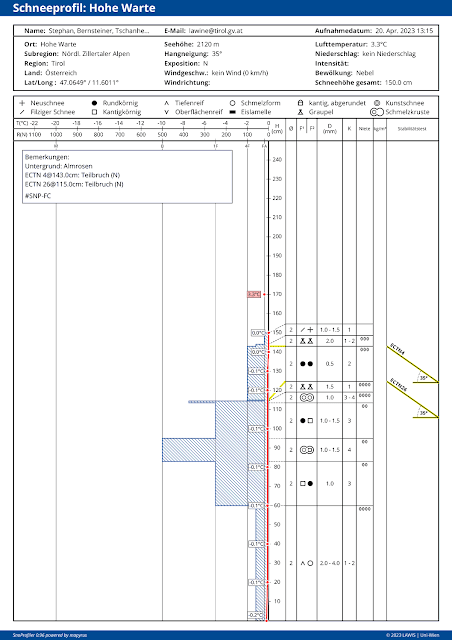
Bei dem gestern, am 20.04. aufgenommenen Profil auf 2120m in einem 35° steilen Nordhang in den Nördlichen Zillertaler Alpen ist die Schneedecke durchgehend isotherm.
In this snow profile taken yesterday (20.04) at 2120m on a 35°-steep north-facing slope in the northern Zillertal Alps, the snowpack is thoroughly isotherm.


Die zunehmende Durchfeuchtung der Schneedecke erkennt man beispielhaft auch sehr gut an der Grafik der Wetterstation Mosesgipfel in den Östlichen Deferegger Alpen. In der zweiten Grafik von oben wird die Schneeoberflächentemperatur (graue Linie) von Tag zu Tag flacher. Auch nähert sich der Taupunkt (blaue Linie) der 0°-Linie. Aktuell ist es vor Ort bewölkt. Die Luftfeuchtigkeit beträgt 100%. Die Erwärmung und zunehmende Schmelze macht sich parallel auch bei der Abnahme der Schneehöhe bemerkbar.
The increasing wetness of the snowpack is visible in exemplary fashion in this graph from Mosesgipfel weather station in the eastern Deferegger Alps. In the graph second from the top, snowpack surface temperature (gray line) flattens out more each day. Also, the thawing point (blue line) gets closer to the 0°-line. Currently, skies on-site are cloudy. Moisture of the air is 100%. Higher temperatures and increasing meltage are notable, alongside lessening snow depths.


Heightened avalanche activity - for a short time, large-sized avalanches are possible

As mentioned, we currently expect heightened avalanche activity. In the areas where recent snowfall has been heaviest (near the border to South Tirol in the Main Alpine Ridge) numerous loose-snow avalanches can be expected today (21.04). Due to the additional loading from loose-snow avalanches, in their wake slab avalanches could also be triggered near persistent weak layers at mid-level in the snow cover and at ground level. Thereby, large-sized releases could be generated.


48h Neuschneeprognose vom 20.04.2023
48-hr fresh snow forecast from 20.04.2023


24h-Niederschlagsverteilung (Stand: 21.04.2023 07:20 Uhr)
24-hr precipitation distribution (cut-off date: 21.04.2023 7:20 am)


Impressions from last week


Blick vom Hochstein oberhalb von Lienz ins Lienzer Becken (Foto: 14.04.2023)
View from Hochstein above Lienz, in the Lienz basin (photo: 14.04.2023)


Schneebrettauslösung von Wintersportlern im Bereich des Flimjochs, Grenzgebiet Samnaungruppe / Schweiz; Nord 2700m 35° (Foto: 18.04.2023)
A slab avalanche triggered by a winter sports enthusiast near Flimjoch, bordering on the Samnaun Massif in Switzerland; north 2700m 35° (photo: 18.04.2023) 


Graupel - ein in letzter Zeit häufiger Begleiter von Schneefällen (Foto: 19.04.2023)
Graupel - often accompanying snowfall in the last few weeks (photo: 19.04.2023)


Visible on the right side of the persons is a recently triggered loose-snow avalanche. Gurgler Massif
(photo: 19.04.2023)


What’s on the horizon?

On Sunday, 23.04, a cold front will again bring precipitation. Weather conditions will remain instable. The forecasts are still uncertain. Precipitation in showers is anticipated, which means we’ll have heightened potential of graupel accompanying the snowfall. Wherever snowfall is intensive graupel can quickly form a weak layer for slab avalanches to trigger from. The situation demands meticulous backcountry tour planning. Apart from frequently poor snow quality, it is also necessary to keep an eye on heightened avalanche risks in open terrain. The only place where conditions tend to be better is at very high altitudes where the warmth has less of an effect.

Thursday 13 April 2023

Considerable avalanche danger due to heavy snowfall in places

 In a nutshell...


A cold front is delivering fresh snow down to intermediate altitudes. At elevated altitudes conditions for a short time will be like in deep winter. Simultaneously, avalanche danger in many places has increased to considerable. We expect higher likelihood of slab avalanches getting triggered by winter sports enthusiasts, and also increasingly frequent natural triggerings.


Fresh snow plus wind:  ratcheting up avalanche danger

Currently (13.04.2023) it is snowing in far-reaching parts of Tirol. Up to now there has been up to 40 cm of fresh snow registered from place to place, most in the western and eastern regions of North Tirol, also in southern and furthermost northern East Tirol.


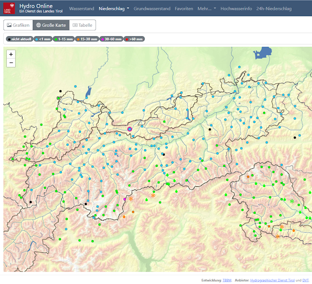
Map by Hydro Online shows overall 48-hr snowfall (time: 4:00 pm on 13.04.2023)


48h Neuschneeprognose 13.04.-14.04.2023
48-hr fresh snow forecast 13.04.-14.04.2023


Niederschlags- und Windprognose für eine der niederschlagsreichsten Regionen. Der Wind legt morgen am Freitag, 14.04. zu.
Precipitation / wind forecast for a heavy-precipitation region. Winds will intensify tomorrow, Friday, 14.04.


Slab avalanches, loose-snow avalanches, glide-snow avalanches

Lots of fresh snowfall in late spring always means that increased avalanche activity can be expected, at latest, as of the first bright intervals, in other words, when diffuse radiation begins. These will be primarily loose-snow avalanches in extremely steep terrain. In the regions where snowfall has been heaviest they can be of medium size. Besides that, heightened likelihood of slab avalanches can also be expected. Slab avalanches can currently be unleashed by several different causes:
  • The winds (expected to intensify tomorrow, 14.04) transports the fresh snow, generates fresh snowdrift accumulations. The frequency and proneness to triggering of fresh drifts increase with ascending altitude.
  • In regions where precipitation is heavy but winds are light, near-surface loose snow can be bonded by diffuse radiation. Thereby, a slab forms near the surface. The still loose, cold snow beneath it serves as the necessary weak layer for the slab, active for a brief spell.
  • In regions where snowfall has been especially heavy, slab avalanches can break through the snowpack in isolated cases, likeliest at mid-level. This will occur most frequently above 2600m. (Weak layer due to cold on warm, see  Blog. Fractures down to ground level can’t be ruled out.

Das Archivbild vom 06.04.2023 zeigt einen großen Lawinenabgang in einem extrem steilen O-NO-Hang auf etwa 3000m in der Region Kühtai-Geigenkamm. Vereinzelt sind in den besonders neuschneereichen ähnliche, spontane Lawinenabgänge vorstellbar.
This photo dating from 06.04.2023 shows a large-sized avalanche on an extremely steep E/NE facing slope at about 3000m in the Kühtai-Geigenkamm region. In regions where snowfall has been heaviest, similar naturally triggered avalanches are possible in isolated cases.


In addition, glide-snow slides and glide-snow avalanches will also be observed, particularly in regions where snowfall has been heaviest. This is most likely to occur on steep, grass-covered slopes where prior to this bout of precipitation the ground was bare.


For a short time: treacherous conditions. Then a rapidly improving situation in view. Thereafter, future developments still uncertain.

We assume a highly treacherous situation for winter sports enthusiasts for a brief spell. In southern East Tirol where weather conditions will improve more swiftly, the fact is that on the first day of fine weather (even if only a short spell of it) the risks in backcountry are especially high. It is also characteristic of the season that the near-surface snowpack rapidly improves and stabilizes. Due to April weather caprices, we still need to await coming conditions before we say anything more.