Friday 31 December 2021

New Year’s Eve update on avalanche situation: gradually diminishing avalanche danger

Warm front led to increased avalanches


Short analysis of warm front

The warm front forecast by the ZAMG Weather Service for 29.12-30.12 brought widespread 15mm to 50mm of precipitation to North Tirol and northern East Tirol. The focal point of precipitation lay in western and northwestern regions. Initially the snowfall continued for longer than expected, then the snowfall level swiftly ascended. Generally there was rainfall up to 2300-2500 m. For a short time the upper limit was even higher, e.g in the Arlberg region where it rained as far up as 2800 m.


Niederschlagsverteilung in Tirol vom 29.12. auf den 30.12. Weniger Niederschlag als ursprünglich erwartet fiel v.a. im zentralen Teil Nordtirols sowie im nördlichen Osttirol.
Distribution of precipitation in Tirol on 29-30.12.2021 - less precipitation than expected in the central part of North Tirol and in northern East Tirol.


The warm front was accompanied by storm-strength winds in the mountains. It is much too warm for this juncture of the season.


Station Erfurter Hütte im Rofan. Die Schneehöhe nahm aufgrund des Regeneinflusses vom 29.12. auf den 30.12. etwas ab. Der Wind war stürmisch. Nun ist es für die Jahreszeit extrem mild. Die Luft ist recht trocken. Die nasse Schneeoberfläche konnte während einer klaren Nacht etwas abkühlen.
Measurement station Erfurter Hütte in the Rofan Massif. Snow depths diminished due to rain impact on 29-30.12, winds were stormy. It is too mild for this juncture of the season. Air masses are quite dry. The wet snowpack surface was able to cool during a night of clear skies.


As a result of the warm front, heavy fog formed at ground level on 30-31.12.


Nebel über dem Inntal von der Nordkette aus gesehen.
Fogbanks over Inn Valley, viewed from the Northern Massif.


High avalanche activity for a short period

The greatest amount of avalanche activity took the form of wet, small-to-medium loose snow avalanches. Subsequently, glide-snow avalanches followed. Then, particularly at high altitudes, slab avalanches. The last category was also triggered by explosives. Good success with artificial triggerings, large-sized avalanches were unleashed in ski areas in western regions.


Die Pfeile zeigen auf Lockerschneelawinen aus extrem steilem Gelände, die während des Regens von selbst abgegangen sind. Kalkkögel. Nördliche Stubaier Alpen (Foto: 30.12.2021)
Arrows point to loose snow avalanches in extremely steep terrain which triggered naturally during the period of rainfall. Kalkkögel. Northern Stubai Alps (photo: 30.12.2021)


Völlig ausgeräumt - die Pimigspitze im Außerfern. Lockerschnee- und Gleitschneerutsche bzw. -lawinen. (Foto: 30.12.2021)
Utterly windblown: Pimigspitze in the Ausserfern. Loose-snow and glide-snow slides and avalanches. (photo: 30.12.2021)


Schneebrettlawinen mittlerer Größe aufgrund von Lawinensprengungen in der Wilden Grube im Gletscherskigebiet Stubaier Gletscher (Foto: 30.12.2021)
Medium-sized slab avalanches from artificial triggerings, Wilde Grube, glacier ski area of Stubai Glacier (photo: 30.12.2021)


Lockerschnee- und Gleitschneelawinen unterhalb der Dawinspitze in den Östl. Lechtaler Alpen (Foto: 31.12.2021)
Loose-snow and glide-snow avalanches below Dawinspitze in eastern Lechtal Alps (photo: 31.12.2021)


Eingekreist ist eine große spontane Schneebrettlawine, die auf einer am Gletschereis befindlichen Schwachschicht abgegangen ist. Weißkugel.
Encircled is a large naturally triggered slab avalanche which released from a weak layer on glacial ice. Weisskugel.


Springtime conditions with poor snow quality

Conditions remind us of spring: a wet snowpack at low and intermediate altitudes, at high altitudes the snowpack has a melt-freeze crust due to nocturnal outgoing (longwave) radiation on 30-31.12. Snow quality is poor. In fact, skiing is currently best on the public ski slopes or in much used outying terrain.


Regenrinnen an der Schneeoberfläche. Obergurgl (Foto: 30.12.2021)
Rain grooves in the snowpack surface. Obergurgl (photo: 30.12.2021)


"Gatsch" / Schneematsch auf 1600m (Foto: 30.12.2021)
“Gatsch” (local argo for slush) at 1600 m (photo: 30.12.2021)

The difference from spring lies in the not-intensive solar radiation. In addition, the quite dry air masses impede daily moistening of the snowpack. For that reason, as well as due to the high avalanche activity, we expect only isolated moist slides, most likely as glide snow, on very steep sunny slopes.


Further developments

Currently it appears that avalanche danger will recede further, while snow quality will remain poor. Avalanche prone locations where slab avalanches can be triggered occur mostly above 2300 m, frequently on very steep shady slopes in in ridgeine terrain at high altitudes. What can be triggered: the recently generated snowdrifts. In very isolated cases, triggerings of slab avalanches are possible down to deeper layers by large additional loading also in extremely steep terrain where snow is shallow, above 2300 m, particularly in NW-N-NE aspects. Conditions in the furthermost eastern regions and in southern East Tirol are more favourable. 

It will remain warm to begin with. At the beginning of the new year it will become wetter. As of Wednesday, snowfall is again expected down to low lying areas.

We wish all of you a smooth slide into the New Year and a happy-and-healthy year in 2022! 

Wednesday 29 December 2021

Warm front bringing significant increase in avalanche danger

High avalanche danger due to new snow, rain, storm winds


Der heute morgens am 29.12. aktualisierte Lawinenreport zeigt es deutlich: Die Lawinengefahr steigt im Tagesverlauf markant an und erreicht gebietsweise die Gefahrenstufe 4 - "groß"!
Updated Avalanche Bulletin from this morning 29.12 shows it clearly: avalanche danger will increase significantly as of this evening, reach Danger Level 4 (“high”)!


A warm front will reach us today (29.12) from the northwest, bringing lots of precipitation on the one hand, and stormy winds in the mountains on the other. Avalanche danger will thus climb rapidly. We expect numerous naturally triggered avalanches. The main activity will be during the nocturnal hours between today and tomorrow (29.12-30.12) which is when precipitation is heaviest. A comprehensive analysis of various avalanche scenarios comes at the end of this blog....


Short review of this week

Barrier cloud weather conditions brought us quite warm days during this last week. Precipitation was prevalent in the northern regions. The south was favoured. Avalanche danger tended to decrease to moderate, and low below the treeline.


Immer wieder etwas Niederschlag v.a. im Norden des Landes. Niederschlag vom 29.12. auf den 30.12. fiel anfangs als Regen (Abnahme der Schneehöhe), nach Mitternacht mit leichtem Temperaturrückgang als Schnee. Einsetzender Niederschlag mit Eintreffen der Warmfront am 29.12. 15:00 Uhr. Wetterstation Jöchelspitze / Allgäuer Alpen / Außerfern
Repeated bouts of precipitation, esp. in northern regions. Precipitation from 28.12 to 29.12 began as rain (reducing snow depths), after midnight temperatures dropped and it turned to snowfall. Precipitation as the warm front came in on 29.12 at 3:00 pm. Jochelspitze weather station ( Allgäu Alps / Ausserfern).


Niederschlagsverteilung vom 24.12. auf den 25.12. - ein ähnliches Bild gabs vom 26.12. auf den 27.12. sowie vom 28.12. auf den 29.12.2021
 Distribution of precipitation from 24-25 Dec - a similar picture to 26-27 Dec and 28-29 Dec.


Plusgrade auf der Füssener Hütte (1550m) am 25.12.2021
Above-zero temperatures at Füssener Hütte (1550 m) on 25.12.2021


Die Schneedecke wurde deshalb in tiefen und mittleren Lagen im Norden des Landes häufig bereits bis zum Boden hin feucht. Füssener Jöchle. 1720m, NO, 32°. Profil vom 26.12.2021 (c) Niedermayer, et.al.
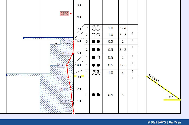
The snowpack became moist down to the ground in the northern regions due to warmth and precipitation in the form of rain at low and intermediate altitudes. Füssener Jöchle. 1720m, NE, 32°.
Profile from 26.12.2021 (c) Niedermayer, et.al.


Der wetterbegünstigte Süden. Blick von der Dolomitenhütte in Richtung Lienzer Dolomiten (c) foto-webcam.eu
The southern regions: favoured conditions. View from Dolomite refuge towards Lienz Dolomites 
(c) foto-webcam.eu


The warm front and expected effects on avalanche danger levels


Rainfall at low and intermediate altitudes / Swiftly rising snowfall level to about 2500 m

When in the western regions precipitation set in during the afternoon on 29.12.2021, a warm front from the northwest announced itself. The ZAMG Weather Service forecast precipitation amounts of 25 to 50 mm, more from place to place. This applies to all of North Tirol and northern East Tirol. Most of the precipitation is expected  in the western and northern regions of the land.

The fact is, precipitation at low and intermediate altitudes will be rainfall right from the start. At high altitudes it will be snowfall to begin with. However, the snowfall up to about 2500 m will rapidly turn to rainfall. The major intensity of this precipitation is anticipated for the nighttime hours of 29.12.


24h-Neuschneeprognose vom 29.12. auf den 30.12.2021. Da es sich um eine NEUSCHNEE-Prognose handelt, wird hier aufgrund der steigenden Regengrenze NICHT der Gesamtniederschlag angegeben!
24-hr forecast (29.12-30.12) of fresh snow expectation. Since this is a forecast of NEW SNOW,
overall precipitation is NOT shown, due to the ascending rainfall level.


Storm-strength winds in the mountains

Yesterday (28.12) winds intensified at high altitudes. Now we have to expect really stormy conditions in the mountains. Winds blowing mainly from the northwest.


Zunehmend starker bis stürmischer Wind aus West bis Nordwest. Windeinfluss wird in der Höhe neue, z.T. sehr umfangreiche Triebschneeansammlungen bilden.
Increasingly strong-to-stormy W/NW winds. Wind impact will generate far-reaching snowdrift accumulations in some places at high altitudes.


Windprognose für 29.12.2021 Mitternacht
Wind forecast for midnight 29.12.202


Naturally triggered avalanche activity

Based on the weather forecast, we assume there will be increased naturally triggered avalanche activity. That means several avalanche problems will overlap, potential avalanche scenarios will criss-cross.

In regions influenced by rainfall we have a wet-snow problem. Thus, we expect the following types of avalanches:
  • wet loose-snow avalanches in extremely steep terrain in all aspects
  • glide-snow slides and avalanches on steep grass-covered slopes in all aspects
  • moist / wet slab avalanches particularly in west-facing, north-facing and east-facing terrain

Due to the rather shallow snowpack, loose-snow and glide-snow avalanches will predominantly be of medium size.


Bereits um den 13.12. sind in Tirol sehr viele Gleitschneerutsche und -lawinen abgegangen. Erhöhte Abgangsbereitschaft in vom Regen beeinflussten Gebieten u.a. dort, wo sich bereits Gleitschneemäuler aufgetan haben. Tuxer Alpen (Foto: 28.12.2021)
 On 13.12 there were numerous glide-snow slides and avalanches triggered. Heightened likelihood in regions influenced by rainfall, i.e. wherever glide cracks opened on the surface.
Tux Alps (photo: 28.12.2021)


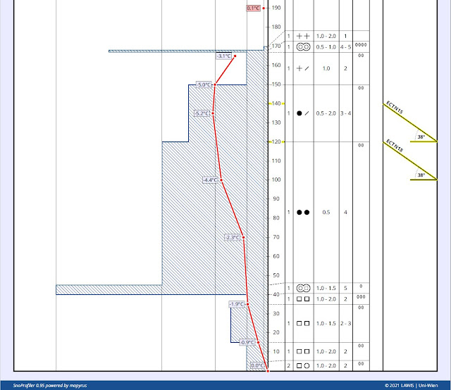
Moist slab avalanches, on the other hand, can also grow to large size, due to area-wide fracture propagation. There are two different types of moist slab avalanches which depend on the length of time the snowfall persists before turning to rain. Wherever there is more snowfall at the beginning, slab avalanches will fracture primarily in the zone of the current old snowpack surface, particularly beneath thin crusts atop a weak layer of faceted crystals. Wherever it snows only for a short time or not at all, the rain will swiftly penetrate the “warm” snowpack, depending on altitude and aspect. There we currently find a weak layer at mid-level inside the snowpack which formed in early winter. This was not triggerable in recent weeks. But penetrating, seeping water dissolves the bonding between crystals and reactivates this weak layer. This is then a wet-snow problem, just as we know it from early spring. In isolated cases the activation of this weak layer is only possible through the additional loading of the rain. 


Der türkisene Pfeil symbolisiert das in die Schneedecke eindringende Regenwasser. der Pfeil in magenta zeigt die Schwachschicht, die durch Regen geschwächt wird. Schneeprofil auf 2050m, NW, 30° Elfer Bergstation, Nördliche Stubaier Alpen (c) Larcher et. at.
Turquoise arrow symbolizes rain water seeping into the snowpak. Magenta arrow shows the weak layer being weakened by rain. Snow profile at 2050 m, NW, 30°
Elfer mountain station, northern Stubai Alps  (c) Larcher et. at.


Das Bild zeigt einerseits den simulierten Schneehöhenverlauf der Wetterstation Nachtweide in der Silvretta Skiregion. Andererseits wird in den Blautönen in die Schneedecke eindringendes Wasser anhand eines berechneten Indizes dargestellt. Der graue vertikale Strich zeigt den Zeitpunkt 29.12. 14:00 Uhr an. Unter Einbeziehung von Wettermodellen wird in die Zukunft geschaut. In den Nachtstunden vom 29.12. auf den 30.12. soll die Schneedecke am Stationsstandort auf 2030m bis zum Boden durchnässt werden.
This picture shows, on the one hand, the simulated course of snow depths at Nachtweide weather station in the Silvretta ski region during this winter. On the other, blue-shaded areas show the seeping water calculated by a series of bellwethers. The gray vertical line shows the time 29.12 at 2:00 pm. Using weather models, we can gaze into the future. During the nighttime hours on 29.12 - 30.12 the snowpack at the measurement station at 2030 m becomes thoroughly wet down to the ground.


Naturally triggered slab avalanches in regions not influenced by rainfall


Another scenario exists with regard to naturally triggered slab avalanches in regions where there is persistent snowfall, or at least mostly snowfall. A weak layer for slab avalanches is seen in the old snowpack on 29.12. As mentioned, this is an expansively metamorphosed (faceted) weak layer which often is deposited beneath thin melt-freeze crusts or wind crusts.


Eine dünne Eislamelle an der Schneeoberfläche, darunter lockere, kantige Kristalle - die für die kommende Schneeauflage primäre Schwachschicht. Tuxer Alpen (Foto: 28.12.2021)
A thin film of ice on the snowpack surface, and loose faceted crystals beneath that , i.e. the primary weak layer for the approaching layer of new snow. Tux Alps (photo: 28.12.2021)


Schneefall, Erwärmung und Windeinfluss werden in größeren Höhen ein "perfektes" Brett über einer zum Teil recht flächigen Schwachschicht ausbilden. Erste Verfrachtungen in den Tuxer Alpen am 28.12.2021
Snowfall, higher temperatures, wind impact together generate the “perfect slab” in an area-wide weak layer. Initial snow transport in the Tux Alps on 28.12.2021


Nach den Niederschlägen wird man vermehrt Schneebrettlawinen beobachten können. Brüche sind sowohl in oberflächennahen als auch tieferen Schwachschichten vorstellbar. Schneebrettabgang Zillertaler Alpen (Foto: 24.12.2021)
Following precipitation, increasingly frequent slab avalanches will be observed. Fractures occur both in the surface-near layers as well as in weak layers deeper down in the snowpack.
Slab release Zillertal Alps (photo: 24.12.2021)


Another scenario occurs in high alpine regions in glacial terrain. Through the additional loading of new snow and snowdrift accumulations, but also through primary surface-near naturally triggered avalanches, ground-level weak layers can be triggered. In isolated cases, large-sized avalanches are then possible. As a rule, these are zones which are far away from any and all infrastructure facilities.

 
"Mudslides with snow"

However in the framework of current weather forecasts it is also imaginable that we will have “mudslides with snow” in those areas where precipitation is heaviest and most rain-impacted. When the ground is saturated with water, the ground itself can start to move and subsequently take the snow along with it. Such an occurrence was experienced on 17.11.2019 in Stubai Valley.


Coming developments

Naturally triggered wet-snow avalanche activity is expected to diminish significantly when the precipitation eases tomorrow (30.12). Isolated dry-snow avalanches are then imaginable especially on very steep slopes at high altitudes where wind impact has deposited large amounts of snow.

What remains to deal with, for now, is well formed “slab” in the form of new snow and snowdrift, formed at high altitudes through the influence of the warm front. In our experience, that is when we ordinarily have especially good success with explosives, i.e. artificial triggerings. In some places we have to expect large slab avalanches which are triggered by winter sports enthusiasts, particularly at high altitudes.

As a result of higher temperatures over New Year’s Day (zero-degree level above 3000 m), Danger Level “high” will incrementally diminish at high altitudes.

We will make every effort to update this blog before the end of the year.

Friday 24 December 2021

Persistent weak layer, isolated danger zones. Fresh drifts: snow quality frequently poor.

Persistent weak layer problem: isolated danger zones, esp. on very steep shady slopes


Our snowpack analysis and reports from winter sports enthusiasts confirm a persistent weak layer, continually diminishing yet in isolated cases still evident and, all in all, quite delicate to discern. Avalanche prone locations are found especially on very steep shady slopes above about 2200 m, but also on sunny slopes at high altitude. Avalanche triggerings are possible, particularly in transition zones from shallow to deep snow. The fractures mostly occur at mid-level inside the snowpack.


Sehr vereinzelt noch zu beobachten: Schneebrettauslösung durch Fernauslösung in der Glockner Gruppe. (Foto: 15.12.2021 (c) Toni Riepler)
Very isolated: slab released by remote triggering. The highly varied snow depths are typical, and fascinating. Glockner Massif. (photo: 15.12.2021 (c) Toni Riepler)


Spontane Lawinenauslösung aufgrund stürmischen Windes und der in Folge zu großen Zusatzbelastung des frischen Triebschnees. Zentralosttirol (Foto: 20.12.2021)
Following large additional loading by freshly generated drifts, a naturally triggered avalanche due to stormy winds. Central East Tirol. (photo: 20.12.2021) 

Two reports reached us this week about naturally triggered slab releases in which fractures occurred in ground-level weak layers on glacial ice. One was on the Manigenbachkogel in the Gurgler Massif at 3200 m, NE; another was below the Gabler in the Zillertal Alps at 2850 m, NW. Also in this case, the loading of the fresh snowdrifts was probably the trigger. Comparisons  to the avalanches in the beginning of November in glacier zones, but also in our last Blog about the avalanche on the Linker Fernerkogel.


Persistent weak layer usually easy to recognize

What marked last week was the weather: at high altitudes often storm-strength winds, usually northerly or westerly.


Wetterstation St. Veit Zischke im Defereggental. Stürmischer Wind um den 20.12.2021. Schneeverfrachtungen auch unterhalb der Waldgrenze waren die Folge. Abgesehen davon: Meist sonnig.
Weather station St. Veit Zischke in Defereggental. Stormy winds on 20.12.2021. The result: snow transport even below the timberline. Aside from that it was generally sunny.


Windeinfluss führte zu ungleicher Schneeverteilung. Sattelberg. (Foto: 16.12.2021)
Wind impact led to highly irregular snow distribution. Sattelberg. (photo: 16.12.2021)


Wechtenbildung in den Zillertaler Alpen (Foto: 19.12.2021)
Cornices in the Zillertal Alps (photo: 19.12.2021)

The snowdrift problem is currently limited to steep terrain and there, especially behind protruberances. Ridgeline terrain is also at risk. With some experience in on-site avalanche assessment, such danger zones can easily be recognized and circumvented. Caution urged particularly where fresh drifts were deposited on surface hoar or thin melt-freeze crusts (with loose crystals beneath them) since they are easy to trigger.


Only isolated glide-snow avalanches


Nach einer sehr hohen Gleitschneeaktivität um den 13.12. werden uns aktuell nur mehr sehr wenige Gleitschneelawinen gemeldet. Karnische Alpen (Foto: 16.12.2021)
After intense glide-snow activity around 13.12, glide-snow avalanches are now being reported only rarely. Carnic Alps (photo: 16.12.2021)


Snow quality: frequently poor

The snowpack surface was recently subjected to high wind impact, at least above the treeline. In addition, due to rain impact (12-13.12.2021) and subsequent solar radiation, a thin melt-freeze crust was generated widespread, dampening skiers’ enthusiasm. In some places, e.g. Carnic Alps, the thin rain crust on shady slopes has now been transformed to loose crystals. Wherever there was no wind, conditions in the Carnic Alps are better.


Melt-freeze in the Lechtal Alps (photo: 20.12.2021)


Grober Überblick der Krustenbildung an der Schneeoberfläche. Ausgewertet wurden sämtliche Rückmeldungen von unseren Beobachtern, von WintersportlerInnen sowie Schneeprofile. Inneralpin sowie im südlichen Osttirol liegt die Höhengrenze etwas tiefer. Sonnseitig sind dort allerdings auch höher gelegene Bereiche betroffen.
Rough overview of crusts on the snowpack surface. All the reports we received have been fed into this overview, and added to snow profiles. In inneralpine zones such as southern East Tirol the altitudes lie somewhat lower. On sunny slopes, however, they also occur at higher altitudes there.

Mancherorts liegt für ein ungetrübtes Skivergnügen einfach noch (zu) wenig Schnee. Nördliche Stubaier Alpen (Foto: 14.12.2021)
In some places there is just not enough snow for good skiing. Northern Stubai Alps (photo: 14.12.2021)


Surface hoar

What is fascinating to us is the increased formation of surface hoar: similar to superficial crusts, evidently widespread, at least below the timberline, but  on shady slopes and in flat terrain also above it. It seems to have formed predominantly at the fogbank borderlines (15.12.2021).


Oberflächenreif: Schön anzusehen. Kritisch wirds immer, wenn dieser überschneit bzw. überweht wird. Grubenkopf, Zentrale Stubaier Alpen (Foto: 14.12.2021)
Surface hoar: visually beautiful, but dangerous when covered with snow or snowdrifts.
Grubenkopf, Central Stubai Alps (photo: 14.12.2021)


An der Nebelgrenze bildet sich bevorzugt ein schmales Band an Oberflächenreif. (Foto: 16.12.2021)
At the fogbank borderline, a narrow band of surface hoar tends to form. (photo: 16.12.2021)


Sehr bezeichnend: Oberflächenreif, darunter eine dünne Schmelzkruste, darunter eine dünne Schicht aus lockeren Kristallen. Salfeins. 2000m, O. Profil vom 15.12.2021 (c) Anna Siebenbrunner
Very instructive: surface hoar; below that a thin melt-freeze crust; below that a thin layer of loose crystals. Salfeins. 2000m, E. Profile from 15.12.2021 (c) Anna Siebenbrunner


Since the structure of the snowpack surface plays a decisive role in the ongoing development of avalanche danger levels, we are grateful for information about the character of the snowpack surface, particularly observations about melt-freeze crusts and surface hoar (with accompanying data of altitude and aspect). Please send information via mail to: lawine@tirol.gv.at.


Outlook for the holidays

The ZAMG Weather Service describes the current weather situation this way: “The Alps are in the grip of a northwesterly air current which will be brushed by a warm front bringing warmer air masses. In the wake of this front, a westerly air current will bring mild but not overly moist air masses our way.”

That means that no significant changes are to be immediately expected in the avalanche situation. New avalanche prone locations will be generated in particular where the thin crusts and surface hoar which currently compose the snowpack surface get blanketed by fresh snow.


MERRY CHRISTMAS!


On behalf of the entire team at the Avalanche Warning Service of Tirol, we send you our very best wishes for a Happy Christmas.


Einer der vielen Kraftplätze Tirols für besinnliche Weihnachten. (Foto: 23.12.2021)
One of Tirol’s many power spots for contemplative holidays. (photo: 23.12.2021)

Friday 17 December 2021

Briefly high avalanche activity! Main problem: shallow snow zones, very steep, shady slopes above treeline.

 Rainfall with multiple effects


Heightened glide-snow activity


The most startling thing last week was the briefly heightened glide-snow activity from 12.12 until 13.12.2021. The influence of warmth combined with rainfall increased the water content of the snowpack, thereby reducing the resistance to a gliding snowpack over steep grass-covered slopes.

 
Regenrinnen, Gleitschneemäuler und -lawinen im Außerfern (Foto: 14.12.2021)
 Rain grooves, glide cracks and glide-snow avalanches in Ausserfern (photo: 14.12.2021)


The red line shows the snowpack’s temperature profile. At ground-level and on the surface, 0° C was measured (ground warmth flow from below incl. rain and warmth from above). 2060 m, SE, 30°. Kastnerberg, central Stubai Alps  (Profile from 15.12.2021) (c) Stefanie Höpperger


Gleitschneeaktivität (auch vor dem Regen) in den schneereicheren Regionen Osttirols. Sillian (Foto: 11.12.2021)
Glide-snow also active prior to the rainfall, namely, in the regions where snowfall was heaviest, like here in southern East Tirol. (photo: 11.12.2021)


Moist / wet loose-snow avalanches


Parallel to glide-snow avalanches, increasingly frequent moist or wet loose-snow avalanches and slides released in extremely steep terrain in the rain-impacted zones.


Lockerschneerutsche in der Westlichen Verwallgruppe. Zudem erkennt man Gleitschneeaktivität. (Foto: 16.12.2021)
Loose-snow slides in western Verwall Massif. Glide-snow activity is also visible. (photo: 16.12.2021)


Distribution of precipitation


Niederschlagsverteilung vom 12.12. auf den 13.12. in Tirol. Nirgends war es richtig viel. Die Schneefallgrenze lag häufig zwischen 2000m und 2300m, lokal auch höher.
Distribution of precipitation from 12.12 to 13.12 in Tirol. Nowhere was precipitation high. The snowfall level often lay between 2000m and 2300m, higher from place to place.


Immer wieder Niederschlag. Regen gabs mit Temperaturanstieg vom 12.12. auf den 13.12.
Repeated bouts of precipitation. There was rainfall from 12.12 til 13.12 due to higher temperatures.


For a brief spell, numerous wind sensors were out of operation


What was striking was that many wind stations abruptly went out of kilter on 13.12, registering zero for several hours. This wasn’t because the wind went to sleep, but because very moist air masses and drizzle led to the stations briefly icing up. Due to persistently higher temperatures the coating melted and wind measurement functioned perfectly again.


Deutlicher Temperaturanstieg vom 12.12. auf den 13.12. Die Schneeoberflächentemperatur erreichte 0°, Die Windmessung funktionierte kurzfristig nicht mehr.
Marked rise in temperature from 12.12 to 13.12. The snowpack surface temperature reached 0° C.
Wind measurement was on the blink for a short time.


Deteriorating snow quality - breakable crusts


Skies cleared during the night of 13-14 December. The snow temperature dropped like a stone, causing something bad for winter sports enthusiasts: breakable crusts. In the rain-impacted regions a pronounced superficial melt-freeze crust was often observed on shady slopes up to 2300 m, in some places up to 2500 m, in isolated cases up to 2700 m. On sunny slopes it is currently found on steep slopes, depending on solar radiation up to nearly high alpine zones.


Eine Schmelzkruste an der Schneeoberfläche als Folge von Regen und anschließender Abkühlung bzw. nächtlicher Abstrahlung. Westliche Verwallgruppe (Foto: 16.12.2021)
A melt-freeze crust on the snowpack surface as a consequence of rainfall followed by dropping temperatures and nocturnal outgoing radiation. Western Verwall Massif (photo: 16.12.2021)


The long-term problem


Rainfall and moist snowfall up to high altitudes, is something that makes avalanche forecasters worry. If weather conditions are conducive, a striking weak layer could be generated immediately adjacent to this crust. A similar situation occurred last winter when a melt-freeze crust that formed just before Christmas then generated faceted crystals. That layer of faceted, loose snow crystals became a motor for accidents starting in mid-January which lasted for about a month.


Persistent weak layer slowly diminishing, but still treacherous

Whereas just a short while ago we were receiving ongoing reports of avalanche releases in the old snow, isolated reports of cracks and settling noises, such reports have successively decreased. Parallel to that, recent snowpack analysis shows a development towards a gradual improvement of the situation.


Lawinenauslösung eines einzelnen Wintersportlers am Hohen Aifner. Die Pfeile zeigen den Einfahrts- und Ausfahrtsbereich. WSW, 2500m (Foto: 12.12.2021)
One sole winter sports enthusiast triggers an avalanche on the Hohen Aifner. Arrows point to the entry and exit zones. W/SW, 2500m (photo: 12.12.2021)


Schneebrettabgang im Bereich der Murmentenkarspitze. Personen befanden sich zu diesem Zeitpunkt im Aufstieg. Der Pfeil symbolisiert den Aufstiegsbereich. (Foto: 12.12.2021)
A slab releases near the Murmentenkarspitze. At that moment there were persons on their ascent. The arrow symbolizes the ascent route. W, 2500m (photo: 12.12.2021)


Rissbildungen und Setzungsgeräusche im Nahbereich des Hochzeiger-Skigebietes (Foto: 12.12.2021)
Cracks forming, settling noises, near Hochzeiger ski area (photo: 12.12.2021)


Im Vordergrund eine massiv vom Wind geprägte Schneeoberfläche, im Hintergrund ein Lawinenanriss samt Ablagerung. Person konnte unverletzt entkommen. Leppleskogel - Osttirol (Foto: 14.12.2021)
In foreground, snowpack surface massively wind-impacted. In background, an avalanche fracture with its deposit. One person was able to bolt it without injuries. Grosser Leppleskogel - East Tirol
(photo: 14.12.2021) 


Lawine in magenta wurde unterhalb der Schwarzen Schneid in den Ötztaler Alpen durch eine Sprengung ausgelöst. Die in blau dargestellte Lawine brach unmittelbar (!) nach dem Sprengzeitpunkt und nicht erst durch die Belastung der abgehenden Lawine. Eine erstaunliche Bruchfortpflanzung vom Sprengpunkt aus. Die Schwachschicht stammt vom Herbst und befand sich oberhalb des Gletschereises. (Foto: 10.12.2021)
One avalanche (pink-shaded) below Schwarzer Schneid in the Ötztal Alps was triggered by an explosive. The other (blue-shaded) avalanche fractured immediately after the explosion, but not through the force of the released avalanche. An astonishing bit of fracture propagation from the point of explosion. The weak layer has persisted from autumn, located above the glacial ice. (photo: 10.12.2021)


A problem: shallow-snow zones and transitions from shallow to deep snow


Snowpack analysis which we conducted ourselves, alongside snow profiles we have been given, make the situation quite clear: problem zones do exist, especially shallow spots. On the other hand, the massively blanketed weak layers which formed in November (see earlier blogs) show few fractures or none at all. 


Schneeprofil mit einer störanfälligen Schwachschicht aus kantigen Kristallen und Schwimmschnee. Nord, 2080m, Östliche Rieserfernergruppe. Profil: Alois Mariacher, (14.12.2021)
 Snow profile with a trigger-sensitive weak layer of faceted crystals and depth hoar. North, 2080m, 30°. Eastern Rieserferner Massif. Profile: Alois Mariacher, (14.12.2021)


Weak layers in lower part of the snowpack could no longer be triggered during our tests. NE, 2300m, 38°. Profile from 15.12.2021. Western Lechtal Alps (c) Kärle/Perl  


Other impressions and a short outlook


The period right behind us has been profoundly influenced by winds. The snowpack surface was monumentally impacted. Snowdrift accumulations were triggerable only for a short time, rapidly stabilized as a result of the higher temperatures and the concomitant settling of the snowpack,

Viel Wind auf den Bergen. Tuxer Alpen (Foto: 08.12.2021)Viel Wind auf den Bergen. Tuxer Alpen (Foto: 08.12.2021)
Lots of wind in the mountains. Tux Alps (photo: 08.12.2021)

 
Powder at low altitudes where the wind didn’t play havoc. Arlberg. (photo: 10.12.2021)


The next few days will be dominated by a high-pressure front. Winds at high altitudes could be a disturbance, particularly starting on Friday. As of that point, keep a close eye on freshly generated snowdrifts, particularly near ridgelines at high altitude.


THE BOTTOM LINE


The persistent weak layer which we discussed thoroughly in recent blogs is still the most perilous threat for winter sports enthusiasts. Avalanche prone locations occur most frequently on shady slopes above the timberline where avalanches can still be triggered even by minimum additional loading, particularly in spots where the snow is shallow and in transition zones from shallow to deep snow. On sunny slopes, avalanches seem to be possible only by large additional loading, particularly at high altitudes (frequently above 2500 m).