Rainfall with multiple effects
Heightened glide-snow activity
The most startling thing last week was the briefly heightened glide-snow activity from 12.12 until 13.12.2021. The influence of warmth combined with rainfall increased the water content of the snowpack, thereby reducing the resistance to a gliding snowpack over steep grass-covered slopes.
") |
| Rain grooves, glide cracks and glide-snow avalanches in Ausserfern (photo: 14.12.2021) |
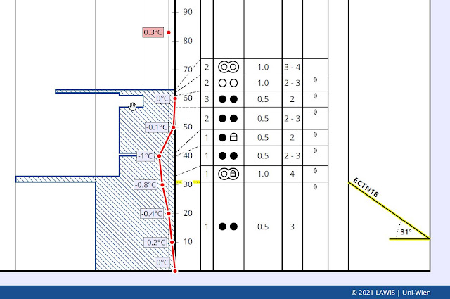 |
| The red line shows the snowpack’s temperature profile. At ground-level and on the surface, 0° C was measured (ground warmth flow from below incl. rain and warmth from above). 2060 m, SE, 30°. Kastnerberg, central Stubai Alps (Profile from 15.12.2021) (c) Stefanie Höpperger |
 in den schneereicheren Regionen Osttirols. Sillian (Foto: 11.12.2021)") |
| Glide-snow also active prior to the rainfall, namely, in the regions where snowfall was heaviest, like here in southern East Tirol. (photo: 11.12.2021) |
Moist / wet loose-snow avalanches
Parallel to glide-snow avalanches, increasingly frequent moist or wet loose-snow avalanches and slides released in extremely steep terrain in the rain-impacted zones.
") |
| Loose-snow slides in western Verwall Massif. Glide-snow activity is also visible. (photo: 16.12.2021) |
Distribution of precipitation
 |
| Distribution of precipitation from 12.12 to 13.12 in Tirol. Nowhere was precipitation high. The snowfall level often lay between 2000m and 2300m, higher from place to place. |
 |
| Repeated bouts of precipitation. There was rainfall from 12.12 til 13.12 due to higher temperatures. |
For a brief spell, numerous wind sensors were out of operation
What was striking was that many wind stations abruptly went out of kilter on 13.12, registering zero for several hours. This wasn’t because the wind went to sleep, but because very moist air masses and drizzle led to the stations briefly icing up. Due to persistently higher temperatures the coating melted and wind measurement functioned perfectly again.
 |
| Marked rise in temperature from 12.12 to 13.12. The snowpack surface temperature reached 0° C. Wind measurement was on the blink for a short time. |
Deteriorating snow quality - breakable crusts
Skies cleared during the night of 13-14 December. The snow temperature dropped like a stone, causing something bad for winter sports enthusiasts: breakable crusts. In the rain-impacted regions a pronounced superficial melt-freeze crust was often observed on shady slopes up to 2300 m, in some places up to 2500 m, in isolated cases up to 2700 m. On sunny slopes it is currently found on steep slopes, depending on solar radiation up to nearly high alpine zones.
") |
| A melt-freeze crust on the snowpack surface as a consequence of rainfall followed by dropping temperatures and nocturnal outgoing radiation. Western Verwall Massif (photo: 16.12.2021) |
The long-term problem
Rainfall and moist snowfall up to high altitudes, is something that makes avalanche forecasters worry. If weather conditions are conducive, a striking weak layer could be generated immediately adjacent to this crust. A similar situation occurred last winter when a melt-freeze crust that formed just before Christmas then generated faceted crystals. That layer of faceted, loose snow crystals became a motor for accidents starting in mid-January which lasted for about a month.
Persistent weak layer slowly diminishing, but still treacherous
Whereas just a short while ago we were receiving ongoing reports of avalanche releases in the old snow, isolated reports of cracks and settling noises, such reports have successively decreased. Parallel to that, recent snowpack analysis shows a development towards a gradual improvement of the situation.
") |
| One sole winter sports enthusiast triggers an avalanche on the Hohen Aifner. Arrows point to the entry and exit zones. W/SW, 2500m (photo: 12.12.2021) |
") |
| A slab releases near the Murmentenkarspitze. At that moment there were persons on their ascent. The arrow symbolizes the ascent route. W, 2500m (photo: 12.12.2021) |
") |
| Cracks forming, settling noises, near Hochzeiger ski area (photo: 12.12.2021) |
") |
| In foreground, snowpack surface massively wind-impacted. In background, an avalanche fracture with its deposit. One person was able to bolt it without injuries. Grosser Leppleskogel - East Tirol (photo: 14.12.2021) |
 nach dem Sprengzeitpunkt und nicht erst durch die Belastung der abgehenden Lawine. Eine erstaunliche Bruchfortpflanzung vom Sprengpunkt aus. Die Schwachschicht stammt vom Herbst und befand sich oberhalb des Gletschereises. (Foto: 10.12.2021)") |
| One avalanche (pink-shaded) below Schwarzer Schneid in the Ötztal Alps was triggered by an explosive. The other (blue-shaded) avalanche fractured immediately after the explosion, but not through the force of the released avalanche. An astonishing bit of fracture propagation from the point of explosion. The weak layer has persisted from autumn, located above the glacial ice. (photo: 10.12.2021) |
A problem: shallow-snow zones and transitions from shallow to deep snow
Snowpack analysis which we conducted ourselves, alongside snow profiles we have been given, make the situation quite clear: problem zones do exist, especially shallow spots. On the other hand, the massively blanketed weak layers which formed in November (see earlier blogs) show few fractures or none at all.
") |
| Snow profile with a trigger-sensitive weak layer of faceted crystals and depth hoar. North, 2080m, 30°. Eastern Rieserferner Massif. Profile: Alois Mariacher, (14.12.2021) |
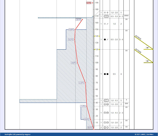 |
| Weak layers in lower part of the snowpack could no longer be triggered during our tests. NE, 2300m, 38°. Profile from 15.12.2021. Western Lechtal Alps (c) Kärle/Perl |
Other impressions and a short outlook
The period right behind us has been profoundly influenced by winds. The snowpack surface was monumentally impacted. Snowdrift accumulations were triggerable only for a short time, rapidly stabilized as a result of the higher temperatures and the concomitant settling of the snowpack,
") |
| Lots of wind in the mountains. Tux Alps (photo: 08.12.2021) |
 |
| Powder at low altitudes where the wind didn’t play havoc. Arlberg. (photo: 10.12.2021) |
The next few days will be dominated by a high-pressure front. Winds at high altitudes could be a disturbance, particularly starting on Friday. As of that point, keep a close eye on freshly generated snowdrifts, particularly near ridgelines at high altitude.
THE BOTTOM LINE
The persistent weak layer which we discussed thoroughly in recent blogs is still the most perilous threat for winter sports enthusiasts. Avalanche prone locations occur most frequently on shady slopes above the timberline where avalanches can still be triggered even by minimum additional loading, particularly in spots where the snow is shallow and in transition zones from shallow to deep snow. On sunny slopes, avalanches seem to be possible only by large additional loading, particularly at high altitudes (frequently above 2500 m).