Friday 29 April 2022

Main danger: loose-snow avalanches + small snowdrift accumulations in high-alpine shady ridgeline steep terrain

Ongoing quite favorable conditions, slight daytime increase in danger


The big message: currently (28.04) there are very few avalanche problems. Loose-snow avalanches on extremely steep slopes and small fresh snowdrifts in high-alpine shady terrain are the main dangers. During the course of the day the snowpack surface softens on sunny slopes and loses some of its firmness.


Lockerschneerutsche aus extrem steilem Gelände. Stubaier Gletscher. (Foto: 28.04.2022)
Loose-snow slides in extremely steep terrain. Stubai glacier. (photo: 28.04.2022)


Gering mächtiges Schneebrett im extrem steilen, schattigen Gelände unterhalb der Vorderen Jamspitze in der Silvretta. 2900m, NNO. Eingekreist erkennt man eine dünne Kruste, die am 25.04. entstanden ist. Darunter bildete sich in kurzer Zeit aufgrund großer Temperaturgegensätze (Gefahrenmuster "kalt auf warm") eine dünne Schwachschicht. Dieses Problem ist wohl nur sehr vereinzelt anzutreffen. Meist wird das über der Schwachschicht befindliche Brett wohl zu wenig ausgeprägt sein. Vorsicht am ehesten in unmittelbarem Kammbereich.
Shallow slab in extremely steep shady terrain below Vordere Jamspitze, Silvretta, 2900m, N/NE. Encircled: thin crust which formed on 25.04. Below it, a thin weak layer formed in a short time due to big temperature contrasts (danger pattern “cold on warm”). This problem crops up only in very isolated cases, the slab which forms above the weak layer is usually not pronounced. Caution urged in immediate Ridgeline terrain.


Weather review

Last week did honor to the month of April. Repeated bouts of precipitation, often strong-velocity winds from varying directions, rather cool for this juncture of the season. Starting on 27.04 weather conditions improved. Very dry air.


Wechselhaft: Ab 27.04. Wetterbesserung. Pitztaler Gletscher
Variable: as of 27.04. improved weather conditions. Pitztaler Gletscher


Ergänzend zu obiger Grafik: Im mittleren Balken wird gemeinsam mit der Lufttemperatur (rot) und dem Taupunkt (blau) auch die Schneeoberflächentemperatur (grau) dargestellt. Gute nächtliche Ausstrahlung am 28.04. und 29.04.)
Complementing the above graph: middle row depicts snowpack surface temperature (gray), together with air temperature (red) and thawing point (blue). Good nocturnal outgoing radiation on 28.04 and 29.04.


12h-Schneedifferenz 23.04. auf 24.04.2022
12hr-snow depth difference 23.04. - 24.04.2022


Der "hot-spot" der Niederschläge am 24.04. war bei der Station Timmelsjoch in der Gurgler Gruppe.
The hot spot of precipitation on 24.04 was at the Timmelsjoch station in the Gurgler Massif.
 

Neuerliche Niederschläge zwischen dem 24.04. und dem 27.04.
More precipitation on 24.04-25.04


Powder snow and firn

There was a brief spell when superb powder and good firn was enjoyed, in some places immediately following on the heels of the other). Due to the dry air that might be true tomorrow, 29.04. Thereafter the powder will be blanketed by a crust also in high alpine terrain.

 
Pulverschnee auf 3000m in den Stubaier Alpen (Foto: 28.04.2022)
Powder snow at 3000 m in the Stubai Alps (photo: 28.04.2022)


"Archiv"-Foto vom 18.04. mit tollem Firn in den Zillertaler Alpen. Ähnliches gibts aktuell auch in steilen besonnten Hängen.
A photo from the 18.04 “archives.” Great firn in the Zillertal Alps, still to be enjoyed on steep sunny slopes.


A glance beneath the snowpack

As mentioned before, we are currently concentrating on the potential near-surface weak layers which have formed over the last few days due to dp.4. This means high alpine shady terrain. Due to only minor amounts of recent snowfall (usually 10-20 cm) and based on reports and snowpack analysis, we assume the problems are quite isolated. Caution urged in immediate ridgeline, extremely steep high alpine terrain. The risks of taking a fall are higher than those of being buried in snow masses.


Auf 3040m, NO in den Stubaier Alpen konnten im Bereich von Krusten nur Teilbrüche erzeugt werden. Schwachschichten waren dort also zu wenig ausgeprägt, als dass sie gefährlich hätten sein können. (Foto: 28.04.2022)
At 3040m, NE, Stubai Alps, only partial fractures could be generated near the crusts. Weak layers were not sufficiently pronounced to become a danger. (photo: 28.04.2022)


The poorest snow quality is currently to be found in shady terrain at 2300m. There the snowpack is thoroughly wet down to lower layers. That is where you break through most easily.

Isotherm snow profile at 2260m in the Silvretta from 26.04.2022


On 30.04 our last Avalanche Bulletin of the season (with forecast for 1 May) will be published. Blogs will be published whenever the snow and avalanche situation changes significantly.


Der Frühling ist nicht mehr aufzuhalten... (Foto: 20.04.2022)
Spring is here... (photo: 20.04.2022)

We thank all of you enormously for the numerous, valuable reports.

Thursday 21 April 2022

Mostly quite good conditions – Danger zones where snowpack is wet, esp. on very steep shady slopes above 2500m

Southerly foehn will bring some precipitation, esp. to southern regions


Following an extremely dry month of March, April has still not brought much precipitation. A bit is scheduled to arrive starting on Sunday, 24.04 due to foehn influence, especially in southern regions in Tirol (Gurgler Massif incl. East Tirol).


Der Alpenhauptkamm am 21.04.2022 als Wetterscheide: Im Süden bereits bedeckt, im Norden großteils sonnig. Gurgler Gruppe
Main Alpine Ridge as weather divide on 21.04.2022: overcast skies in the south, mostly sunny in the north. Gurgler Massif


Während der vergangenen Woche dominierten im Bereich der Adlersruhe Wolken. Aktuell erkennte man die Drehung des Windes auf Süd und nach zwei sonnigen Tagen inzwischen bedeckten Himmel.
Clouds dominated last week near the Adlersruhe. The wind shifting to southerly is visible, then overcast skies following two sunny days.


Mostly favorable conditions – Focus on thoroughly wet snowpack on shady slopes at 2500m

Low avalanche danger for the most part last week, with just a slight daytime cycle which heightened danger to moderate. Only on Friday, 15.03, was there a brief wet-snow cycle. So our focus is now on shady slopes at 2500m. As the wetness penetrates deeper, increasingly frequent loose-snow and mostly small-to-medium slab avalanches will be the result. Due to the character of April weather, forecasts that reach over several days are doomed to failure, should this happen. We simply have to observe the situation each day, since even minor weather changes can cause huge effects on the wetness of the snowpack. Keep an eye on diffuse radiation and high air moisture and warm temperatures. Other than that, all is quiet in outlying terrain.


Following snowfall, more frequent loose-snow avalanches

A classic pattern is the sure-fire appearance of loose-snow avalanches in extremely steep terrain following snowfall at this time of year. Due to presumably modest amounts of fresh snow, as forecast by ZAMG Weather Service for Sunday, 24.04, the loose-snow avalanches will probably remain mostly small.


Below-average snow depths

As noted in the Blog on 31.03, snow depths for this juncture of the season are below average. Here are a few impressions of present conditions...


Haggen im Sellraintal (Foto: 12.04.2022)
Haggen in Sellraintal (photo: 12.04.2022)


Haggen im Sellraintal - Vergleichsfoto Mitte April 2021
Haggen in Sellraintal - photo for comparison, mid-April 2021


In tiefen und mittleren Höhenlagen sowie sonnseitig bis in große Höhen aper - Lüsenstal (Foto: 18.04.2022)
Bare ground up to high altitudes at low and intermediate altitudes and on sunny slopes - Lüsental
(photo: 18.04.2022)


Krokusblüte - der Frühling kehrt ein. Gurgler Gruppe (Foto: 20.04.2022)
Crocuses in bloom - spring arrives. Gurgler Massif (photo: 20.04.2022)


Review of one-day wet-snow cycle on 15.04.2022

As referred to above, and also mentioned in the last Blog, on 15.04 we faced a wet-snow problem. Instead of the anticipated isolated naturally triggered avalanches, they turned out to be numerous. The situation was facilitated by rainfall. Here are a few impressions of that...


Im Laufe des Freitag, 15.04. begann es bei der Station Hahnenkamm in den Kitzbüheler Alpen zu regnen. Am 16.04. hatte der Nassschneezyklus in Schattenhängen insbesondere auch aufgrund der sinkenden Temperaturen (NO-Strömung) ein jähes Ende.
Rainfall set in on Friday, 15.04, at Hahnenkamm station in the Kitzbühel Alps. On 16.04 the wet-snow cycle came to an abrupt end on shady slopes, due to dropping temperatures (NE air current).


Vielfach lösten sich am 15.04. nasse Lockerschneelawinen. Östl. Deferegger Alpen
Wet loose-snow avalanches released frequently on 15.04. East Tirol, Deferegger Alps


Anflug der Christophorus-Crew zu einem Lawinenabgang auf der Nordseite des Glungezers in den Westlichen Tuxer Alpen. 2300m. Es wurde niemand verschüttet. (Foto: 15.04.2022)
Flight of Christophorus crew to an avalanche on the Glungezer north flank, western Tux Alps. 2300m.
No one was buried. (photo: 15.04.2022)


Ebenso nordseitig zwischen etwa 2300m und 2500m vermehrte spontane Lawinenabgänge. Wildlahnertal. Nördliche Zillertaler Alpen ( Foto: 18.04.2022)
On a north-facing slope at 2300-2500m, numerous naturally triggered avalanches.
Wildlahnertal, northern Zillertal Alps (photo: 18.04.2022)


Pfeile: Spontane Lockerschneelawinen; Magenta: Spontanes Schneebrett, Nordseite Nederkogel in der Gurgler Gruppe (Foto: 20.04.2022)
Arrows: naturally triggered avalanches. Pink shading: naturally triggered slab, north flank of Nederkogel, Gurgler Massif (photo: 20.04.2022)

Friday 15 April 2022

(Daytime) wet-snow problem & diminishing persistent weak layer

 Snowpack becoming moister

With clouds moving in during the night of 14.04-15.04, the snowpack will not cool down during the nocturnal hours. Particularly in an altitude belt around 2300m the moistness will then sink down to deeper layers which have been dry until now. Thereby, the snowpack will lose firmness. The likelihood of moist or wet snow slides, primarily triggered by winter sports enthusiasts, in isolated cases also naturally triggered, thus increases.


The curve of surface temperatures is flattening visibly. The thaw point rose for the first time above 0°C. This is an indicator of the snowpack rapidly becoming thoroughly wet at the place the profile is made.


Selbst auf 3000m haben wir es am 14.04. spätabends mit einer oberflächig feuchten Schneedecke am Profilstandort (Gletscherskigebiet Sölden) zu tun.
Even at 3000m the snowpack was superficially moist where the profile was made
(Glacier Ski Area Sölden, 14.04 late evening).

Caution urged particularly where diffuse radiation leads locally to intensified energy seepage and thereby reinforces the melting process. It is clear that snow quality is currently deteriorating.
 

Risse in der Schneedecke als Vorboten möglicher Gleitschneelawinen (Foto: 12.04.2022)
Glide cracks in the snowpack as red flags of potential glide-snow avalanches. As more water seeps into the snowpack, the likelihood of a release increases. (photo: 12.04.2022)


Diminishing persistent weak layer

In our last last Blog we pointed out the development of superficial weak layers above 2600m. This problem has receded in the interim. This applies currently most of all to W/NW to N to E/NE aspects. Caution urged especially on very steep to extremely steep slopes where many snowdrift accumulations were deposited last week. This is a problem which is extremely difficult to evaluate and pinpoint. A view into the snowpack down to the area of the colored layer of Sahara dust from mid-March is helpful.


Bei Schneedeckenuntersuchungen konzentrieren wir uns vermehrt auf oberflächennahen Schichten bis zur Saharastaubschicht, die am Bild gut zu erkennen ist. Dort haben sich in jüngerer Vergangenheit teilweise Schwachschichten gebildet. Vereinzelt sind diese bösartig und somit noch störanfällig. Stubaier Alpen (Foto: 12.04.2022)
When analysing the snow we conce pntrate currently on superficial layers down to the layer of Sahara dust, easily recognised in the photo. Weak layers have recently formed precisely at that point. In isolated cases they are malignant and prone to triggering. Stubai Alps (photo: 12.04.2022)


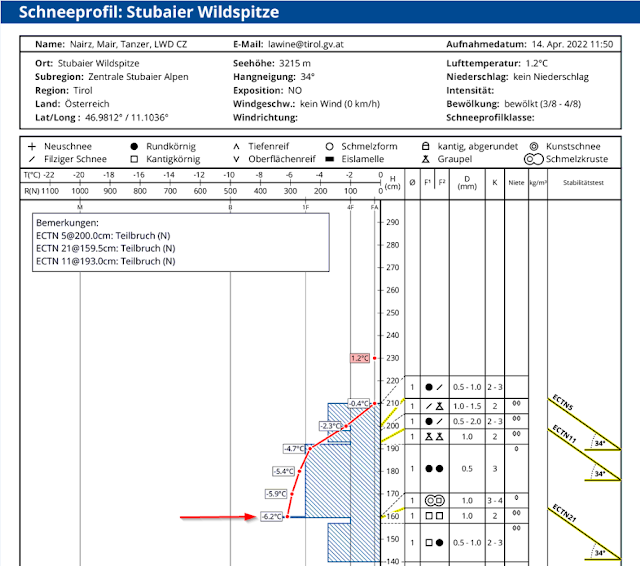
Arrow points to the colored layer of Sahara dust. Beneath it a soft layer of faceted crystals is recognizable. In some places a thin layer of faceted crystals has formed above the Sahara layer. Near the surface there is frequently graupel. 


Das Foto gehört zu obigem Profil: Oberer Pfeil zeigt auf eine Graupelschicht, der untere auf die Saharastaubschicht von Mitte März. Die Brüche waren unvollständig. (Foto: 14.04.2022)
This is a photo of the profile above: upper arrow points to a graupel layer, lower arrow to the layer of Sahara dust from mid-March. The initiated fractures were not completed. (photo: 14.04.2022)


Neuschneeprognose von Freitag, 08.04. bis Sonntag, 10.04.2022. Während dieser Niederschläge lagerte sich vielerorts eine zum Teil auch recht ausgeprägte Schicht aus Graupelkörnern ab.
Fresh snow forecast from Friday, 08.04 until Sunday 10.04.2022. A pronounced layer of graupel kernels was deposited in many places during this period of precipitation.

Recent avalanches: triggered exclusively in weak near-surface layers


A few pictures follow of recently reported avalanches in Tirol. What all the releases have in common: weak near-surface layers triggered them due to dp.4 (cold on warm) or dp.9 (graupel).


Westliche Liebenerspitze, 3200m, SW (Foto: 10.04.2022)
Western Liebenerspitze, Ötztal Alps, 3200m, SW (photo: 10.04.2022)


Kammnahes Schneebrett Wildebene; 2600m, N (Foto: 11.04.2022)
Ridgeline slab Wildebene, Arlberg region; 2570m, NW (photo: 11.04.2022)


Schneebrettlawine vom 12.04. im Bereich der Knotenspitze in den Nördlichen Stubaier Alpen.
Slab avalanche on 12.04 near Knotenspitze, northern Stubai Alps.


Drei spontane Schneebrettlawinen vom 12.04. am Marzellkamm in den Ötztaler Alpen, 2930m-3050m, NO (Foto: 13.04.2022)
Three naturally triggered slab avalanches on 12.04 on Marzellkamm, Ötztal Alps, 2930m-3050m, NE (photo: 13.04.2022)

What’s next?

In northern regions, ample clouds and some precipitation; in southern East Tirol, it will be pretty dry. That's how the ZAMG Weather Service forecast looks until Easter Sunday, 16.04. Temperatures are currently dropping, on Easter Monday they will rise again.

In case there is serious snowfall anywhere, numerous loose-snow avalanches can be expected in extremely steep terrain as soon as skies brighten again. Otherwise, springtime conditions will continue, including a daytime avalanche danger cycle. All in all, we then expect quite favorable conditions.


Abfahrtsgenuss im Gschnitztal (Foto: 12.04.2022)

Tuesday 12 April 2022

All signs point to Danger Pattern 4 (cold on warm) at high altitudes

Following snowfall, trigger-sensitive weak layer highly probable due to dp.4


Weak layer caused by dp.4 (cold on warm)

In our last Blog we referred to the “small snowdrift problem at high altitudes” and the possible development of Danger pattern “cold on warm” (dp.4). Back then on 07.04 we had no information about the development of a malicious weak layer. In the interim reports keep coming in about slab avalanches in a superficial weak layer due to Danger Pattern dp.4.

Based on current information we can narrow down the problem zones due to dp.4 to the following:

  • Regions where recent snow was heavy, particularly Silvretta, Arlberg region, Karwendel, regions along the Main Alpine Ridge and northern East Tirol
  • Shady slopes between 2600 and 2800m
  • Sunny slopes above 2800m, even more above 3000m

Anhand der Monatsgrafik der Station Pitztaler Gletscher erkennt man nicht nur den Beginn der Niederschläge ab dem 31.03., sondern auch folgende Temperatursprünge samt kürzlich kräftigem Windeinfluss.
On the monthly graph from the Pitztal Glacier station we recognize not only the start of precipitation on 31.03 but also the temperature leaps which followed, including brief period of high wind impact.


Weak layer due to dp.9 (covered graupel)

Just as conceivable, however, are massive deposits of graupel which were blanketed by the recently generated snowdrift accumulations in all aspects. Graupel precipitation was repeatedly observed during the last round of precipitation. Similar to dp.4, we assume that problem zones are evident above about 2600m.

Some reports about avalanches

Avalanche releases were reported from Wildebene and Albonakopf in the Arlberg region, from Felderkogel in the Ötztal Alps, from Grossglockner in the Glockner Massif and from Grosser Geiger (SW, 3200m) in the Venedig Massif. In addition, a report came in today (11.04) about large-scale settling noises in the Venedig Massif above 3000 m.


With a webcam from  Lucknerhaus the recent naturally triggered slab avalanches are recognisable. The lower avalanche triggered today, 11.04, at midday.  (c) foto-webcam.eu


Lawinenabgang Felderkogel. Die Lawine wurde fernausgelöst. Nord: 2700m-2750m (Foto: 10.04.2022)
Avalanche Felderkogel. The release was remotely triggered. N, 2700-2750m (photo: 10.04.2022)


Heightened caution during the next few days

As a result of expected higher temperatures and solar radiation, the snowpack will be briefly weakened and the likelihood of slab avalanches triggering will be heightened. We assume that the weak layer will no longer be a threat once it has become thoroughly wet. Thus, the problem will last a little longer on shady slopes. This depends on coming weather developments, including diffuse radiation, and cannot as yet be pinned down to a certain length of time. Winter sports enthusiasts with lots of experience in evaluating avalanche dangers on-site can easily recognize a potential problem through snowpack analysis and stability tests, and react accordingly. Of course we are grateful for your reports, at lawine@tirol.gv.at

Friday 8 April 2022

April weather generating variable snow+avalanche conditions

 Conditions: variable!


The first week of April has been highly variable. To start with, formidable amounts of snow with little wind, but strong where there was impact. All this at low temperatures. Subsequently less and less sunshine, with rainfall up to 2000 m, particularly in North Tirol. Rising temperatures.


Am vergangenen Wochenende musste man mancherorts ganz nett Spurarbeit leisten. Rieserfernergruppe. (Foto: 02.04.2022)
You had your work cut out for you when laying a track last weekend. Rieserferner Massif
(photo: 02.04.2022)


72-hr snow depth difference, 03.04.2022. Up to 50 cm of snowfall in some high altitude places.


"Pulveralarm" in den Tuxer Alpen. Im sehr steilen bis extrem steilen Gelände konnten in den neuschneereichen Regionen recht leicht Lockerschneelawinen ausgelöst werden. (sluff-Management war mitunter angesagt.) (Foto: 03.04.2022)
Powder Alarm in the Tux Alps. In extremely steep terrain, loose-snow avalanches could be easily triggered in regions where there was lots of fresh snow. Sluff Management was the word of the day.
(photo: 03.04.2022)


Anfangs noch richtig kalt, dann wärmer werdend. Immer wieder Niederschlag und spätestens ab dem 07.04. kräftiger Windeinfluss auf den Bergen.
Initially quite cold, then increasingly warmer. Repeated bouts of precipitation, starting 07.04 at latest strong wind impact in the mountains.


Eine der wenigen windigen Standorte am 03.04. (Südliches Osttirol)
One of the few really windy spots on 03.04. (southern East Tirol)


No serious avalanche problems

Loose-snow avalanches

The main danger was loose-snow avalanches immediately following snowfall. Diffuse solar radiation was just as responsible as impulses from winter sports enthusiasts. The releases were mostly small, sometimes medium-sized.


Lockerschneelawinen am Karnischen Kamm (Foto: 06.04.2022)
Loose-snow avalanches on Carnic ridge (photo: 06.04.2022)


Lockerschneelawinen am Schrankogel in den Stubaier Alpen (Foto: 04.04.2022)
Loose-snow avalanches on Schrankogel in the Stubai Alps (photo: 04.04.2022)


Eine von einem Wintersportler ausgelöste Lockerschneelawine (Foto: 04.04.2022)
A loose-snow avalanche triggered by a winter sports enthusiast (photo: 04.04.2022)


Glide-snow slides and avalanches in regions where snowfall was heavy

Wherever snow fell on steep bare grass-covered slopes, there were increasingly frequent glide-snow slides, in isolated cases large-sized. In the interim, such activity has receded.


Auf Wiesenhängen abgleitender Schnee. Tuxer Alpen (Foto: 02.04.2022)
Gliding snow on grass-covered slopes. Tux Alps (photo: 02.04.2022)

 
(Small) snowdrift problem at high altitudes

In spite of strong winds starting on 07.04.2022 it can be assumed that the transported snow was a problem only at very high altitudes. In any case, the likelihood of these snowdrift accumulations triggering increased with altitude. Potential weak layer: probably the graupel which was deposited during showers in North Tirol on 06.04. And in high alpine regions, also the loose fresh snow (on 07.04) could form a weak layer. Avalanche prone locations occur particularly behind protuberances in very steep terrain. A possible development that we also kept an eye on: Danger Pattern “cold on warm” (dp.4). Starting on 31.03, a possible weak layer might have formed between the formerly moist old snowpack surface and the cold fresh fallen snow in a certain altitude and aspect belt. However, no worrisome developments of this nature have been recorded to date.


Snow transport at 3000m and above. Stubai Alps


Knapp unterhalb der Schneeoberfläche lagert mancherorts eine ausgeprägte Graupelschicht. Stubaier Alpen (Foto: 07.04.2022)
Just beneath the surface in some places: a pronounced layer of graupel. Stubai Alps (photo: 07.04.2022)


Kleinräumig konnten Triebschneepakete auf Graupel gestört werden. Stubaier Gletscher. (Foto: 07.04.2022)
Over small spaces, snowdrift accumulations atop graupel could be triggered. Stubai Glacier
(photo: 07.04.2022)


What’s the outlook?

The ZAMG Weather Service forecasts for Friday, 08.04, and Saturday, 09.04, ongoing variably cloudy skies including precipitation. Temperatures are expected to drop. Initially the snowfall level will descend from 2000 m to below 1000m. What is striking: strong-to-stormy winds in the mountains will persist. The snowdrift problem will be at the forefront, requiring attentiveness at high altitudes in particular. In addition, following snowfall and diffuse solar radiation, loose-snow avalanches can again be expected on extremely steep slopes.


Stürmischer Wind auf den Bergen. Im Norden noch intensiver als im Süden...
Storm-strength winds in the mountains. Stronger in the north than in the south...


72-hr fresh snow forecast, as of 07.04.2022