Friday 8 May 2020

Caution: wide-ranging, large-spread northern aspect avalanches above 2800 m

Since yesterday (6 May) we have reports both from Emergency Headquarters of Tirol and from winter sports enthusiasts of additional, sometimes large-spread avalanches: Saumspitze, Verwall (about 3000 m, north), Mittlerer Spiegelkogel, Ötztal Alps (about 3300 m, north), Schrankkogel, Stubai Alps (about 2800 m, northeast), Taschachferner, Pitztal (about 2800 m, north) Schartenkogel, Stubai Alps (2800 m, north), Hochgall, Main Alpine Ridge, East Tirolean sector (3270 m, north) , Defereggental (2800 m, north). In several of these avalanches, persons were involved, In one case (Saumspitze in Verwall) two persons were injured.

In these avalanches, the cause in all likelihood is to be found in the weak layers as described in the  last Blog  - in other words, either from faceted crystals (dp.4) or graupel (dp.9). This was corroborated by explorations in outlying terrain in the Kaunertal today (7 May) at 3000 m on a NW-facing slope, where we found a striking metamorphosed weak layer atop a melt-freeze crust with snowdrifts on top of that. A stability test resulted in a smooth fracture (ECTP14). All the avalanches we know of released in the aspect / altitude band referred to in that blog as perilous, namely, north-facing slopes above 2800 m.

For review, here are a few shots of these avalanche releases. Photos often say more than words can describe...

Schartenkogel (photo: 06.05.2020)

Saumspitze overview photo: 07.05.2020)

Saumspitze detailed view incl. ascent track (photo: 07.05.2020)

Precipitation on 5-6 May in Tirol. Maximum amounts were in western regions.

Mittlerer Spiegelkogel (photo: 07.05.2020)

Taschachferner (photo: 07.05.2020)

Schrankogel. Probably a remote triggering by persons. (photo: 07.05.2020)

Avalanche in Defereggental, 2800m, north, atop graupel (photo: 07.05.2020)

Tuesday 5 May 2020

Avalanches from north-facing high-altitude upper weak layers

Avalanches involving persons

Since last Sunday (3 May), four avalanches have been registered in which persons were involved. Initial analyses show that recently generated upper-level weak layers combined with snowdrifts deposited on top of them were the main cause of these releases. The weak layers formed due to danger pattern 4 (cold on warm) and danger pattern 9 (graupel). This occurred in very steep terrain on north-facing slopes above 2800 m. A brief description of the avalanches follows.

The uppermost flag indicates a recently released naturally triggered slab avalanche below the Rietz Grieskogel (more to follow). The other arrows mark the four avalanches referred to above in which persons were involved: from north to south, Zwieselbacher Rosskogel, western Seeblaskogel, Lüsener Spitze, eastern Daunkogel (all in Stubai Alps).

Avalanche Zwieselbacher Rosskogel

Red circles: two fresh slab avalanches. 3 yellow markings: persons in the descent. Zwieselbacher Rosskogel, 2850 m, north.  (photo: 03.05.2020)

The snow profile was made by our observer Lukas Ruetz at the upper slab avalanche. The relevant weak layer was graupel, including faceted crystals above a melt-freeze crust.

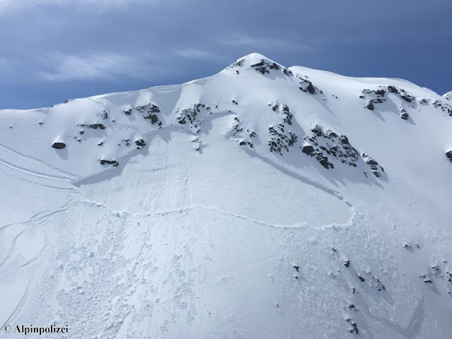
Avalanche Lüsener Spitze

Above the fracture, entry track is visible, beneath that, exit track. Lüsener Spitze, 3100 m, northeast.  (photo: 03.05.2020)

Avalanche eastern Daunkogel

On 3 May, 5 winter sports enthusiasts were below the northern gully leading up to the eastern Daunkogel. During the ascent a slab avalanche triggered, from which 4 of the group were able to escape. One person was partly buried in snow. All persons remained without injuries. The avalanche released at about 3250 m on an extremely steep north-facing slope. The length of the avalanche was about 700 m, width 250 m, fracture depth generally 30-50 cm.

Photo taken prior to the avalanche when 5 persons were in the ascent towards the eastern Daunkogel (red circles). (photo: 03.05.2020)

Photo taken just after the avalanche. (photo: 03.05.2020)

Aerial photo of avalanche on eastern Daunkogel taken by Alpine Police. (photo: 03.05.2020)

Photo taken at orographically left avalanche fracture. The red arrow indicates the weak layer relevant to release: faceted crystals beneath a thin melt-freeze crust. (photo: 04.05.2020)

Snow profile detailed view. Red arrow points to weak layer. Avalanche fracture was 35 cm deep at this point.

Cause of avalanches

The cause of the avalanche releases lies in the weak layers which formed just prior to the occurrences and were the immediate result of variable weather conditions.

Data from relatively high-altitude station on Pitztal Glacier help to pinpoint cause: variable April weather. Ongoing temperature fluctuation, repeated bouts of snowfall, strong winds (esp. from 1 May, enhancing formation of slab above weak layers). Decisive for the avalanches was the snowpack moistening on 27-28 April, subsequently it cooled due to snowfall. Great temperature variations reinforced metamorphism (danger pattern 4: cold on warm).

As comparison: Breiter Grieskogel station. The gray line in the second graph depicts the snowpack surface temperature, initially at zero degrees (thus, moist) then repeated leaps as temperatures tended lower, with fresh snow deposits on top.

Recent precipitation in Tirol

 Typical mixture: sunshine, clouds, precipitation

Precipitation often stemmed from convective clouds, i.e. similar to thunderstorms with powerful, vertical air currents. In such conditions, graupel often forms (in summertime, hail). If graupel is amply deposited it can form a weak layer when snow covers it.

Graupel on the surface in Defereggental (photo: 03.05.2020) 

Below, comparative shots of the northern aspect of Rietzer Grieskogel, taken from Inn Valley, also showing that weak layers causing these slab avalanches were relatively recent.

Photo from 23 April when, amid dry air masses, not a single slab avalanche but several loose-snow avalanches were observed. Also where the red circle is. 

Photo from 3 May: near the encircled zone of the photo above, a superficial slab triggered below a cornice.

UPSHOT

Near-to-surface weak layers can currently be triggered by winter sports enthusiasts above about 2800 m on very steep north-facing slopes. In other aspects, we assume that increased solar radiation has already dispersed potential weak layers, that they are relevant only in high alpine terrain (around 3500 m).  We unfortunately have no assured data from that altitude/terrain. Future developments of weak layers depend on weather conditions. If temperatures rise significantly, the weak layers could be destroyed quite rapidly; on the other hand, faceted snow crystals could persist for awhile.

Other news:

According to latest registered amounts of fresh snow (5 May), numerous loose-snow avalanches can be expected tomorrow on 6 May.

Loose-snow avalanches in extremely steep terrain  (photo: 03.05.2020)

Caution: cornices! (photo: 03.05.2020)

Marmottes awakening from hibernation  (photo: 03.05.2020)

The slopes are rapidly becoming bare of snow.  (photo: 03.05.2020)

The next update of this blog will be published as soon as there is a significant change in the snow/avalanche situation in Tirol’s mountains.

Friday 1 May 2020

April ends unstably: more high-altitude loose-snow avalanches

April ends, April weather starts

The unusually long period of fine weather including extremely low in precipitation came to an end last weekend starting on 25.04. Since then, variable April conditions have reigned, with the long awaited precipitation.

Last weekend: ongoing shuffle of sunshine, clouds and precipitation. Griesskogel Group (photo: 27.04.2020)

Precipitation on 28-29 April, most of it in the northwestern regions

Variable weather conditions, repeated bouts of precipitation. Lower temperatures brought a bit of snowfall down to intermediate altitudes. Hahnenkamm station in Ausserfern

A similar situation in northern East Tirol

Effects on the snowpack

Snow melt continues, slowed down currently by the cool air masses. Thus, generally no snow at low and intermediate altitudes.

Down below, no snow. Higher up, little and/or sufficient snow. (photo: 23.04.2020) 

Starting at about 1700 m there is some fresh snow, including a “slight breath of powder” with ascending altitude, according to ambitious backcountry ski tourers. That powder is more or less destroyed (moistened) by diffuse radiation. Beneath the fresh snow (at least below 2500 m) stable summertime corn snow is often found.

Stable ‘summer-firn’ in the Stubai Alps (photo: 23.04.2020)

Persistent weak layers inside the snowpack from mid-winter are unlikely to trigger, conceivable (judged from afar) on very steep shady slopes where the snow is shallow at 2500 to 2800 m. Particularly shady slopes at altitudes around 2700 m snow are in the initial phase of being thoroughly wet, evidenced by simulation models. In high alpine zones (above 3000 m) fresh powder might form a weak layer for a short spell, particularly where there was more snowfall with little wind influence followed by solar radiation bonding the uppermost layer, thus generating a ‘slab’.

Main danger: loose-snow avalanches

Fresh snow reacts very swiftly to the impact of warmth and solar radiation in this season. That means that for a very short time following snowfall, numerous moist/wet loose-snow avalanches can be expected in extremely steep terrain. Precisely that was observed on 30.04 where conditions in outlying terrain resembled a sauna. Slab avalanches and glide-snow avalanches, on the other hand, were rare. In isolated cases small slab avalanches were triggered in the wake of loose-snow avalanches. Glide-snow avalanches have probably released already for the most part. Nevertheless, in rare cases they cannot be ruled out on smooth (mostly grass-covered) ground at high altitudes.

Arrows show some of the loose-snow avalanches that released in the Northern Massif above Innsbruck on 30.04.

Nearly all avalanche deposits are from loose-snow avalanches. As a consequence, small slab avalanches were also triggered (encircled). Potential danger stems from cornices breaking.

More precipitation coming: main danger remains loose-snow avalanches

Here is what the forecasts predict for the next few days: it will remain cool, some snowfall in the mountains (most in the west and along Main Alpine Ridge). Due to a quite stable old snowpack, loose-snow avalanches continue to be the main danger.

Forecast of fresh snow and wind in the central Stubai Alps

Fresh snow predictions for the coming days

A huge debt of thanks

We would like to extend an enormous vote of thanks to all those who have supplied us with so much valuable information over the winter season.

Blogs will be published as the situation requires, if the snow and avalanche situation in Tirol’s mountains changes significantly.