Friday, 10 December 2021

Complex and accident-prone avalanche situation

The situation goes on: winter sports enthusiasts advised towards special caution and restraint!


Trigger-sensitive snowpack

The current weather forecast (wind, snowfall and a warm front coming on Sunday, 12.12) combined with the current snowpack layering make it clear: the situation will stay tense for winter sports enthusiasts. We swing back and forth in danger evaluations between a “Skiers’ High” and a “tense danger level 3” (considerable danger) above the timberline.

This is due to very unfavourable snowpack layering over widespread areas, as we talked about in the last blog. Inside the snowpack there are several potential weak layers which can trigger avalanches even by the weight of one single person.


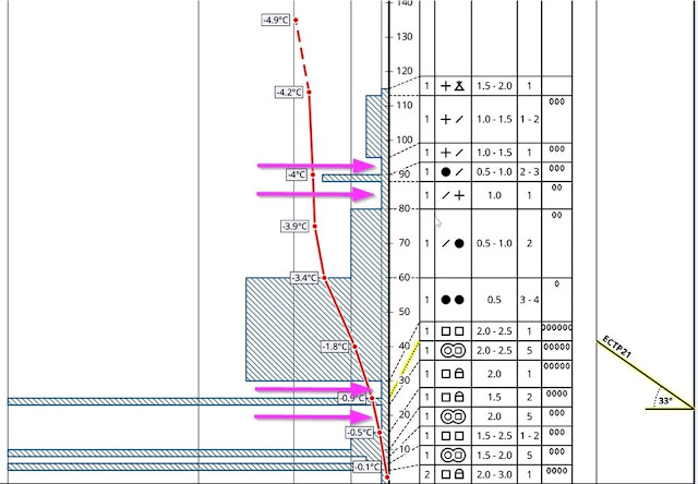
Die Pfeile zeigen auf die aktuell wahrscheinlichsten Bruchstellen innerhalb der Schneedecke hin. Diese findet man bevorzugt an Übergängen von dünnen weichen und harten Schichten. In Oberflächennähe bestehen die Schwachschichten häufig aus lockerem Pulverschnee (z.T. handelt es sich um Wildschnee), manchmal auch vermengt mit Graupeleinlagerungen. Tiefer in der Schneedecke handelt es sich um lang anhaltende, aufbauend umgewandelte Schwachschichten, die sich während des Frühwinters (insbesondere während der langen Schönwetterperiode im November) gebildet haben. Profil vom 08.12.2021, 1965m, Nord. Galtjoch, Östliche Lechtaler Alpen
Arrows point to the current likely fracture spots inside the snowpack. They are found particularly in transitions zones from thin, soft layers to hardened layers. Near the surface the weak layers are often loose powder (“champagne powder”) but also mixed with layers of graupel. Deeper down in the snowpack there are long-enduring faceted weak layers which formed in early winter (especially during a period of beautiful weather in November). Profile on 8.12.2021, 1965m, north. Galtjoch, eastern Lechtal Alps


Expansively metamorphosed weak layers are fond wherever the snowfall at the end of November stayed on the ground. This occured especially on shady slopes above the timberline and on sunny slopes at high altitudes. Surface (blanketed) weak layers of loosely-packed powder are currently found in all wind-impacted areas, and in all aspects, particularly above the treeline.

While surface-near layers are currently easy to trigger, stability tests show that the deeper layers of faceted crystals demonstrate a gradual trend towards reduced proneness to triggering, but the fracture propagation is still high. What that means is that avalanches can still fracture down to more deeply embedded layers of the snowpack. The possible avalanches can thus grow to dangerously large size in regions where snowfall has been heavy, thus making them perilous for winter sports enthusiasts.


Cracks and settling noises when stepping onth the snowpack have been a daily occurrence since 1 December. In the interim, they occur slighly less often, but they still signal loud-and-clear that the snowpack is unfavourable and prone to trigger. Arlberg region (photo: 01.12.2021)


Variable weather


Sehr wechselhaft: Immer wieder Schneefall, Wind aus wechselnden Richtungen sowie ein Auf und Ab bei den Temperaturen. Station Grubigstein in den Östlichen Lechtaler Alpen
Highly variable: repeated bouts of snowfall, wind from changing directions, and fluctuating temperatures. Station Grubigstein in the eastern Lechtal Alps


Die vergangenen Niederschläge vom 08.12. auf den 09.12. konzentrierten sich v.a. auf den Westen und Süden des Landes und fielen etwas geringer aus, als ursprünglich vorhergesagt.
The most recent round of precipitation on 8-9 December focused on western and southern parts of Tirol, brought somewhat less than originally anticipated.


The weather will remain variable, at least through the weekend. Repeated bouts of snowfall, sometimes strong-velocity winds, and on Sunday/Monday (12.12 - 13.12) a warm front will bring rainfall at least up to intermediate altitudes. Everything points in the same direction: the situation will stay tense, on the contrary, at least on the night of 12.12 it is expected that avalanche danger levels will increase (again).


Die vergangenen Niederschläge vom 08.12. auf den 09.12. konzentrierten sich v.a. auf den Westen und Süden des Landes und fielen etwas geringer aus, als ursprünglich vorhergesagt.
Windblown zones next to wind-loaded zones, a sign of recent wind impact. Nockspitze, northern Stubai Alps (photo: 08.12.2021)


(Isolated) naturally triggered avalanches possible

As a result of strong winds being forecast, isolated naturally triggered avalanches are still possible. What seems most important in this connection is that the current snow depths are not sufficient for large, damage-causing releases. We anticipate more naturally triggered avalanches after the warm front passes through, starting on Sunday, 12.12.

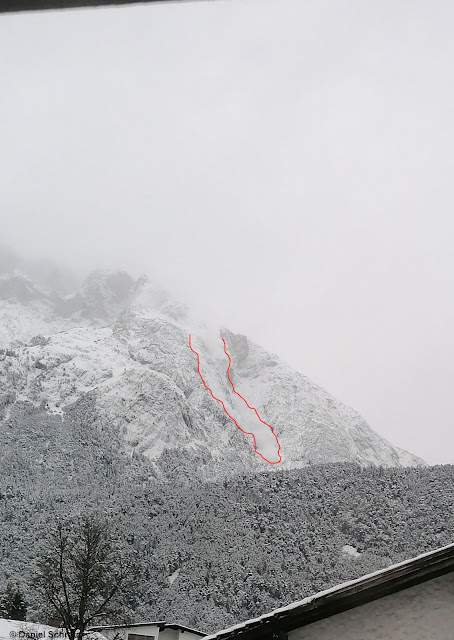
Foto einer von der Hohen Munde im Mieminger Gebirge gerade im Staub abgehenden Lawine. Lawinengröße im Anrissbereich vermutlich mittelgroß. (Foto: 09.12.2021)
Photo from the Hohe Munde in the Mieming Massif as an avalanche tosses up a cloud of dust. In the fracture zone the avalanche was presumably medium-sized. (photo: 09.12.2021)


Caution: gliding snow on steep, grass-covered slopes

In the regions where snowfall has been heaviest during recent days there is increased activity of glide-snow slides and glide-snow avalanches. This was the case particularly at low and intermediate altitudes. 

Gleitschneeaktivität in den Südlichen Zillertaler Alpen (Foto: 06.12.2021)
Glide-snow activity in the southern Zillertal Alps (photo: 06.12.2021)


More favourable: low wind-protected zones

Whoever wants to head into backcountry over the next few days will find low-altitude zones where on the one hand there was no wind impact, and on the other, where the snow on the ground did not persist until 26 November, which means there is no glide-snow problem. That means: quite good conditions.
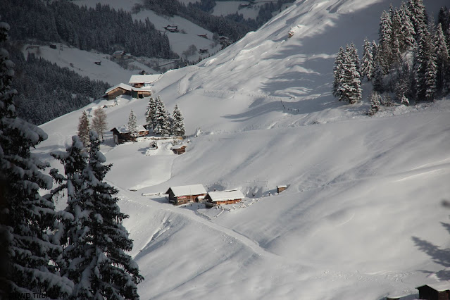

In tieferen Lagen herrschen vergleichsweise recht gute Bedingungen. Tuxer Alpen (Foto: 07.12.2021)
At low altitudes, conditions are significantly better in general. Tux Alps (photo: 07.12.2021)


Our appeal

Dangerous zones above the treeline are currently quite difficult to see with the naked eye, even for experienced backcountry winter sports enthusiasts. Worse still, they are very widespread. Defensive conduct of the winning bid of the moment. Inexperienced persons are strongly advised to remain on the secured ski slopes until further notice.

Caution: danger zones are also located in the immediate vicinity of secured public ski slopes!

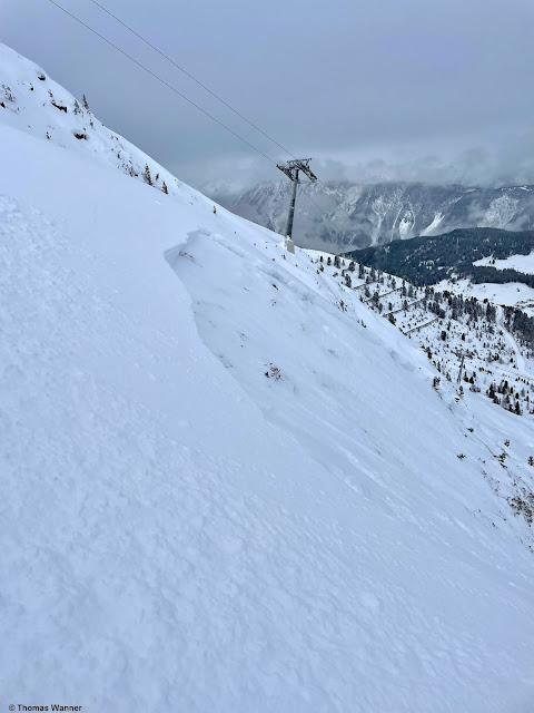
Lawinenabgang aufgrund einer Fernauslösung im unmittelbaren Nahbereich einer Piste im Skigebiet Hochötz (Foto: 05.12.2021)
Avalanche released by remote triggering in the immediate visinity of a piste, Hochötz Ski Area
(photo: 05.12.2021)