Friday 27 December 2019

Peak of avalanche danger has passed. Main perils: high-altitude snowdrifts, gliding snow below 2600 m

An intermediate high on Boxing Day brings the stormy bouts of snowfall forecast by ZAMG Weather Service to a close. The apogee of avalanche danger is now been passed, over the next few days, avalanche danger will incrementally diminish. The main problems: fresh and older snowdrift accumulations at high altitudes, on the one hand; gliding snow masses over steep, grass-covered slopes, on the other. The warm, sunny weather expected to start on 28.12 will reinforce gliding snow.

Overview of precipitation

The forecasts of the ZAMG Weather Service were fulfilled precisely. Most of the snow fell in the furthermost western regions, as well as in the northern Regions of Tirol. The snow station on the Seegrube above Innsbruck won the prize for maximum precipitation.

Overall snow depths at the Seegrube station have increased by more than 150 cm since 21.12.

The 72-hr forecast of new snow for 23 - 26.12.2019 for Tirol and immediate surroundings.

Deep winter at the Alpl hut in the Mieming Massif at 1540 m (photo: 25.12.2019)

Ski-run vehicles battling with 60 cm of fresh snow on Tiefenbach Glacier on 25.12.

Generally storm-strength winds were typical of East Tirol in general. Precipitation fell especially on 21.12 (further south even more).

Typical of East Tirol: station St. Veit Zischke in Defereggental.

Some fresh fallen snow, but most of all, snow reserves from mid-November: on the path to Taishörndl in Villgratental (photo: 22.12.2012)

The snowpack

The fluctuating temperatures during the most recent period of precipitation led to a vascillating snowfall/rainfall level: for a brief spell on 24.12 at 1800 m, before dropping frequently to 1000 m on 25.12. Due to previous warm weather, a slightly moist or isotherm snowpack can be assumed above about 2000 m. In addition, we see lots of graupel kernels inside the fresh snow, but no unified or pronounced layer for slab avalanches. Nevertheless, greater nests of graupel from place to place, which would encourage slab avalanches, cannot be ruled out (especially below rock falls).

Isotherm snowpack, graupel in the upper part. Mieming Massif  (profile from  25.12.)

Similar conditions in Lech, just across the Tirolean border: a thin melt-freeze crust formed near the surface from a previously rain-impacted layer. 


What matters most at the present juncture are not the embedded patches of graupel, but the faceted layers near the melt-freeze crusts on sunny slopes above 2400 m (somewhat higher on south-facing slopes, presumably above 2600 m). Avalanches can trigger particularly in transition zones from shallow to deep snow in very steep terrain, frequently only by large additional loading.

A potential weak layer for slab avalanches could also exist in the fresh fallen, now blanketed powder snow.

Fresh snowdrifts require caution, especially near ridgelines on shady slopes. (photo: 26.12.2019)

Regarding the danger pattern (dp.4) referred to in the last blog, it seems that no significant weak layer has formed to date. The forecast temperatures seem to have halted this process.

Also widespread: snow padding. Rietzer Grieskogel  (photo: 26.12.2019)

The snow cover frequently shows pronounced effects of wind. Zillertal Alps. (photo: 26.12.2019)

Avalanches that released

Numerous observer reports reached us on 26 December with the following picture: frequent naturally triggered avalanches on 24.12 in the latter part of the day; for example, a naturally triggered avalanche from the rear Kaunertal which plummeted all the way to the valley floor. In the rear Ötztal, reports of naturally triggered avalanches which have been blanketed in the interim. All in all, the number of naturally triggered avalanches throughout Tirol seems to have been rather limited.

Avalanche in Ferwalltal (fracture zone appx. 2800 m, north) (photo: 26.12.2019)

Artificially triggered avalanches (through explosives) had widely varied results: some generated positive effects, others didn’t trigger any avalanches.

Explosives triggered these avalanches in the Sölden ski area, adjacent to ridgelines, NE, 3200 m (photo: 26.12.2019)
Another slab avalanche triggered by explosives - Wilde Grube, Stubai Glacier (photo: 26.12.2019)

Avalanches involving persons

Tirolean headquarters reported several avalanches on 26 December involving persons. They caused only minor injuries.
Here a summary:

- Pürgleslenke in Innervillgraten
- Schleinitzmulde in the Schober Massif
- Wasserkar - Gaislachkogel in Sölden ski area, south, 2900m
- Schwarzkogel in Sölden ski area
- Red ski run no. 38 Ischgl - Silvretta Skiarena

Avalanche on Schwarzkogel, E/SE, 2850 m. A person (not depicted) was thrust against the snow shed  (photo: 26.12.2019).

We were also informed of an avalanche triggered by a ski-slope vehicle in Paznauntal. No one was injured.

Avalanche releases of the last few days can also be found here: 

Avalanche on the Diritissima of Hafelkar above Innsbruck on 24.12, south, 2200 m

Increasingly relevant: glide-snow avalanches

Glide-snow avalanches will be more frequent during the coming days. This is due to anticipated rising temperatures and the increasingly wet snowpack.

Glide yaw in the foreground, glide-snow avalanche in the background, Paznauntal (photo: 26.12.2019)

Avalanches in the Northern Massif: the red line traces the open fracture of a glide-snow avalanche. Loose-snow avalanches released at the spots marked by arrows. The magenta-colour marks a slab avalanche, somewhat covered by fresher snow. (photo: 26.12.2019)

A latent threat: gliding snow in southern East Tirol (photo: 26.12.2019)

Frequently observed: gliding snow on shady slopes below 2000 m. Ausserfern. (photo: 20.12.2019)

What’s next?

On 27.12 skies will be heavily overcast in North Tirol and northern East Tirol, accompanied by a small amount of snowfall (rainfall below 600-1000 m). At high altitudes, brisk NW winds will be blowing. Subsequently, according to latest ZAMG Weather Service forecasts, a powerful high-pressure zone will prevail. Temperatures will rise. A still strong-velocity northerly wind will be blowing in East Tirol in particular, subsequently slacken off.

These anticipated weather conditions will have a positive effect on avalanche danger levels. But the risk of glide-snow avalanches will tend to grow larger over the next few days.
Joys of powder snow, Niltal, East Tirol (photo: 24.12.2019)

Starting 28.12, fine weather like in the photo of Langschneid in Defereggental is anticipated  (photo: 26.12.2019)

Wednesday 25 December 2019

A Christmas present – new things in the avalanche report

Last winter the cross-border Internet website of the Euregio Avalanche Bulletin was launched. The enormous extent it was accessed, together with 3500 reader feedback reactions in the online survey at the end of March 2019, confirm the high degree of acceptance of the site. In addition we received lots of stimulating suggestions and proposals for improvements which our team has now implemented.

Here is a brief overview of the most important improvements:

Better depiction of daytime changes

Whenever avalanche dangers change within one day, two maps are shown, one for morning, one for afternoon. That already existed last winter. What’s new is displaying both danger maps on the home page. Previously you had to switch from morning to afternoon. Now it immediately jumps to view that the situation will change during that day. In addition, a leaner table of contents makes the map more prominent, provides a quicker overview.


Reports of all endangered regions are immediately online 

As soon as the user accesses the site, reports of endangered regions are immediately available. If clicking on the map is not possible, e.g. if Internet connection is poor, the reports can still be read. Simply scroll or pan.


Weather stations and their data

In Tirol, our technician Paul Kößler is in charge of the dense network of automated measurement stations. This year he established several new stations: Nauders-Ganderbild; Predigberg-snow station; Kappl-Spiduralpe; Axamer Lizum. In addition, he supervises approximately 200 other locations in Tirol. The latest data from all these stations are available to users directly in the avalanche report. What’s new is the access to the stations: now easily clickable in the “snow & weather” section of the contents via links integrated into weather maps and the newly designed list of station measurements.

Access the values in the weather maps by clicking the graph of this weather station.

The new weather-station measurement table. By clicking the station name, you access the graphs of that station.

A weather-station graph example. Display of current measurements includes possibility to select various times-of-day

Also improved was data quality with the help of an automatically integrated correction of apparent snafoos. Even though we have reached a very high status of reporting accuracy, occasional errors are part of the human scenario.

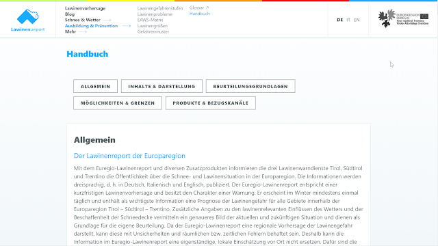
Handbook 

For all those who would like to know more about the Avalanche Bulletin and other related products, we recommend the new handbook. It is listed in the menu under “Education & Prevention”.

The menu item “Handbook” accesses a complete description of the Avalanche Bulletin.


Information even if Internet connection is poor

If you click https://lawinen.report/simple/de.html, a simplified version of the Avalanche Bulletin can be accessed swiftly in case Internet connection is poor. That gives users the guarantee of having full info of the snow and avalanche situation even in isolated regions where Internet coverage is weak.
A simplified depiction of the Avalanche Bulletin, in case Internet coverage is weak.

In addition, the new system reacts automatically to poor Internet coverage, enabling you to instantly switch to the simplified version.


New possibilities to replace WhatsApp

Subscribers to the Avalanche Bulletin have already been notified that the report is no longer available via WhatsApp. This is due to company policy regarding this service. To replace it, we have arranged alternative channels to access the bulletin. This video show just how it works:(https://www.youtube.com/watch?v=MSbS-vUad-w):


We wish all our readers and users of the Euregio Avalanche Bulletin: Happy Holidays and accident-free backcountry tours.

Monday 23 December 2019

Stormy NW air current bringing heavy snowfall regionally, plus rain. Avalanche danger increasing!

Precipitation, winds, temperature fluctuations

The persistent southerly air current with precipitation along the Main Alpine Ridge and in East Tirol has been replaced by a NW air current. The ZAMG Weather Service warns of snowfall and rainfall between 22.12 6:00 pm and 25.12.2019 6:00 pm, most of which is expected to fall in the Silvretta, Arlberg and Allgäu/western Lechtal Alps: 100-150 cm, more from place to place. From the eastern Lechtal Alps over the Karwendel to the Wilder Kaiser, 70-100 cm is expected, with local deviations above that. In the rest of North Tirol and northern East Tirol, amounts between 30 and 80 cm are expected.


On Hydro Online, it is easy to recognize the 24-hr precipitation in Tirol (cutoff point: 23.12.2019 at 12:30 pm):

Most of the precipitation is expected in the northern and northwestern regions. Here the example of Muttekopfhütte Refuge, where 50 cm of snowfall has already been registered. Stong winds, the shift of wind direction and the descending temperatures are easily recognizable.

What matters most for the avalanche situation are not the great amounts of fresh snow, but the temperature fluctuations. After a cold front on 23.12 (snowfall level 800-900 m) there followed a warm front on 24.12 (snowfall level: about 1700 m) which was subsequently replaced by a cold front (snowfall level at 1000 m). This precipitation was accompanied by storm winds in the mountains.

The stripes in dark green: forecast of precipitation and temperature fluctuations in Kaiser and Ausserfern (“Heute” refers to 23.12.2019).

Rising avalanche danger

All these factors combined lead to rising avalanche danger. We expect the highest naturally triggered avalanche activity with the warm front passing through on 24.12 . Rainfall will weaken the snowpack at low and intermediate altitudes. Subsequently, numerous glide-snow avalanches will be observed on steep, grassy slopes, also wet, loose-snow avalanches in rocky terrain in the areas where snowfall has been heaviest. At higher altitudes where there has been snowfall, more frequent slab avalanches will trigger naturally.

Thoughts about snowpack structure

As regards avalanche magnitude, we have the following considerations. Possible weak layers for slab avalanches are currently found inside the old snowpack in E/S/W aspects beginning at about 2300-2500 m and upwards. These are faceted layers near melt-freeze crusts which have been generated quite near to the upper surface of the old snowpack. Such areas are not area-wide. Fractures which are generated due to the burdens on the snowpack are not expected to propagate over widespread areas of the terrain.

An additional possible weak layer inside the mass of fresh fallen snow: the new fallen snow at cold temperatures in wind-free zones. When the warm front passed through, the higher temperatures formed a superficial “slab” which can easily be disturbed atop the loose and cold snow. The slab will become deeper through additional snowfall. Higher proneness to triggering thus persists, even while the cold front passes through and at least until the following day, 26.12.

In addition, one more development inside the snowpack occupies us. This is Danger Pattern 4 (cold on warm). The moist old snowpack surface until 20.12 at low and intermediate altitudes and on sunny slopes up to at least 2500 m was covered by cold snow on 20.12. Due to temperature variations on the borderline surface of these two layers, a faceted weak layer could form, with some delay. Currently there is no information which indicates that this layer is sufficiently pronounced to generate avalanches, this is expected only in altitudes above the timberline.

The red perpendicular line and the arrow symbolize the possible start of danger pattern 4 formation (cold on warm).


Okay, to try to complete the circle: avalanches will be generally of medium size, but in the major areas of precipitation often large-sized (very large avalanches are expected to be the exception. If at all, then in the regions where snowfall has been heaviest in leeward, high-altitude and ridgeline starting zones, i.e. below rock walls).

Interim high pressure influence on Thursday, 26.12.  Restraint is called for!
According to ZAMG Weather Service forecasts, conditions on 26.12 should improve in an interim high. The first day of beautiful weather after a period of storm winds and snowfall is especially prone to accidents. For that reason we recommend a great deal of restraint in outlying terrain. Avalanche prone locations are widespread in the areas where snowfall has been heavy.

Thursday 19 December 2019

Limited danger zones, generally poor snow quality

Last week bore the imprint of southerly air currents. At high altitudes, lots of snow was transported. The freshly generated snowdrift accumulations were easily triggered to start with. The unseasonably mild temperatures then improved the situation. The main problems this week were small glide-snow avalanches and moist slides, also distant-from-ridgeline snowdrifts at high altitude and a diffuse old-snow problem on sunny slopes above about 2500 m.

Weather conditions and a brief outlook

The Alps received the brunt of a cold air thrust from the Atlantic in a powerful SW air current. With this, mild and dry air masses were pushed towards Tirol. Subsequently the high-altitude air current shifted to southerly and intensified, which brought about a mighty foehn syndrome.

Wide-ranging snow transport on 14.12 in far reaching parts of Tirol. Stubai Alps
The foehn current will persist until Friday, 20.12, then be replaced by a cold front on Saturday, 21.12. The cold front will terminate the foehn and bring us variable and cooler weather conditions.

Striking: very mild temperatures, lots of wind, variable conditions.

Forecast of fresh snow til 21.12. Then additional snowfall will come to Tirol. Temperatures will drop.

Currently, on 19.12: rainfall in southern regions. Snowfall level at 2000 m.

The snowpack

Last week was taken up by intensive snowpack analysis, also in the context of an avalanche commision course in Galtür. With support from helicopters, also government issue, we were able to concentrate on potential problem zones.

En route with the government helicopter. Grosstal  (photo: 19.12.2019)
Upshot: the snowpack is highly irregular over widespread areas, massively affected by winds at high altitudes, generally moist up to at least 2200 m (especially at ground level and on the upper surface). On sunny slopes, we found a series of melt-freeze crusts and faceted crystals, potential weak layers for slab avalanches, especially above 2500 m. Such avalanche prone locations are currently rather diffuse, tend to be of limited distribution.

On west-facing slopes we found the worst snow profiles.
Generally in the encrusted zones, no thoroughgoing fractures could be generated.

Highly irregular snow distribution. Heavy wind impact. Silvretta  (photo: 18.12.2019)
The snow quality is poor over widespread areas.

En route to the Sulzkogel (17.12.2019)

Indication of a thoroughly wet snowpack  (photo. 17.12.2019)

In many places (excluding in southern regions) little-to-no snow at low altitudes. Kitzbüheler Horn  (photo: 19.12.2019)

Release avalanches

This week, there were three avalanches in which persons were involved.

Avalanche release in Sulztal. West, appx. 2500 m. One person was swept along, but could escape with injuries. Apparent old-snow problem.

Avalanche just below Lampsenspitze. No one was buried. Material loss.  (photo: 15.12.2019)

Below the rocky fundament of the Schneiderspitze in the Axamer Lizum, two ice climbers triggered a slab avalanche.  North, 1900 m, very steep.  (17.12.2019)

Elsewhere several avalanches were triggered by persons who were not buried by them. Freshly generated snowdrift accumulations atop loose snow layers. Stubai glacier  (photo: 13.12.2019)

Especially in NW regions, increased gliding snow activity. Ausserfern  (photo: 15.12.2019)

It is getting more wintery

As mentioned above: it is getting more wintery. To start with, from the south, subsequently from W/NW air currents are being funneled to Tirol which presage precipitation. To start with, most of the precipitation is expected along the Main Alpine Ridge from the Ötztal Alps eastwards, and in the southern part of East Tirol. Then, as the air current shifts, the precipitation will spread, but least of all to the northeastern regions. The old-snow problem referred to above will worsen with this burden of snow. Elsewhere, fresh snowdrift accumulations require increased heed. We also have a latent glide-snow problem