Alarm signals – take them seriously!
This year’s seasonal launch is a corker. Following the last two significant rounds of precipitation (26-29.11 and 30.11-01.12) avalanche danger levels shot up considerably, just as forecast. We are in the uppermost reaches of Danger Level 3 (Considerable), very close to the level known as “Skiers’ 4” with very high likelihood of avalanches triggering in some regions.
The weak layers described in an earlier Blog have now been blanketed by a snowpack with marked influences of wind and warmth. (This is the bonded snow necessary for a slab avalanche: the slab.) This slab is monumental, due to the warm front which struck during the night of 30.11 to 01.12. For that reason there are currently countless traps waiting to be sprung, for example by the weight of skiers.
Alarm signals such as naturally triggered avalanches, remote triggerings, glide cracks and settling noises (‘whumpf’ noises), but also avalanches involving persons and successful artificial triggerings have been everyday occurrences recently...and still are. Naturally triggered avalanches were especially frequent during the night when the warm front passed through (30 November - 1 December), weakening the snowpack so massively. Avalanches involving persons were more frequent during yesterday’s window of fine weather (1 December). In the last few days, other red flags also began waving at us, some of which we observed outselves. In addition, current snowpack analysis in the neuralgic regions (particularly where recent snowfall fell on an old snowpack) demonstrate an extremely high proneness of the snowpack triggering with high fracture propagation.
 |
| Snowpack analysis, Arlberg region near the Galzig. The block of snow in the foreground released with minimal provocation (propagation saw test). Other stability tests throughout the land produced similar results. (photo: 01.12.2021) |
Avalanche releases involving persons
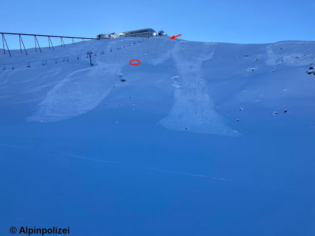
Avalanche Hoadl, Kalkkögel, (Stubai Alps) on 01.12.2021
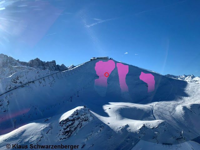
On 1 December two persons skied into the 35° steep slope in NE aspect at about 2270m just below the Hoadl mountain station and triggered a slab avalanche. One person was able to ski out of it, the other was swept along, was able to activate the avalanche airbag, got partially buried, emerged with only an injured ankle, and was flown to the hospital in helicopter C1.
 |
| Avalanche Hoadl. Photo taken in C1 helicopter’s landing approach. Encircled: the spot where the injured person was buried. The avalanches orographically to the left were probably secondary remote triggerings. (photo: 01.12.2021) |
 |
| Avalanche Hoadl with entry tracks on the slope and spot of burial. (photo: 01.12.2021) |
Avalanche Gamsgarten, Stubai Glacier, (Central Stubai Alps) on 01.12.2021
Immediately bordering Piste No. 3 towards Gamsgarten, two winter sports enthusiasts skied into a steep (36° gradient) NE-facing slope. One person was completely buried (snowboard poked out of the snow) and the second person partially buried. Both could be rescued without delay but were flown to the hospital as a precaution. Our latest information tells us they were not hurt.
 |
Avalanche Gamsgarten. North, 2450m, 36°. Just to be sure, the avalanche wedge was probed.
(photo: 01.12.2021) |
Avalanche Naviser Kreuzjöchl, (western Tux Alps) on 01.12.2021
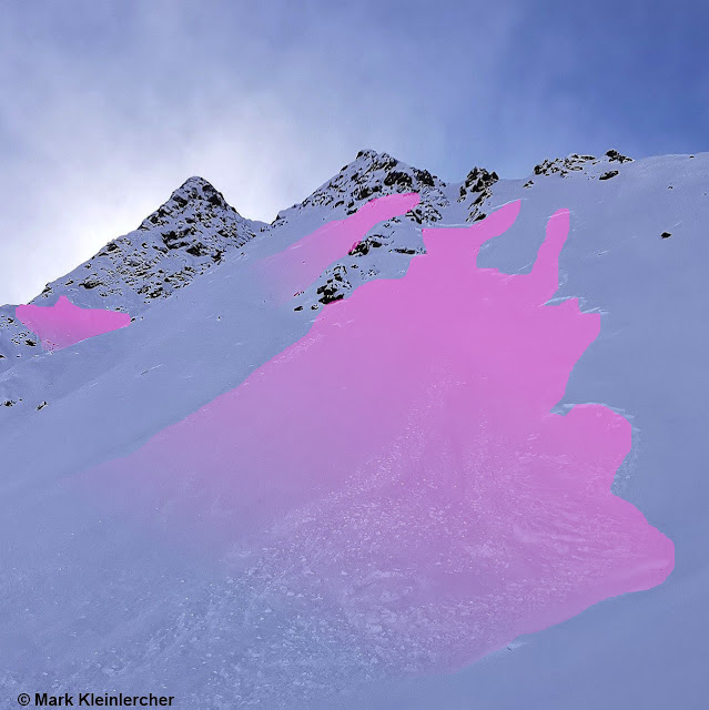
Just below the summit of the Naviser Kreuzjöchl at about 2450m a slab avalanche triggered when a single backcountry tourer skied into the very steep slope. The person was swept along by the slab avalanche and lost a ski stick, but was able to ski out of the avalanche without injuries.
 |
| Avalanche Naviser Kreuzjöchl. Arrows point to entry and exit tracks. The colored zone is an additional slab avalanche in the same aspect and altitude, an obvious alarm signal... (photo: 01.12.2021) |
Avalanche near women’s descent on Hoadl, (northern Stubai Alps) on 01.12.2021
 |
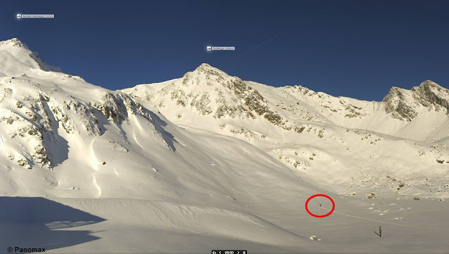
| Web camera photo on Hoadl towards the south. Jörg Randl of the Alpine Police circled a skier...see next photo -> (photo: 01.12.2021) |
 |
| In this photo taken 10 minutes later, the slab avalanche is visible. The person was able to escape it without injury. (photo: 01.12.2021) |
Here are some interesting pictures of avalanches where persons were at least in the immediate vicinity.
 |
| Web camera photo in Kühtai towards Pirchkogel (northern Stubai Alps). A person can be seen ascending...see next photo -> |
 |
| The same person is encircled in this photo. Avalanches are visible in the foreground, probably remotely triggered since the terrain is not at all steep. (photo: 01.12.2021) |
 |
| Same area as the two above photos. Fracture propagation seems to have reached the rearmost cavity. Orographically right of the saddle, another large avalanche fracture is visible. (photo: 01.12.2021) |
 |
| Alexander Blümel drew our attention to this webcam photo near the Drei-Seen Lift in Kühtai. Persons are visible near a freshly released slab, doubtless remotely triggered. (photo: 01.12.2021) |
 |
| In the descent from the Lampsenspitze, northern Stubai Alps. In the shady zone above the skier to the right, glide cracks in the snowpack indicate fracture propagation. (photo: 01.12.2021) |
 |
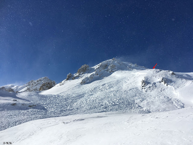
| Arrow points to a skier, all around whom a slab triggered. Pfoner Kreuzjöchl, 2520m, East |
Naturally and artificially triggered avalanches
Both in East Tirol and in North Tirol numerous reports came in about avalanches. Most of the releases occurred during the evening hours on 30 November.
 |
| Naturally triggered slab avalanche in Ausserfern (photo: 01.12.2021) |
 |
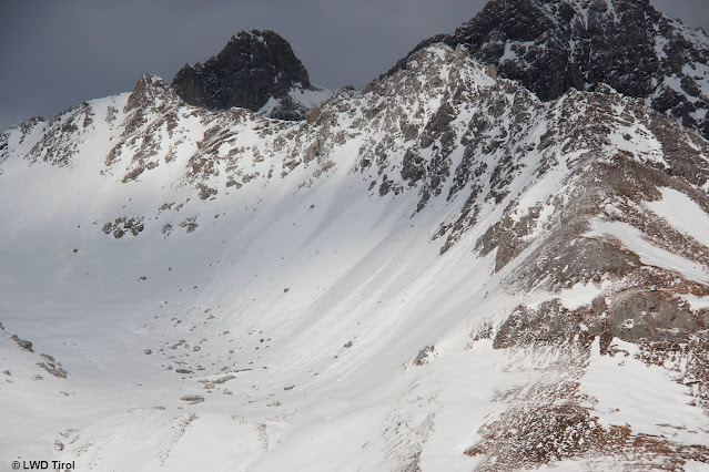
| Naturally triggered slab avalanches. Langschneid, Defereggental (photo: 29.11.2021) |
 |
| One of the very successful artificial triggerings with explosives: Rendl am Arlberg. The explosive is encircled. (photo: 01.12.2021) |
Far less worrisome than slab avalanches are the glide-snow and loose-snow slides which we also observed.
 |
| Encircled: numerous glide-snow slides on steep grass-covered slopes in Ausserfern (photo: 01.12.2021) |
 |
| Loose-snow slides in extremely steep terrain. Also visible: massive wind influence during the recent snowfall. Arlberg region (photo: 01.12.2021) |
Weather review and outlook
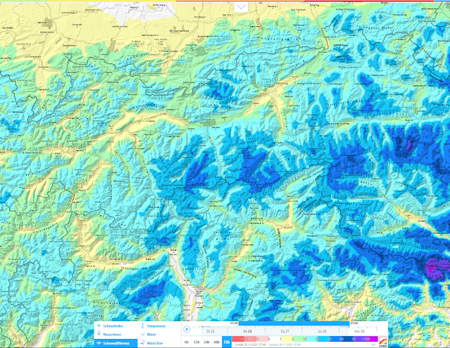
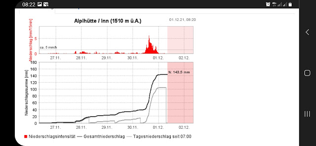
For a better grasp of recent weather developments, here are some clarifying maps and graphs.
 |
| 72-hour snow difference 26.11.-29.11 – particularly the southeastern regions. |
 |
| 72-hour snow difference 29.11 - 02.12.2021– particularly northern and western regions. The actual values are under-represented since the snowpack settled well starting on 1 December. |
 |
| Maximum measurement during recent precipitation: Alphütte station, Mieming Massif. |
 |
| Highly instructive: continuous increase in snow depths even including the subsequent diminishing and settling of the snowpack during the massive warming. Often stormy winds in the mountains. Temperatures have dropped, winds slackened off, in the interim. |
The weather outlook in brief. Highly variable conditions will persist, air temperatures continually rising and falling, repeated bouts of precipitation without any certainty about how much. Following a fine-weather day on Friday 3 December and star-studded nighttime skies thereafter, a warm front is expected to strike on Saturday morning. Temperatures will rise significantly. Snowfall level is still uncertain, probably 1500m.
CONCLUSION
Restraint and experience!
When the avalanche situation is treacherous, fine-weather days like Friday, 3 December, are particularly prone to accidents. For that reason, we recommend defensive conduct in outlying terrain. In addition, profound knowledge of avalanches is imperative in backcountry for purposes of on-site evaluation.
 |
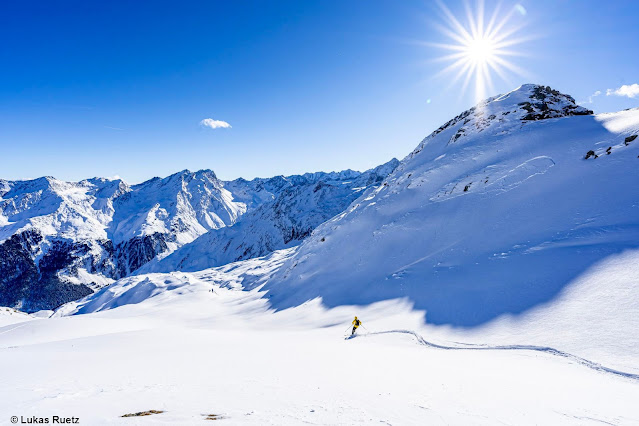
Non-steep meadows are a perfect way to enjoy nature at the moment.
|
Not much snow, yet still a “tense” danger level 3.
We are frequently confronted with the opinion that if the snowpack is shallow, avalanche danger can’t be very high. Currently, just the opposite is the case: the weak layer inside the snowpack can be triggered with particular ease since the snowpack itself is so thin. Only when the weak layer has at least 75 cm of snow on top of it will the weight of a skier have little or no impact in triggering it. Currently, the weak layer fits like a glove onto the triggering of a slab: a weak layer which is very pronounced and in places area-wide; and an equally definitive slab, not very deep, covering a large area.
 |
| Even when blades of grass poke out of the snowpack, the situation can be sizzlingly perilous. Fracture of a naturally triggered slab avalanche in the Arlberg region. (photo: 01.12.2021) |
