Friday 27 March 2020

Favourable avalanche situation continues

A favourable avalanche situation widespread

The danger-level map of the EUREGIO Avalanche Bulletin for Friday 27.03 shows generally low avalanche danger. The situation was similar to that of last week, and it will remain that way over coming days according to weather forecasts of ZAMG Weather Service. As a result of some fresh snow starting in the evening of Saturday 28.03, fresh small snowdrifts at high altitudes and isolated glide-snow avalanches will be the major dangers.

Bildunterschrift hinzufügen

Review of the last week

The information we have received from outlying terrain continues to be quite limited due to the edict of the governor of Tirol (Verordnung des Landeshauptmannes vom 20. März 2020 nach § 2 Z 2 des COVID-19-Maßnahmengesetzes ). Our evaluation of the situation is based primarily on knowledge we gained of snowpack layering before the curfew came into effect; on data coming in from our weather stations; on reports from various valleys; on simulations generated by avalanche models; and from our own empirical analysis linked to current weather conditions.

Cold and windy, very little precipitation

This verbal snapshot was last week’s weather in a nutshell. Before temperatures started to rise steadily starting on Saturday 21.03, some of Tirol’s first (and fairly impressive) thunderstorms of the year could be witnessed on the evening of 20 March.

Convective cloud build-up especially in northern regions led to frequently violent thunderstorms with short bouts of torrential downpour accompanied by thunder and lightning.

At the time, on 20-21 March, huge amounts of precipitation were registered. Subsequently (on Sunday 22.03 and in the furthermost southern regions on 26.03) there was very little precipitation.

The fluctuations visible in the upper graph show last week’s precipitation. The lower graph shows air temperatures and thawing points. The disparity between air temperature (red) and thawing point (blue) is an indicator of cloud cover vs. sunshine. (If both curves run parallel, there is cloud; if not, the sun is shining.)

Eselrücken weather station just north of the Prägraten station portrayed above. Increase in snow at high altitude is visible. Also highly indicative: strength of winds; and the dryness of the air which on 23.03 moved over the land.

The situation in North Tirol closely resembles that of East Tirol. Highly unusual: the thawing point lies at -60°C - in indicator of extremely dry air.

Up to 10 cm of fresh snow in East Tirol on 26.03. seen in the example above at Lucknerhaus.

Extremely dry air masses in some places

The dry air referred to is a major factor during the run-up to spring as regards danger assessment. The snowpack on 23.03 remained firm all day long, despite intensive solar radiation, and developed corn snow if at all, then only slightly on extremely steep south-facing slopes. The snow didn’t melt, but rather sublimated, that is, slipped into a transitional phase from solid to gaseous form. During this situation the snowpack has immense amounts of energy drawn from it, which in turn slows down or halts the melting process. Add the low temperatures to that, and the melting process was brought more or less to a standstill.

During cold days and star-studded nights, water froze and often didn’t thaw during the daytime. Ötztal. (photo: 25.03.2020)

“Penitent snow”
Aside from the positive effect which the dry air had by slowing down the wetness of the snowpack, there was also another interesting phenomenon which could be observed. Through the sublimation process, an unusual snow formation is generated with points rising from the surface, fondly known as “penitent snow” in folk culture. This form is frequently found over widespread areas in the Andes in South America.

Penitent snow in St. Sigmund in Sellraintal (photo: 24.03.2020)

Close-up of the penitent snow (photo: 24.03.2020)

Small snowdrifts at high altitudes

There were very few avalanche prone locations in the mountains last week. At high altitudes and in high alpine regions some snowdrifts were generated which, in the context of the overall situation, had no significance.

An aerial view reveals the snowdrifts generated in the respective aspects. View from Adlersruhe towards Grossglockner. (photo: 22.03.2020)

Isolated glide-snow avalanches

Of note is a minor, highly isolated danger from potential glide-snow avalanches.

Glide-snow avalanche in the Gurgl Group. At upper left, a glide crack and the upturned snowpack are visible, i.e. a further glide-snow avalanche announcing itself. (photo: 22.03.2020) 

Outlook

As outlined above, conditions will be similar to last week’s. Potential minor problem zones stem from fresh snowdrifts at high altitudes and isolated glide-snow avalanches. In isolated cases the latter could be important to highly exposed sectors of roads.

Friday 20 March 2020

The blog will continue to be published regularly

...so that residents can better evaluate potential dangers to infrastructure and settlements. Please undertake no mountain or skiing tours! (FAQ Quarantäneverordnung) Every accident unnecessarily robs the time and energy of rescue services and health system.

Springtime conditions go on...for a bit

Last week was marked by classic springtime conditions, including a slight daytime avalanche danger cycle. In the morning mostly low, in the afternoons mostly moderate danger.

Brief cloudy phases only on 13.03 and 14.03, regionally on 18.03 during the night. Otherwise brilliant sunshine and very dry air masses. Also highly indicative: daily cycle of snowpack surface temperatures.

Conditions improve on Friday afternoon, 13.03. Northern Stubai Alps

Star-studded nighttime skies and dry air stabilize the snowpack which softened superficially the day before

 Avalanche activity is limited. The main danger stems from isolated glide-snow avalanches on steep grass-covered slopes.

Glide-snow avalanches caught by foto-webcam.eu

Glide-snow avalanche and glide cracks in northern Stubai Alps (photo: 15.03.2020)

Caution: cornices continue to break...

...such as here in Boden, Ausserfern (photo: 18.03.2020)

Decisive: continuing moistness/wetness of the snowpack

The assessment of avalanche dangers is currently based on only a few snow profiles. What matters most: snow temperature.

Isotherm snowpack, SE aspect at 2020 m, 26°, on 14.03.2020, northern Stubai Alps

Temperature reserves, NE aspect at 2540 m, 36°, Gurgl Group on 15.03.2020 

Also currently indicative: frequent sequences of melt-freeze crusts on sunny slopes. Inside the snowpack, frozen meltwater canals are often evident.

Parallel to this, a simulation program called SNOWPACK also provides deeper understanding. With it we can better evaluate the extent of snowpack moistness/wetness and loss of snowpack firmness.

This graph shows the simulated water seepage into a fictitious 38° south-facing slopes near the Nachtweide weather station in the Ischgl ski area during the current season. Through a combination of parameters provided by the weather station and the SNOWPACK simulator, it is possible to calculate how much water seeps how deep into the snowpack. Initial wetness is often dependent on heightened wet-snow and glide-snow avalanches. However, below 2200 m and on sunny slopes below 2800 m, the snowpack has been subjected to rainfall and warmth rather frequently this season, thus, the deeper water seepage of the last few days has very little influence on the wet snowpack stability. On shady slopes and at higher altitudes it is a different matter. There, we expect the first simulation of deeply embedded, faceted layers to lead to heightened activity of wet slab avalanches. But that will still take awhile.

This running graph shows the stability of the wet snowpack, calculated with the SNOWPACK simulator. Red signatures denote an unstable, wet snowpack. Blue signatures show how deep the snowpack freezes overnight, giving an indication of how thick the melt-freeze crust is.

The quintessence: a marked wet-snow avalanche cycle is not currently expected, particularly due to the repeated times throughout the winter when the snowpack became thoroughly wet. 

As of 21 March, a cold front: temperatures will drop, temporarily end springtime conditions


On Saturday (21.03) a weak cold front will bring a small amount of fresh snow. Temperatures will remain down. Wet-snow avalanches are thus unlikely for a time. In accordance with the juncture of the season, caution will then be necessary towards diffuse light conditions and loose-snow avalanches. In addition, isolated glide-snow avalanches continue to be possible.

Thursday 12 March 2020

Springtime conditions on the increase

After brief delicate situation for winter sports enthusiasts, quite favourable conditions

Last week was marked by superb powder and favourable conditions as well as a delicate avalanche situation for winter sports enthusiasts. This was on Tuesday, 10-11.03 when a warm front passed over Tirol and numerous naturally triggered avalanches released. These were also observed on 11.03 in the morning hours when diffuse radiation impact weakened the snowpack. The following dry air masses and star-studded skies on Wednesday night (11-12.03) improved the situation, and Thursday was hit by classic springtime conditions with a daytime danger cycle.

Striking: sunny 08.03; warm front on 10.03, initial rise of snow depths, then massive settling due to rain and sun; wet snowpack with outgoing radiation on 11-12.03; a melt-freeze crust forms which can carry loads in places. Snowpack softens as a result.
Then until 14.03 follow two weak cold fronts. Avalanche science points to potential glide-snow avalanches on steep grass-covered slopes and loose-snow avalanches. In very isolated cases there are recently formed snowdrift masses which can be triggered, particularly on shady slopes above about 2800 m. In addition, the fronts referred to also form small, fresh snowdrift masses. Caution is required most at high altitudes in ridgeline terrain in the western regions of North Tirol, i.e. where precipitation was heaviest.

Impressions from this last week

A dream day, full of backcountry skiers throughout Tirol: 08.03.2020. Defereggental. 

Powder in East and North Tirol. Here, descent from Kleinen Kaserer in the Tux Alps. (photo: 08.03.2020)

Very steep terrain was also used and skied. Rosskogel, Stubai Alps. (photo: 08.03.2020)

Finest very light fresh snow in the Tux Alps. An interesting thing was observed: the skins curled up while the snowpack was still dry. That happens only when the snow is extremely loose, the air very dry and radiation already quite intensive. As a result, due to very high temperature disparities, a weak layer was able to form in the uppermost layers of the snowpack (“radiation recrystallisation”). The prerequisite for this was lacking, due to the ongoing weather development.

Avalanche releases were few, in view of the many winter sports enthusiasts who were in outlying terrain. Avalanches were generally small-sized. There was also the risk of being swept along. This happened to one climber in the Wilder Kaiser, who was injured.

Avalanche release Mädelegabel in Ausserfern. (Surface hoar seen here as weak layer, for a short time). (photo: 08.03.2020)

Avalanche release Goinger Törl (photo 08.03.2020). Somewhat unclear is the weak layer, possibly a local, briefly relevant dp.4 (cold on warm) adjacent to a ridgeline, shady slope.

Near the upper avalanche. Shallow slab near a ridgeline on Kleinen Törl. (photo: 08.03.2020)

Warm front on 10-11.03

Please refer to the Blog on 10.03.
The warm fron led to a marked rise in avalanche danger and to high naturally triggered avalanches because the front initially still bore snowfall which transformed to rainfall up to about 2400 m. Thus, a perfect weak layer in the form of cold powder and decomposed crystals existed. The slab formed through the warmth and also through the wind at high altitudes.

Precipitation on 09.03, then a warm front on 10.03, snow changing to rain

Rainfall levels in Tirol at the end of the warm front

In steep terrain, shallow fractures could be provoked rather rapidly during the precipitation. This proves the high proneness to triggering. (photo: 10.03.2020)

In western regions the precipitation was more intensive than expected. The avalanche bulletin was updated for that reason and for 11.03 high danger published for a brief time. High danger (“Ski Tour High”) was also justified for the neighbouring regions in retrospect, where there was more snowfall. Further to the east where there was less precipitation the avalanches were correspondingly smaller. In general, these were superficial slab avalanches and loose-snow avalanches as forecast.

Avalanche releases in the Silvretta. (photo: 11.03.2020)

...some of which reached ascent paths to refuges. (photo: 11.03.2020)

Avalanche releases in Sellraintal. (photo: 11.03.2020)

Avalanche deposit in Zillertal. (photo: 11.03.2020)

Small loose-snow avalanche in Tux Alps. (photo: 11.03.2020)

Successful artificial triggerings. Ötztal. (photo: 11.03.2020)

Artificially triggered avalanche in Pitztal. (photo: 11.03.2020)
Central East Tirol and southern East Tirol were hardly touched by the warm front.

A freerider was lucky in the Wasserkar (Ötztal): swept along by a slab avalanches and buried. After 10 minutes he was dug out of the snow masses uninjured . (photo: 11.03.2020)

Rapid stabilisation as a result of improved weather

When loose powder forms a weak layer, it provides a great advantage over persistent weak layers, since the powder swiftly bonds with the snowdrifts deposited on top of it. This is even more the case when solar radiation is intense and/or temperatures are high. Currently, both are the case. For that reason, the snowpack has stabilised very quickly. Avalanche danger receded swiftly, but rose again in the daytime today on 12.03 due to solar radiation and relatively high temperatures. Water which seeped into the snowpack weakened it superficially.

Impressive shot of water collection zones via photo-working by Lukas Ruetz. (photo: 11.03.2020)

A typical profile in sunny steep terrain currently. Sequence of crusts. Isotherm snowpack. No fracture propagation.

Spring is coming - heed daytime avalanche danger cycle

According to ZAMG Weather Service, following the short weak cold front, a persistent warm period of fine weather will follow as of Sunday 15.03. For winter sports enthusiasts that means: whoever starts out early is doubly rewarded. Avalanche danger conditions are more favourable than later in the day. And with good route planning there is wonderful firn snow to be enjoyed.

Avalanche dangers are expected to be quite recognizable. Attentiveness is required towards the quite large cornices at high altitudes.


Tuesday 10 March 2020

Brief delicate situation in backcountry. Be careful of naturally-triggered avalanches!

The warm front forecast by ZAMG Weather Service arrived today, 10 March, and brought widespread snowfall to Tirol, rainfall at low and intermediate altitudes.

24 hrs of precipitation (as of 10.03, 19:00) which, according to ZAMG Weather Service will terminate at about midnight.

Snowfall at high altitude, increasing rainfall at low and intermediate altitudes due to rising temperatures. Strong-to-stormy winds at high altitudes. Hot spot: esp. western and northern regions of North Tirol.

This has increased avalanche danger significantly as a result, to considerable in the regions where snowfall was heaviest. We observe already this evening at high altitudes increasingly frequent naturally triggered avalanche activity. Avalanches (mostly small-sized) can be triggered by minimum additional loading. A very loose layer of fresh snow can serve as a weak layer. The slab which is necessary for slab avalanches is forming on the surface due to rising temperatures, and tomorrow due to increased solar radiation.

First small avalanches during heavy snowfall and rising temperatures. Silvretta. (photo: 10.03.2020)

Winter sports enthusiasts triggered this slab today (10.03) with a fracture depth of 10 cm. Such a minor fracture depth indicates a very reactive weak layer (loose powder and decomposed snow). Silvretta. (photo: 10.03.2020)

Tomorrow (11.03) we can expect more frequent superficial slab avalanches as a result of the solar radiation, especially on sunny slopes where residual cloud persists, but also on shady slopes due to diffuse radiation. This will occur increasingly in regions where precipitation was heaviest. In addition, numerous loose-snow avalanches can be expected in extremely steep terrain and isolated glide-snow avalanches on grassy slopes.

In short: whoever is in outlying terrain tomorrow needs very good knowledge of the terrain and an ability to assess the risks on-site.

In the regions where precipiation was less, the situation is better. But there, a daytime rise in avalanche danger requires caution due to higher daytime temperatures.

Thursday 5 March 2020

Mostly favorable conditions. Be careful of fresh high-altitude drifts and loose-snow avalanches.

Predominantly favorable conditions

Avalanche danger in Tirol is moderate above 2200 m, elsewhere danger is low. Highest caution is necessary towards fresh snowdrift masses, especially trigger-sensitive on very steep shady and ridgeline slopes at high altitudes. In addition, the fresh snow reacts very swiftly to solar radiation and diffuse light in this season, meaning that increasingly frequent loose-snow avalanches can be expected on extremely steep slopes.

With good planning it was possible to enjoy powder last week. Avalanche prone locations were not large and easily recognized. (photo: 28.02.2020)

Danger level map for 06.03.2020


Weather review

Variable conditions
This last week was highly variable: warm and cold fronts brought continual precipitation (snowfall above 1000 m). In between there was sunshine. Strong to stormy winds were always present.

Once again: variable weather, e.g. at Axamer Lizum. Particularly striking: brief high windspeeds on 27.02 and 28.02. 

Wind impact and snow transport on Hintertux Glacier (photo: 29.02.2020)

Weather review in detail (by Marco Knoflach)

Last Saturday (29.02.2020) the second warmest February in history came to an end with a westerly foehn air current, bringing mild air masses our way before on Saturday night (01.03.2020) a cold front made temperatures drop. The widespread low over northern and central Europe brought quite wet and late-wintery cold air masses to the Alps. Following a brief intermediate high on Wednesday (04.03.2020) the next perturbance will pass through today (05.03.2020).


Snowpack

Overall snow depths at high altitudes correspond to average depths for this juncture of the season.

Snow depths are below average at low and intermediate altitudes, average at higher altitudes.

Snow depths in Kühtai. The dark line shows the current depth, near to the average level.

Typical snow distribution in Tirol. View from Mieming mountains towards northern Stubai Alps. (photo: 01.03.2020)
Fresh snow was distributed in repeated bouts during the week.

The fresh snow was a positive contribution, most of which was deposited in East Tirol


Weather station Thurntaler near Sillian in southern East Tirol. Easily recognized: increased fresh snow on 01-03.03.

Innergeschlöss (photo: 03.03.2020)

Problem zones are most likely inside the fresh snow near the surface.

The snow profiles obtained over the last week in Tirol were generally stable. Only surface-near layers were triggerable for a short time.

Glide cracks when treading the snowpack and superficial drifts gliding away. Schober Group. (photo: 04.03.2020)

Massive graupel layers were conspicuous.

Grains of graupel inside the fresh snow. Potential weak layer only where they were several centimetres thick. East Tirolean Main Alpine Ridge. (Graupel was also observed in the Tux Alps.) (photo: 04.03.2020)

Indicative for the current situation: no fractures during stability tests. Graupel layers near the surface.

Snowpack is moist up to intermediate altitudes, yet stable. Jöchelspitze, Ausserfern (photo: 01.03.2020)

Twigs and pine cones inside the snowpack demonstrate massive wind impact. Tux Alps. (photo: 03.03.2020)

Activating persistent weak layers (old snow problem) is known and not known. Conceivable on shady very steep slopes near the treeline in southern East Tirol.

Naturally triggered avalanche in Obertilliach. The avalanche appears to be a near-surface snowdrift problem. In very isolated cases, this region has fractures of expansively metamorphosed (faceted) layers which recently formed below the melt-freeze crust in places where snow was shallow. Avalanche releases were small-to-medium. (photo: 05.03.2020)

Change from dry to moist snowpack surface

Appropriate to this juncture of the season, the snowpack surface currently becomes moist quite rapidly from diffuse solar radiation.

Recognizable in the rocks: the flowing melt-water. Mieming Massif. (photo: 01.03.2020)

Reserved for the fittest backcountry skiers: accumulating moistened surface snow, beneath that dry snow. Tannheimer Tal. (photo: 01.03.2020)

En route in outlying terrain on the way to Pforzheimer Refuge. The sun, which is visible, is causing striking warmth inside the snowpack which enhances the stabilization of freshly-generated snowdrift masses. (photo: 05.03.2020)


Avalanches during the last week

Only a few avalanches involving persons occurred to our knowledge during the last week. With all avalanches, fresh snowdrifts were released on very steep to extremely steep slopes.

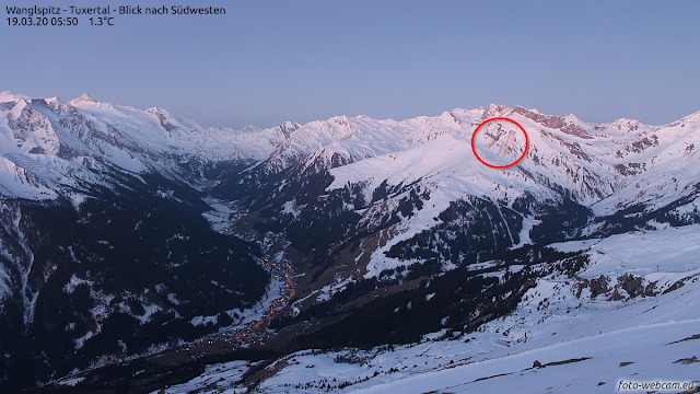
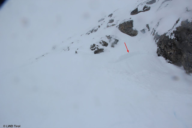
Avalanche Wanglspitze. Two persons were able to escape the avalanche near the upper fracture zone of the release. (photo: 28.02.2020)

Close-up of the photo above. Wanglspitze  (photo: 28.02.2020)

Avalanche Hinteres Rendl (photo: 28.02.2020)

A quite typical slide. Stubai Glacier (photo: 01.03.2020)
Artificial triggerings with explosives were generally without much success last week.

Visible is the crater caused by the explosion. Minor-to-medium success. (photo: 01.03.2020)

What’s next?

The weather will remain variable in coming days. Stable conditions are not in view, according to ZAMG Weather Service. Seen from today’s perspective, Sunday will be dry (08.03.2020).

During the next few days, powder snow can always be enjoyed, like here on the Main Tauern Ridge on 01.03.2020.

The main danger will continue to stem from fresh snowdrifts at high altitudes, and in particular on very steep ridgeline slopes. Also, as was the case in the last few days, we have to expect loose-snow avalanches.

Loose-snow avalanches following snowfall. Northern Massif. (photo: 28.02.2020)
Needs to be critically assessed: ridgeline terrain during and immediately after snowfall-plus-wind.