Friday 28 January 2022

Variable weather is changing the avalanche situation

Some fresh snow and storm winds are ratcheting up avalanche danger

After several days of mostly favorable avalanche conditions and low danger levels, the danger will increase somewhat over the next few days.


Gefahrenstufenkarte für heute, 27.01.2022. In weiten Teilen der Alpen überwiegt geringe Lawinengefahr. Ab morgen, 28.01. steigt die Gefahr langsam, aber stetig an.
Danger Level map for today 27.01.2022. In far-ranging areas of the Alps, low danger predominates. Starting tomorrow, 28.01, danger will rise slowly, but continually.


Main danger: fresh snowdrifts increasingly numerous on shady slopes and ridgelines

By the weekend, snowfall and storm-strength winds from the northwest will generate new snowdrift accumulations. They will occur mostly in the NE regions where snowfall is heaviest, where between 5 and 15 cm of fresh snow is anticipated tomorrow.


48h Neuschneeprognose bis Samstag, 29.01.2022 Früh
48-hr new snow forecast until Saturday, 29.01.2022 early morning


Bei der Station Nachtweide in der Silvretta Skiarena erkennt man bereits den inzwischen starken bis stürmischen Wind in der Höhe.
At Nachtweide station in Silvretta Skiarena, strong-to-storm strength high-altitude winds already visible.


Particularly on steep shady slopes we expect heightened proneness to triggering in these freshly generated snowdrift masses. This is mostly due to the structure of the uppermost layer of the snowpack: it consists predominantly of loose, expansively metamorphosed (faceted) snow, in some places of (encrusted) surface hoar. (For details, see below...) Heightened caution is also urged in ridgeline terrain and behind protruberances in the other aspects. Poor visibility can make evaluating the risks on-site more difficult.


Review of last week

After the last Blog, when we warned about accident-prone days there actually were increasingly numerous reports of avalanches involving persons. These were mostly small-to-medium slab releases, logically enough more in the eastern regions where snowfall was heaviest. There were no injuries. What was also pleasing was that the avalanches were so frequently reported to the Avalanche Headquarters in Tirol so that no unnecessary rescue operations were sent out.

Some avalanches involving persons

For details about all the known avalanches, click here:

Lawinenabgang Filzenkogel in den Nördlichen Zillertaler Alpen. Oben erkennt man die Einfahrtsspur. Der Pfeil zeigt die Ausfahrtsspur, der Kreis die Person, die aus der Lawine ausfahren konnte (Foto: 23.01.2022)
Avalanche Filzenkogel in northern Zillertal Alps. Visible above: the entry track. The arrow points to the exit track; encircled is the person who was able to ski out of the avalanche path. (photo: 23.01.2022)


Schneebrettlawine Sonntagsköpfl in den Tuxer Alpen (Foto: 23.01.2022)
Slab avalanche Sonntagsköpfl in the Tux Alps (photo: 23.01.2022)


Kleines Schneebrett in den Tuxer Alpen (Foto: 23.01.2022)
Small slab in the Tux Alps (photo: 23.01.2022)


Schneebrettabgang Hüttenkogel im Zillertal. Bei einem ähnlichen Abgang wurden Personen im Nahbereich im Staubereich der Stahlschneebrücke verschüttet, blieben jedoch unverletzt. (Foto: 23.01.2022)
Slab release Hüttenkogel in Zillertal. In a similar incident, persons near the deposit zone of the steel snow bridge were buried, but escaped unhurt. (photo: 23.01.2022)

In eastern regions, lots of fresh snow, then beautiful weather took over, avalanche danger quickly receded.

Hot spots during last week’s snowfall (21-23.01): parts of the Karwendel; Wilder Kaiser / Waidring Alps region; eastern Kitzbühel Alps.


Anfangs Neuschnee und Wind, dann zunehmend Schönwetter bei warmen Temperaturen. Mitunter windig.

 Fresh snow and wind to start with, then increasingly beautiful weather, warm temperatures, often windy.

 
Unverkennbar sowohl im Vordergrund, als auch im Hintergrund: Windeinfluss auf den Bergen. Osttiroler Tauern (Foto: 23.01.2022)
Unmistakeable in foreground and in background: wind impact. East Tirolean Tauern (photo: 23.01.2022)

Fog reinforced (encrusted) surface hoar

An interesting phenomenon was observed towards the end of the round of precipitation starting Saturday, 22.01 in the evening: near fogbanks and receding swathes of fog, surface hoar formed over widespread areas. Intensely cooled waterdrops also froze on the snowpack surface so that subsequently the surface hoar became encrusted, in some places ice sheets even formed. The fine weather which followed, including perfect solar radiation, then reinforced the expansive metamorphosis beneath these crusts. This is an important factor in the approaching snowfall, since there will be poor bonding to the new snow/drifts.


Nebelbänke im Außerfern (Foto: 23.01.2022)
Fogbanks in Ausserfern (photo: 23.01.2022)


Im Hintergrund erkennt man abziehenden Nebel, im Vordergrund den aufgrund des Nebels gebildeten Oberflächenreifs. Nördliche Stubaier Alpen (Foto: 23.01.2022)
In background, receding fog. In foreground, the surface hoar it created. Northern Stubai Alps
(photo: 23.01.2022)


Oberflächenreif im Bereich der Ahornspitze in den Zillertaler Alpen (Foto: 26.01.2022)
Surface hoar near Ahornspitze, Zillertal Alps (photo: 26.01.2022)


Thanks to our numerous observers, their explorations of the terrain and reports made by winter sports enthusiasts, we have an excellent overview of how far-reaching this phenomenon really is. Typical is the band of altitude inside which (encrusted) surface hoar was so prevalent. The crusts varied greatly, were thicker in the north than in the south of North Tirol. It was almost exclusively hoar only on the surface.

Verkrusteter Oberflächenreif im Tannheimertal (Foto: 23.01.2022)
Encrusted surface hoar in Tannheimertal (photo: 23.01.2022)


Grobe Verbreitung des "verkrusteten" Oberflächenreifs. Man findet diesen vornehmlich im Nordsektor!
Rough spread of (encrusted) surface hoar: all in northern aspects.

Below-average snow depths

Nothing has changed yet in the starkly below-average snow depths for this juncture of the season.


Aktuelle Gesamtschneehöhe (magenta) bei der Station Steeg im Außerfern. Die dunkle Linie zeigt im Vergleich dazu das langjährige Mittel an. Zudem werden bisherige Maxima und Minima dargestellt.
Current overall snow depths (magenta) at Steeg station in Ausserfern. The dark line shows the long-term medium values. In addition, maxima and minima are also depicted.


Im Navistal: Sonnseitig erinnert die Ausaperung bereits an das Frühjahr (Foto: 26.01.2022)
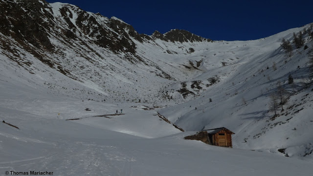
In Navistal: on sunny slopes, the bare ground looks like spring. (photo: 26.01.2022)

 
Blick vom Ausgang des Ötztals in Richtung Norden. (Foto: 25.01.2022)
View from Ötztal exit to the north. (photo: 25.01.2022)


Outlook

The variable weather conditions which are being launched are expected to become more turbulent as of Sunday, 30.01: storm-strength winds, then a sequence of cold and warm fronts, will mark a re-entry of real winter, including measurably higher avalanche danger. The focus of precipitation: western and northwestern regions, according to ZAMG Weather Service.


Die Grafik zeigt die modellierte, aufsummierte Neuschneesumme mit entsprechenden Abweichungen. Zwischen Montag, 31.01. und Mittwoch, 02.02. soll es winterlich werden. (Region Westliche Lechtaler Alpen)
The graph shows a computer model of summed-up amounts of fresh snow with appropriate leeway. Between Monday 31.01 and Wednesday 02.02, winter will return (region: western Lechtal Alps)


Windprognose für Sonntag, 30.01.2022
Wind forecast for Sunday, 30.01:  storm!


What is important for us avalanche forecasters before such rounds of snowfall get underway is the most precise possible analysis of the current snowpack layering. What makes that problematic currently: surface layers, e.g. the encrusted surface hoar layers and faceted crystals beneath them which we described above. Or else snowpack surfaces far removed from wind impact which are expansively metamorphosed (of deformed and faceted crystals) or else “burled powder.”


Recht typisches Schneeprofil in flachem Gelände bzw. in schattigen Lagen. Lockerer Schnee an der Schneeoberfläche. Eingelagerte Regenkrusten, u.a. von der Warmfront vom 29.12. auf den 30.12.2021. Meist nur unvollständige Brüche zwischen den Krusten. Axamer Lizum (Foto: 24.01.2022)
A highly typical snow profile in flat terrain / on shady slopes. Loose snow on surface, embedded rain crusts, from a warm front on 29-30.12.2021 - mostly partial fractures between the crusts. Axamer Lizum (photo: 24.01.2022)


"Noppenpulver" im Jamtal (Foto: 25.01.2022)
“Burled powder” in Jamtal (photo: 25.01.2022)


Due to increasingly stormy conditions in the mountains, the snowpack surface can become irregular and more varied, which is actually an advantage. Large-area avalanche releases would become less likely. It is also calming that the old snowpack is so stable. This is especially the case on steep sunny slopes, but is also found on shady slopes (where potential weak layers snow no tendenc towards fracture propagation). Also, near the embedded melt-freeze crusts there were no malignant developments evident, e.g. dp-4 (cold on warm) observed.

For further details on ongoing developments and latest forecasts, a special blog will be published at latest on Monday, 31.01.2022.

Saturday 22 January 2022

Caution: accident-prone days in eastern regions where snowfall was heaviest! Restraint is called for.

The most important message, right off the bat: 


In the regions where snowfall has been heaviest, you need profound knowledge of the terrain and of avalanche science, you also have to be calm and restrained when you are in backcountry. Danger zones are widespread, often difficult to recognize, making accidents quite likely. By the way, we are very close to Danger Level 4 (HIGH danger) in the areas where snowfall has been heaviest.


Warm front raises proneness to triggering

Today, 22.01.2022, the warm front forecast by ZAMG Weather Service moved into the eastern regions, bringing 20-50 cm of fresh snow (by tomorrow morning). Thus, within 48 hours there has been up to 100 cm of fresh snow registered locally, accompanied by strong and gusty northerly winds. Since the perturbance has the character of a warm front, we have to assume that initially cold new snow will be covered over by warmer, wind-impacted snow. The colder new snow can constitute a widespread trigger-sensitve weak layer for the bonded new snow which is deposited on top of it. In addition, there is greater potential of slab avalanches due to the expansively metamorphosed surface on shady slopes which were previously protected from wind (referred to in the last blog). 


Einer der "hotspots" des bisherigen Niederschlagsgeschehens: Die Seegrube oberhalb von Innsbruck. Seit 20.01. abends bereits gut 50cm Schneehöhenzuwachs. Über Nacht sollen es nochmals bis etwa 50cm werden. Starker Wind. Temperaturanstieg!
One of the hotspots of this round of precipitation: Seegrube above Innsbruck. Since 20 January: about 50 cm of fresh snow. Overnight, another 50 cm could be added to it. Strong winds. Rising temperatures.


24-Stunden Neuschneeprognose 22.01. auf 23.01.2022. Lokal ist laut letzten Prognosen auch mehr Schnee zu erwarten.
 24-hr fresh snow forecast for 23 January 2022. Latest forecasts predict even more new snow.


Windig ist es und war es auf den Bergen. Am Weg zum Grubenkopf - Zentrale Stubaier Alpen. (Foto: 21.01.2022)
Windy, past and still ongoing. En route to the Grubenkopf - central Stubai Alps. (photo: 21.01.2022)


Naturally triggered avalanches

In regular increments, naturally triggered avalanches can be expected. These will be slab, glide-snow and loose-snow avalanches.
 

Slab avalanches

Particularly in the regions where fresh snowfall has been heaviest, naturally triggered avalanches can be increasingly expected during the evening and nighttime hours. These will be mostly medium-sized, in isolated cases large-sized. Since clouds will disperse tomorrow in the regions where snowfall was heaviest, there is no longer an impulse for further naturally triggered avalanches from solar radiation.

Glide-snow avalanches

At low and intermediate altitudes the fresh fallen snow was frequently deposited on bare ground, at least on sunny slopes. During the coming days, once again in the regions where snowfall has been heaviest, increasingly frequent glide-snow slides and generally medium-sized glide-snow avalanches can be expected there. The beautiful weather which is forecast with slowly rising temperatures will slightly raise the likelihood of such avalanches triggering.

Loose-snow avalanches

Tomorrow, Sunday 23.01, wherever it has snowed in the last few days and sunshine has been strong, naturally triggered loose-snow avalanches can be expected. Elsewhere this will be the case on Monday, 24.01 at latest. This means loose-snow avalanches in extremely steep, mostly rocky terrain on south-facing slopes.


Today (22.01): first avalanches involving persons

Tirol Headquarters reported today two “negative avalanches” - in other words, releases which involved persons, although they were not injured. This occurred in the Sonntagköpfl zone in the eastern Tux Alps and in the zone of Mitterkars in the town of Brandberg in the northern Zillertal Alps.


Accident-prone days – we urge you to calm restraint in your undertakings!

Following a stormy period of snowfall where improving weather conditions usually bring more frequent avalanches involving persons, we would like to point out the above avalanches as a warning. 

Thursday 20 January 2022

Fresh snow + wind: dangerous snowdrift accumulations being generated regionally. More and more avalanche prone locations on shady slopes and in ridgeline terrain.

 Fresh snowdrift accumulations: assess them critically!


Following a long phase of favorable avalanche conditions, the overall situation is undergoing a change, particularly in the regions where snowfall is heaviest. In the northern and especially in the eastern regions of North Tirol, 30-50 cm of fresh snow is expected by Sunday, 23.01.2022, even more from place to place, the bulk of which is anticipated in the Waidring and eastern Kitzbühel Alps.

72h Neuschneeprognose.: Schwerpunkt der Niederschläge im (Nord-)Osten des Landes
72-hr forecast for new snow: focus of the precipitation in (north)east


Accompanying the snowfall will be strong-to-storm strength winds. Thereby, wide-ranging snowdrift accumulations will be generated, at very least above the treeline. These drifts will be most easily triggered in wind-protected zones on shady slopes. There the old snowpack surface consists predominantly of loose crystals which will constitute a dangerous weak layer for drifts deposited on top of them. Slabs can then be triggered with ease by no more than the weight of one single skier or boarder. In the regions where snowfall is heaviest, even naturally triggered avalanches can be expected. Caution is also urged in ridgeline terrain in all aspects and on steep slopes behind protruberances in the landscape.


Increasingly frequent danger zones on shady slopes

Unterwegs in den Östlichen Kitzbüheler Alpen. Schattig besteht die Schneeoberfläche in windberuhigten Bereichen aus lockeren kantigen und filzigen Kristallen. Diese lagern auf der Regenkruste von Ende Dezember. Auch die Basis der Schneedecke ist häufig locker. (Foto: 14.01.2022)
En route in the eastern Kitzbühel Alps. On shady slopes the snowpack surface in wind-protected zones consists of loose, faceted and decomposed crystals which lie deposited atop a rain crust which formed at the end of December. Also the snow base is expansively metamorphosed, i.e. full of faceted crystals. (photo: 14.01.2022)


Ein sehr ähnliches Bild in der Silvretta. Schattig ist die Schneeoberfläche in windberuhigten Bereichen locker - die entscheidende Schwachschicht für darüber gelagerte Triebschneepakete. (Foto: 19.02.2022)
A similar picture in the Silvretta. On shady slopes the snowpack surface in wind-protected zones is loose. That is the decisive weak layer for freshly generated snowdrift masses. (photo: 19.02.2022) 


Mitunter hat sich im Schatten auch noch Oberflächenreif halten können. Dort wo dies der Fall ist, muss man von einer hohen Störanfälligkeit des darüber gelagerten Neu- bzw. Triebschnees ausgehen. Gebietsweise kann dies auch für schattige Waldlichtungen zutreffen. Foto aufgenommen am 15.01.2022 auf 1100m im Mieminger Gebirge.
In many places on shady slopes, surface hoar has persisted. Wherever it did, high proneness to triggering can be assumed for fresh snow and snowdrift accumulations which are deposited on it. Regionally this can also be the case in shady forest clearances. Photo taken on 15.01.2022 at 1100m in the Mieming Massif.


Bezeichnend für die vergangene Woche war eine deutliche Temperaturinversion: Im Tal war es kälter als auf den Bergen. Hier am Karnischen Kamm bildete sich große Oberflächenreifkristalle. (Foto: 14.01.2022)
 Indicative of this last week was a massive temperature inversion: in the valleys it was colder than in the mountains. Here on the Carnic Ridge, huge surface hoar crystals formed in the valleys.
(photo: 14.01.2022)


Better point of departure: sunny slopes

Contrarily, on sunny, very steep slopes, the warm temperatures and solar radiation had a big effect on the snowpack.  On the one hand, the snowpack became bare in places; on the other, surface crusts formed to an increasing degree. In addition, the water that had seeped into the snowpack which then froze during the cold, clear nights reinforced the bonding of already existing crusts with each other. The upshot: weak layers in the old snow are now much more seldom. Nonetheless, caution is still urged: during the snowfall, weak layers can form inside the masses of fresh snow (graupel or loose, blanketed over fresh snow) particularly in regions with heavy snowfall.


Fortschreitende Ausaperung im besonnten Gelände. Osttiroler Tauern (Foto. 16.01.2022)
The slopes becoming bare in sunny terrain. East Tirolean Tauern (photo. 16.01.2022)


Aus extrem steilem Gelände lösten sich mancherorts feuchte Lockerschneelawinen (Foto: 15.01.2022)
In extremely steep terrain, moist loose-snow avalanches frequently triggered. (photo: 15.01.2022)


Schneeprofil auf 2685m, SW, 36°. Interessant sind die zwischen und unterhalb von Schmelzkrusten vorhandenen, gefrorenen Wasserkanäle, welche stabilisierend wirken. (Foto: 19.01.2022)
Snow profile at 2685m, SW, 36°. Fascinating: the frozen water canals between and beneath the melt-freeze crusts. They have a stabilizing effect. (photo: 19.01.2022)  


Restraint in outlying terrain where snowfall is heavy

It’s clear as glass: after such a long period without precipitation, powder alarms are ringing. Nevertheless, we appeal to the calm, sane reason of all winter sports enthusiasts to not plunge gleefully and carefree into the powder in backcountry, but to adapt to the conditions. Whoever wants to be out in the regions where snowfall is heavy, absolutely needs to exercise a high degree of restraint.

Thursday 13 January 2022

Predominantly favorable situation

 Main danger remains fresh snowdrifts


Right off the bat: the overall situation is favorable. Caution is urged towards freshly generated snowdrift accumulations. They are likeliest to trigger in very steep terrain, often near ridgelines or behind protruberances. Weak layer: blanketed champagne powder, also faceted crystals over small areas in the vicinity of surface-near melt-freeze  crusts. Most of the time these are small-sized avalanches, thus, the risks of taking a fall outweigh those of being buried in snow.


Small, partly blanketed slab avalanche - Glockturm Massif. photo: (13.01.2022)

Thus, the snowpack is without much tension. Surfaces often show striking effects of wind. The embedded crusts are omnipresent. And just as omnipresent is an expansively metamorphosed (faceted) ground-level snowpack at high and high-alpine altitudes. Snow quality worsened during the week. Powder which is a joy to ski through is becoming a rarity....


Wind was a frequent companion in backcountry last week. Stubai Glacier (photo: 11.01.2022)


Wind impact is amply evident. Deferegger mountains (photo: 08.01.2022)


Wherever the snowpack surface is ‘knobbed’ sking is still a pleasure. Glockturm Massif
(photo: 13.01.2022)


Below average snow depths


A glance at the long-term records of our most ardent observers makes it clear: currently in most parts of the land, snow depths are below average.


Graphs of observer Klaus Friedl from Boden, Lechtal: the upper graph shows measured maximum and minimum snow depths since 1960. In addition, also mean values and, in magenta, current overall snow depths are depicted. These lie below the 61-year mean value. The second graph shows the fresh snow measured until now. The lower graph depicts temperatures, where the maximum temperature at the beginning of January can be seen.


The effects in outlying terrain are visible when you are out in backcountry. Making abrupt (forced) acquaintance with stones occurs far more often.


Backcountry in the northern Stubai Alps (photo: 09.01.2022)


The “sharks” freeriders are so terrified of: just barely covered stones which drastically raise the danger of falls and injuries during descents. (photo: 13.01.2022)


On the lookout for dp.4 (danger pattern: cold on warm)


We are currently following most tenaciously the possible development of faceted crystals near the rain crust which developed during the warm front on 29-30 December. In some snow profiles we have seen signs of this.

We have had only two reports of such an awful development, i.e. a possible fracture propagation. This was at 2700 m in very steep, sunny terrain, but was small. Due to the weather forecast (lots of sunshine, mild temperatures) we assume that dp.4 will strike only very small problem zones on wind-loaded very steep slopes in a limited band of altitude and aspect.


Weather-station graphs from 1 January: above average temperatures initially. The snowpack surface became moist. Then on 5 January, snowfall and plummeting temperatures: ideal conditions for danger pattern 4 to develop. Also visible: lots of wind.


To be prepared for the next round of snowfall (which we will have to wait for) we always follow the developmenet of the snowpack. Currently our focus is on the expansive metamorphosis near crusts. Ausserfern (photo: 11.01.2022)


The arrow points to a layer of faceted crystals above the rain crust from the end of December, generated due to dp.4: western Kitzbühel Alps. 1660m, North, 20°.


In order to make the picture of this development sharper, we are grateful for your observations in outlying terrain. Please send your mails to: lawine@tirol.gv.at or snow profiles and stability tests to www.lawis.at. Thank you!

Wednesday 5 January 2022

Considerable avalanche danger regionally due to fresh snow and wind

 Cold front spikes avalanche danger


Fresh snowdrifts at the main peril

A cold front moved swiftly through Tirol today (05.12.2022), bringing fresh snow everywhere. Mostly it was 10-20 cm, in some places 30 cm. That plus the strong winds at high altitudes generated fresh snowdrift accumulations. These are currently the main danger for winter sports enthusiasts. In the regions where snowfall was heaviest, they are deeper and wider, making them more dangerous. With some experience in assessing avalanche dangers on-site, they can be recognized (as long as visibility permits) and circumvented. Such danger zones occur particularly behind protruberances, in ridgeline terrain, in gullies and bowls.


Bereits gestern am 04.01.2022 legte der Wind in der Höhe zu. Samnaungruppe
Winds intensified yesterday (04.01.2022) at high altitudes. Samnaun Massif


Schneedifferenz seit heute, 05.01. in der Früh
Snow differences since 05.01, early morning


Highly varied snowpack

Viewing the snow distribution and snowpack structure, in particular the surface before the cold front moved in, it is easy to see a highly varied snowpack. This is positive, tells us that there are not great fracture propagations, but rather, local problem zones due to the fresh snowdrifts.


Snow distribution in Villgraten valley (photo: 01.01.2022)


Ein ähnliches Bild in den Nördlichen Stubaier Alpen (Foto: 01.01.2022)
A similar picture in the northern Stubai Alps (photo: 01.01.2022)


Eine von Regenrinnen geprägte Schneeoberfläche in den Allgäuer Alpen (Foto: 01.01.2022)
Snowpack showing pronounced rain gullies. Allgäu Alps (photo: 01.01.2022)


Eine von Wind und Sonne geprägte und dadurch ebenso unregelmäßige Schneeoberfläche in größeren Höhen. Karnischer Kamm (Foto: 04.01.2022)
Snowpack surface showing striking effects of wind and sun, full of variations at high altitude. Carnic Ridge (photo: 04.01.2022)


A view inside the snowpack often shows layers not prone to triggering. Except for a small nest of depth hoar where the snow is shallow in ridgeline tererain. These layers are often blanketed by shallow, hardened, older snowdrift masses and can be triggered particularly in extremely steep terrain.


Typisches Schneeprofil: Brüche in der Schneedecke können sich meist nicht fortpflanzen. Die Altschneedecke ist verbreitet stabil. N, 2600m, 34°, Deferegger Alpen
Typical snow profile: fractures in the snowpack can usually not propagate. The old snowpack is generally stable. N, 2600m, 34°, eastern Deferegger Alps


Weak layers on which the freshly generated snowdrifts could release are thus found inside the fresh fallen snow itself, sometimes in the form of graupel layers or due to soft layers of fresh snow. At high altitudes, most parts of the land thereby have moderate avalanche danger at high altitudes. Thus, the current considerable danger level is closer to the lower zone of that level in areas where recent snowfall has been heavy.


A short review: record temperatures at New Year

Last week was unusual in terms of weather: much too warm. Thus, to name an example, in Galtür or St. Anton am Arlberg temperatures prevailed which were higher than ever before measured.

After the warm front passed through (29-30.12) when the rain frequently extended up to 2600 m, followed by a warm-weather phase until 4 January, the snowpack was, on the one hand wet at low and intermediate altitudes, moist on high altitude sunny slopes, and on the other the weak layers collapsed - but ultimately the snowpack stabilized.


Ein noch nie dagewesenes Bild: Die rote Linie zeichnet Rekordtemperaturen in Galtür auf.
Something never seen before: the red line shows record-breaking temperatures in Galtür. 


Outlook

Initially, the snowdrift problem remains the main danger.