Thursday 31 March 2022

Wintery in the mountains again

One of the driest months of March in history is behind us. And now, winter is coming back.


With the precipitation beginning today, 31.03, the not-quite-driest month of March in measurement history comes to an end. For Innsbruck, however, it was the sunniest March in measurement history. That is now at an end. April with its well known variable character seems to be arriving right on schedule. In Tirol, precipitation will set in everywhere today, initially as rainfall at intermediate altitudes, successively over the next few days as snowfall down to the valley floor. In the mountains, up to 50 cm of fresh snow is anticipated by Sunday, 03.04, more from place to place. The southerly/southwesterly air current will shift to a northerly air current. Winds will tend to be light. Weather conditions remind us of situations which are typical of springtime: due to increasing convective precipitation, highly varied snow depths can be expected, but also quite pronounced increases in fresh snow depths with ascending altitude.


72h-Neuschneesumme bis Sonntag, 02.04.2022
72hr-fresh snow totals until Sunday, 03.04.2022


Ende der Trockenperiode: Am 30.03. setzte im südlichen Osttirol Niederschlag ein. Die Temperatur geht nun deutlich zurück.
End of the dry period: on 30.03 in southern East Tirol, precipitation set in.
Temperatures dropping significantly.


Avalanche danger is increasing (somewhat), after a long phase of favorable conditions

During the month of March, a short interim of favorable condition, frequently with low avalanche danger, prevailed (mid-March had a pronounced springtime avalanche cycle).

Prior to snowfall we always intensely analyse the layering of the old snowpack and the old snowpack surface. Both have immediate impact on future avalanche danger. Currently, the point of departure is good: the old snowpack is stable throughout Tirol, the old snowpack surface is irregularly configured.


Schneedeckenuntersuchung gemeinsam mit Lawinenhundeführer in Kühtai in den Nördlichen Stubaier Alpen. (Foto: 29.03.2022)
Snowpack analysis together with avalanche dogs in Kühtai, northern Stubai Alps.
(photo: 29.03.2022)

 
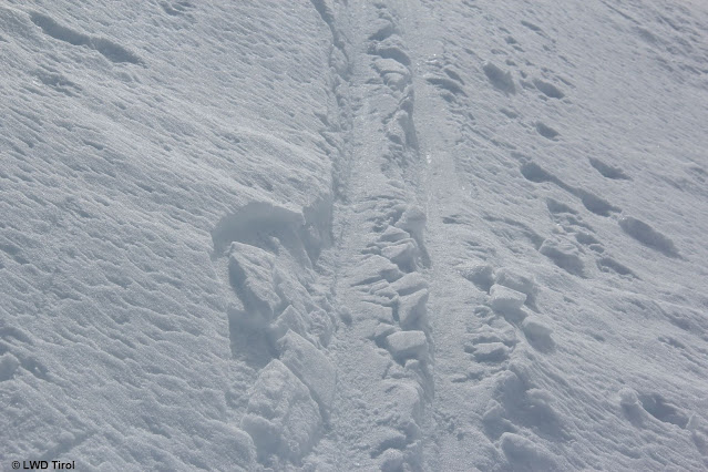
Unregelmäßige Altschneeoberfläche. Silvretta. (Foto: 25.03.2022)
Irregularly configured old snowpack surface. Silvretta. (photo: 25.03.2022)


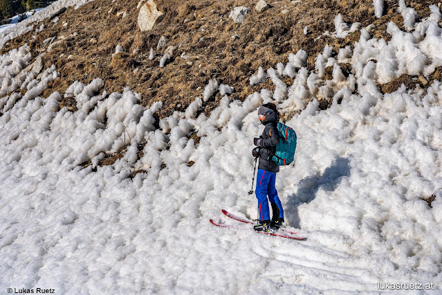
Außergewöhnlich rau und unregelmäßig: Büßerschnee im sehr steilen besonnten Gelände. Liebenerspitze - Ötztaler Alpen. (Foto: 26.03.2022)
Unusually raw and irregular: ragged snow on very steep, sunny slopes. Liebenerspitze, Ötztal Alps. (photo: 26.03.2022)

Due to these conditions as a point of departure, but also due to light winds during the previous rounds of snowfall, avalanche danger will increase only slowly. Problem zones still have to evolve inside the masses of fresh snow. The following scenarios are imaginable:
  • In the zones where fresh snowfall is heaviest and where winds are strong enough for snow transport, fresh snowdrift accumulations will be generated. A weak layer is possible to begin with beneath the snow which fell without much wind impact. Caution urged on very steep, wind-protected, ridgeline slopes.
  • Loose-snow avalanches on extremely steep slopes: these will be observed with increasing frequency whenever the sun comes out in wind-protected zones where snowfall is heavy. This will probably be next Monday, 04.04.
  • Slab avalanches in areas where snowfall is heaviest and winds are light will occur whenever the sun comes out. Due to solar radiation the snowpack will be well consolidated, and thereby, a slab can form. The weak layer is the layer of still loose powder snow beneath it. This will be a short-lived problem which, however, can expand rather quickly, especially amid diffuse light conditions.
  • Glide-snow avalanches: these can release in very isolated cases on steep, smooth slopes near the already existing glide cracks in the snowpack. Also conceivable, in addition, are relatively small glide-snow avalanches on steep grass-covered slopes in the zones where fresh snowfall is heaviest where the slopes were already bare before the precipitation.


Risse in der Schneedecke als Zeichen für eine Gleitbewegung der Schneedecke. Griesner Alm - Wilder Kaiser (Foto: 28.03.2022)
Cracks in the snowpack: bellwethers of gliding movement of the snowpack. Griesner Alm - Wilder Kaiser (photo: 28.03.2022)


Eingekreist: Potentielles Gleitschneeproblem. Gamskopf. Westliche Kitzbüheler Alpen (Foto: 27.03.2022)
Encircled: potential glide-snow problem. Gamskopf, western Kitzbühel Alps (photo: 27.03.2022)


Unusual: below average snow depths

Startlingly visible at our long-term observation stations: there is too little snow for this juncture of the season. In some places we are nearing the minimum of snow measured thus far, over a period of 60 years.

Obere Grafik: Bisherige Schneehöhenmaxima, - minima und -mittelwert inkl. aktueller Gesamtschneehöhe des Winters 2021-22. Untere Grafik: Rote Balken zeigen Neuschneezuwächse.
Upper graph: snow depth maximum and minimum and average until now, including current overall snow depths in winter 2021-22. Lower graph: red bars show fresh snow. 


Extreme Trockenheit in besonntem Gelände. Venedigergruppe. (Foto: 28.03.2022)
Extreme dryness in sunny terrain. Venediger Massif. (photo: 28.03.2022)


Blick von der Kraspespitze in den Nördlichen Stubaier Alpen in Richtung Norden. (Foto: 27.03.2022)
View from Kraspespitze, northern Stubai Alps, towards the north. (photo: 27.03.2022)


Skipiste im Nordtiroler Unterland (Foto: 28.03.2022)
Ski piste in the lowlands of North Tirol (photo: 28.03.2022)

Wednesday 23 March 2022

Mostly favorable conditions, slight daytime cycle of avalanche danger

Following cycle of wet snow, mostly favorable conditions

Following a period of avalanche activity until and including Sunday, 20.03.2022, the avalanche situation has quieted down. Due to very dry air masses we are currently recording extremely good nocturnal outgoing longwave radiation of the snowpack, and also delayed softening of the surface during the daytime on very sunny slopes.

On extremely steep slopes, small loose-snow avalanches can still be triggered, particularly during the afternoon hours. Also isolated glide-snow slides and avalanches on steep grass-covered slopes are possible. For that reason, we advise avoiding all zones below glide cracks in the snowpack surface.

Heed risk of falls on hard-frozen snowpack

Currently the danger of taking a fall on the hard-frozen snowpack in the morning hours outweighs other risks. Melt-freeze climbing spikes and ice pick are serviceable tools to keep safe while en route.

Good backcountry tour preparation has its rewards: terrific firn snow on steep sunny slopes.


Traumhaftes Wetter und überwiegend günstige Verhältnisse laden zu Wintersportaktivitäten ein. Pitztal (Foto: 22.03.2022)
Grandiose weather and predominantly favorable conditions: an enticement to winter sports enthusiasts. Pitztal (photo: 22.03.2022)


Auf den Pisten findet man traumhafte Verhältnisse vor. Stubaier Gletscher. (Foto: 22.03.2022)
Conditions on the ski pistes are a dream come true. Stubai glacier. (photo: 22.03.2022)

Other things worth noting...

On the glaciers there is below-average snow. In spite of the highly wind-impacted snowpack in high alpine regions the risks of falling into a crevice should not be ignored.


Gletscherspalten und Seracbrüche als mögliche hochalpine Gefahren (Foto: 23.03.2022)
Glacier crevices and serac fractures are potential high alpine dangers. Weisskugel Massif
(photo: 23.03.2022)


High alpine regions: wind-impacted snowpack. Weisskugel Massif (photo: 23.03.2022)


Andere, mögliche Massenbewegungen... Weißkugelgruppe (Foto: 23.03.2022)
Other possible movements... Weisskugel Massif (photo: 23.03.2022)


An der oberen Geländekante erkennt man Wechten, die eine mögliche Bedrohung darstellen. Zudem typisch: Büßerschnee, eine filigrane Schneeoberflächenstruktur aufgrund der sehr trockenen Luftmasse und intensiven Sonneneinstrahlung. Venedigergruppe (Foto: 23.03.2022)
At the upper protruberance, cornices are visible which are a potential threat. Also typical: ragged, filigree surface structure due to very dry air masses and intense solar radiation. Venedig Massif
(photo: 23.03.2022)


Firnspiegel: Entsteht immer in Kombination mit intensiver Strahlung und (leichtem) Windeinfluss. Weißkugelgruppe (Foto: 22.03.2022)
Mirror, mirror, made of firn... The result of intense solar radiation and slight wind impact. Weisskugel Massif (photo: 22.03.2022)


Short review

As mentioned at the outset, we had a pronounced wet-snow cycle until Sunday, 20 March. One of the avalanches which released was special because a skiing route and a public ski piste were struck: two wet slab avalanches triggered independently of one another below the Zwölferkopf (Samnaun Massif) on 18.03.2022. Several persons were caught in the avalanche but could escape it without injuries. After an extensive rescue search operation it was determined in late evening that no other persons had been struck.


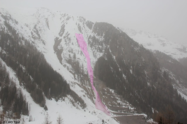
Einsatzkräfte auf der Lawine (c) Landeswarnzentrale Tirol
Rescue team at the Zwölferkopf avalanche  (c) Landeswarnzentrale Tirol


Lawinenabgänge vom 18.03.2022 unterhalb des Zwölferkopfes. Die Pfeile zeigen jeweils die Einfahrtsspuren. (Foto: 19.03.2022)
Avalanches on 18.03.2022 below the Zwölferkopf. Arrows point to the entry tracks. (photo: 19.03.2022)

Friday 18 March 2022

Fresh snow / Dust from the Sahara

Water seepage into the snowpack leads to avalanches


We have landed in springtime, with a pronounced wet-snow problem. The cause is to be found in the weather and warm temperatures, (diffuse) radiation, dust from the Sahara and relatively high air moisture. Thereby, the snowpack becomes moister and wetter from day to day up to ever higher altitudes. It loses its firmness. Subsequently increasingly frequent wet loose-snow, slab and glide-snow avalanches release. Most often they are naturally triggered and of medium size. But small releases are often observed which in their plummet path sweep along greater masses of snow with them, ultimately reaching dangerously large size by the time they stop.


Spontanes Schneebrett auf ca. 2100m, Ost vom 16.03.2022 im hinteren Kaunertal (Foto: 17.03.2022)
Naturally triggered slab, 2100m, E, 16.03.2022, rear Kaunertal (photo: 17.03.2022)


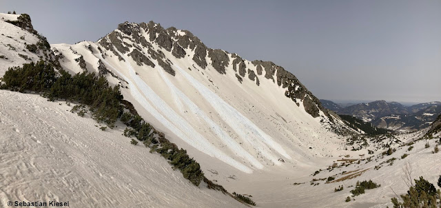
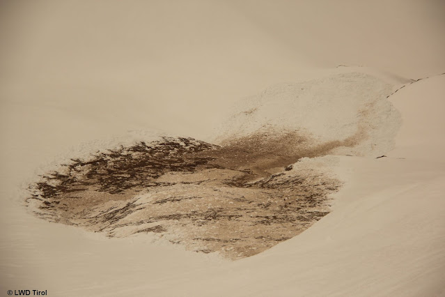
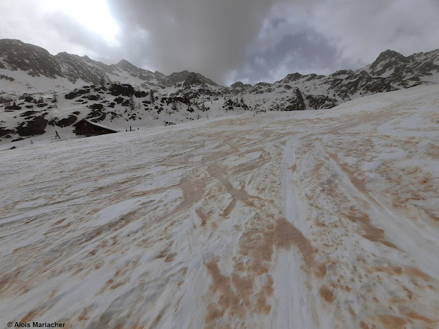
Lockerschneelawinen im Außerfern. Die Schneedecke ist vom Saharastaub bräunlich gefärbt (Foto: 16.03.2022)
Loose-snow avalanches in Ausserfern. The snowpack is brown-colored from Sahara dust. (photo: 16.03.2022) 


Seit dem vergangenen Wochenende beobachtet man wieder eine deutliche Zunahme an Gleitschneelawinen. Mehr Wassereintrag bis zum Boden bedeutet geringere Reibung und dadurch erhöhte Wahrscheinlichkeit solcher Lawinenabgänge. Häufig künden sich diese durch Risse in der Schneedecke an. Aktuell gehen sie gehäuft auch ohne vorangegangene Rissbildung ab. Westliche Tuxer Alpen (Foto: 15.03.2022)
Since last weekend there has been a significant increase in glide-snow avalanches. More water seepage down to the ground means less friction and heightened likelihood of such releases. Frequently they are announced by glide cracks in the snowpack surface. Currently they are releasing even without these bellwethers. Western Tux Als (photo: 15.03.2022)


Der Verlauf der Oberflächentemperatur wurde während der vergangenen Tage immer flacher. Kaum bis wenig Ausstrahlung während der Nacht. Fortschreitende Durchnässung der Schneedecke
The course of surface temperature development became ever flatter over the last few days. Outgoing longwave radiation aduring the night was either little or minimal. The snowpack is becoming wetter ongoingly.


Die Temperatur geht ab den Nachtstunden zurück. Der Himmel bleibt jedoch bedeckt. Der Temperaturrückgang ist in Osttirol ausgeprägter als in Nordtirol.
Temperatures recede as of nighttime. Skies remain cloudy, however. The dropping temperatures in East Tirol are more pronounced than in North Tirol.


Loose-snow avalanches don’t only trigger in extremely steep sunny terrain, but also wherever the snowpack surface is expansively metamorphosed, faceted (like last weekend) and thus, quite loose. Increasingly this was the case on shady slopes at intermediate and high altitudes in wind-protected terrain. Slab avalanches are currently triggering at altitudes between 2000 and 2600 m.


Nasse Lockerschneelawine aus extrem steilem, lichten, schattigen Waldbereich. Ötztal (Foto: 16.03.2022)
Wet loose-snow avalanche in extremely steep, shady sparsely wooded area. Ötztal (photo: 16.03.2022)


Wow! Dust from the Sahara!

The forecast Sahara dust arrived in massive amounts. Wherever it rained on 15-16 March got more Sahara dust and the snowpack was shaded to deeper colors.


Nirgends regnete es während der Nachtstunden vom 15.03. auf den 16.03. viel. Dort, wo es etwas mehr war, wurde mehr Saharastaub abgelagert.
It didn’t rain a great deal anywhere during the night of 15-16 March. Where there was more rainfall, there was more Sahara dust deposited.


Links im Bild ist Süden: Von dort kam am 15.03. der Saharastaub zu uns. Der Himmel war zum Fotozeitpunkt im Süden durch Saharastaub dünkler als im Norden. Dies spiegelte sich an der Schneeoberfläche wieder (Foto: 15.03.2022)
To the left is south, from there on 15.03 the Sahara dust came our way. Skies in southern regions were darker than in the northern regions at the moment the photo was taken. This was also reflected in the colouring of the snowpack surface. (photo: 15.03.2022)


Alles andere als alltäglich!
Hardly an everyday sight!


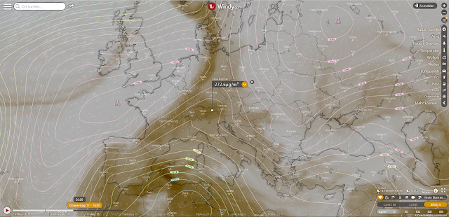
Windy.com: Saharastaubverteilung in der Atmosphäre: Donnerstag, 17.03. 16:00 Uhr
Windy.com: Sahara dust distribution in the atmosphere on Thursday, 17.03 at 4:00 pm


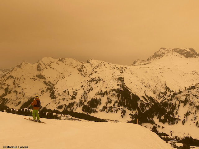
Bild ohne Filter: Saharastaub im Arlberggebiet (Foto: 15.03.2022)
 Photograph without a filter: Sahara dust in the Arlberg region (photo: 15.03.2022)


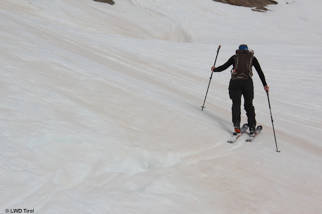
Saharastaub färbt die Schneedecke. Deferegger Berge (Foto: 17.03.2022)
Sahara dust paints the snowpack. Deferegger mountains (photo: 17.03.2022)


The snowpack

Currently there are “temperature reserves” only at high altitudes on shady slopes and on sunny slopes above 2800m. The snowpack is moist-to-wet everywhere else. This situation is not expected to change anytime soon, the sky will remain overcast at least until tomorrow, 18.03. The outgoing radiation will remain much reduced. On the snowpack surface there will be only a thin melt-freeze crust, to the extent that there is any crust at all. Only at high altitudes are conditions better.


Saharastaub färbt die Schneedecke. Deferegger Berge (Foto: 17.03.2022)
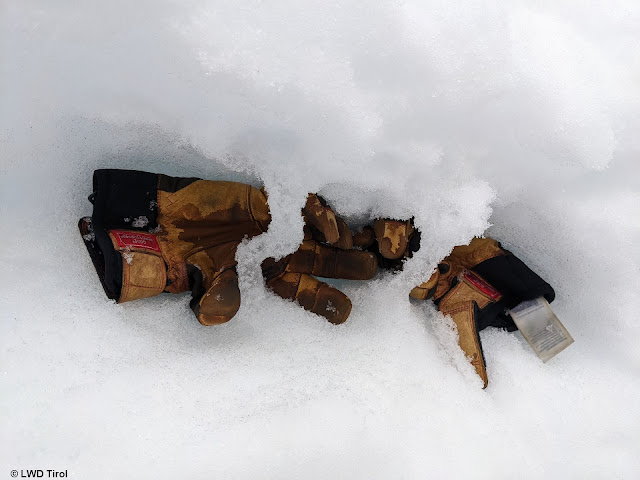
One repeatedly broke through the snow even in the morning at about 2700m. Glockturm Massif
(photo: 17.03.2022) 


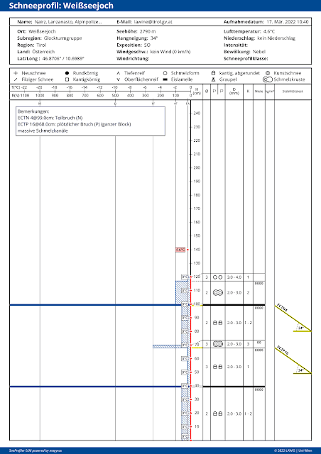
Die Schneedecke ist isotherm (rote, gerade Temperaturlinie). 2790m, SO. Eine recht locker aufgebaute Schneedecke.
The snowpack is isotherm (red, straight temperature line), 2790m, SE, 34°. A very loosely structured snowpack.


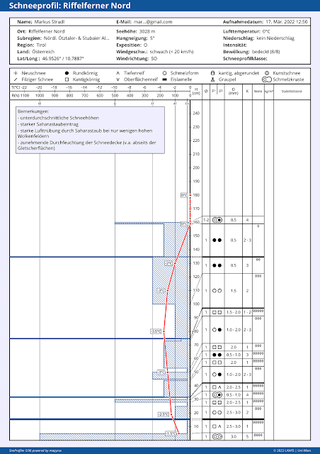
Etwas Temperaturreserve im hochalpinen Gelände. 3030m, O, 5°. Profil vom 17.03.2022
Some temperature reserves in high alpine terrain. 3030m, E, 5°. Profile from 17.03.2022 


In Sonnenhängen findet man häufig (noch) gefrorene Wasserkanäle. Teilweise haben diese noch stabilisierende Wirkung, welche durch Nässeeintrag jedoch abnimmt. (Foto: 17.03.2022)
 On sunny slopes there are often (still) frozen water canals. In some places they exercise a stabilizing effect. This decreases when water seepage occurs. (photo: 17.03.2022)


Increasingly, classic springtime conditions with daytime cycle of avalanche danger

Starting this weekend, the air is expected to become drier. The dust from the Sahara will diminish, the skies will become clearer. Quite classic springtime conditions, including a daytime danger cycle, will take over. We recommend careful planning of backcountry tours and strict time allotment. The higher you go, the more favorable avalanche conditions become.

Monday 14 March 2022

Heed daytime cycle of avalanche danger & small drifts in foehn lanes

Increasingly weakened snowpack due to water seepage


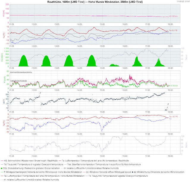
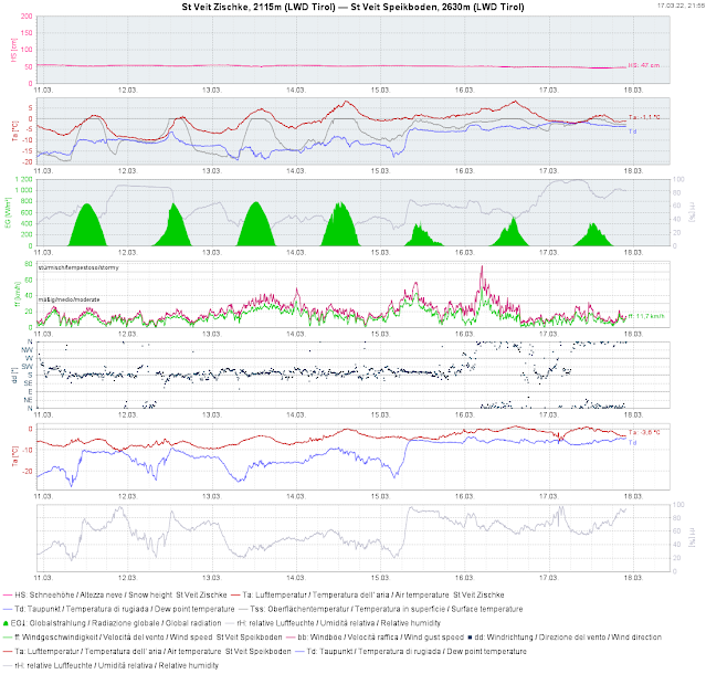
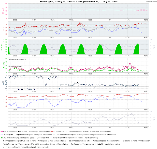
The time window of nearly perfect conditions and low avalanche danger, for the moment, is over. Springtime is making itself felt. That means the snowpack is becoming moister by the day, due to rising temperatures, increasing air moisture and solar radiation (sometimes diffuse). This process is still heavily dependent on aspect, altitude and gradient. Quite indicatively, small changes in the weather are generating huge effects in avalanche danger levels. According to ZAMG Weather Service forecasts, tomorrow (Tues. 15.03) and day after tomorrow (Wed. 16.03) will get intermediate-to-high altitude layers of cloud to start with and subsequently more longwave outgoing radiation. In short: the snowpack can become superficially moistened and thereby weakened very quickly (in some circumstances also on shady slopes down to intermediate altitudes). This can be properly assessed only on-site in outlying terrain, but the weather station data is helpful, particularly a glance at the surface temperature and the thawing point.


Es wird vorerst von Tag zu Tag wärmer. Temperaturverlauf in verschiedenen Höhenniveaus von Sonntag, 13.03. bis Donnerstag 17.03.2022
To start with, it keeps getting warmer day by day. Temperature at various altitudes from Sunday 13.03 til Thursday 17.03.2022.


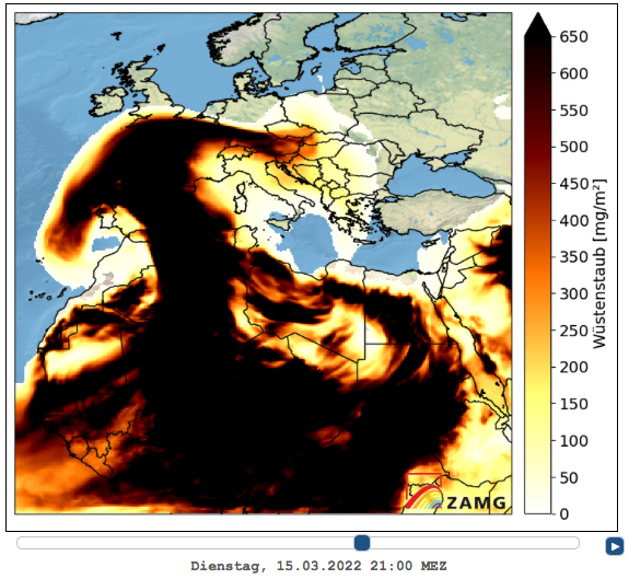
What makes this situation worse is that during the nocturnal hours on 14-15.03 the anticipated sand/dust from the Sahara will arrive, which will heighten outgoing radiation.


Sahara dust moving northwards from the south


Die Belastung von Saharastaub in der Atmosphäre nimmt im Tagesverlauf weiter zu.
The overload in the atmosphere from Sahara dust will increase during the course of the day.


Die wichtigsten Parameter für die kommenden Tage finden sich in der 2.Grafik von oben: Lufttemperatur (rot), Oberflächentemperatur (grau), Taupunkt-ein Feuchtemaß (blau). Darunter in grün die Globalstrahlung in W/m². Zu beachten: Diese Parameter werden im Flachen gemessen. In steilen Sonnenhängen geht die Durchfeuchtung und Durchnässung klarerweise rascher vor sich.
The most important parameters for the next few days can be seen in the second graph above: air temperature (red), surface temperature (gray), thawing point - a measure of moistness (blue). Beneath that in green: the global radiation in W/m². Please note: these parameters are measured in flat terrain. In steep sunny terrain the degree of moisture and wetness is proceeding very rapidly.


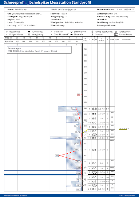
Simulation des Schneedeckenaufbaus mit Hilfe des Schneedeckenmodells SNOWPACK. Selber Standort wie bei der oberen Wetterstationsgrafik (Sonnbergalm oberhalb von Obergurgl). Großer Unterschied: Schneedecke wurde für einen 38° steilen Südhang simuliert. Links: Schnitt durch die Schneedecke vom 22.02. bis 12.03.2022: Rote Schichten repräsentieren Schmelzformen. Rechts: Härteprofil der Schneedecke vom 12.03.2022 12:00 Uhr. Die Schneedecke ist bereits isotherm, d.h. bis zum Boden 0°C!
Simulation of snowpack layering with aid of snowpack computer model SNOWPACK. Same location as in the upper weather station graph (Sonnbergalm, above Obergurgl). Big difference: snowpack was simulated for a south-facing slope at 38° of steepness. Left: section of the snowpack from 22.02 until 12.03.2022: red layers represent melt forms. Right: hardness profile of snowpack from 12.03.2022, 12:00 pm. The snowpack is already isotherm, i.e. the snow temperature is 0°C down to the ground.


In tieferen Höhenlagen nähert sich die Schneetemperatur nun auch im flachen Gelände zunehmend der 0°C an. Bei oberen Profil sprechen wir von geringer Temperaturreserve. D.h. ein weiterer Feuchtigkeitseintrag kann rasch zur Durchnässung bis zum Boden und somit zu weiterem Festigkeitsverlust führen.
At lower altitudes the snow temperature also in flat terrain is nearly 0°C. In the above profile we speak of low-temperature-reserves. That means an additional load of moistness can swiftly lead to the snowpack becoming wet down to the ground, which would lead to a further loss of firmness.


Wet-snow avalanches beginning to stir

Since the weekend, isolated reports of wet-snow avalanches have arrived at headquarters. These were nearly all small-sized avalanches, most were loose-snow avalanches, some were slab and glide-snow avalanches. Today (14.03) a small slab avalanche triggered during the descent of 3 winter sports enthusiasts from the ski area Sölden towards Winterstall (Vent valley) in outlying terrain and subsequently developed to a dangerously large-sized wet-snow avalanche. In other words...small cause, big effect. 
-> This is what needs to be kept in mind over the next few days.
 

Lawinenabgang Winterstall vom 14.03.2022. Geringmächtige Schneedecke, die bei einer geringen Schneemächtigkeit bis zum Boden abging. SO, ca. 35°
Avalanche Winterstall on 14.03.2022. Shallow snowpack, released down to the ground. SE, about 35°


Eine Person fuhr am 13.03. orographisch links in den Hang ein. Man erkennt dort einen schneeärmeren Bereich. Die Person wurde von dem Schneebrett mitgerissen und wurde leicht verletzt. Schafkar, 2300m, SO, 35-40°.
One person skied orographically left into the slope on 13.03. Shallow-snow zone is visible. This person was swept along by the slab and injured slightly. Schafkar, 2300m, SE, 35-40°.


Kleine feuchte/nasse Schneebrettlawinen Rifflsee / Pitztal (Foto: 12.03.2022)
Small moist/wet slab avalanche Rifflsee / Pitztal (photo: 12.03.2022)


Kleine Schneebrettlawine vom 14.03. Lampsenspitze, Nördliche Stubaier Alpen. Man erkennt eine Einfahrtsspur.
Small slab avalanche on 14.03. Lampsenspitze, northern Stubai Alps. Entry track is visible.


Caution: small snowdrift patches on shady slopes, esp.in the classic foehn lanes

During the last few days, a quite strong southerly foehn wind raged. Most struck were the typical foehn lanes, e.g. Wipptal and the bordering regions, once again. The loose snow on expansively metamorphosed (faceted) shady slopes was transported, and subsequently deposited precisely atop this weak layer in wind protected zones. Mostly small but very prone-to-triggering snowdrift accumulations were generated. The danger of falling outweighed the danger of being buried, for the most part. Nevertheless: such danger zones are still prone to triggering, though they are easy to recognize with adequate experience.


Kleinräumige Triebschneepakete im Wattental in den Tuxer Alpen (Foto: 11.03.2022)
Small snowdrift masses in Wattertal, Tux Alps (photo: 11.03.2022)


Bei Südföhn einer der windanfälligsten Standorte Tirols - der Patscherkofel
When southerly foehn wind is blowing, this is one of the most vulnerable spots in Tirol - Patscherkofel


Our appeal: please heed the daytime cycle of avalanche danger and the nighttime outgoing radiation of the snowpack.

What seems most important is this: grasping the time of day and its effect on avalanche danger. The clearer the skies, the lower the temperature, the drier the air, the more favorable the situation during the early morning hours. On the other side, and that is what counts in the next few days: the higher the temperature, the moister the air (i.e. the more cloud cover during the night), the more unfavorable are conditions during the early morning hours. Avalanche danger then increases very swiftly during the course of the day. Good backcountry tour planning and allotment of time are the keys to success during the coming days.

Friday 11 March 2022

Danger of falling on frozen surfaces outweighs avalanche danger

Favorable avalanche situation, generally low danger


All week long, extremely steep terrain was skied throughout Tirol without avalanches getting triggered. At the same time, stability tests have shown a snowpack which is low in tensions, highly stable. In short: this is a favorable avalanche situation.

Very few avalanche prone locations

Dry loose-snow avalanches in extremely steep shady terrain

The snowpack surface became expansively metamorphosed to a massive degree during the extended period of beautiful weather. That means it often consists of loose, faceted crystals. In extremely steep terrain the impulse of skiing can threaten loose-snow avalanches. The danger of being swept along outweighs that of being buried in snow masses. Experts refer to “sluff management” in this connection: either you give the loose-snow avalanche enough time to release beneath your track or you take care that you don’t get in the path of the plummeting snow masses.


Ein Wintersportler löste unmittelbar zuvor während der Abfahrt die am Bild ersichtlichen Lockerschneelawinen aus, die ihn während seiner Weiterfahrt nicht gefährdeten. Silvretta (Foto: 08.03.2022)
A winter sports enthusiast triggered this loose-snow avalanche just prior, during his descent, which did not endanger him. Silvretta  (photo: 08.03.2022)


Moist loose-snow avalanches primarily from the impulse of winter sports enthusiasts
 
All week long, it was too cool for this juncture of the season. In addition, the air was often very dry. Both these things led to the snowpack on steep sunny slopes becoming only slightly moist during the daytime. Moist loose-snow avalanches thereby occurred, if at all, only later in the day by the impulse of skiers. As a result of slowly rising temperatures during the week, it is becoming more likely that isolated moist slides will trigger naturally in extremely steep terrain during the course of the day.


Ein kleiner feuchter Rutsch im extrem steilen, nach Süden ausgerichteten Gelände. Ötztaler Alpen (Foto: 10.03.2022)
A small moist slide in extremely steep south-facing terrain. Ötztal Alps. (photo: 10.03.2022)


Mostly high-quality snow

As flawless as the snow was at the beginning of last week it no longer is, but generally the snow quality is still high: in flat and generally shady terrain the surface is often loose. On steep sunny slopes the surface is hard-frozen in early morning, then softens up during the day. The joys of firn snow are coming to those zones. In high alpine regions the wind was frequently in play.
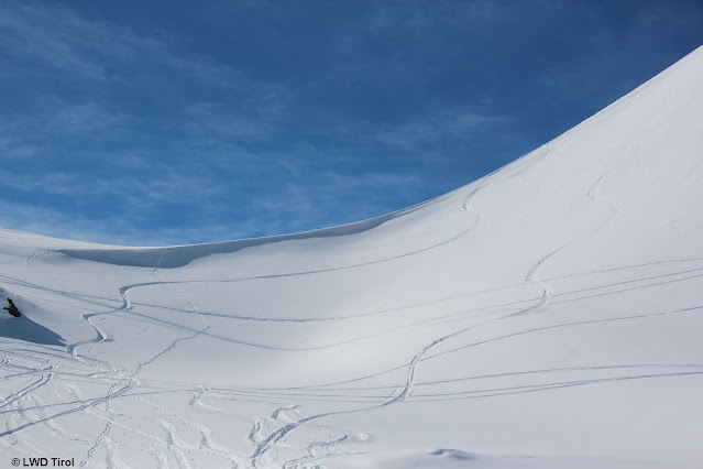

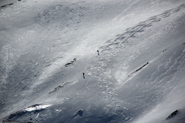
Betrachtet man die zwei von rechts kommenden Skispuren so lässt sich erkennen. Sonnseitig Firn, schattseitig "Pulver". (Foto: 08.03.2022)
Look at the two ski tracks coming from the right: firn on sunny slope, “powder” on shady slope
 (photo: 08.03.2022)


Ein "Pulvertraum". Ötztaler Alpen (Foto: 10.03.2022)
A dream of powder snow. Ötztal Alps (photo: 10.03.2022)


Die Übergangsbereiche mit Bruchharsch nehmen langsam zu. (Foto: 08.03.2022)
Transition zone with melt-freeze crusts gradually increasing. (photo: 08.03.2022)


Büßerschnee entsteht im Frühjahr dann, wenn die Luft sehr trocken ist. Sellrain (Foto: 06.03.2022)
“Ragged snow” forms in springtime when the air is very dry. Sellrain (photo: 06.03.2022)


Other alpine dangers

Currently, other alpine dangers outweigh those of avalanches. Among these number the danger of slipping on the frozen snowpack which freezes hard during the night, and being forced to take a fall.

We have also received information about cornices breaking. Caution is urged particularly in traversing ridges. But also stopping below a cornice is dangerous.
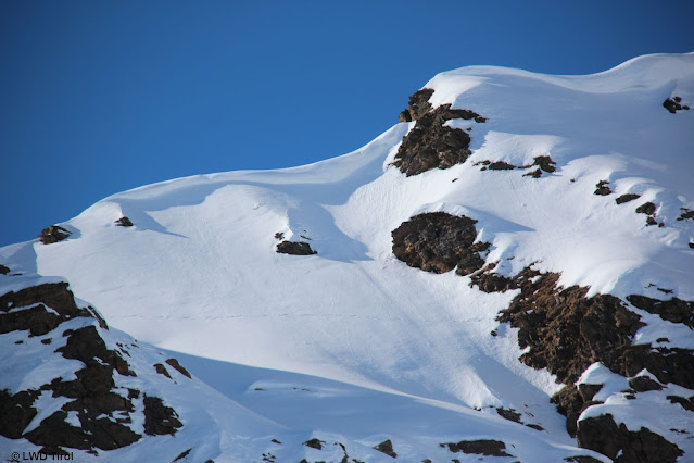

Wechtenbildung im Kammbereich (Foto: 08.03.2022I
Cornice formation near ridge (photo: 08.03.2022I


Ausrutschgefahr auf Eisgallen (Foto: 10.03.2022)
Danger of slipping atop ice (photo: 10.03.2022)


Weather review and outlook

To put it into a nutshell: all week long, high-pressure front conditions dominated. Sometimes there was cloud, in the Lower Inn Valley in particular. It will continue. More clouds will be evident over the short term in East Tirol It will remain dry. Temperatures will gradually rise.


Das Unterland war Anfang letzter Woche wettertechnisch etwas benachteiligt. Seit 08.03. dann wieder sternenklare Nächte bei trockener Luft. Die Temperatur steigt nun von Tag zu Tag etwas an. Dieser Trend hält an. Die Schneeoberfläche wird während des Tages feucht.
Tirol’s lowlands were at a slight disadvantage at the beginning of last week. Since 08 March, nighttime skies were again star-studded, the air dry. Temperatures are now climbing a bit each day. This trend will continue. The snowpack surface will become moist during the daytime.


The favorable avalanche situation will persist!

Friday 4 March 2022

Mostly favourable avalanche situation, only few danger zones

 Snowpack with few tensions

Snowpack analysis and reports from the field reveal that the snowpack is generally low in tensions in the interim. For that reason this blog will deal primarily with the positive aspects of the situation. On shady slopes there is powder for skiing widespread, while on sunny slopes at least up to intermediate altitudes there are firn-like conditions in many places.


Lockerer, aufbauend umgewandelter Schnee - quasi Pulverschnee - v.a. in nordexponierten Hängen; Tuxer Alpen (Foto: 03.03.2022)
Loose, expansively metamorphosed snowpack surface, just like powder, especially on north-facing slopes. Tux Alps (photo: 03.03.2022)


Powder snow in Arlberg region (photo: 27.02.2022)


Sulzschnee im besonnten Gelände in mittleren Höhenlagen (Foto: 03.03.2022)
Corn snow in sunny terrain at intermediate altitude. Tux Alps (photo: 03.03.2022)


Many winter sports enthusiasts have been observed in backcountry during this period of beautiful weather.


Ein recht häufiges Bild: Stark verspurtes Gelände auf beliebten Skitourenzielen. Tuxer Alpen (Foto: 03.03.2022)
A frequent sight: heavily tracked snow in popular backcountry skiing zones. Tux Alps (photo: 03.03.2022)


Few danger zones

Currently we assume that there are only few avalanche prone locations in outlying terrain, where avalanches can be triggered and skiers/boarders are in danger.

The persistent weak layer so often spoken about in recent blogs, caused by weak layers at mid-level in the snowpack, is now limited to the following:
  • mostly above 2400m
  • triggering possible in very steep, more likely in extremely steep terrain
  • triggering most likely where snow is shallow and in transitions from shallow to deep snow in the vicinity of so-called nests of depth hoar
  • terrain hardly touched/tracked during the winter
  • increasingly on north-facing slopes; in high-alpine regions (above 3000m) also on sunny slopes in isolated cases
The avalanches which trigger are frequently medium-sized.


Bei diesem Schneebrett im Rettenbachtal wurde eine Person am 24.02.2022 verletzt. (Foto: 25.02.2022)
One person was injured in this slab avalanche in Rettenbachtal on 24.02.2022. (photo: 25.02.2022)


Profil, welches bei der oben abgebildeten Lawine im Rettenbachtal aufgenommen wurde. Oberer Teil der Schneedecke in "hellerem weiß". Unterer Teil der Schneedecke in "mattere weiß". Unten ist diese massiv aufbauend umgewandelt ("Schwimmschneenest"). Dort, wo diese Schicht noch von einem ausreichenden "Brett" überlagert ist, könnte ein Bruch initiiert werden. (Foto: 25.02.2022)
Profile from above avalanche in Rettenbachtal. Upper part of the snowpack in “bright white” - lower part in “flat white.” The lower part is expansively metamorphosed to a high degree (nests of depth hoar). Where this layer is blanketed by a slab of sufficient size, a fracture could be initiated. (photo: 25.02.2022)

In addition, we assume that in a narrow altitude band around 2600m in very steep sunny terrain, due to Danger Pattern 4 (cold on warm) there is a thin, faceted layer beneath the snow which fell (and was transported) on 25.02 and 26.02. An avalanche near Prager Hütte (Venediger Massif) on 28.02 on a steep (at least 35°) west-facing slope at 2600m and another at Schrimmennieder (northern Stubai Alps), likely on 02.03 on an equally steep west-facing slope at 2650m, were probably unleashed in this layer.


About 2500m, SW, 40°, Tux Alps. A thin, faceted layer near the surface which probably formed as of 26.02. Profile taken on 03.03 in Tux Alps.


The snow which fell on 25-26 February was transported by cold NE winds. The snowdrift accumulations can still be easily identified in outlying terrain.


Lawinenabgang Schrimmennieder (Foto: 03.03.2022)
Avalanche Schrimmennieder (photo: 03.03.2022)


Isolated “cold” glide-snow avalanches also released last week. One of them caught a person on his way to Namloser Wetterspitze, another led to an exploratory flight to the southern flank of the Nockspitze. Today (03.03) daytime warmth and, even more, moistness of the snowpack seem to have led to more extensive “warm” glide-snow avalanches on very steep sunny slopes at intermediate altitude.


Eine Gleitschneelawine, die sich am Egger Muttekopf löste und Skitourengeher im Aufstieg zur Namloser Wetterspitze teilweise verschüttete. (Foto: 27.02.2022)
A glide-snow avalanche that triggered on Egger Muttekopf and partially buried a backcountry skier ascending to Namloser Wetterspitze (eastern Lechtalers Alps). (photo: 27.02.2022)

  
Diese Gleitschneelawine unterhalb der Nockspitze führte aufgrund einer Einfahrtsspur, die unten nicht unmittelbar ausgemacht werden konnte, zu einem Lawineneinsatz. (Foto: 02.03.2022)
This glide-snow avalanche below the Nockspitze (northern Stubai Alps) led to an avalanche rescue operation due to an entry track which could not be found below the avalanche. (photo: 02.03.2022)


Vorsicht vor Gleitschneerissen / -mäulern. Bei zunehmender Durchfeuchtung erhöht sich die Wahrscheinlichkeit eines Abgangs. (Foto: 28.02.2022)
Caution urged towards glide-cracks and “wishbones” on the surface. As moistening increases, the likelihood of a release rises. (photo: 28.02.2022)


Short weather review

Last week there was snowfall on 25 and 26 February, mostly 10 cm, up to 30 cm from place to place. Due to the low temperatures the snow was rather loose and was transported by quite strong N/E winds. All in all, high-pressure front conditions dominated. The snowpack cooled off well during the nocturnal hours. Due to the low temperatures and very dry air masses the snowpack never became thoroughly wet, simply superficially moist on sunny slopes up to intermediate altitudes.


24h Schneehöhendifferenz vom 25.02. auf den 26.02.
24-hr snow depth difference from 25.02 to 26.02


Wetterrückblick anhand der Wetterstation Seegrube. U.a. wurde die Schneeoberfläche im flachen Messfeld nie feucht.
Weather review seen from Seegrube weather station. Note: the snowpack surface in this flat measuring zone never became moist.


What we can expect...

According to ZAMG Weather Service, no significant snowfall is anticipated in the immediate future. Temperatures are too low for this juncture of the season. The weekend promises lots of sunshine.

Thus, we can count on a predominantly favourable avalanche situation for a while yet.