To start off
Mild weather during the next few days is intensifying the wet-snow problem. Wetness seeping into snowpack is weakening it. Avalanches can more easily be triggered by winter sports enthusiasts. Also naturally triggered avalanches are more likely. Crucial: good tour planning, reasonable time allotment, adequate equipment and experience in assessing avalanche danger on-site.
A pronounced slab is developing
As we all know, several ingredients are necessary for slab avalanches: at least one weak layer inside the snowpack; on top of that a “slab” - in other words, a bonded mass of snow; in addition, the terrain must be steep enough for the slab to release, i.e. be ejected. This steepness gradient typically lies at 30°. Variable weather recently brought us several batches of fresh snow. Strong winds transported it and generated wide-ranging snowdrift accumulations. An added injection to fresh snow and drifts bonding was supplied by diffuse radiation and higher temperatures. It all adds up to one thing: a highly pronounced slab.
 |
| 48-hr snow difference 13.03.-14.03. |
.jpg) |
| Diffuse radiation, high air moisture enhance slab formation. (photo: 11.03.2023) |
Weak layers further weakened by water seepage
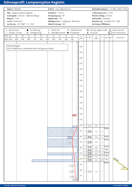
Weak layers inside the snowpack are currently (15.03) likeliest to trigger on shady slopes at 2000-2400m, and on west-facing and east-facing slopes above 2400m. East-facing and northeast-facing slopes above 2500m appear to be the least favorable of all. The reason for this lies in the expansively metamorphosed weak layers inside the snowpack (faceted crystals, depth hoar). On shady slopes, we see increasing water seepage down to the ground-level layers. On sunny slopes the snowpack became thoroughly wet much too often in this overly mild winter. Ground-level weak layers were thereby “activated” up to high altitudes on south-facing slopes, but also on west-facing and east-facing slopes up to about 2400m. For that reason we focused on the west-facing and east-facing slopes above 2400m, since they are becoming thoroughly wet for the first time. East-facing and northeast-facing slopes are more critical because there are more expansively metamorphosed layers near the surface beneath a melt-freeze crust whose enormity depends on altitude and steepness.
 |
| The red line denotes snow temperature. At 2140m North, temperature reserves are very low. That means, with a bit more warmth, the snowpack will swiftly become thoroughly wet down to the ground. |
Increased avalanche activity
Following several rounds of snowfall and subsequent solar radiation, highly frequent loose-snow avalanches can be expected in extremely steep terrain at this juncture of the season. Furthermore, in the regions where snowfall has been heaviest, increasingly frequent glide-snow slides and glide-snow avalanches can be expected on steep grass-covered slopes. AND VERY IMPORTANT: slab avalanches can far more easily be triggered by winter sports enthusiasts. As the weekend approaches, naturally triggered avalanches will also become more likely. The next blog will be published tomorrow (16.03). In it the recent avalanches near the Pforzheimer Hütte (each on E/NE facing slopes above 2400m) will be analyzed.
_bearbeitet.jpg) |
| Wet loose-snow avalanche in the Deferegger Alps (photo: 14.03.2023) |