In a nutshell...
Last week was marked by the snowpack becoming increasingly wet up to high altitudes. Numerous avalanches triggered, mostly wet loose-snow and glide-snow avalanches. As a result of highly variable weather conditions the avalanche situation in the morning hours is often very unfavourable up to high altitudes for winter sports enthusiasts. Avalanche danger below 2800m is currently considerable (Danger Level 3).
Wet, wetter, wettest
We are in the middle of a classic wet-snow cycle. Snowpack thickness is below-average for this juncture of the season, and all the way up to heightened altitudes it is now wet down to ground level: on west-facing and east-facing slopes as far up as 2800m, on south-facing slopes higher still, on north-facing slopes it fluctuates between 2200m and 2400m.
 |
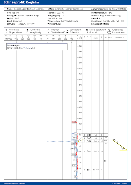
| What interests us most in current snow profiles is the red line: temperature profile. At this location at 2227m on a 22° NE slope the snowpack on 19.03 was already isotherm (snow temperature = 0°). |
 |
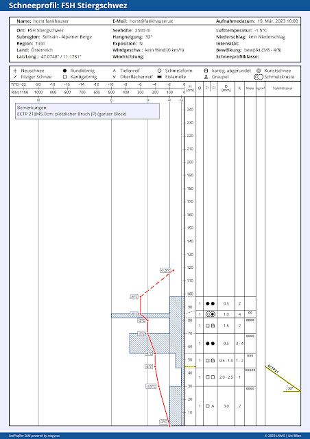
| Temperature profile on north-facing slope at 2500m. There were still reserves of cold on 19.03.2023. |
Precipitation will set in during the course of the day today, 24.03. Initially as rainfall below 2400m, which means that most shady slopes below 2400m will be thoroughly wet down to the ground. Caution: in rain-impacted regions, naturally triggered avalanche releases can be expected particularly on very steep north-facing slopes. The rainfall level will actually be even higher up for a brief time. According to GSA (Geosphere Austria) the snowfall level will drop to about 1700m swiftly. About 10-15 mm of precipitation is expected, somewhat more along the Main Alpine Ridge.
 |
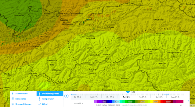
| Fresh snow forecast for tomorrow, 25.03.2023 (forecast made today, 24.03) |
 |
| Cold air masses penetrating from the northwest (which will cause the snowfall level to descend) are visible on this map. |
Avalanche activity last week
.jpg) |
| Limited avalanche activity on 18.03. Typical: wet loose-snow avalanches on extremely steep slopes. Serleskamm |
.jpg) |
| “Shower-room weather” furthered the snowpack becoming thoroughly wet. Visible in the photo are several naturally triggered loose-snow avalanches. Alpeiner Berge (photo: 20.03.2023) |
.jpg) |
| Wet loose-snow avalanches in the Silvretta around midday on 19.03.2023 (photo: 20.03.2023) |
.jpg) |
| Similar situation in Kühtai: naturally triggered and artificially triggered loose-snow avalanches. (photo: 22.03.2023) |
.jpg) |
| Avalanches could intentially be triggered even by one tiny impulse. The snowpack here was thoroughly wet and loose. (photo: 22.03.2023) |
.jpg) |
| Mieming Massif. Avalanche wedge from previously unleashed wet loose-snow avalanches. (photo: 23.03.2024) |
Unique factor of current situation: heavily tracked terrain can be more dangerous
As mentioned above, lots of wet loose-snow avalanches triggered, also attributable to the shallow snowpack. Water quickly made the surface wet, usually consisting of thin, hard layers. The “slab” which is one of the prerequisites for slab avalanches was thereby destroyed. In open terrain which was heavily tracked during the winter (and where ground-level weak layers from early winter persisted) this “slab” is more pronounced and more massive. Thus, when it becomes thoroughly wet, slab avalanches are likelier to trigger. A paradox, that heavily tracked terrain is currently more dangerous than little-tracked terrain.
Following today’s (24.03) precipitation mentioned above, tomorrow will bring us April weather: diffuse solar radiation in a powerful westerly air current. The fresh fallen snow will trigger frequent small loose-snow avalanches in extremely steep terrain. What is important everywhere: the ongoing wetness of the snowpack amplified by diffuse radiation. Particular caution is urged on shady slopes at 2200 to 2400m, even higher from place to place. In short: conditions remain unfavorable, both in terms of avalanche danger and in terms of snow quality.
Starting on Sunday, 26.03, things will turn wintery again. During Sunday morning, snowfall up to 1600m is expected in some regions. On Sunday night (wee hours of 27.03) we can expect storm winds at high altitudes and some snowfall down to low lying areas, according to GSA Weather Service. What follows then can only be assessed after the coming perturbance has left its mark.
