Summing it up
Several avalanches have been triggered by winter sports enthusiasts during the last few days, increasingly on very steep slopes above 2500m in NE/E/SE aspects. The heightened proneness to triggering of weak layers inside the snowpack was the result of pronounced slabs (see last blog) which formed recently. Most avalanches releases were caused by a persistent weak layer (long-enduring, hard-to-recognize weak layer inside the snowpack). In one avalanche accident near the Scheid in the Samnaun Massif, a winter sports enthusiast died today in backcountry terrain. In other avalanches in recent days, persons were also injured.
As always in springtime, small shifts in weather can have huge and swift effects in avalanche danger. Major factors, apart from air temperature and (diffuse) solar radiation, include in particular air moisture. And of eternal importance: whether nocturnal outgoing radiation is impeded by clouds. Therefore, pay close attention in open terrain to the degree of wetness of the snowpack. This leads to loss of firmness and a rapid increase in avalanche danger.
Fatal avalanche accident in Samnaun Massif
Today (17.03.2023) a winter sports enthusiast lost her life in open skiing terrain in the vicinity of the upper Scheid Lift (ski area Serfaus, Fiss, Ladis) in an avalanche. The slab avalanche triggered when she descended in backcountry ski terrain down an extremely steep NE-facing slope. The fracture occurred at 2550m. She was caught by the avalanche and completely buried in snow masses. She had no beamer. Following an extensive search including avalanche dogs, she was finally found lifeless. The problem which caused the avalanche was a persistent weak layer. Tomorrow (18.03.2023) we will carry out a thorough and detailed snowpack/avalanche analysis together with the Alpine Police (snow profiles will be published on Lawis).
_bearbeitet_1.jpg) |
| Avalanche accident Scheid, 17.03.2023. Arrow points to the entry track, circle is where she was buried. (photo: 17.03.2023) |
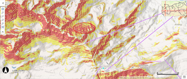 |
| Ellipse shows area of avalanche. It is extremely steep terrain. Violet: lifts of the ski area Serfaus, Fiss, Ladis |
.jpg) |
| Entry zone including a part of avalanche fracture (photo: 17.03.2023) |
Other reported avalanches of this week
During this week, a number of avalanches were reported to headquarters Tirol. What stands out (please note this in planning tours) is that most occurred on NE/E/SE-facing slopes above 2500 m. Here is the list:
09.03.2023: Pflerscher Pinggl, central Stubai Alps: no one buried
11.03.2023: Hoher Seeblaskogel, Sellrain, Alpeiner B.: no one buried
12.03.2023: Litnisschrofen, Allgäu Alps: no one buried
12.03.2023: Galtenberg, western Kitzbühel Alps: no one buried
12.03.2023: Breite Scharte, Sellrain, Alpeiner Berge: NO, 2500m (persistent weak layer), 1 person totally buried, injured
12.03.2023: Hoher Burgstall, Sellrain, Alpeiner Berge: NO, 2500m (persistent weak layer), 1 person swept along, not buried
13.03.2023: Murkarspitze, Sellrain, Alpeiner Berge: no one buried
13.03.2023: Hintere Neder, northern Zillertal Alps: no one buried
13.03.2023: Walfeskar, Sellrain, Alpeiner Berge: SO, 2750m (persistent weak layer), 1 person partly buried, injured
13.03.2023: Zwölferkopf, Samnaun Massif; NW, 2500m: no one buried
15.03.2023: Alblittköpfe, eastern Verwall Massif: NO 2500m (persistent weak layer), 1 person buried, injured
15.03.2023: Eisgrat, central Stubai Alps: SO, 2860m (snowdrift problem), no one buried
15.03.2023: Hinteres Rendl, western Verwall Massif: no one buried
15.03.2023: Mitterkarspitze, western Verwall Massif: no one buried
15.03.2023: Grawa, central Stubai Alps: no one buried
16.03.2023: Riefenkopf, Samnaun Massif: NO, 2600m, (persistent weak layer) 2 persons, no injuries
16.03.2023: Rostocker Eck, Venediger Massif: no one buried
16.03.2023: Weißseejoch, Glockturm Massif: N, 2500m, no one buried
17.03.2023: Scheid, Samnaun Massif: NO, 2550m (persistent weak layer), 1 person dies
17.03.2023: Riffljoch, Glockturm Massif: no one buried
17.03.2023: Tiefenbachferner, Weisskugel Massif: SO, 3000m (snowdrift problem), no one buried
17.03.2023: Gaiskogel, Kühtai-Geigenkamm: NW, 2580m, no one buried
Here are some photos of selected avalanches:
.jpg) |
| Several slab avalanches triggered naturally last week, particularly in the western part of North Tirol. Western Verwall Massif (photo: 15.03.2023) |
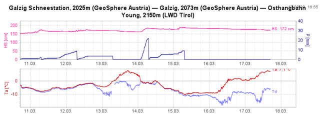 |
| Repeated bouts of precipitation and fluctuating temperatures enhanced snowpack’s proneness to triggering |
Springtime comes knocking - Heed daytime-induced cycle of avalanche danger
To round out our last blog we would like to devote some attention to the anticipated further development of conditions. Tomorrow (Saturday, 18.03) will be a complex weather situation. Air temperature will recede somewhat from today’s (17.03) levels and the air will become more moist. Dust blown up from the Sahara Desert will fill the skies. On steep west-facing slopes it may still occur in the afternoon that water seeps down to deeper layers. Expansively metamorphosed (faceted, often encrusted) weak layers could be weakened still further and the snowpack could become prone to triggering.
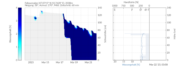 |
| Our “Snowpack” model shows that water on a simulated 38° gradient west-facing slope at Falkaunsalpe Station in Kaunertal will seep down to ground-level layers tomorrow (18.03). |
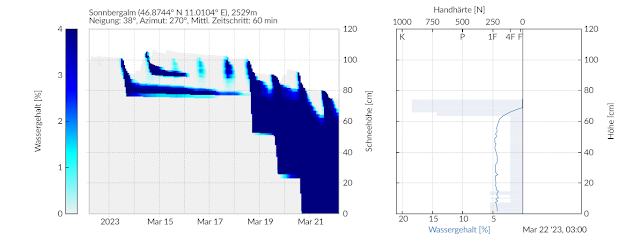 |
| At the higher Sonnbergalm Station in the Gurgler Massif, water seepage down to the ground will take somewhat longer, on a simulated 38° gradient slope. |
_bearbeitet_1.jpg) |
| Through the impulse of a naturally triggered wet loose-snow avalanche, a slab avalanche was triggered today (17.03) at 11:30 am. East-facing slope, 2750m. Steintalspitze, Kühtai |
On Sunday, all signs point to a brief pause in spring, according to current weather forecasts. A minor perturbance will make the zero-degree level descend to 2000m. The sun will presumably be shaded. Next week, mild weather will return and continue.
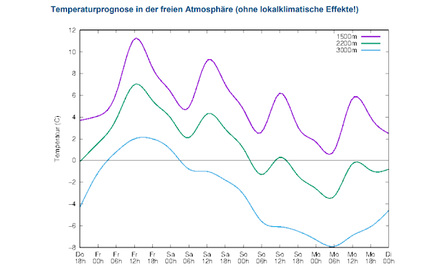 |
| Temperature development in coming days. Today (17.03) was the warmest. |
 |
| A week full of fluctuations, wildly varied leaps of temperature, repeated bouts of precipitation (snow and rain) including lots of wind in places, is coming to an end. |
Don’t forget: last week also offered winter sports enthusiasts some good powder.
.jpg) |
| Powder widespread in Tirol, which will become rarer day by day due to diffuse radiation. (photo: 15.03.2023, (c) Lukas Ruetz) |
The upshot
Pay close attention to the moistness of the snowpack. Focus on the devilishly tricky persistent weak layer problem. It starts at 2200m on shady slopes, above 2400m on east-facing and west-facing slopes, especially where snowfall has been heaviest. Caution urged on little-tracked very steep terrain.
.jpg) |
| Snowpack analysis, the foundation of our work. (photo: 15.03.2023, (c) Lukas Ruetz) |
_bearbeitet_1.jpg)
_bearbeitet_1.jpg)
_bearbeitet.jpg)
.jpg)
.jpg)