Abundant fresh snow and storm winds: avalanche danger rises to “high”
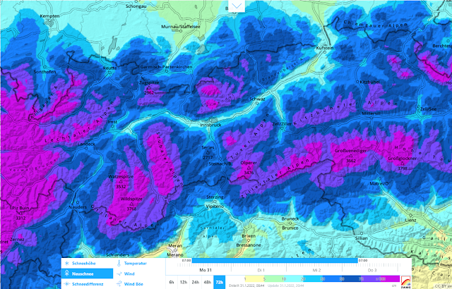
The cold front forecast by ZAMG Weather Service arrived at midday today, 31.01, and is already bringing intensive snowfall to far-reaching parts of North Tirol. In addition, strong-to-storm strength NW winds are raging in the mountains. By the end of the day on Wednesday, 80 to 130 cm of new snow can be expected, according to the latest forecasts. The focal point will be on the Silvretta-Arlberg region and the Lechtal Alps to Karwendel, according to ZAMG, with 130 up to 180 cm from place to place possible. Least snowfall is expected in southern East Tirol: about 20 cm.
 |
| 72-hr new snow forecast starting Monday, 31.01.2022 |
The precipitation will come in two bouts, the first by a cold front from Monday to Tuesday, followed by a brief interim on Tuesday afternoon. The second round will be brought by a warm-active front starting on Tuesday evening and continue through Wednesday.
 |
 |
| Clearly depicted: arrival of cold front, 31.01 midday, as snowfall begins amid strong-to-stormy winds. |
For Tuesday, 01 February, we initially expect a delicate to dangerous situation for winter sports enthusiasts (‘skiers high’ above the timberline). Starting on Wednesday, the big danger will be in connection with large-sized naturally triggered avalanches. In the regions where snowfall is heaviest, we can expect isolated very-large sized avalanche releases during the course of the day, due to rising temperatures.
A peek into the snowpack
As mentioned in the last Blog , a precise analysis of current snowpack layering ahead of a major round of snowfall is essential in order to estimate avalanche danger potential, in particular as regards the type and the magnitude of coming avalanches
We were very fortunate in one respect: there was a large number of high-quality snow profiles to back up our analysis (lawis.at) and, on the other hand, state helicopter flights into outlying terrain enabled us to gain an outstanding picture of the structuring and stability of the snow cover throughout Tirol.
 |
| Snowpack analysis: foundation of good avalanche prognosis. Western Verwall Massif (photo: 25.01.2022) |
Analysis of snow profiles
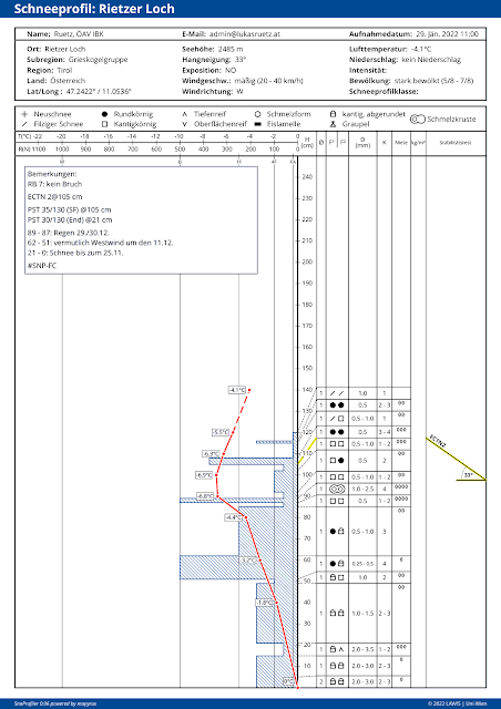
Symptomatic of the current snowpack is its high stability with possible weak layers likeliest in the near-to-surface part beneath thin melt-freeze crusts.
 |
| Snow profile in Griesskogel Massif on 29.01.2022, NE, 2485m, 33°. Stability tests led to only a partial fracture near the surface. |
 |
| Snow profile in western Verwall Massif on 28.01.2022, E, 2610m, 38°. Partial fracture beneath a thin, near-surface melt-freeze crust. |
Highly variable snowpack surface due to immense wind impact
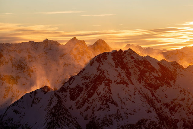
Before the current snowfall set in, there were already strong to storm-strength winds raging in many parts of the land which created massive effects on the snowpack surface, and were also highly varied and irregular. Thus, snow distribution was also hugely disparate. This in itself is positive, since large fracture propagation in the old snow thereby becomes less likely.
 |
| The last few days bear the imprint of strong-to-stormy winds in the mountains. Griesskogel Massif (photo: 29.01.2022) |
 |
| Pirmigspitze in the western Lechtal Alps. The north-facing slope was and is still being massively impacted by wind. (photo: 28.01.2022) |
Wind-protected zones which boast an undisturbed snowpack surface (itself a potential weak layer for slab avalanches) are rare. Most likely to occur on shady slopes at the foot of walls or on (south)east facing slopes or at the foot of cliffs. There the old snowpack is loose, frequently with huge accumulations of graupel from the last few days. In those places, the persistently encrusted surface hoar starting the process of expansive metamorphosis referred to in the (last Blog) can most easily be found.
Weak layers for slab avalanches
These are the realistic possible slab avalanches:
- expansively metamorphosed snowpack surface in wind-protected zones
- loose new snow of recent days in wind-protected zones, e.g. northern East Tirol
- faceted layer beneath surface-near melt-freeze crust
- loose, expansively metamorphosed base of snowpack (most often seen in Glockturm Massif)
- weak layers which form starting at midday today, 31.01. This could be huge deposits of graupel; or also cold new snow which briefly falls amid high wind impact and then is blanketed by drifts or warmer fresh snow from the expected warm-active front on Wednesday.
Outlook
At the end of this intensive round of snowfall (during the night of Wednesday, 02.02) a dangerous avalanche day will arrive on Thursday, 03.02. This is primarily because of the expanded slab on Wednesday, predictable because of rising temperatures amid ongoingly strong-to-stormy winds. But on Thursday, too, the measurably higher temperatures could lead to a heightened likelihood of triggering. In the ski areas, this will probably be a big day for artificial triggerings with explosives. Starting on Friday, avalanche danger will rapidly decrease as temperatures drop.
Rule of Thumb for winter sports enthusiasts
Inexperienced persons should remain on the ski pistes in the next few days. The possibilities for backcountry tours are starkly reduced. Immense restraint and deep knowledge of avalanche dangers, along with acquaintance with the landscape wherever snowfall is heavy, are imperative.
