Danger zones often unrecognizable
A persistent weak layer is characterized by a weak layer which ‘persists’ inside the snowpack, resulting in danger zones where avalanche prone locations are undetectable outside the snowpack. It is possible to localize such places only through systematic snowpack analysis and by perceiving the alarm signals (‘whumpf’ noises, triggered avalanches, fracture cracks, remote triggerings). These things make it possible to pinpoint the persistent weak layer rather precisely:
Persistent weak layer esp. between 1600m and 2500m on W/N/E-facing slopes
We currently assume that the persistent weak layer prevails mostly at an altitude between 1600m and 2500m on west-facing, north-facing and east-facing slopes. On south-facing slopes the avalanche prone locations occur only in isolated cases and at higher altitude.
In North Tirol the persistent weak layer is far more pronounced than in East Tirol
This assessment is corroborated by our observations from 23 January when freezing fog in North Tirol generated a quite striking crust on the snowpack surface. Subsequently, a pronounced layer of faceted crystals developed just beneath it. East Tirol had no such development, except in the northernmost regions.
Treacherous situation
The current avalanche situation is best described as ‘treacherous.’ Due to quite expansive and constant weak layers, large-sized avalanches are still possible. We can also still expect isolated remote triggerings from flat terrain. The more untouched the landscape is, the more likely is such a triggering.
 |
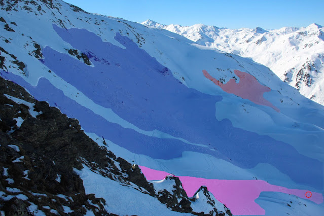
| Naturally triggered avalanche in eastern Verwall Massif (photo: 08.02.2022) |
 |
| A remotely triggered slab in Arztal, Tux Alps (photo: 05.02.2022) |
 |
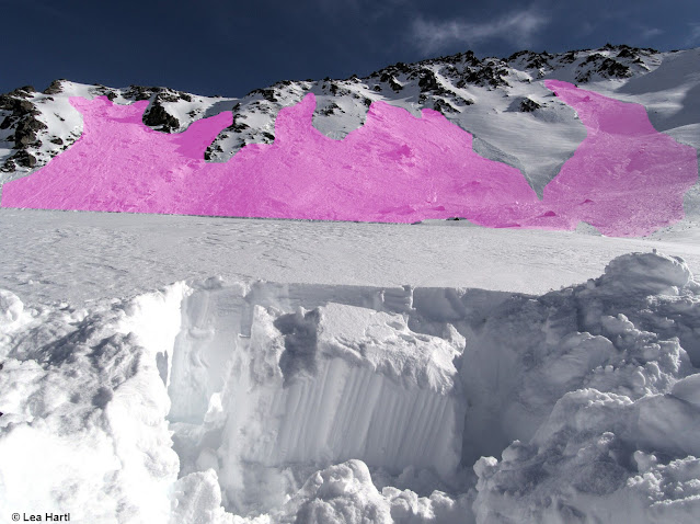
| Avalanches on Marchkopf: at far left, avalanche with entry track. At far right, depicted as thin line: the other slab avalanche from the same day presumably triggered by a skier. (photo: 10.02.2022) |
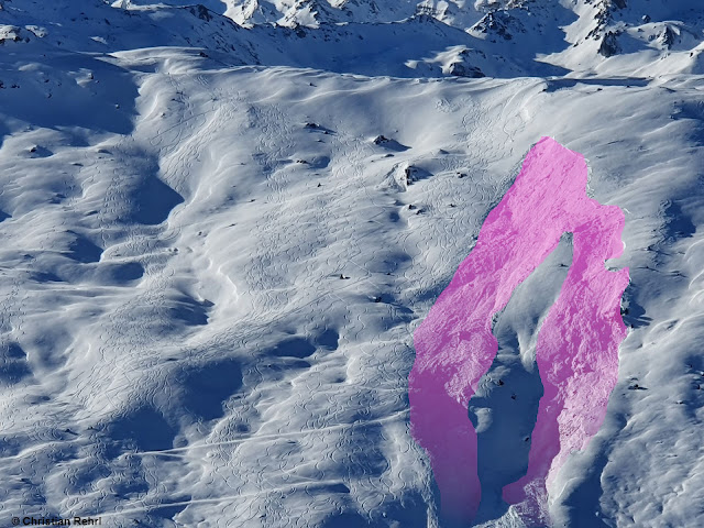 |
| Slab near Gilfert, eastern Tux Alps (photo: 06.02.2022) |
 |
| Expansive slab in eastern Lechtal Alps, near Namlos (photo: 10.02.2022) |
 |
| Slabs. At left, highly-frequented freeriding slope near See in Paznauntal (photo: 05.02.2022) |
 |
| Sulztal near Amberger Refuge: slab triggered during descent of a winter sports enthusiast. Head protruded from the avalanche, persons were able to rescue him uninjured. (photo: 09.02.2022) |
 |
| Settling noises and fracture cracks in northern Stubai Alps (photo: 08.02.2022) |
Nearly always, the weak layers lie at mid-level inside the snowpack
Analysis of the avalanches results almost invariably in the same picture: the crucial weak layer lies near the surface of the old snowpack which got blanketed on 31 January. It consists of faceted crystals beneath a thin melt-freeze crust which in some cases is sandwiched in by an additional crust.
 |
| At the glove: the weak layer, above it a thin crust, atop of that fresh snow and snowdrifts from 31.01.2022. Ötztal Alps (photo: 06.02.2022) |
 |
| Weak layer beneath thin melt-freeze crust. Profile from 05.02.2022; 2100m, West 31°, western Tux Alps (c) Alexander Blümel |
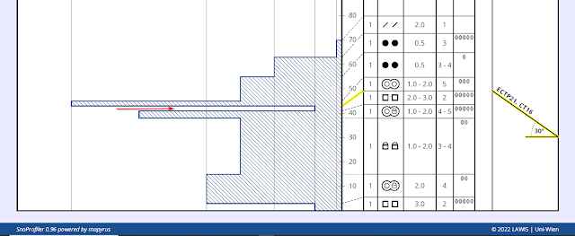 |
| ‘Crust sandwich’ in eastern Lechtal Alps. Profile from 10.02.2022; 1970m, North, 30°, (c) Markus Fleischmann |
Frequently observed: glide-snow avalanches
The last few days were quite warm, particularly at intermediate altitudes. The snowpack thereby became moist, where the snow was shallow often down to the ground. Glide-snow activities (avalanches and slides) were heightened correspondingly, at least at intermediate altitudes.
 |
| Glide-snow avalanche on 10.02. At left, a glide crack is visible. Eastern Tux Alps |
Weather review
Last week bore the stamp of pretty intensive precipitation on 6 and 7 February, along with quite stormy conditions on 7 February. At Innsbruck Airport, the absolute maximum wind velocity was measured.
 |
| Making history: never before were such windspeeds measured at Innsbruck Airport (115 km/h) |
 |
| Storm winds left a trail: broken branches of larch trees. Northern East Tirol (photo: 08.02.2022) |
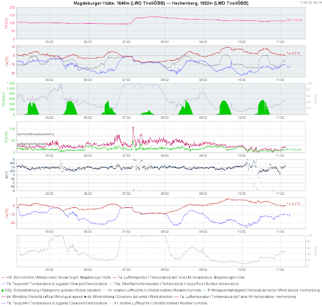 |
| Ugly weather with snowfall and storm winds on 06.02 and 07.02. Subsequently, a warm weekend. Snowpack became moist during the day. |
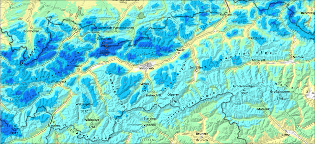 |
| Difference in snow depths from 06.02 to 07.02. |
Extraordinary: the number of avalanches reported between 03.02. and 06.02.2022
Never before were so many avalanches reported to Headquarters Tirol in such a short period as last week. Here an overview:
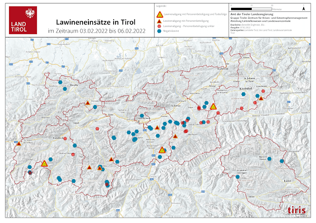 |
| 71 avalanches in 3 days, 3 with fatalities (8 dead). Most of the avalanches were so-called negative avalanches, i.e. reported releases in which no one was injured. |
Outlook for the weekend
A cold front moving in on 11.02 will bring some fresh snow to Tirol. Generally about 10 cm is anticipated, somewhat more in the northwestern regions. Subsequently, skies should rapidly clear again. Saturday and Sunday promise to be beautiful-weather days with slight southerly-foehn influence. The persistent weak layer threat remains unchanged!
 |
| We appeal to rational, intelligent backcountry tour planning and personal restraint. (photo: 09.02.2022) |
