Cold, loose powder constitutes an explosively reactive weak layer
To round out the last blog we want to call your attention to the fact that freshly generated snowdrift accumulations are, as a rule, prone to triggering. This is because of the weak layer consisting of loose, cold powder snow. In wind-protected terrain this is amazingly light, fluffy snow. It bonds extremely poorly with the snowdrifts deposited on top of it. For a brief spell, i.e. several days, the cold, loose powder snow is highly reactive, i.e. threateningly malicious, much like surface hoar which is blanketed by fresher snow. For that reason, one often sees glide cracks when one treads the snowdrifts, or hears settling noises. In isolated cases, even remote triggerings are possible. In addition, naturally triggered avalanches have been reported. This is generally a case of a small-sized slab, but near ridgeline terrain sometimes medium-sized releases.
Extremely varied zones: safe + unsafe lie cheek-by-jowl
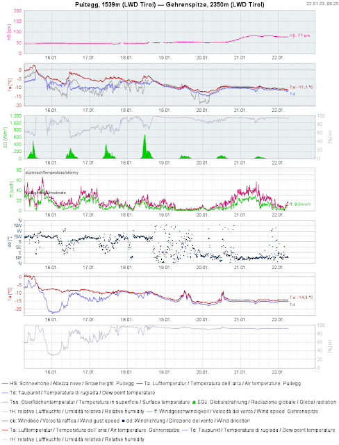
The snowpack is highly varied throughout the land. This applies both to the snowpack surface; to the snowpack layering; and to the distribution. It is the consequence of extremely diverse weather conditions this winter. Currently it is also a function of the highly fluctuating degree to which snow depths have grown and to wind impact.
 |
| 72-hr difference in snow depths |
 |
| Wind distribution on 22.01.2023, 5:00 am |
 |
| In some places, like here in Virgen in Osttirol, winds extended down to the valley floor. |
 |
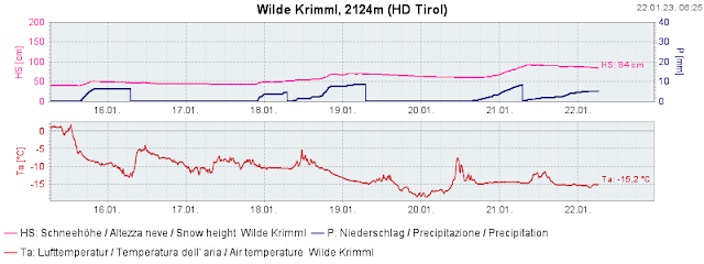
| Fascinating: the 15mm of precipitation during the last two days resulted in less than 50cm of fluffy fresh snow due to the low temperatures. Station Wilde Krimml in the western Kitzbühel Alps |
Freshly generated snowdrifts in steep terrain: AVOID THEM!
Hone your skills, sharpen your ability to recognize freshly generated snowdrifts on-site, and rigourously circumvent them in steep terrain. To an increasing degree, these avalanche prone locations are above the forested zones; however as we just pointed out, in some places the wind extended down to low lying areas. Danger zones can also lie in steep forest clearances at far lower altitude, for example.
.jpg) |
| Wind impact at the edge of a forest. Hahnenkamm near Reutte (photo: 21.01.2023) |
.jpg) |
| High proneness to triggering wherever cold, loose powder snow has been covered by snowdrifts. Bergeralm, central Stubai Alps (photo: 21.01.2023) |
.jpg) |
| Wind influence even in low lying areas like here inside town limits of Matrei in Osttirol (photo: 21.01.2023) |
Persistent weak layer persists
To round out the last Blog: the snowdrift masses which accumulated due to heavy wind can constitute a slab in zones where the snowpack previously was loose / low in tension. Increasingly this was in shady terrain starting at about 2000-2200m. Also in sunny terrain, whenever a new slab forms, the likelihood of faceted layers bordering crusts triggering is heightened. This occurs particularly at altitudes starting at 2300-2500m.
Yes, superb powder descents are also possible!
Safe and Unsafe often lie right next to each other. What matters here is experience in assessing avalanche dangers on-site. That’s how to distinguish safe from unsafe zones. Then, fabulous powder descents are on the agenda.
.jpg) |
| Swishing in the western Kitzbühel Alps (photo: 21.01.2023) |
