Fresh snowdrift masses generally small, but very prone to triggering
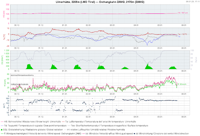
Strong westerly winds are currently raging at high altitudes. They are transporting the few centimetres of fresh snow that fell on 3 January and 5 January. The fresh fallen snow is generating (particularly in wind-protected shady terrain) a potential weak layer for the fresh snowdrift accumulations deposited on top of it. Inside the fresh snow there is also graupel and small surface crystals. Snowdrifted masses are currently rather small, thus, the avalanches also small (medium-sized near ridgelines).
.jpg) |
| This slide on a north-facing Zuckerhütl slope in the Stubai Alps is a 15 cm fracture. It is a fresh snowdrift. (photo: 04.01.2022) |
 |
| Some fresh fallen snow in the mountains. Below 2000 m there was rainfall. |
 |
| Quite strong winds were blowing at high altitudes. |
 |
| Last week it was MUCH TOO WARM (record-breaking since the beginning of measurements). Hardly any precipitation. Strong winds currently. |
Persistent weak layer over small areas, particularly on shady slopes
No reports of avalanche releases involving persons were received last week, confirming our estimate: an old snowpack with few inner tensions, corroborating most of the stability tests which have been conducted. (In outlying terrain, one often breaks all the way down to the ground.) Nevertheless, the persistent weak layer remains treacherous. A few avalanche prone locations occur in very steep terrain where there are deep older snowdrift masses. Increasingly this occurs in shady ridgeline terrain. Caution urged in transitions from shallow to deep snow.
.jpg) |
| Fractures in the old snow cannot be ruled out, but will probably be more seldom. Tux Alps (photo: 30.12.2022) |
Springtime conditions at the height of winter
It is much too warm for this juncture of the season. This has brought about a further melting of the small amount of snow on the ground, particularly on sunny slopes. Also, rather good firn-snow conditions were quite out of the ordinary. Increasingly frequent reports about this arrived from southern East Tirol.
.jpg) |
| Wet loose-snow and glide-snow avalanches in sunny terrain. Southern East Tirol (photo: 01.01.2023) |
.jpg) |
| The higher temperatures even activated plant growth. South. 1300 m. Near Lienz (photo: 05.01.2023) |
.jpg) |
| The best touring conditions, comparatively, are currently in southern East Tirol. (photo: 04.01.2023) |
A quick glimpse into the snowpack
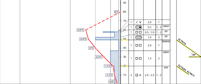
Below, two snow profiles which are quite typical of the current situation.
Ski runs often possible only on artificial snow
Without artificial snow a ski area would frequently not be in operation, or only on very reduced basis. Some ski areas benefited from the cold days around 10 December.
.jpg) |
| Snow ribbons down to the valley. Zillertal (photo: 04.01.2023) |
.jpg) |
| Snow piles, as a reserve. Zillertal Arena (photo: 04.01.2023) |
.jpg) |
| Similar picture in Ausserfern. Hahnenkamm region (photo: 01.01.2023) |
Attention: numerous serious skiing accidents very near ski runs
Since the Christmas holidays, serious - including fatal - skiing accidents due to hardened ski runs and a lack of space for falls outside the runs have been frequent. The Austrian Commission for Alpine Safety has written a press release on the subject. Details can be seen here:
What’s on the horizon?
According to the weather service (formerly known as ZAMG, rechristened as Geosphere Austria) there are no great snowfalls in view. The weather is expected to be variable. This applies both to the temperature and the wind development. Initially it will be far too warm. Tomorrow, Epiphany, should be quite sunny, after the fogbanks disperse. Thereafter, foehn conditions are expected to increase. Starting on Monday, precipitation and dropping temperatures are foreseen.
Avalanche danger levels are not expected to change significantly to start with. Freshly generated snowdrift masses should be avoided in very steep terrain. Pay special attention to the risks of being swept along in extremely steep terrain.
.jpg) |
| Snow transport at high altitudes will be a constant theme over the coming week. (photo: 05.01.2023) |

