Main problem: fresh snowdrifts
Finally we have reached temperatures which are appropriate to the season. Currently we lie at the long-term mid-level of air temperature measurements for this juncture. Thus, the fresh fallen snow of recent days is frequently loose wherever there was no wind. And where wind was blowing, the fresh snow was swiftly transported. Freshly generated snowdrift accumulations are frequent, lying atop cold, loose fresh snow, a quite malicious (prone to triggering) weak layer which has existed in that state for only a few days. For that reason, winter sports enthusiasts can easily trigger avalanches; these are generally small but with ascending altitude increasingly medium-sized. Caution is urged most of all near ridgelines, behind abrupt discontinuities in the terrain and in steep gullies and bowls. Where winds are strong, even naturally triggered avalanches are conceivable. Currently, this applies to the eastern regions in particular.
.jpg) |
| Breathtaking snow plumes could be observed especially along the Main Alpine Ridge and in the typical foehn lanes at the beginning of the week. Stubai Glacier (photo: 16.01.2023) |
.jpg) |
| Winds in the foehn lanes were conspicuous also below the treeline. Western Tux Alps (photo: 16.01.2023) |
.jpg) |
| Fresh, trigger-sensitive snowdrifts in the Kalkkögeln (photo: 16.01.2023) |
.jpg) |
| Glide cracks in the snowpack can signal a potential snowdrift problem. Geigenkamm ( photo: 16.01.2023) |
 |
| Starting on Sunday, 15 January, it turned colder. Winds from varying directions were blowing, predominantly at strong velocity. |
Avalanches last week
On 12.01.2023, remote triggerings (one small and one medium-sized slab avalanche) were reported in the Samnaun Massif in the west. On the weekend (14-15 January) additional avalanches released which were provoked by a persistent weak layer. This occurred at altitudes above about 2200m in all aspects (for details see
lawis.at). In the last few days it was the freshly generated snowdrifts which got triggered by winter sports enthusiasts. In isolated cases there were glide-snow slides on grass-covered slopes, particularly during and after the rain impact of 14 and 15 January.
_bearbeitet.jpg) |
| Remote triggering in Samnaun Massif, 2750m, W (photo: 12.01.2023) |
_bearbeitet.jpg) |
| A slab avalanche that triggered near the ridgeline when skiers entered the slope. Greitspitze, Samnaun Massif along the Tirolean/Swiss border. 2700m, SE. Persistent weak layer (photo: 14.01.2023) |
_bearbeitet.jpg) |
| Slab avalanche in Rettenbachtal due to persistent weak layer. SE. 2200m (photo: 14.01.2023) |
_bearbeitet.jpg) |
Slab avalanche near ridgeline when skiers entered the extremely steep east-facing slope at 2800m.
Persistent weak layer (photo: 14.01.2023) |
.jpg) |
| Glide-snow slides in Ausserfern (photo: 14.01.2023) |
The snowpack
There wasn’t really much fresh snow that fell this week. Mostly it amounted to 10-20 cm, more from place to place in the eastern regions. Frequently there was graupel embedded in the fresh snow. Along with the near-surface problem zones already mentioned (loose fresh snow as weak layer for the fresh snowdrifts deposited on top of it), there are also additional potential weak layers deeper down in the old snowpack. Generally these are faceted crystals near thin crusts or depth hoar/faceted crystals at ground level. In stability tests, partial fractures occurred in most results. Sometimes the entire snow cover was structured loosely; or else there was a slab. Nonetheless, there still exist zones which are prone to triggering, increasingly in terrain which has not yet been tracked. These are mostly shady slopes above 2200m and sunny slopes above 2500m. Transitions from shallow to deep snow are considered zones where there is heightened likelihood of triggering. The steeper the slope, the higher the chances a slab avalanche will trigger in the old snow.
.jpg) |
| A frequent guest during recent rounds of snowfall: graupel. Venediger Massif (photo: 18.01.2023) |
 |
Snow profile in Glockturm Massif: N, 2480m, 26° from 19.01.2023.
Quite typical: weak base, but still only partial fracture. |
 |
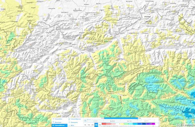
| 48-hr snow depth difference from 17.01.2023 |
 |
| 48-hr snow depth difference from 19.01.2023 |
 |
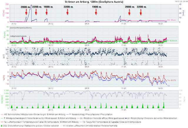
| Quite unusual this winter: frequent rainfall up to high altitudes, e.g. here in the Arlberg region. |
 |
| We continue to see below-average snow depths at all measurement stations (upper graph). Middle graph: measured fresh snow. Lower graph: this years’s temperature fluctuations and difference from medium values. |
.jpg) |
| Heightened risk of falling into a crevice continues on the glaciers. Venediger Massif (photo: 12.01.2023) |
Outlook
According to Geosphere Austria (formerly ZAMG), cloudy, windy, cold days lie ahead of us. The predominant snowdrift problem will persist. Caution: loose powder snow which has been blanketed by freshly generated snowdrift accumulations is still especially prone to triggering. For that reason, rigourously circumvent fresh snowdrift accumulations in steep terrain.
.jpg) |
Rough-hewn picture of coming weather conditions... Western Karwendel (photo: 19.01.2023)
|
.jpg)
.jpg)
.jpg)
.jpg)

_bearbeitet.jpg)
_bearbeitet.jpg)
_bearbeitet.jpg)
_bearbeitet.jpg)
.jpg)
.jpg)


.jpg)
.jpg)
