Highly variable conditions
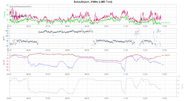
The best way to describe the current weather, snow and avalanche situation is with the phrase “highly variable.” Last week was marked by a sequence of warm and cold fronts, repeated snowfall, most of it in the western regions and in northern East Tirol, maximum 50-75 cm, but generally 30-50 cm. Strong to storm-strength winds were always blowing, initially from the south, then from the west.
The strong-velocity winds transported masses of snow at high altitudes, and that is precisely how the terrain now looks: windblown zones alternate with wind-loaded zones (gullies and bowls). The overall impression that there is simply too little snow for this juncture of the season is not illusory.
Highly variable: the snowpack
Highly variable: the snowpack
.jpg) |
| Heavily wind-impacted snow cover in the eastern Lechtal Alps (photo: 12.01.2023) |
.jpg) |
| Storm above the timberline. Venediger Massif (photo: 10.01.2023) |
.jpg) |
| In the Kitzbüheler Alps (photo: 11.01.2023) |
.jpg) |
| Cornices forming on the ridgeline. Samnaun Massif (photo: 10.01.2023) |
Highly variable: the weather
 |
| 72-hr snow depth change on 09.01 and 12.01.2023 |
 |
| In the high mountains, strong to storm-strength winds from varying directions were blowing. |
Highly variable: the snowpack
The results of stability analysis: a snowpack of medium stability tended to dominate. But reports of settling noises and glide cracks, particularly at altitudes of 2000-2400 m, have become more frequent over the last few days. The weak layer was usually a thin, loose, generally faceted layer above or below thin surface-near melt-freeze crusts. Atop of that lay the fresh snow and snowdrifts of recent days. Elsewhere there were loose layers near ground level. These were found most of all in wind-protected bowls over widespread terrain, and were quite cohesive. Graupel was often discovered inside the layers of fresh snow and snowdrifts.
.jpg) |
| Profile near Löchelspitze in the Allgau Alps: the recent round of fresh snow is visible, beneath that a sequence of crusts, harder and softer layers. (photo: 11.01.2023) |
.jpg) |
| The snowpack surface is wildly irregular. Samnaun Massif (photo: 10.01.2023) |
Highly variable: avalanche activity
Over the course of this last week, a number of avalanches were observed: loose-snow, glide-snow and slab avalanches. All in all, there were not so very many. The loose-snow and glide-snow avalanches released mostly after the snowfall on 9-10 January when weather conditions improved and temperatures rose. Slab avalanches were mostly medium-sized. One interesting release was reported from the Saumspitze in the Arlberg region, where a large-sized slab avalanche triggered naturally in early afternoon on 6 January in shady high alpine terrain. On the previous day, lots of snowdrifts were deposited there as a result of the strong westerly winds. At the time of the avalanche the wind had slackened off significantly, but the temperature had risen.
_bearbeitet.jpg) |
| Large-sized naturally triggered slab avalanche below the Saumspitze (photo: 06.01.2023) |
In an avalanche release near the Stubai Wildspitze on 10 January, 5 persons were buried by a slab avalanche. Two persons were injured, one person suffered from hypothermia. The investigations of the Alpine Police showed that at the time of the accident 19 persons were in the zone of a large wind-hole digging snow-spots for protection. The slab avalanche triggered at a width of about 30 metres and a length of about 10 metres. Thanks to a swift rescue operation, the worst was avoided.
_bearbeitet_2.png) |
| Slab avalanche Stubai Wildspitze at about 3150 m. The circles roughly depict the zones where the snow-spots were dug. (photo: 11.01.2023) |
Our own on-site snowpack analysis produced an interesting picture: while the recent snowfall was being deposited, inside the masses of fresh snow and snowdrifts were repeated packages of graupel. We found up to 3 different layers of graupel on-site. With a high degree of probability, these layers of graupel were the likely cause of the avalanche. The bowl-like terrain favoured the deposit of thick graupel layers due to the sliding of these grains from extremely steep into flatter areas. The report of one observer on-site was also interesting. In the entire area there were 25 artificial triggerings through explosives but with very little success.
 |
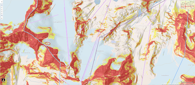
| The tiny ellipse at left shows the point of the accident from an overview (c) tiris |
Highly variable: that’s how it will continue...
Just the way this last week wrapped up, that’s the way the next week will unfold: highly variable.
.jpg)

.jpg)
