Danger zones hard to spot, even for experts
Avalanche danger in the western regions of North Tirol and in northern East Tirol above 2200m and above 2400m continues to be considerable. The underlying problem is the persistent weak layer. That means we are confronted with weak layers in the old snowpack which remain prone to triggering for an extended period of time. Specifically, we are seeing faceted crystals and depth hoar in layers near the ground. These layers often border up against thin crusts. Danger zones are found increasingly on W/N/E facing slopes above 2200m / 2400m and on south-facing slopes above about 2800m.
Typical of the current situation is the highly varied nature of snow depths, but also snow quality: transitions from deep to shallow snow fluctuate just as zones with good and poor snowpack stability. Yet it is also typical of the current situation that the danger zones are really hard to recognize, even for professionals. That means, experience in assessing avalanche danger, together with immense restraint in outlying terrain, are crucial factors when you are en route.
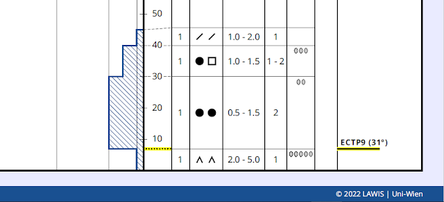 |
Weak layer of depth hoar near the ground which can easily be disturbed. Profile from 26.12.2022
(for further details, see lawis.at) |
 |
| Snow profile northern Zillertal Alps. 2250m. North. 32°. In stability tests here, no fracture could be generated. Profile from 28.12.2022 (for further details, see lawis.at) |
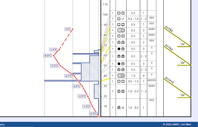 |
| Snow profile Sellrain Mountains. 2520m. NE. 25°. Fracture of snowpack near the ground in a faceted layer just beneath a thin melt-freeze crust. (for details, see lawis.at) |
.jpg) |
| Becoming rare: remote triggerings of slab avalanches, like here in Kleines Königtal in the Gurgl Massif on 28.12.2022. |
.jpg) |
| Danger zones are still found in the immediate vicinity of ski runs. Samnaun Massif. (photo: 29.12.2022) |
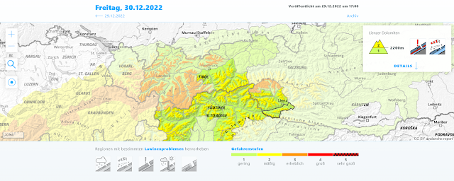 |
| More favorable: conditions in the southern regions of North Tirol (apart from northern East Tirol). The problem here is the lack of snow. |
Snow depths: (way) below average for the time of year
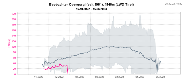
Some of our observation stations have been in operation since the Avalanche Warning Service Tirol was established in 1960. We extend an enormous vote of thanks to our observers over many years. If you look at the current snow depths there, we have descended below the minimum ever recorded.
 |
| Observation station Obergurgl: maximum, medium, minimum overall snow depth until now. Magenta line is the season 2022-23. Never before since measurements have been recorded has there been so little snow on the ground. |
 |
| Observation station Obertilliach: also here, overall snow depth for the season is below average. |
.jpg) |
| Not much snow in open terrain. During a descent heightened risk of injury from rocks sticking out of the snow (or just barely concealed). Grieskogel Massif. (photo: 28.12.2022) |
.jpg) |
| The thaw around Christmas included rain and had an awful impact on the snowpack in most regions of Tirol. Mieming Massif (photo: 25.12.2022) |
 |
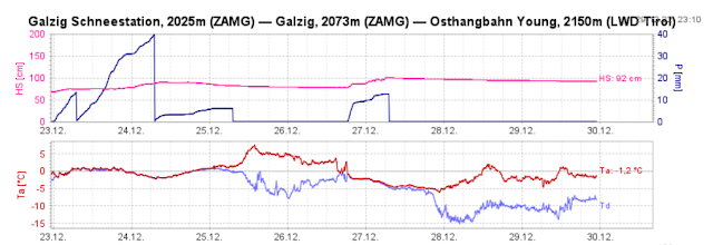
| Last week’s weather in western regions: initially lots of precipitation including rainfall (up to 2300m). Minor cold front on 26-27.12. Then dry weather (for this juncture of the season) and above average temperatures. |
.jpg) |
| Low and intermediate altitudes are frequently bare of snow. View towards Kaunergrat. (photo: 29.12.2022) |
What’s next? Very high temperatures!
The ZAMG Weather Service predicts unusually high temperatures for the next few days. Thus, the year 2022 will end (and go down in history) as the warmest year in the history of measurements, which goes back more than 250 years. Last year also broke some temperature records. This year might break them again. Since there is hardly any snow on the ground at low and intermediate altitudes, the high temperatures will probably not have grave effects on avalanche danger levels. However, we expect increasingly frequent glide-snow and possibly wet-snow slides on sunny slopes and grass-covered terrain. Outside of that, the persistent weak layer will incrementally diminish, unless it becomes so warm and the air so moist that water penetrates down to the ground level layers and leads to heightened proneness to trigger. That is unpredictable at the moment, it simply remains a possible implication.
.jpg) |
| As a result of higher temperatures, glide-snow activity will increase again. (photo: 29.12.2022) |
The entire team at Avalanche Warning Service Tirol wishes everyone good health and no accidents in the year 2023!


.jpg)
.jpg)


.jpg)
.jpg)
.jpg)
.jpg)
