Significant increase in avalanche danger
Warm front and cold front
A warm front will bring instabile, stormy and very mild mountain weather our way on Friday, 23.12.2022, according to ZAMG Weather Service Innsbruck. In places there will be intensive precipitation, in many places below about 2000 m as rain. Precipitation will be most intensive in the western part of North Tirol: 30-50 mm is expected there on 23.12. This correspondes to about 30-50 cm of fresh snow. On Christmas Eve, 24.12, a cold front will follow on its heels. In the morning, frequent snowfall and rainfall in North Tirol and in the northern regions of East Tirol. In the afternoon it will slacken off. Southern East Tirol will get hardly any precipitation.
 |
| Forecast fresh snow over the next few days. Precipitation gradient from west to southeast. |
 |
| Precipitation will frequently be accompanied by strong to storm-strength winds. |
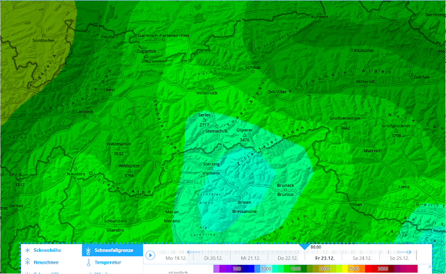 |
| Snowfall level at midnight, 23 December |
 |
| Snowfall level will ascend during the course of the day. Above: snowfall level at 4:00 pm on 23.12.2022 |
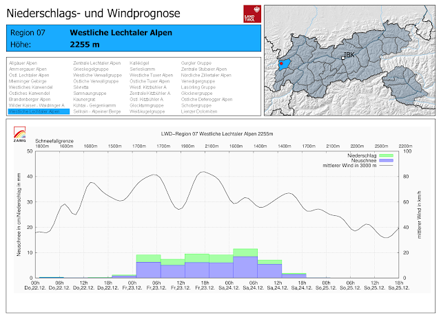 |
| Precipitation and wind forecast for one region where it will be heaviest. Precipitation will begin during the night of 22.12 and persist until Christmas Eve. Strong winds. Fluctuating temperatures. |
Impact on avalanche danger
Currently we expect a significant increase in avalanche danger during the course of the day. If the forecast amounts of precipitation occur, Danger Level 4 (high) will be reached in the afternoon / early evening. This is a so-called “winter-sports high” – the snowpack is weak and prone to triggering; there are numerous danger zones; the likelihood is great that winter sports enthusiasts can trigger slab avalanches. In addition, we expect naturally triggered avalanches. Most will be medium-sized (typical magnitude of skier’s avalanche). Especially on shady slopes, these can grow to large size. Here are the reasons:
- Wherever it snows, the snow will initially fall at lower temperatures. During the snowfall temperatures will rise. Thereby, warm snowfall will be deposited atop colder snowfall, i.e. a “slab” on a potentially weak layer. Depending on how much the temperature rises, the snowpack will be weakened with varying swiftness. Small-to-medium avalanches will release naturally, more and more as the temperature rises. The “slab” will release ever larger masses of snow. That slab also heightens the likelihood of remote triggerings.
- The old snowpack is weak in many places. This is increasingly the case on west-facing, north-facing and east-facing slopes above 2200 m. Fractures in the weak layers inside the old snowpack are possible from the impulse of naturally triggered superficial avalanches in the fresh fallen snow. On the other hand, this is possible “only” through the weight of fresh fallen snow. The old snowpack on north-facing slopes above 2200m is least favourable of all. On west-facing and east-facing slopes the old snowpack is triggerable above about 2400m. On south-facing slopes, this is the case mostly in high alpine terrain. If fractures occur in the old snowpack, the avalanches can grow to large size.
- In zones with rain impact the snowpack is moist or thoroughly wet already and will become wetter still. The snowpack will forfeit its firmness. We expect numerous wet loose-snow avalanches but also increasingly frequent glide-snow releases. Due to the shallow snowpack, most of these will be small sized, in isolated cases medium sized.
Impressions of the current situation
.jpg) |
| Cracks in the snowpack: the alarm signal for a trigger-sensitive snowpack. Sattelberg, 14.12.2022. The photo is more than a week old. In the meantime we have received few reports of glide cracks and whumpf noises. |
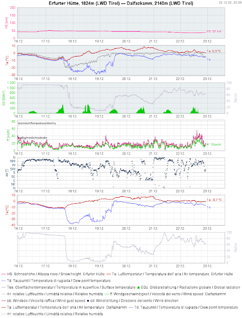 |
| At low and intermediate altitudes the snowpack is moist. (2nd graph above with temperature, thawing point and snow-surface temperature). The winds have intensified. |
 |
| Due to higher temperatures and recent rainfall, increasingly frequent wet loose-snow avalanches and glide-snow slides have been observed. |
.jpg) |
| Wet snowslide, north side of Kitzbühler Horn (photo: 20.12.2022) |
%20.jpg) |
| Knobby powder snow - now gone, due to the rise in temperatures, Tux Alps (photo: 18.12.2022) |
 |
| Profile near Hochzeiger, north, 2340 m. Weak layer near the ground which can fracture upon loading. |
.jpg) |
| Sequence of hard and soft layers. Axamer Lizum, west, 2260 m, 28°. At this spot no thorough fractures were generated in our stability tests. (photo: 22.12.2022) |
.jpg) |
| Winds have already intensified and transported snow at high altitudes. Above, snow plumes in the Gurgl Massif. (photo: 22.12.2022) |
Treacherous and accident-prone days lie ahead for winter sports enthusiasts. Immense restraint is called for.
On Sunday, Christmas Day, 25.12, the weather will improve. It will remain mild. Please heed this warning: in the regions where the most snowfall occurs we will have a very tense avalanche situation. That is - as we all know - when most of the avalanche accidents occur, in that brief time window. Therefore, act defensively. The inexperienced are advised to remain on the secured ski runs.


.jpg)
%20.jpg)

.jpg)
.jpg)
.jpg)