Wednesday, 28 December 2022

Good explosion triggerings and triggerings by persons confirm: snowpack still weak

Treacherous avalanche situation continues


Right off the bat: particularly in the western regions, but also in northern East Tirol, we have a tenacious problem with a persistent weak layer which is quite pronounced. This problem begins at about 2200m (generally at 2400m), to start with on shady slopes, later frequently on west-facing and east-facing slopes. Above about 2700m it is found increasingly on south-facing slopes.

This is confirmed by stability tests, also by slab avalanches which have been triggered by winter sports enthusiasts and in some regions by successful artificial triggerings through explosives over the last few days. The artificial triggerings were reported to us from the western regions where snowfall was heaviest.

Slab avalanches were triggered due to the well formed “slab” (snowfall, warmth, wind) which was quite extensive in places and occurs repeatedly in seasons when the snow depths are below average.

The situation is treacherous also because the avalanche prone locations in outlying terrain are difficult to recognize and distributed in highly irregular fashion. In addition, we observe high variations not only in snow depths, but also in snowpack stability.


A brief review of the last few days:
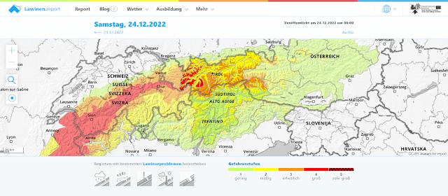

Vom 23.12. abends bis inkl. 25.12.2022 stuften wir die Lawinengefahr im Westen des Landes in der Höhe mit "groß", also Stufe 4 ein. Es handelte sich dabei um ein "Wintersportler-Groß"
From the evening of 23.12 through 25.12.2022 in western regions, the Danger Level was “high” - level 4. This was the “winter sports high” we wrote about.


Wetterstation Dias/Kappl im neuschneereichen Westen des Landes. In der Höhe ca. 50cm Neuschnee. Erwärmung während des Schneefalls. Am 25.12. Schönwetter, dann kleine Kaltfront mit Wind und folgender Wetterbesserung.
Dias/Kappl weather station in the west where snowfall was heaviest. About 50cm of fresh snow at high altitudes. Rising temperatures during the snowfall. On 25.12 fine weather, then a small cold front with winds, subsequently improved weather.


In tiefen und mittleren Lagen schmolz der Schnee durch Regen dahin. Die Regengrenze lag meist um 2300m. Oberhalb etwa 2200m-2400m schneite es v.a. im Westen des Landes 30-50cm, lokal auch mehr.
At low and intermediate altitudes  rainfall melted the snow. Rainfall level was  mostly around 2300m. Above 2200-2400m 30-50cm of fresh snow was registered, mostly in western regions, more from place to place.


A few avalanches triggered by winter sports enthusiasts


We were lucky in Tirol that over the Christmas holidays no one suffered injuries from avalanches. We are aware of several avalanche releases which involved winter sports enthusiasts. Here a brief selection:


Lawinenabgang Lampsenspitze vom 25.12.2022. NO. 2700m. Person konnte ausfahren. (Foto: 25.12.2022)
Avalanche release Lampsenspitze on 25.12.2022. NE, 2700m. The person could evade it.
(photo: 25.12.2022)


Weiterer Lawinenabgang Lampsenspitze vom 26.12.2022. Ost, 2840m. Keine Verschütteten. (Foto: 26.12.2022)
Another avalanche on the Lampsenspitze on 26.12.2022. East, 2840m. No one caught. (photo: 26.12.2022


Lukas Ruetz, einer unserer Beobachter, recherchierte aufgrund von Webkameras (großflächige) Lawinenabgänge im Bereich des Pirchkogels und des Hinteren Grieskogels. Rote Ellipse: Spontaner Lawinenabgang um 10:40 Uhr. Türkise Ellipse: Spontaner Lawinenabgang um 11:10 Uhr. Grüne Ellipse: Lawinenauslösung durch Wintersportler um 13:00 Uhr. 2600m Nord und Ost
Lukas Ruetz, one of our observers, researched avalanche releases with large-scale lens web cameras near the Pirchkogel and Hinteren Grieskogel. Red ellipse: naturally triggered avalanche at 10:40 am. Turquoise ellipse: naturally triggered avalanche at 11:10 am. Green ellipse: avalanche released by winter sports enthusiasts at 1:00 pm. 2600m, N and E.


Foto vom Anriss Pirchkogel / Ht. Grieskogel auf 2660 Nord. Eingekreist: Aufstiegs- und Abfahrtsspur eines Wintersportlers. Vieles spricht dafür, dass die Lawine durch eine Person im Aufstieg im Bereich des Kreises fernausgelöst wurde. (Foto: 26.12.2022)
Photo of Pirchkogel fracture / Hr. Grieskogel at 2660 N. Encircled: ascent and descent track of a winter sports enthusiast. All evidence points to the avalanche having been remotely triggered by the person in the area of the circle. (photo: 26.12.2022)


Underlying this theory regarding the above avalanche is the significantly rising temperature during the day, which had an impact on the characteristics of the “slab.”
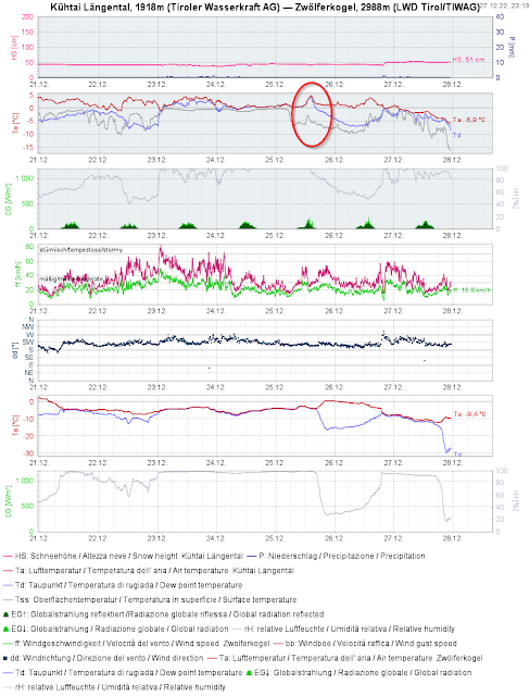

Eingekreist: Temperatursprung am 25.12.2022. Station Kühtai im Nahbereich des Lawinenabgangs
Encircled: temperature leap on 25.12.2022. Kühtai weather station in the vicinity of avalanche.
 

Im unmittelbaren Nahbereich der Pirchkogellawine löste sich eine Schneebrettlawine als sich ein Wintersportler im Bereich der Ellipse bei der Abfahrt befand (Foto: 26.12.2022)
In the immediate vicinity of the Pirchkogel avalanche, a slab avalanche was triggered as a winter sports enthusiast was descending near the encircled area. 2595m NE (photo: 26.12.2022)


Ein Lawinenabgang am Tiefenbachferner. 2830m, NO. Einfahrender Skifahrer konnte ausfahren, meldete dies aber nicht bei der Leitstelle Tirol unter 140. Erst nach einer großangelegten Suchaktion konnte der Einsatz abgebrochen werden. (Foto: 25.12.2022)
An avalanche release on Tiefenbachferner glacier. 2830m, NE. The skier was able to ski out of the plummet path but did not report it to headquarters (tel. no. 140). Only after a big rescue operation was the emergency search terminated. (photo: 25.12.2022)


Lawinenabgang Rietzer Grießkogel vom 27.12.2022. Lawine wurde im Aufstieg fernausgelöst. Person wurde teilverschüttet. 2700m. SW
Avalanche release Rietzer Griesskogel on 27.12.2022. Avalanche was remotely triggered during the ascent. A person was partially buried. 2700m, SW


Lawinenauslösung Weißer Knoten in der Glocknergruppe vom 27.12.2022. Der Bruch breitete sich orographisch links noch weiter aus. ca. 2600m, Ost
Avalanche release Weisser Knoten in the Glockner Massif on 27.12.2022. The fracture expanded orographically left. Appx. 2600m, E


Lawineneinsatz aufgrund einer "Kunstschnee"-Gleitschneelawine im Bereich der Untermarkter Alm in Hochimst (Foto: 27.12.2022). Der Einsatz wurde in den Abendstunden abgebrochen, nachdem mit sehr hoher Wahrscheinlichkeit davon ausgegangen werden konnte, dass keine Personen verschüttet waren. (Übrigens löste sich am 05.12.2018 an derselben Stelle eine ebensolche "Kunstschnee"-Gleitschneelawine.)
Avalanche operation due to a glide-snow avalanche of artificial snow near Untermarkter Alm in Hochimst (photo: 27.12.2022). The operation was terminated in the evening after all signs pointed to no one having been buried. (Incidentally, on 05.12.2018 on the very same spot, another such glide-snow avalanche of artificial snow was triggered.) 


Am Karnischen Kamm: Gleitschneerutsche auf steilen Wiesenhängen. (Foto: 26.12.2022)
On Carnic Ridge: glide-snow slide on steep grass-covered slopes. (photo: 26.12.2022)


Der Wind wehte kürzlich in der Höhe sehr stark. Hier ein Bild von Schneeverfrachtungen in der Gurgler Gruppe (Foto: 26.12.2022)
Winds were briefly blowing at very strong velocity at high altitudes. Above, snow transport in the Gurgl Massif. (photo: 26.12.2022)


Outlook

The regionally quite treacherous avalanche situation will continue. The recently formed “slab” is still quite pronounced, thus, virtually demanding expansion of a release upon fracture in the weak layer of the snowpack. For that reason we recommend level-headed restraint in outlying terrain. Besides, due to the poor snow situation, conditions for skiing and freeriding tours are  rather bad in general.