Main danger remains fresh snowdrifts
Right off the bat: the overall situation is favorable. Caution is urged towards freshly generated snowdrift accumulations. They are likeliest to trigger in very steep terrain, often near ridgelines or behind protruberances. Weak layer: blanketed champagne powder, also faceted crystals over small areas in the vicinity of surface-near melt-freeze crusts. Most of the time these are small-sized avalanches, thus, the risks of taking a fall outweigh those of being buried in snow.
 |
| Small, partly blanketed slab avalanche - Glockturm Massif. photo: (13.01.2022) |
Thus, the snowpack is without much tension. Surfaces often show striking effects of wind. The embedded crusts are omnipresent. And just as omnipresent is an expansively metamorphosed (faceted) ground-level snowpack at high and high-alpine altitudes. Snow quality worsened during the week. Powder which is a joy to ski through is becoming a rarity....
 |
| Wind was a frequent companion in backcountry last week. Stubai Glacier (photo: 11.01.2022) |
 |
| Wind impact is amply evident. Deferegger mountains (photo: 08.01.2022) |
 |
| Wherever the snowpack surface is ‘knobbed’ sking is still a pleasure. Glockturm Massif (photo: 13.01.2022) |
Below average snow depths
A glance at the long-term records of our most ardent observers makes it clear: currently in most parts of the land, snow depths are below average.
 |
| Graphs of observer Klaus Friedl from Boden, Lechtal: the upper graph shows measured maximum and minimum snow depths since 1960. In addition, also mean values and, in magenta, current overall snow depths are depicted. These lie below the 61-year mean value. The second graph shows the fresh snow measured until now. The lower graph depicts temperatures, where the maximum temperature at the beginning of January can be seen. |
The effects in outlying terrain are visible when you are out in backcountry. Making abrupt (forced) acquaintance with stones occurs far more often.
 |
| Backcountry in the northern Stubai Alps (photo: 09.01.2022) |
 |
| The “sharks” freeriders are so terrified of: just barely covered stones which drastically raise the danger of falls and injuries during descents. (photo: 13.01.2022) |
On the lookout for dp.4 (danger pattern: cold on warm)
We are currently following most tenaciously the possible development of faceted crystals near the rain crust which developed during the warm front on 29-30 December. In some snow profiles we have seen signs of this.
We have had only two reports of such an awful development, i.e. a possible fracture propagation. This was at 2700 m in very steep, sunny terrain, but was small. Due to the weather forecast (lots of sunshine, mild temperatures) we assume that dp.4 will strike only very small problem zones on wind-loaded very steep slopes in a limited band of altitude and aspect.
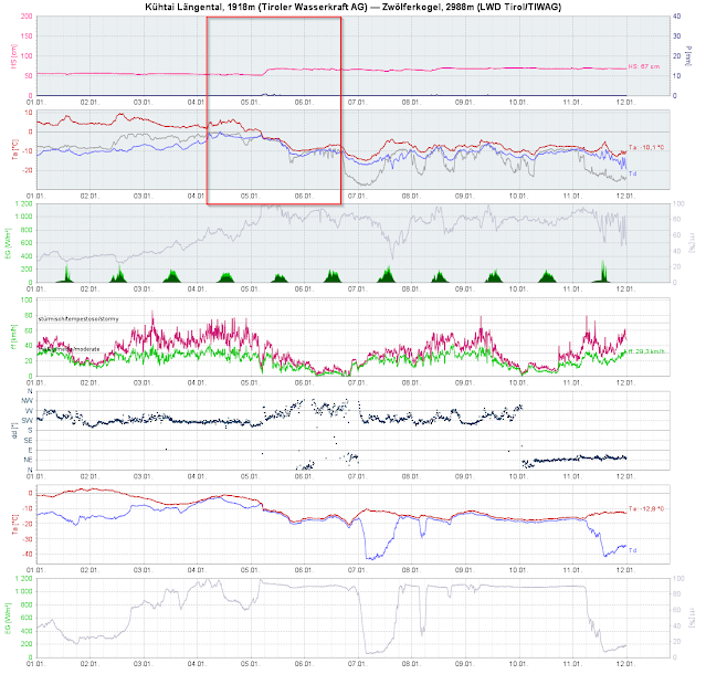 |
| Weather-station graphs from 1 January: above average temperatures initially. The snowpack surface became moist. Then on 5 January, snowfall and plummeting temperatures: ideal conditions for danger pattern 4 to develop. Also visible: lots of wind. |
 |
| To be prepared for the next round of snowfall (which we will have to wait for) we always follow the developmenet of the snowpack. Currently our focus is on the expansive metamorphosis near crusts. Ausserfern (photo: 11.01.2022) |
 |
| The arrow points to a layer of faceted crystals above the rain crust from the end of December, generated due to dp.4: western Kitzbühel Alps. 1660m, North, 20°. |
In order to make the picture of this development sharper, we are grateful for your observations in outlying terrain. Please send your mails to: lawine@tirol.gv.at or snow profiles and stability tests to www.lawis.at. Thank you!