Fresh snowdrift accumulations: assess them critically!
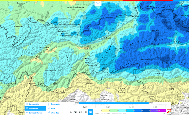
Following a long phase of favorable avalanche conditions, the overall situation is undergoing a change, particularly in the regions where snowfall is heaviest. In the northern and especially in the eastern regions of North Tirol, 30-50 cm of fresh snow is expected by Sunday, 23.01.2022, even more from place to place, the bulk of which is anticipated in the Waidring and eastern Kitzbühel Alps.
 |
| 72-hr forecast for new snow: focus of the precipitation in (north)east |
Accompanying the snowfall will be strong-to-storm strength winds. Thereby, wide-ranging snowdrift accumulations will be generated, at very least above the treeline. These drifts will be most easily triggered in wind-protected zones on shady slopes. There the old snowpack surface consists predominantly of loose crystals which will constitute a dangerous weak layer for drifts deposited on top of them. Slabs can then be triggered with ease by no more than the weight of one single skier or boarder. In the regions where snowfall is heaviest, even naturally triggered avalanches can be expected. Caution is also urged in ridgeline terrain in all aspects and on steep slopes behind protruberances in the landscape.
Increasingly frequent danger zones on shady slopes
 |
| En route in the eastern Kitzbühel Alps. On shady slopes the snowpack surface in wind-protected zones consists of loose, faceted and decomposed crystals which lie deposited atop a rain crust which formed at the end of December. Also the snow base is expansively metamorphosed, i.e. full of faceted crystals. (photo: 14.01.2022) |
 |
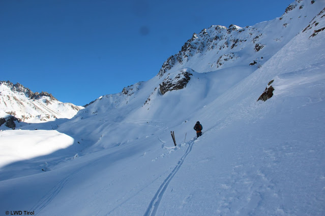
| A similar picture in the Silvretta. On shady slopes the snowpack surface in wind-protected zones is loose. That is the decisive weak layer for freshly generated snowdrift masses. (photo: 19.02.2022) |
 |
| In many places on shady slopes, surface hoar has persisted. Wherever it did, high proneness to triggering can be assumed for fresh snow and snowdrift accumulations which are deposited on it. Regionally this can also be the case in shady forest clearances. Photo taken on 15.01.2022 at 1100m in the Mieming Massif. |
 |
Indicative of this last week was a massive temperature inversion: in the valleys it was colder than in the mountains. Here on the Carnic Ridge, huge surface hoar crystals formed in the valleys.
(photo: 14.01.2022) |
Better point of departure: sunny slopes
Contrarily, on sunny, very steep slopes, the warm temperatures and solar radiation had a big effect on the snowpack. On the one hand, the snowpack became bare in places; on the other, surface crusts formed to an increasing degree. In addition, the water that had seeped into the snowpack which then froze during the cold, clear nights reinforced the bonding of already existing crusts with each other. The upshot: weak layers in the old snow are now much more seldom. Nonetheless, caution is still urged: during the snowfall, weak layers can form inside the masses of fresh snow (graupel or loose, blanketed over fresh snow) particularly in regions with heavy snowfall.
 |
| The slopes becoming bare in sunny terrain. East Tirolean Tauern (photo. 16.01.2022) |
 |
| In extremely steep terrain, moist loose-snow avalanches frequently triggered. (photo: 15.01.2022) |
 |
| Snow profile at 2685m, SW, 36°. Fascinating: the frozen water canals between and beneath the melt-freeze crusts. They have a stabilizing effect. (photo: 19.01.2022) |
Restraint in outlying terrain where snowfall is heavy
It’s clear as glass: after such a long period without precipitation, powder alarms are ringing. Nevertheless, we appeal to the calm, sane reason of all winter sports enthusiasts to not plunge gleefully and carefree into the powder in backcountry, but to adapt to the conditions. Whoever wants to be out in the regions where snowfall is heavy, absolutely needs to exercise a high degree of restraint.


