Thursday, 5 January 2023

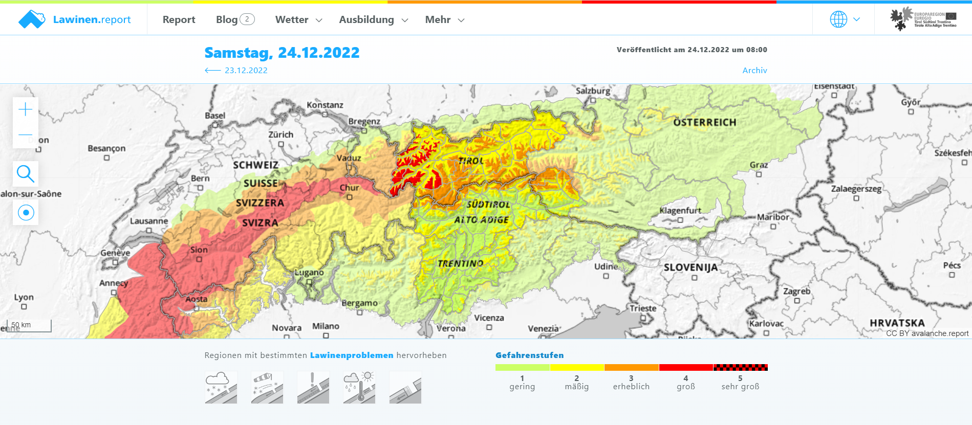
Caution: fresh snowdrifts and persistent weak layer. Danger zones increase with ascending altitude.

Fresh snowdrift masses generally small, but very prone to triggering


Strong westerly winds are currently raging at high altitudes. They are transporting the few centimetres of fresh snow that fell on 3 January and 5 January. The fresh fallen snow is generating (particularly in wind-protected shady terrain) a potential weak layer for the fresh snowdrift accumulations deposited on top of it. Inside the fresh snow there is also graupel and small surface crystals. Snowdrifted masses are currently rather small, thus, the avalanches also small (medium-sized near ridgelines).


15cm Anriss misst dieser Rutsch auf der Nordseite des Zuckerhütl in den Stubaier Alpen. Es handelt sich um ein frisches Triebschneepaket. (Foto: 04.01.2022)
This slide on a north-facing Zuckerhütl slope in the Stubai Alps is a 15 cm fracture. It is a fresh snowdrift. (photo: 04.01.2022)


Etwas Neuschnee auf den Bergen. Unterhalb etwa 2000m regnete es.
Some fresh fallen snow in the mountains. Below 2000 m there was rainfall.


Vielerorts weht in der Höhe recht kräftiger Wind
Quite strong winds were blowing at high altitudes.


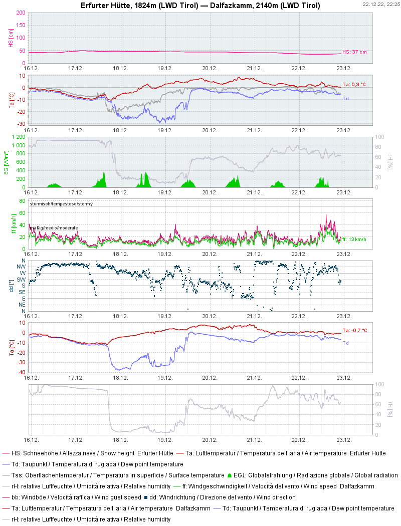
Vergangene Woche war übrigens VIEL zu warm (Neue Rekordwerte seit Messbeginn.) Kaum Niederschlag. Aktuell kräftiger Wind.
Last week it was MUCH TOO WARM (record-breaking since the beginning of measurements). Hardly any precipitation. Strong winds currently.


Persistent weak layer over small areas, particularly on shady slopes


No reports of avalanche releases involving persons were received last week, confirming our estimate: an old snowpack with few inner tensions, corroborating most of the stability tests which have been conducted. (In outlying terrain, one often breaks all the way down to the ground.) Nevertheless, the persistent weak layer remains treacherous. A few avalanche prone locations occur in very steep terrain where there are deep older snowdrift masses. Increasingly this occurs in shady ridgeline terrain. Caution urged in transitions from shallow to deep snow.


Brüche im Altschnee können nicht ausgeschlossen werden, dürften inzwischen aber nur mehr selten möglich sein. Tuxer Alpen (Foto: 30.12.2022)
Fractures in the old snow cannot be ruled out, but will probably be more seldom. Tux Alps
(photo: 30.12.2022)


Springtime conditions at the height of winter


It is much too warm for this juncture of the season. This has brought about a further melting of the small amount of snow on the ground, particularly on sunny slopes. Also, rather good firn-snow conditions were quite out of the ordinary. Increasingly frequent reports about this arrived from southern East Tirol.


Nasse Lockerschnee- und Gleitschneelawinen aus besonntem Gelände. Südliches Osttirol (Foto: 01.01.2023)
Wet loose-snow and glide-snow avalanches in sunny terrain. Southern East Tirol (photo: 01.01.2023)


Der Wärmeeintrag aktiviert das Pflanzenwachstum. Süd. 1300m. Raum Lienz (Foto: 05.01.2023)
The higher temperatures even activated plant growth. South. 1300 m. Near Lienz (photo: 05.01.2023)


Die vergleichsweise brauchbarsten Tourenverhältnisse gibt es aktuell im südlichen Osttirol. (Foto: 04.01.2023)
The best touring conditions, comparatively, are currently in southern East Tirol. (photo: 04.01.2023)


A quick glimpse into the snowpack


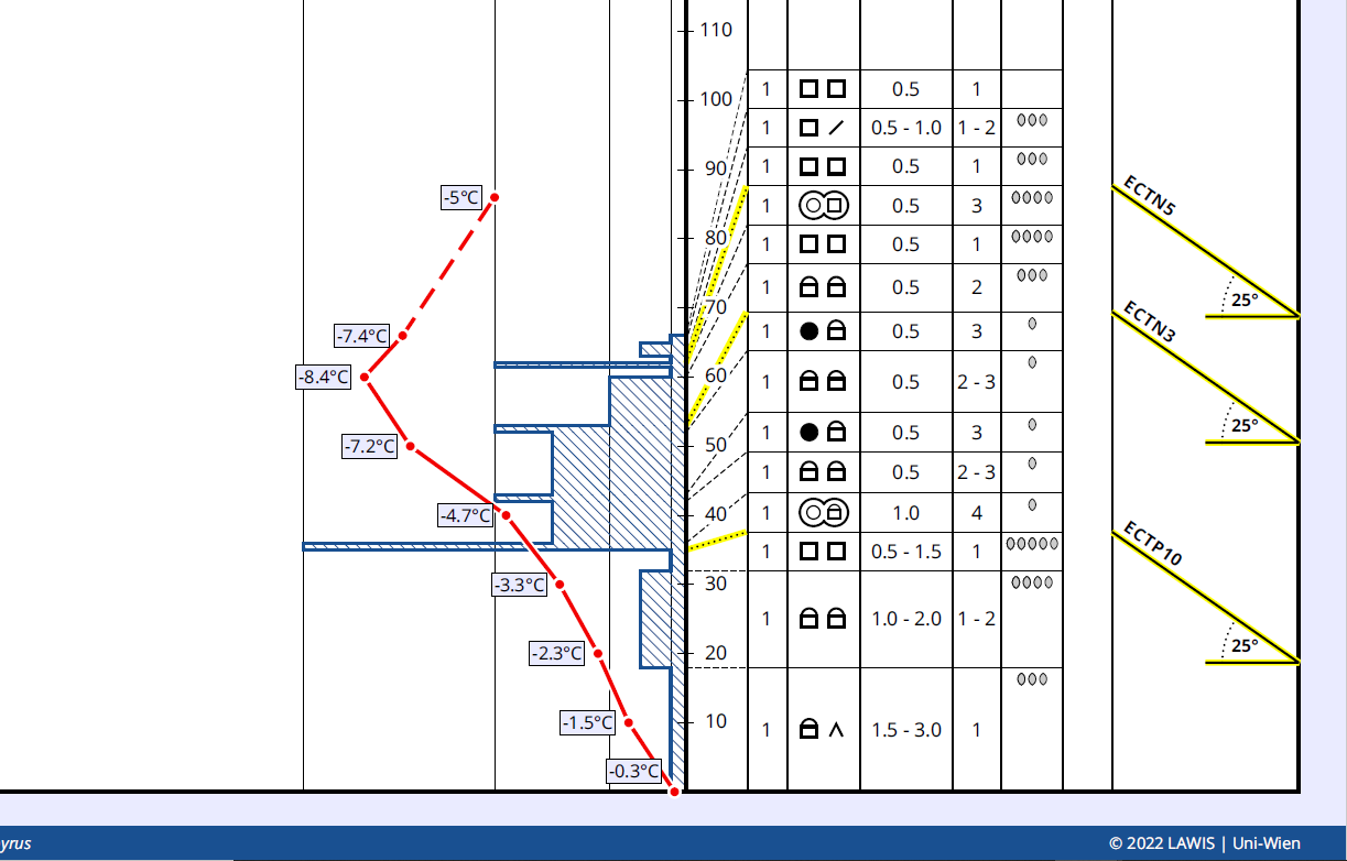
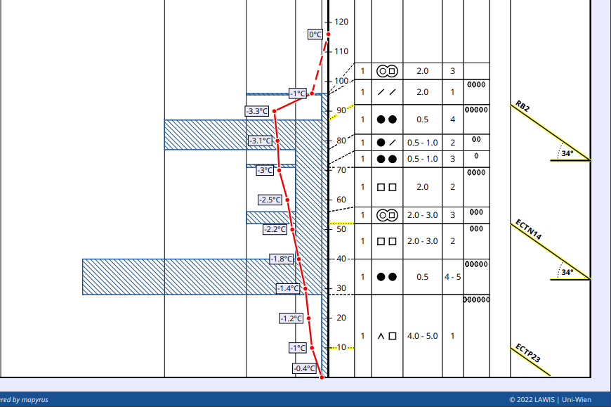
Below, two snow profiles which are quite typical of the current situation.


Schneeprofil Nord, 2375m, 20° in den Westlichen Kitzbüheler Alpen. Stabilitätstests zeigen nur mehr unvollständige Brüche. Die Schneeschichten sind eher weich. Oberflächennahe Krusten lösen sich tendenziell auf. An der Schneeoberfläche lockerer, verfrachtbarer Schnee, hier durchsetzt mit Oberflächenreifkristallen (mancherorts findet man dort auch Graupel) (Profil vom 04.01.2023)
Snow profile, North, 2375m, 20° in the western Kitzbühel Alps. Stability tests demonstrate only partial fractures. The layers are rather soft. Surface crusts tend to trigger. On the snowpack surface: loose, transportable snow riddled with surface hoar crystals (in some places also graupel).
Profile from 04.01.2023


Schneeprofil Ost, 2140m, 33° in den Östlichen Tuxer Alpen. Temperatur- Strahlungs- und Regeneinfluss dominieren in dieser Höhe und Hangausrichtung das Bild der Schneedecke. Der oberflächennahe, tragende Schmelzharschdeckel firnte vergangene Woche mehrmals auf. (Profil vom 05.01.2023)
Snow profile East, 2140m, 33° in the eastern Tux Alps. Temperature impact, solar radiation impact, rain impact dominate at this altitude in this aspect. The near-to-surface melt-freeze crust capable of bearing loads transformed to firn several times last week. Profile from 05.01.2023


Ski runs often possible only on artificial snow


Without artificial snow a ski area would frequently not be in operation, or only on very reduced basis. Some ski areas benefited from the cold days around 10 December.


Schneebänder ins Tal im Zillertal (Foto: 04.01.2023)
Snow ribbons down to the valley. Zillertal (photo: 04.01.2023)


Vorsorglich angelegte Schneedepots. Zillertal Arena (Foto: 04.01.2023)
Snow piles, as a reserve. Zillertal Arena (photo: 04.01.2023)


Ähnliches Bild im Außerfern. Hahnenkammgebiet. (Foto: 01.01.2023)
Similar picture in Ausserfern. Hahnenkamm region (photo: 01.01.2023)


Attention: numerous serious skiing accidents very near ski runs


Since the Christmas holidays, serious - including fatal - skiing accidents due to hardened ski runs and a lack of space for falls outside the runs have been frequent. The Austrian Commission for Alpine Safety has written a press release on the subject. Details can be seen here:  


What’s on the horizon?


According to the weather service (formerly known as ZAMG, rechristened as Geosphere Austria) there are no great snowfalls in view. The weather is expected to be variable. This applies both to the temperature and the wind development. Initially it will be far too warm. Tomorrow, Epiphany, should be quite sunny, after the fogbanks disperse. Thereafter, foehn conditions are expected to increase. Starting on Monday, precipitation and dropping temperatures are foreseen.

Avalanche danger levels are not expected to change significantly to start with. Freshly generated snowdrift masses should be avoided in very steep terrain. Pay special attention to the risks of being swept along in extremely steep terrain.


Schneeverfrachtungen in der Höhe dürften im Verlauf der nächsten Woche immer wieder ein Thema sein. (Foto: 05.01.2023)
Snow transport at high altitudes will be a constant theme over the coming week. (photo: 05.01.2023)

Friday, 30 December 2022

Persistent weak layer is still the dominant problem. Danger zones start at 2200 m.

 Danger zones hard to spot, even for experts


Avalanche danger in the western regions of North Tirol and in northern East Tirol above 2200m and above 2400m continues to be considerable. The underlying problem is the persistent weak layer. That means we are confronted with weak layers in the old snowpack which remain prone to triggering for an extended period of time. Specifically, we are seeing faceted crystals and depth hoar in layers near the ground. These layers often border up against thin crusts. Danger zones are found increasingly on W/N/E facing slopes above 2200m / 2400m and on south-facing slopes above about 2800m.

Typical of the current situation is the highly varied nature of snow depths, but also snow quality: transitions from deep to shallow snow fluctuate just as zones with good and poor snowpack stability. Yet it is also typical of the current situation that the danger zones are really hard to recognize, even for professionals. That means, experience in assessing avalanche danger, together with immense restraint in outlying terrain, are crucial factors when you are en route.


Schneeprofil Glocknergruppe. 2540m. NO. 30°: Bodennahe Schwachschicht aus Schwimmschnee, lche sich relativ leicht stören lässt. Profil vom 26.12.2022 (Weitere Details sh. lawis.at)
Weak layer of depth hoar near the ground which can easily be disturbed. Profile from 26.12.2022 
(for further details, see lawis.at)


Schneeprofil Nördliche Zillertaler Alpen. 2250m. Nord. 32°. Hier konnte bei Stabiliätstests kein Bruch erzeugt werden. Profil vom 28.12.2022 (Weitere Details sh. lawis.at)
Snow profile northern Zillertal Alps. 2250m. North. 32°. In stability tests here, no fracture could be generated. Profile from 28.12.2022 (for further details, see lawis.at)


Schneeprofil Sellrainer Berge. 2520m. NO. 25°. Bruch der Schneedecke in einer bodennahen, kantigen Schicht unterhalb einer dünnen Schmelzkruste. (Details sh. lawis.at)
Snow profile Sellrain Mountains. 2520m. NE. 25°. Fracture of snowpack near the ground in a faceted layer just beneath a thin melt-freeze crust. (for details, see lawis.at)


Seltener werdend: Fernauslösungen von Schneebrettlawinen, wie hier am Beispiel des Kleinen Königtals in der Gurgler Gruppe am 28.12.2022.
Becoming rare: remote triggerings of slab avalanches, like here in Kleines Königtal in the Gurgl Massif on 28.12.2022.


Gefahrenbereiche findet man weiterhin auch im Pistennahbereich. Samnaungruppe. (Foto: 29.12.2022)
Danger zones are still found in the immediate vicinity of ski runs. Samnaun Massif. (photo: 29.12.2022)


Günstiger sind die Verhältnisse abgesehen vom nördlichen Osttirol in den südöstlichen Regionen Tirols. Allerdings liegt auch dort für die Jahreszeit zu wenig Schnee.
More favorable: conditions in the southern regions of North Tirol (apart from northern East Tirol). The problem here is the lack of snow.

Snow depths: (way) below average for the time of year


Some of our observation stations have been in operation since the Avalanche Warning Service Tirol was established in 1960. We extend an enormous vote of thanks to our observers over many years. If you look at the current snow depths there, we have descended below the minimum ever recorded.


Beobachterstation Obergurgl: Bisherige Maxima, Minima und Mittelwert der Gesamtschneehöhe. Magenta: Werte der Wintersaison 2022-23. Noch nie wurde seit Messbeginn um diese Jahreszeit eine so geringe Schneehöhe gemessen.
Observation station Obergurgl: maximum, medium, minimum overall snow depth until now. Magenta line is the season 2022-23. Never before since measurements have been recorded has there been so little snow on the ground.


Beobachterstation Obertilliach: Auch hier ist die Gesamtschneehöhe für die Jahreszeit unterdurchschnittlich.
Observation station Obertilliach: also here, overall snow depth for the season is below average.


Wenig Schnee im Gelände. Bei der Abfahrt besteht ein erhöhtes Verletzungsrisiko durch herausragende bzw. knapp unterhalb der Schneeoberfläche befindliche Steine. Grieskogelgruppe (Foto: 28.12.2022)
Not much snow in open terrain. During a descent heightened risk of injury from rocks sticking out of the snow (or just barely concealed). Grieskogel Massif. (photo: 28.12.2022)


Das Weihnachtstauwetter samt Regen hat der Schneedecke in den meisten Regionen Tirols stark zugesetzt. Mieminger Gebirge (Foto: 25.12.2022)
The thaw around Christmas included rain and had an awful impact on the snowpack in most regions of Tirol. Mieming Massif  (photo: 25.12.2022)


Wetterverlauf der vergangenen Woche im Westen Tirols: Anfangs viel Niederschlag samt Regen (bis etwa 2300m hinauf). Kleine Kaltfront vom 26.12. auf den 27.12.2022. Ab dann trocken mit (für die Jahreszeit) überdurchschnittlichen Temperaturen.
Last week’s weather in western regions: initially lots of precipitation including rainfall (up to 2300m). Minor cold front on 26-27.12. Then dry weather (for this juncture of the season) and above average temperatures.


Tiefe und mittlere Lagen sind häufig aper. Blick Richtung Kaunergrat (Foto: 29.12.2022)
Low and intermediate altitudes are frequently bare of snow. View towards Kaunergrat. (photo: 29.12.2022)


What’s next? Very high temperatures!


The ZAMG Weather Service predicts unusually high temperatures for the next few days. Thus, the year 2022 will end (and go down in history) as the warmest year in the history of measurements, which goes back more than 250 years. Last year also broke some temperature records. This year might break them again. Since there is hardly any snow on the ground at low and intermediate altitudes, the high temperatures will probably not have grave effects on avalanche danger levels. However, we expect increasingly frequent glide-snow and possibly wet-snow slides on sunny slopes and grass-covered terrain. Outside of that, the persistent weak layer will incrementally diminish, unless it becomes so warm and the air so moist that water penetrates down to the ground level layers and leads to heightened proneness to trigger. That is unpredictable at the moment, it simply remains a possible implication.


Mit den warmen Temperaturen wird die Gleitschneeaktivität wohl wieder etwas zunehmen. (Foto: 29.12.2022)
As a result of higher temperatures, glide-snow activity will increase again. (photo: 29.12.2022)


The entire team at Avalanche Warning Service Tirol wishes everyone good health and no accidents in the year 2023!

Wednesday, 28 December 2022

Good explosion triggerings and triggerings by persons confirm: snowpack still weak

Treacherous avalanche situation continues


Right off the bat: particularly in the western regions, but also in northern East Tirol, we have a tenacious problem with a persistent weak layer which is quite pronounced. This problem begins at about 2200m (generally at 2400m), to start with on shady slopes, later frequently on west-facing and east-facing slopes. Above about 2700m it is found increasingly on south-facing slopes.

This is confirmed by stability tests, also by slab avalanches which have been triggered by winter sports enthusiasts and in some regions by successful artificial triggerings through explosives over the last few days. The artificial triggerings were reported to us from the western regions where snowfall was heaviest.

Slab avalanches were triggered due to the well formed “slab” (snowfall, warmth, wind) which was quite extensive in places and occurs repeatedly in seasons when the snow depths are below average.

The situation is treacherous also because the avalanche prone locations in outlying terrain are difficult to recognize and distributed in highly irregular fashion. In addition, we observe high variations not only in snow depths, but also in snowpack stability.


A brief review of the last few days:


Vom 23.12. abends bis inkl. 25.12.2022 stuften wir die Lawinengefahr im Westen des Landes in der Höhe mit "groß", also Stufe 4 ein. Es handelte sich dabei um ein "Wintersportler-Groß"
From the evening of 23.12 through 25.12.2022 in western regions, the Danger Level was “high” - level 4. This was the “winter sports high” we wrote about.


Wetterstation Dias/Kappl im neuschneereichen Westen des Landes. In der Höhe ca. 50cm Neuschnee. Erwärmung während des Schneefalls. Am 25.12. Schönwetter, dann kleine Kaltfront mit Wind und folgender Wetterbesserung.
Dias/Kappl weather station in the west where snowfall was heaviest. About 50cm of fresh snow at high altitudes. Rising temperatures during the snowfall. On 25.12 fine weather, then a small cold front with winds, subsequently improved weather.


In tiefen und mittleren Lagen schmolz der Schnee durch Regen dahin. Die Regengrenze lag meist um 2300m. Oberhalb etwa 2200m-2400m schneite es v.a. im Westen des Landes 30-50cm, lokal auch mehr.
At low and intermediate altitudes  rainfall melted the snow. Rainfall level was  mostly around 2300m. Above 2200-2400m 30-50cm of fresh snow was registered, mostly in western regions, more from place to place.


A few avalanches triggered by winter sports enthusiasts


We were lucky in Tirol that over the Christmas holidays no one suffered injuries from avalanches. We are aware of several avalanche releases which involved winter sports enthusiasts. Here a brief selection:


Lawinenabgang Lampsenspitze vom 25.12.2022. NO. 2700m. Person konnte ausfahren. (Foto: 25.12.2022)
Avalanche release Lampsenspitze on 25.12.2022. NE, 2700m. The person could evade it.
(photo: 25.12.2022)


Weiterer Lawinenabgang Lampsenspitze vom 26.12.2022. Ost, 2840m. Keine Verschütteten. (Foto: 26.12.2022)
Another avalanche on the Lampsenspitze on 26.12.2022. East, 2840m. No one caught. (photo: 26.12.2022


Lukas Ruetz, einer unserer Beobachter, recherchierte aufgrund von Webkameras (großflächige) Lawinenabgänge im Bereich des Pirchkogels und des Hinteren Grieskogels. Rote Ellipse: Spontaner Lawinenabgang um 10:40 Uhr. Türkise Ellipse: Spontaner Lawinenabgang um 11:10 Uhr. Grüne Ellipse: Lawinenauslösung durch Wintersportler um 13:00 Uhr. 2600m Nord und Ost
Lukas Ruetz, one of our observers, researched avalanche releases with large-scale lens web cameras near the Pirchkogel and Hinteren Grieskogel. Red ellipse: naturally triggered avalanche at 10:40 am. Turquoise ellipse: naturally triggered avalanche at 11:10 am. Green ellipse: avalanche released by winter sports enthusiasts at 1:00 pm. 2600m, N and E.


Foto vom Anriss Pirchkogel / Ht. Grieskogel auf 2660 Nord. Eingekreist: Aufstiegs- und Abfahrtsspur eines Wintersportlers. Vieles spricht dafür, dass die Lawine durch eine Person im Aufstieg im Bereich des Kreises fernausgelöst wurde. (Foto: 26.12.2022)
Photo of Pirchkogel fracture / Hr. Grieskogel at 2660 N. Encircled: ascent and descent track of a winter sports enthusiast. All evidence points to the avalanche having been remotely triggered by the person in the area of the circle. (photo: 26.12.2022)


Underlying this theory regarding the above avalanche is the significantly rising temperature during the day, which had an impact on the characteristics of the “slab.”


Eingekreist: Temperatursprung am 25.12.2022. Station Kühtai im Nahbereich des Lawinenabgangs
Encircled: temperature leap on 25.12.2022. Kühtai weather station in the vicinity of avalanche.
 

Im unmittelbaren Nahbereich der Pirchkogellawine löste sich eine Schneebrettlawine als sich ein Wintersportler im Bereich der Ellipse bei der Abfahrt befand (Foto: 26.12.2022)
In the immediate vicinity of the Pirchkogel avalanche, a slab avalanche was triggered as a winter sports enthusiast was descending near the encircled area. 2595m NE (photo: 26.12.2022)


Ein Lawinenabgang am Tiefenbachferner. 2830m, NO. Einfahrender Skifahrer konnte ausfahren, meldete dies aber nicht bei der Leitstelle Tirol unter 140. Erst nach einer großangelegten Suchaktion konnte der Einsatz abgebrochen werden. (Foto: 25.12.2022)
An avalanche release on Tiefenbachferner glacier. 2830m, NE. The skier was able to ski out of the plummet path but did not report it to headquarters (tel. no. 140). Only after a big rescue operation was the emergency search terminated. (photo: 25.12.2022)


Lawinenabgang Rietzer Grießkogel vom 27.12.2022. Lawine wurde im Aufstieg fernausgelöst. Person wurde teilverschüttet. 2700m. SW
Avalanche release Rietzer Griesskogel on 27.12.2022. Avalanche was remotely triggered during the ascent. A person was partially buried. 2700m, SW


Lawinenauslösung Weißer Knoten in der Glocknergruppe vom 27.12.2022. Der Bruch breitete sich orographisch links noch weiter aus. ca. 2600m, Ost
Avalanche release Weisser Knoten in the Glockner Massif on 27.12.2022. The fracture expanded orographically left. Appx. 2600m, E


Lawineneinsatz aufgrund einer "Kunstschnee"-Gleitschneelawine im Bereich der Untermarkter Alm in Hochimst (Foto: 27.12.2022). Der Einsatz wurde in den Abendstunden abgebrochen, nachdem mit sehr hoher Wahrscheinlichkeit davon ausgegangen werden konnte, dass keine Personen verschüttet waren. (Übrigens löste sich am 05.12.2018 an derselben Stelle eine ebensolche "Kunstschnee"-Gleitschneelawine.)
Avalanche operation due to a glide-snow avalanche of artificial snow near Untermarkter Alm in Hochimst (photo: 27.12.2022). The operation was terminated in the evening after all signs pointed to no one having been buried. (Incidentally, on 05.12.2018 on the very same spot, another such glide-snow avalanche of artificial snow was triggered.) 


Am Karnischen Kamm: Gleitschneerutsche auf steilen Wiesenhängen. (Foto: 26.12.2022)
On Carnic Ridge: glide-snow slide on steep grass-covered slopes. (photo: 26.12.2022)


Der Wind wehte kürzlich in der Höhe sehr stark. Hier ein Bild von Schneeverfrachtungen in der Gurgler Gruppe (Foto: 26.12.2022)
Winds were briefly blowing at very strong velocity at high altitudes. Above, snow transport in the Gurgl Massif. (photo: 26.12.2022)


Outlook

The regionally quite treacherous avalanche situation will continue. The recently formed “slab” is still quite pronounced, thus, virtually demanding expansion of a release upon fracture in the weak layer of the snowpack. For that reason we recommend level-headed restraint in outlying terrain. Besides, due to the poor snow situation, conditions for skiing and freeriding tours are  rather bad in general.

Saturday, 24 December 2022

One more plea to all winter sports enthusiasts: 1st fine-weather day after windblown precipitation is accident-prone!

“Lump Risk” : the snowpack is prone to triggering - brilliant and fine weather - high likelihood of avalanche releases involving persons! Caution urged particularly in Tirol’s western regions above 2400 m.


Once the clouds and the fogbanks have dispersed, particularly in the northern regions, Christmas Day according to ZAMG Weather Service will be brilliantly beautiful. In the western regions where there has been 30 to 50 cm of fresh snow registered above 2400 m since 23.12, locally more, we now have a treacherous situation: “winter-sports high” avalanche danger. Atop an often weak old snowpack there is now fresh snow deposited, winds and warmth have formed a pronounced slab. For tomorrow, 25.12, we foresee an extremely trigger-sensitive snowpack in very steep terrain above 2400 m (the rainfall level over recent days). Increasingly on W/N/E facing slopes and in general near ridgelines. On south-facing slopes the snowpack is prone to triggering only in high alpine regions. Even remote triggerings are possible because the slab is so pronounced. Therefore: keep distances, especially on very steep W/N/E facing slopes at high altitude. Especially on north facing slopes.


Christmas Day will be an accident-prone day, particularly in the western regions.

Friday, 23 December 2022

Turbulent weather: snowfall, rainfall, wind & warmth. Increase of avalanche danger to “winter sports high”

Significant increase in avalanche danger


Warm front and cold front

A warm front will bring instabile, stormy and very mild mountain weather our way on Friday, 23.12.2022, according to ZAMG Weather Service Innsbruck. In places there will be intensive precipitation, in many places below about 2000 m as rain. Precipitation will be most intensive in the western part of North Tirol: 30-50 mm is expected there on 23.12. This correspondes to about 30-50 cm of fresh snow. On Christmas Eve, 24.12, a cold front will follow on its heels. In the morning, frequent snowfall and rainfall in North Tirol and in the northern regions of East Tirol. In the afternoon it will slacken off. Southern East Tirol will get hardly any precipitation.


Prognostizierter Neuschnee der kommenden Tage. Niederschlagsgefälle von West nach Südost.
Forecast fresh snow over the next few days. Precipitation gradient from west to southeast.


Der Niederschlag wird häufig von starkem bis stürmischem Wind begleitet.
Precipitation will frequently be accompanied by strong to storm-strength winds.


Die Schneefallgrenze am 23.12. um 00:00 Uhr...
Snowfall level at midnight, 23 December


Die Schneefallgrenze steigt im Laufe des Tages. Hier abgebildet: Die Schneefallgrenze am 23.12. um 16:00 Uhr...
Snowfall level will ascend during the course of the day. Above: snowfall level at 4:00 pm on 23.12.2022


Niederschlags- und Windprognose für eine der niederschlagsreichsten Regionen Tirols. Der Niederschlag beginnt in der Nacht vom 22.12. und zieht sich bis zum Heiligen Abend. Starker Wind. Schwankende Temperaturen.
Precipitation and wind forecast for one region where it will be heaviest. Precipitation will begin during the night of 22.12 and persist until Christmas Eve. Strong winds. Fluctuating temperatures.


Impact on avalanche danger

Currently we expect a significant increase in avalanche danger during the course of the day. If the forecast amounts of precipitation occur, Danger Level 4 (high) will be reached in the afternoon / early evening. This is a so-called “winter-sports high” – the snowpack is weak and prone to triggering; there are numerous danger zones; the likelihood is great that winter sports enthusiasts can trigger slab avalanches. In addition, we expect naturally triggered avalanches. Most will be medium-sized (typical magnitude of skier’s avalanche). Especially on shady slopes, these can grow to large size. Here are the reasons:
  • Wherever it snows, the snow will initially fall at lower temperatures. During the snowfall temperatures will rise. Thereby, warm snowfall will be deposited atop colder snowfall, i.e. a “slab” on a potentially weak layer. Depending on how much the temperature rises, the snowpack will be weakened with varying swiftness. Small-to-medium avalanches will release naturally, more and more as the temperature rises. The “slab” will release ever larger masses of snow. That slab also heightens the likelihood of remote triggerings.
  • The old snowpack is weak in many places. This is increasingly the case on west-facing, north-facing and east-facing slopes above 2200 m. Fractures in the weak layers inside the old snowpack are possible from the impulse of naturally triggered superficial avalanches in the fresh fallen snow. On the other hand, this is possible “only” through the weight of fresh fallen snow. The old snowpack on north-facing slopes above 2200m is least favourable of all. On west-facing and east-facing slopes the old snowpack is triggerable above about 2400m. On south-facing slopes, this is the case mostly in high alpine terrain. If fractures occur in the old snowpack, the avalanches can grow to large size.
  • In zones with rain impact the snowpack is moist or thoroughly wet already and will become wetter still. The snowpack will forfeit its firmness. We expect numerous wet loose-snow avalanches but also increasingly frequent glide-snow releases. Due to the shallow snowpack, most of these will be small sized, in isolated cases medium sized.

Impressions of the current situation


Risse in der Schneedecke als Alarmzeichen einer störanfälligen Schneedecke. Sattelberg, am 14.12.2022. Seit dem Foto ist eine gute Woche vergangen. Inzwischen gibt es nur mehr wenige Rückmeldungen über Rissbildungen und Wummgeräusche.
Cracks in the snowpack: the alarm signal for a trigger-sensitive snowpack. Sattelberg, 14.12.2022. The photo is more than a week old. In the meantime we have received few reports of glide cracks and whumpf noises.


In tiefen und mittleren Lagen wurde die Schneedecke feucht. Der Wind hat zugelegt.
At low and intermediate altitudes the snowpack is moist. (2nd graph above with temperature, thawing point and snow-surface temperature). The winds have intensified.


Durch die Erwärmung, aber auch durch kürzlichen Regen beobachtete man vermehrt nasse Lockerschneelawinen und Gleitschneerutsche.
Due to higher temperatures and recent rainfall, increasingly frequent wet loose-snow avalanches and glide-snow slides have been observed.


Nassschneerutsche Nordseite Kitzbüheler Horn (Foto: 20.12.2022)
Wet snowslide, north side of Kitzbühler Horn (photo: 20.12.2022)


"Noppenpulver" wurde inzwischen durch den Wärmeeintrag meist zerstört. Tuxer Alpen (Foto: 18.12.2022)
Knobby powder snow - now gone, due to the rise in temperatures, Tux Alps (photo: 18.12.2022)


Profil im Bereich des Hochzeigers. Nord, 2340m. Bodennahe Schwachschicht, die bei Belastung brechen kann.
Profile near Hochzeiger, north, 2340 m. Weak layer near the ground which can fracture upon loading.


Wechsel von härteren und weichen Schichten. Axamer Lizum. West. 2260m. 28°. An diesem Standort konnten bei Stabilitätstests keine durchgehenden Brüche erzeugt werden. (Foto: 22.12.2022)
Sequence of hard and soft layers. Axamer Lizum, west, 2260 m, 28°. At this spot no thorough fractures were generated in our stability tests. (photo: 22.12.2022)


Der Wind hat bereits zugelegt und verfrachtet in großen Höhen bereits Schnee. Hier  Schneefahnen in der Gurgler Gruppe (Foto: 22.12.2022)
Winds have already intensified and transported snow at high altitudes. Above, snow plumes in the Gurgl Massif. (photo: 22.12.2022)


Treacherous and accident-prone days lie ahead for winter sports enthusiasts. Immense restraint is called for.

On Sunday, Christmas Day, 25.12, the weather will improve. It will remain mild. Please heed this warning: in the regions where the most snowfall occurs we will have a very tense avalanche situation. That is - as we all know - when most of the avalanche accidents occur, in that brief time window. Therefore, act defensively. The inexperienced are advised to remain on the secured ski runs.