In a nutshell
It seems as if a warm winter with too little snow just woke up and wanted to make up for lost time. This evening, on 09.05.2023, a cold front is arriving which will bring lots of fresh snow to the mountains. Avalanche danger will increase. Frequent naturally triggered releases can be expected over the coming days.
Some fresh snow in the mountains
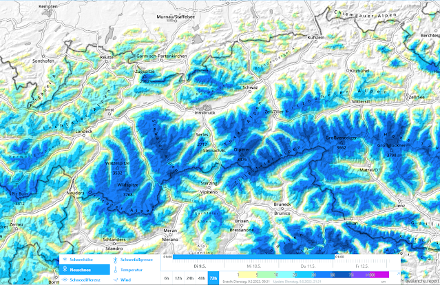
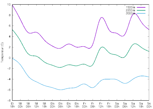
According to GeoSphere Austria, 40-60mm of precipitation can be expected over far-reaching areas by Thursday, 12.05, locally up to about 90mm. In the mountains that means generally 50cm of fresh snow, significantly more from place to place. The zero-degree level is expected to descend swiftly from 2900m down to 2200m to begin with. Between Wednesday, 10.05, and Thursday, 11.05, the zero-degree level will reach its lowermost altitude at about 1800m.
 |
| 72-hr fresh snowfall forecast 09.05.-11.05.2023 |
 |
| The next few days will be wet, with light winds. During the precipitation, the snowfall level will descend. |
 |
| Snowfall level for 11.05. at 05:00 a.m. |
 |
| Temperature development at various altitudes |
Increase in avalanche danger including naturally triggered avalanches
Avalanche activity over the last few days
The last few days - just as predicted in our last Blog - were marked by naturally triggered releases. These were large, in isolated cases also very large slab avalanches which sometimes plummeted down to low altitudes. Most of them which were observed and reported triggered on north-facing slopes at 2600-2900m. On sunny slopes they occurred nearly exclusively in high alpine terrain (above 3000m). The cause of the releases was progressive wetness, and thereby weakening, of the weak layers near ground level which formed in early winter. The triggering impulse came frequently from loose-snow avalanches, in isolated cases from breaking cornices.
_bearb%20(2).png) |
| Slab avalanche triggering, probably from a small cornice breaking - Stubai Glacier (photo: 05.05.2023) |
.jpg) |
| Avalanche triggering in northern Zillertal Alps on 08.05.2023. The hiking trail which brushes the plummet path was closed as a precautionary measure. (photo: 08.05.2023) |
Avalanches over the next few days
During the next few days we expect a relatively high frequency of avalanche activity. In the high altitude zones where snowfall is heaviest, particularly on north-facing slopes above 2600m and in other aspects at high alpine altitudes, the additional load of the fresh snow will cause avalanches to trigger naturally. Just as in recent days, these releases can plummet down to green zones.
During interims in precipitation – when there is (diffuse) radiation or when temperatures rise after snowfall – numerous loose-snow avalanches will trigger on extremely steep slopes. Here too, the impulse of loose-snow avalanches can trigger slab avalanches.
Wherever there is ample snowfall on steep grass-covered slopes, glide-snow slides and glide-snow avalanches can be expected for a short time.
A serious avalanche situation - Heed avalanche closure zones!
The situation will be quite serious over the next few days. Whoever is out in open terrain needs to be aware of the heightened risks of avalanches. Please heed the avalanche closure zones on hiking trails, forest roads, etc. As the photo above demonstrates, they are more than justified.
The situation will be quite serious over the next few days. Whoever is out in open terrain needs to be aware of the heightened risks of avalanches. Please heed the avalanche closure zones on hiking trails, forest roads, etc. As the photo above demonstrates, they are more than justified.
_bearb%20(2).png)