In a nutshell...
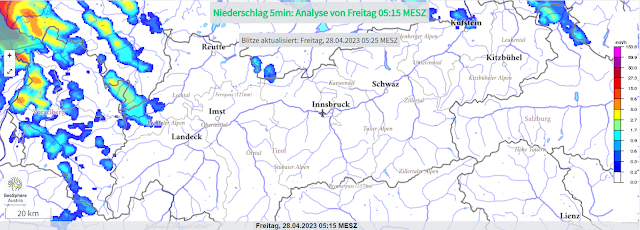
April weather conditions persist. A warm front today and tomorrow (28-29.04) is bringing rain up to 2300 m, most of which (30mm) will be north of the Inn. At high altitudes, strong westerly winds will be blowing. On the weekend, dispersed clouds, more pleasant weather before on 1 May slight foehn-impact and during the daytime more rainfall can be expected. Rain and warmth will push the wet-snow problem to the forefront next week.
 |
| Precipitation is coming, will spread throughout Tirol today, 28 April. |
Rain + warmth weakening the snowpack
The snowpack was thoroughly moistened several times this winter: on steep sunny slopes up to high alpine zones, on shady slopes up to 2500 m. This is decisive in assessing avalanche danger resulting from rainfall. If the rainfall level is at 2300 m (as forecast), then the near-surface layers (of recently fallen fresh snow) will be weakened.
 |
| Fresh snowfall from 24-25 April. Water seepage can weaken the snow (which had settled) in many places. |
.jpg) |
| Near-surface loose-snow avalanches will become more frequent due to rain. (photo: 25.04.2023) |
If the rainfall level is further up, heightened proneness to triggering is also indicated on shady slopes. Both rainfall intensity and nocturnal outgoing longwave radiation play a role in the snowpack from 27-28.04. Wherever nighttime skies were clear for longer, the water seepage is delayed due to a thin melt-freeze crust forming.
 |
| Initially clear nighttime skies... |
 |
| In early morning: overcast. |
Above all else, naturally triggered slab avalanches cannot be ruled out on shady slopes if the snowpack is thoroughly wet. Fractures in near-surface weak layers (formed since the end of March) can lead to fractures of more deeply embedded layers in the snowpack.
Short review of the last week
The week was marked by the month: April. Following very warm days last weekend (22-23.04) there was a cooler phase. In the meantime, temperatures have risen again. A warm front is now bringing rain.
.jpg) |
| High moisture in the atmosphere and warm temperatures on 23.04 - Golzentipp - southern East Tirol |
.jpg) |
| Deteriorating conditions on 23.04.2023 |
.jpg) |
| Snowfall in the Weisskugel Massif (photo: 25.04.2023) |
.jpg) |
| Quite good conditions in the Silvretta (photo: 27.04.2023) |
.jpg) |
| Cornices are a threat to the snowpack with large additional loading. Silvretta (photo: 27.04.2023) |
.jpg) |
| Even if the crevices were covered in April, they remain a big threat. (photo: 25.04.2023) |
Good tour planning and time organisation
...both help. Choose a suitable touring goal. If it is not too high, the conditions on ski pistes are currently quite good.
At high altitudes the danger zones are mostly on very steep shady slopes due to near-surface weak layers (persistent weak layer due to cold-on-warm since the end of March). Particularly between 2600 and 3000m this is the case. In high alpine regions (above 3000m) isolated spots also on sunny slopes.
After snowfall, loose-snow avalanches in extremely steep terrain, in high alpine regions esp. near ridgelines, high attentiveness to fresh snow is required.
 |
| 24-hr fresh snow forecast. Up to intermediate altitudes, rainfall (not visible in this graph). |
