In a nutshell...
Till now the Easter holidays have been much too cool for this juncture of the season (Easter has been colder than Christmas). On the other hand, that meant that the snow which fell this week was able to remain good powder for a long time. The near-surface weak layer problem generated by dp.4 (cold on warm) currently seems most threatening above 2600m. Danger zones are rare. It occurs mostly extremely steep N/NE/E facing slopes.
Mostly favorable avalanche situation
Reports from winter sports enthusiasts, snowpack analysis and information about avalanches which have released reveal a mostly favorable avalanche situation.
.jpg) |
| Last week had lots of great powder. Carnic Alps (photo: 06.04.2023) |
.jpg) |
| Another snapshot of terrific powder in the Sellrain mountains. (photo: 06.04.2023) |
Near-surface weak layers found increasingly on N/NE/E facing slopes at 2700-3100m
We were able to observe the danger pattern described in our last blog (cold on warm) in many places, but stability tests mostly showed only partial fractures in the weak layer. That fits with the fact that most of the dp.4-relevant avalanches last week occurred in extremely steep terrain. What was striking, was how many of them were on N/NE/E facing slopes at 2700m-3100m (Wasserkar-Weikugelgruppe / Müncher Abfahrt-Weißkugelgruppe / Zirmkogel-Gurgler Gruppe / Wildgratscharte-Alpeiner Berge / Stöcklengrube-Alpeiner Berge / Federbettkees-Zentrale Zillertaler Alpen / Kleiner Happ-Venedigergruppe / Wagenstein-Östliche Deferegger Alpen).
Minor snowdrift problem
The snowfall from the beginning of this week occurred at low temperatures and was transported at high altitudes. When snowdrifts are deposited on cold, loose fresh snow (even snow-fluff was observed) there is a heightened likelihood of slab avalanches triggering. With sufficient experience, such danger zones are easily recognized and can be circumvented. The danger zones currently (07.04.2023) occur especially on very steep ridgeline shady slopes.
.jpg) |
| Snowdrift accumulations adjacent to a ridgeline in the Allgau Alps (photo: 04.04.2023) |
Caution: cornices
Cornices have become quite pronounced this spring. Keep an eye on the risks of taking a fall. In addition, additional loading caused by a breaking cornice can trigger an avalanche.
.jpg) |
| Cornices near the ridgeline: a potential alpine danger (photo: 06.04.2023) |
.jpg) |
| Avalanche due to a cornice breaking on Gufelseejoch (photo: 04.04.2023) |
Coupled to alpine dangers are the glaciers: increased risk of falling into crevices due to lack of snow.
Short review of this last week
A quick glimpse at the weather is easiest through an automated weather station.
 |
| At month’s end it was still warm, the snowpack surface was moist. Then some snowfall, initially accompanied by wind. Thereafter, temperatures dropped. Conditions improved rapidly. |
 |
| Fresh snowfall at the beginning of the week (02.04-03.04), most of which fell in eastern North Tirol and in northern East Tirol. |
.jpg) |
| A cold week by and large...ice hanging from a piste vehicle on Stubai Glacier. (photo: 04.04.2023) |
What’s next?
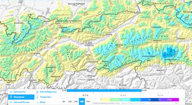
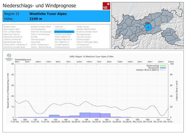
April weather variability will continue, with some snowfall over the Easter holidays. No significant change is expected in the avalanche situation.
 |
| 48-hr fresh snow forecast from today, Good Friday, 07.04.2023 |
 |
| Until Easter Monday, repeated bouts of precipitation. Only light winds. Cold. |
HAPPY EASTER!
We wish you Happy Easter and a period which is both high in enjoyments and low in accidents out in backcountry terrain. Yours truly, the team of the Avalanche Warning Service Tirol.
.jpg)
.jpg)