In a nutshell...
April is quite justly famous for its caprices with the weather. This is having rapid effects on avalanche dangers. Due to an expected surge in temperatures tomorrow (Saturday, 22.04) the danger will increase during the course of the day. More frequent naturally triggered avalanches will be the result. Savvy tour planning and exercising personal restraint are crucial.
Following snowfall, increasingly wet and weak snowpack
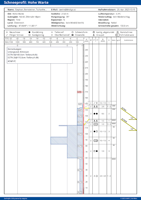
Following a striking springtime injection at the end of March and the coldish phase which came in its wake, we now adjust our sights to the snowpack moistening or becoming thoroughly wet. Current snowpack analysis shows temperature reserves inside the snow cover to be nearly used up, even on shady slopes below 2700m. That means, the snow temperature is already 0° or pretty close to it. Warm temperatures, high air moisture (convective cloud build-up during the day) and (diffuse) solar radiation lead to the snowpack swiftly becoming thoroughly wet. Water seepage weakens it further. As of then, likelihood of slab avalanches being triggered by winter sports enthusiasts rises, as does likelihood of naturally triggered avalanches (slab, loose-snow, glide-snow).
 |
| In this snow profile taken yesterday (20.04) at 2120m on a 35°-steep north-facing slope in the northern Zillertal Alps, the snowpack is thoroughly isotherm. |
Heightened avalanche activity - for a short time, large-sized avalanches are possible
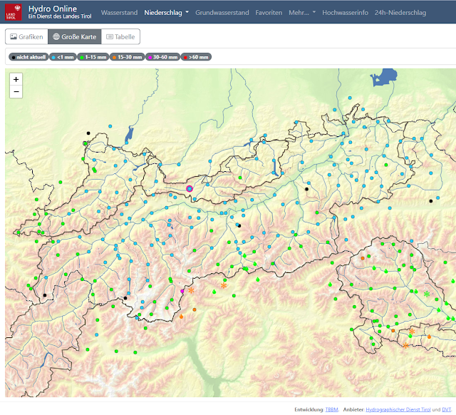
As mentioned, we currently expect heightened avalanche activity. In the areas where recent snowfall has been heaviest (near the border to South Tirol in the Main Alpine Ridge) numerous loose-snow avalanches can be expected today (21.04). Due to the additional loading from loose-snow avalanches, in their wake slab avalanches could also be triggered near persistent weak layers at mid-level in the snow cover and at ground level. Thereby, large-sized releases could be generated.
 |
| 48-hr fresh snow forecast from 20.04.2023 |
 |
| 24-hr precipitation distribution (cut-off date: 21.04.2023 7:20 am) |
Impressions from last week
.jpg) |
| View from Hochstein above Lienz, in the Lienz basin (photo: 14.04.2023) |
.jpg) |
| A slab avalanche triggered by a winter sports enthusiast near Flimjoch, bordering on the Samnaun Massif in Switzerland; north 2700m 35° (photo: 18.04.2023) |
.jpg) |
| Graupel - often accompanying snowfall in the last few weeks (photo: 19.04.2023) |
.jpg) |
| Visible on the right side of the persons is a recently triggered loose-snow avalanche. Gurgler Massif (photo: 19.04.2023) |
What’s on the horizon?
On Sunday, 23.04, a cold front will again bring precipitation. Weather conditions will remain instable. The forecasts are still uncertain. Precipitation in showers is anticipated, which means we’ll have heightened potential of graupel accompanying the snowfall. Wherever snowfall is intensive graupel can quickly form a weak layer for slab avalanches to trigger from. The situation demands meticulous backcountry tour planning. Apart from frequently poor snow quality, it is also necessary to keep an eye on heightened avalanche risks in open terrain. The only place where conditions tend to be better is at very high altitudes where the warmth has less of an effect.

