Winter has arrived in Tirol. Since Saturday, 8.12.2018, more than 100 cm of fresh snow has been registered at high altitudes.
 |
| Enormous amounts of fresh snow in far-reaching parts of Tirol |
Review
On Friday 7.12 in far-reaching parts of Tirol, an intermediate high generated very pleasant weather conditions and mild temperatures. The zero-degree level during the day was at nearly 3000 m. The snow situation in widespread areas of Tirol was still rather meagre at that juncture. The snowpack, where there was one, was heavily wind-impacted and erratic.
On Friday night and during the early morning hours of Saturday (8.12) a severe cold front moved in from the northwest, temperatures dropped abruptly (about 10° within the shortest imaginable time). Accompanied by storm-strength winds there was 5-10 cm of snowfall registered, the snowfall level at around 1000 m. Intensive graupel was also observed.
 |
| Lots of graupel has been observed over the last few days, Inn Valley (photo: 10.12.2018) |
After a warm front brought some relief and only a touch of precipitation on 8.12, another cold front reached us on Saturday night in another storm-riddled NW airstream. The snowfall level descended down to the valley floor.
In North Tirol and the Hohe Tauern, 40-100 cm of fresh snow was registered at high altitudes, from place to place even more. Most was in typical NW barrier-cloud regions of the Silvretta and Samnaun groups over the Verwall group and Allgäu Alps into the Karwendel, as well as in the Wilden Kaiser. In the Deferegger Alps it snowed far less, about 10-20 cm; in the Lienz Dolomites, hardly at all.
 |
| In central Oetztal at 1400 m on Monday 10.12, about 35 cm of fresh snow was registered, about 50 cm at the treeline (photo: 10.12.2018). |
 |
| Wintery landscape also in the Zillertal (photo: 10.12.2018). |
As a consequence of the strong to storm-strength winds, wide-ranging snowdrift accumulations were generated above the treeline.
 |
| Wind as the architect of avalanches is here transporting the fresh snow, Tux Alps (photo: 08.12.2018) |
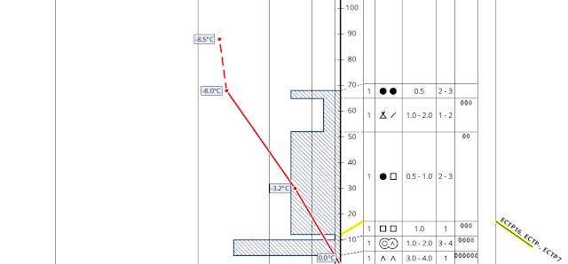
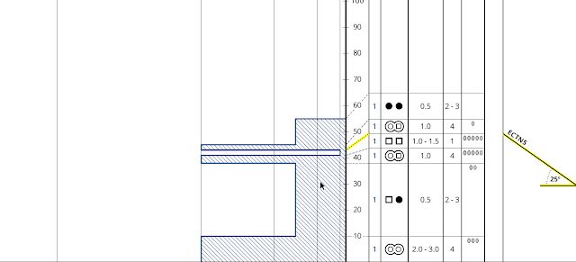
Potential weak layers for slab avalanches can usually be found inside the fresh snow mass in the form of cold fresh snow or graupel. Naturally triggered avalanches reported during this period of precipitation presumably fractured in these weak layers.
Inside the old snowpack are weak layers on shady slopes between about 2400 and 2900 m. These consist of faceted snow crystals embedded between crusts. Stability tests have shown highly varied fracture tendencies, from high to low fracture propagation.
One also finds in high alpine, glaciated, shady terrain still expansively mettamorphosed snow crystals right on the glacial ice. This layer can probably trigger only in exceptional cases due to the compacted snow layer on it which goes back to the end of October.
Outlook
As weather conditions improve from the west, the wind will also recede. Snowdrift accumulations are covered in some places, making them difficult to recognize. Since the prevailing low temperatures will persist, it will presumably take a few days for the drifted masses to bond well with the weakened layers inside the fresh snow masses. Thus, we advise a high degree of restraint in very steep terrain. Caution: the first period of beautiful weather following a period of storm-ridden snowfall is always prone to accidents.
 |
| Throughout Tirol, it was shiveringly cold on Tuesday morning (11.12). These low temperatures are expected to persist over the coming few days. They will hinder a rapid consolidation of the snowpack. |
Otherwise needful of heed: on steep, grass-covered slopes the fresh snow can glide. Zones below glide cracks should be avoided whenever possible.
 |
| Also technical snow can be swept away as a glide-snow avalanche, as here in the Hochimst ski area. In the interim, this area is cloacked in deepest winter (photo: 05.12.2018). |


