Sunday, 5 February 2023

Numerous avalanches - also fatalities. Successful artificial triggerings. Cluster risk in open terrain.

 Numerous avalanches involving persons


We are facing an extraordinary and dangerous situation for winter sports enthusiasts, with high avalanche danger above 1600 m. Confirmation of this during the last two days came from numerous avalanches in which persons were involved. This morning (04.02) there were 29 reports made to headquarters in Tirol. Yesterday (03.02) there were 10 reports. On 03.02 a person died in an avalanche in Königstal in the Gurgler Massif. Today on 04.02 a youth was killed in the region of the Neuhütten Lift near Kalterbach. In two further avalanche accidents (Törli - St. Anton; Hoher Aifner - Kaunerberg) there are 3 persons missing.


Überblick über die von der Leitstelle Tirol am 04.02.2023 gemeldeten Lawinenabgänge in Tirol. Gestern am 03.02. waren es zusätzliche 10 Lawinenabgänge. (c) Landeswarnzentrale Tirol
Overview of avalanches reported to headquarters Tirol. Yesterday on 03.02 there were an additional 10 avalanches. (c) Landeswarnzentrale Tirol 


Numerous naturally triggered avalanches

The high proneness to triggering of the snowpack was demonstrated by numerous naturally triggered avalanches. These were medium, large and in isolated cases also very large avalanches. The biggest ones triggered at very high altitudes particularly in leeward ridgeline zones. The crucial factor in these releases was not only the high additional weight on the snowpack due to fresh snow and snowdrifts in huge masses but also today’s solar radiation.


Successful artificial triggerings throughout the land

We were also informed that artificial triggerings in the major areas of precipitation were highly successful.


Cluster risk in open terrain

High danger means there are a bevy of avalanche prone locations inside one single region where avalanches can easily be triggered. However, only through the presence of winter sports enthusiasts in the endangered zone does a danger turn into a risk. This risk is currently quite high, since many winter sports enthusiasts are out in open terrain. That is partly because it is a weekend, partly because the beautiful weather is a temptation, and partly because winter vacation just began in some states. This cluster risk can be reduced only if there are fewer winter sports enthusiasts out in backcountry, i.e. if more of them remain on secured ski pistes or if those who are in outlying terrain possess a great deal of knowledge and experience and also exercise immense restraint.


Interesting comparison

Exactly one year ago we were in a similar situation. In a period of just two days, 8 people lost their lives in avalanches. Further details can be seen here:


Our repeated plea


Current conditions in backcountry terrain are treacherous. Above 1600 m they are dangerous. Inexperienced persons should under no circumstances leave secured ski areas. In backcountry terrain an immense amount of experience and highly disciplined restraint are imperative. Please also note: in some places avalanches can still be triggered remotely in flat terrain.


Here are a few snapshots and impressions of the current situation


24h Niederschlagsverteilung vom 02.02. auf den 03.02. 08:00 Uhr
24-hr precipitation distribution, 2-3 February, 8:00 am

 
24h Niederschlagsverteilung vom 03.02. auf den 04.02. 10:00 Uhr. Dabei regnete es meist zwischen etwa 1100m und 1400m hinauf.
24-hr precipitation distribution, 3-4 February, 10:00 am. Rainfall mostly up to 1100-1400m.


48h-Differenz der Schneehöhe 02.02. und 03.02.2023
48-hr difference in snow depths, 2-3 February


Lawinen Reckmoos bei Fieberbrunn. Eine Person wurde verletzt (Foto: Markus Kogler, 03.02.2023)
Avalanche Reckmoos near Fieberbrunn. One person was injured. (photo: Markus Kogler, 03.02.2023) 


Häufig zu beobachten: Böschungsrutsche im Bereich der Waldgrenze und darunter (Foto: Tobias Holzknecht, 04.02.2023)
Frequently observed: hillside snowslides near and below treeline (photo: Tobias Holzknecht, 04.02.2023)


Durch Lawinensprengung wurde diese sehr große Lawine bei der Hohen Mut in der Gurgler Gruppe ausgelöst. (Foto: Hugo Reindl, 04.02.2023)
This very large avalanche was artificially triggered on the Hoher Mut in the Gurgler Massif.
 (photo: Hugo Reindl, 04.02.2023)


Lawinenabgang im Villgratental am Weg zum Gaishörndl (Foto: 03.02.2023)
Avalanche in Villgratental on the way to Gaishörndl (photo: Daniel Rogger, 03.02.2023)


Durch Regeneinfluss vermehrtes Gleiten auf steilen Wiesenhängen (Foto: Franz Josef 04.02.2023)
Due to rain impact, increasing glide-snow on steep grass-covered slopes (photo: Franz Josef 04.02.2023)


Outlook

Following a brief perturbance which will brush us tomorrow afternoon (05.02), weather conditions starting next week are expected to improve. A brilliant bit of winter weather awaits us. Avalanche danger will incrementally recede. Due to solar radiation and nocturnal longwave outgoing radiation, the situation on steep south-facing slopes should get better more quickly than in other aspects.

Friday, 3 February 2023

High avalanche danger, a very accident-prone situation! PLEASE: exercise restraint, act defensively!

Increasingly dangerous,  accident-prone avalanche situation, especially for winter sports enthusiasts


To start off: during the next few days, an extremely serious and dangerous situation will develop regionally for winter sports enthusiasts. Starting tomorrow, Friday 02.02, in the eastern regions of Tirol, high avalanche danger will prevail above the timberline. Naturally triggered avalanches are to be expected, most of them medium-sized. However on Friday evening, also large-sized avalanches (Lawinengröße 3) will be increasingly frequent. In open terrain starting at the timberline, the likelihood is high that winter sports enthusiasts can trigger slab avalanches on steep slopes. Caution urged also in sparsely wooded zones. Even remote triggerings are possible from flat stretches. During the next few days, the likelihood of remote triggerings will tend to increase.


Lawinengefahrenstufenkarte für Freitag, den 03.02.2023. Im Osten des Landes vielfach große Lawinengefahr
Avalanche danger map for Friday, 03.02.2023. In Tirol’s eastern regions, frequently high avalanche danger


Lots of fresh snow and stormy conditions


We are facing a tense NW weather front. Three bouts of precipitation will bring us up to 100 cm of fresh snow starting today, Thursday, 02.02, until Monday, 06.02.2023 amid storm-strength winds. The major areas of precipitation focus on northern and eastern regions. Immense differences in amounts of fresh fallen snow over small spaces are possible.


72h-Neuschneeprognose 02.02.-05.02. 01:00 Uhr
72 hr-fresh snow forecast 02.02.-05.02. at 1:00 am


Der Niederschlag fällt in drei Staffeln. Morgen, Freitag 03.02. bessert sich kurzfristig das Wetter, bevor gegen Abend die nächste Staffel reinzieht. Sonntag gegen Abend kommt dann die dritte Staffel rein. Durchwegs starker bis stürmischer Wind. Temperatur steigt am Freitag an und sinkt am Samstag wieder ab.
The precipitation will fall in three rounds. Tomorrow, Friday, 03.02 there will be a brief interim of improved weather conditions before the next round arrives as evening approaches. On Sunday evening, the third round arrives. Ongoing strong-to-storm strength winds. Air temperatures will rise on Friday, then drop on Saturday.


Am Freitag, 03.02. abends, dann wenn die nächste Niederschlagsstaffel reinzieht, wird der Wind voraussichtlich am kräftigsten sein (Sturm!).
On Friday evening, 03.02, as the next round moves in, winds will accelerate to their highest speeds: storm!


Weak snowpack


The snowpack frequently consists of numerous layers with huge differences in hardness. Crusts inside the old snowpack were increasingly “dissolved” i.e. became thinner last week, making the overall assembly of layers looser. Weak layers consist largely of expansively metamorphosed (faceted) crystals. Near the surface there is also surface hoar in wind-protected zones, in isolated cases super-light fluff and, most recently, lots of graupel. Let’s have a look at a few snow profile examples:


Schneeprofil vom 02.02.2023 am Gaislachkogel in der Weißkugelgruppe: 2190m, 38°, Ost. An der Schneeoberfläche hat sich Graupel abgelagert. Darunter kürzlich gefallener und teilweise windbeeinflusster Schnee. Darunter eine Abfolge von Schmelzkrusten und aufbauend umgewandelten Kristallen. Aktuell fehlt hier noch das "Brett", welches zeitnah mit Schneefall und starkem Wind gebildet wird.
Snow profile from 02 February 2023 on Gaislachkogel in the Weisskugel Massif: 2190m, 38°, East. On the surface, graupel is deposited. Beneath that, recently fallen snow, sometimes wind-impacted. Beneath that, a sequence of melt-freeze crusts and expansively metamorphosed crystals. At this point, the “slab” is still lacking which is generated around that time by snowfall and strong winds. (c) Holzknecht, Wieser


Schneeprofil vom 27.01.2023 im Steinkar in den Östlichen Lechtaler Alpen: 2060m, 32°, West. Auch hier gibts einige mögliche Schwachschichten, angefangen von Oberflächenreif, zu kantigen Kristallen  (einerseits unterhalb der obersten, dünnen Kruste - andererseits im Mittelteil), möglich auch die Basis aus Schwimmschnee. (c) Zangerl
Snow profile from 27.01.2023 in Steinkar in the eastern Lechtal Alps: 2060m, 32°, West. Also here, there are several potential weak layers, starting with surface hoar, to faceted crystals (on the one hand below the uppermost thin crust, on the other, at mid-level), also the snow base of depth hoar. (c) Zangerl


Snow profile from 28.01.2023 below the Kauschkahorn in the Lasörling Massif: 2690m, 35°, East. In this profile, fractures generated further in two weak layers in the lower third of the snowpack - a continuation for the release of slab avalanches. (c) Niederwanger


A few impressions of the surface-near weak layers follow. The surface hoar which was frequently observed over the last two weeks was often dissolved by the strong winds of recent days. Nevertheless, there are areas where this did not happen, to an increasing extent in shady, sparsely wooded zones in forests or in wind-protected, shady, leeward  bowls at the foot of cliffs.


Oberflächenreif am Gleinser Berg am Serleskamm. Foto: 30.01.2023
Surface hoar on Bleinse Berg on Serleskamm. photo: 30.01.2023


Die Kreise auf der Karte symbolisieren Rückmeldungen über Oberflächenreif während der vergangenen 2 Wochen
The circles on the map symbolize reports of surface hoar during the last 2 weeks.


Formation of surface hoar was reinforced by fog which was prevalent from 26-29 January. The ceiling often lay between 1700 and 1900 m, but in some places (Samnaun Massif, Zillertal Alps) it extended up to 2700 m at times.


Zäher Hochnebel über dem Inntal am 26.01.2023.
Persistent high fogbanks over Inn Valley on 26.01.2023.


Wildschnee, ein besonders lockerer Neuschnee, hat sich seit Mitte Jänner öfters abgelagert. Kürzlich  fiel Wildschnee auch aus den Nebeldecken. Im Hintergrund erkennt man Schneefahnen aufgrund des zunehmenden Windeinflusses. Östliche Lechtaler Alpen (Foto: 30.01.2023)
So-called “wild” snow - extremely light fluff - has often been deposited since mid-January, i.e. recently from the fogbank ceiling. In background, snow plumes as a sign of increasing wind impact. Eastern Lechtal Alps  (photo: 30.01.2023)


Aus dem ganzen Land gingen heute am 02.02. zahlreiche Meldungen über Graupel ein. Massivere Graupeleinlagerungen können ebenso Schwachschichten für Schneebrettlawinen bilden. Weißkugelgruppe
Numerous reports of graupel came in from every corner of the land today (02.02). Massive graupel deposits can also generate weak layers for slab avalanches. Weisskugel Massif.


Triebschnee auf Wildschnee lässt sich kurzfristig sehr leicht stören. Glocknergruppe (Foto: 29.01.2023)
Snowdrifts and fluff have been highly triggerable of late. Glockner Massif (photo: 29.01.2023)


Rissbildungen beim Einfahren in frischen Triebschnee. Aufgrund der geringen Hangneigung ging das Schneebrett nicht ab. Weißkugelgruppe (Foto: 31.01.2023)
Glide cracks appearing when someone treads freshly generated snowdrift accumulations. Due to the low slope gradient, the slab didn’t release. Weisskugel Massif (photo: 31.01.2023)


Recent avalanches


Over the last few days there have been increasingly frequent reports of small-to-medium sized avalanches,   a confirmation that the snowpack is highly prone to triggering.


Das kammnahe Schneebrett beim Feldernjöchl im Mieminger Gebirge löste sich, als eine 3-er Gruppe im Aufstieg war (Pfeil). 2 Personen wurden verschüttet, eine total (Kreis). Verletzt wurde niemand. Die Anrissmächtigkeit betrug um 20cm. Der Lawinenabgang ereignete sich am 30.01.2023 (Foto: 31.01.2023)
The slab near the ridgeline at Feldernjöchl in the Mieming Massif triggered when a group of three persons was on their ascent (arrow). Two persons were buried, one completely (circle). No one was injured. The depth of the fracture was 20 cm. The avalanche occurred on 30.01.2023. (photo: 31.01.2023)


Kleines, kammnahes Schneebrett unterhalb des Mugkogels im Kühtai (Foto: 31.01.2023)
Small ridgeline slab avalanche below Mugkogel in Kühtai. (photo: 31.01.2023)


Avalanche triggered by a chamois (arrows show its track into the avalanche and out of it again). Sellrain (photo: 01.02.2023)


Spontanes Schneebrett auf 2500m SSW in der Gurgler Gruppe. Frischer Triebschnee als Zusatzbelastung. (Foto: 01.02.2023)
Naturally triggered slab avalanche at 2500m SSW in the Gurgler Massif. Fresh snowdrifts were the additional weight. (photo: 01.02.2023)


What’s coming? Danger for winter sports enthusiasts - Highly exposed roads can be at risk


As mentioned at the outset, all the prerequisites exist for a situation which, at very least for winter sports enthusiasts, is highly dangerous over the next few days: a weak snowpack, snowfall accompanied by strong-to-stormy winds, plus tomorrow (Friday, 03.02.2023) a brief interim of improved conditions including solar radiation and a slight rise in temperatures. This last part enhances the formation of a slab, which in turn raises proneness to triggering. ATTENTION: tomorrow’s brief interim of fine weather following fresh snowfall and strong winds will be highly accident-prone!

As a result of the additional rounds of precipitation starting on Friday, we also expect increasingly frequent naturally triggered avalanches, also large-sized releases, starting in the late evening. At low and intermediate altitudes, increasingly frequent glide-snow avalanches are likely on steep grass-covered slopes. Subsequently, glide-snow avalanches can endanger certain access roads to homes. Caution is urged near exposed starting zones due to possible naturally-triggered slab avalanche releases.

Important: due to a winter which thus far has been low in snowfall, naturally triggered avalanches do not have as much snow in their plummet paths to sweep away. For that reason, their magnitude will be limited.


Schneefall und Sturm lassen die Lawinengefahr gebietsweise auf groß ansteigen. Station Sonntagsköpfl in den Östlichen Tuxer Alpen
Snowfall and storm winds have made avalanche danger levels rise to HIGH in some regions. Station Sonntagsköpfl in the eastern Tux Alps

Friday, 27 January 2023

An avalanche accident fatality in southern East Tirol. Mostly moderate danger above 2200m.

 First avalanche fatality of this winter season


The course of the accident

Yesterday, 25.01.2023 a person lost his life in an avalanche beneath the Widerschwing on the Carnic Ridge. Four persons were involved in the avalanche, a group of 3 friends and a single person who followed the trio of friends through part of an ascending track. A few seconds before the avalanche triggered the trio heard a settling noise. The avalanche caught one of the trio and the single person in its path. Both persons were totally buried in snow masses. To the orographic right, a secondary avalanche triggered, thereby increasing the depths under which the two victims were buried. Through swift rescue assistance the person belonging to the trio was dug out of his 2.4-metre deep burial spot. The single person had no emergency equipment, and was not found until a probe located him at a depth of about 2 metres about 4 hours after the avalanche. Reanimation was undertaken. He was transported to the Innsbruck Clinic where he died the same day.


Übersichtsbild der Lawinen unterhalb des Widerschwings. Die Rettungskräfte sind noch beim Sondieren. Im Bereich des Kreises wurden schlussendlich beide Personen gefunden. Der rote Pfeil symbolisiert die Aufstiegsspur der Einzelperson, der blaue Pfeil jene der 3-er Gruppe. Oberhalb des blauen Pfeils erkennt man zwei Spuren. Das sind Ausfahrtsspuren zweier Personen der 3-er Gruppe. Die Hauptlawine war jene rechts im Bild, die Sekundärlawine löste sich links davon. Die Hauptlawine ist ca. 30m breit und 250m lang. Die Sekundärlawine misst bis zur Hauptlawine eine Länge von 75m.(Foto: 25.01.2023)
Overview of the avalanches below the Widerschwing. Rescue team is still engaged in probing. Inside the circle, both persons were ultimately found. The red arrow indicates the ascent track of the single person, the blue arrow, that of the trio. The main avalanche is right in the photo, the secondary release was left of it. The main avalanche is about 30 metres wide and 250 metres long. The secondary release measures a length of 75 metres to the main release. (photo: 25.01.2023)


Rechts neben dem Alpinpolizisten erkennt man die zwei Verschüttungsstellen im unmittelbaren Nahbereich. (Foto: 26.01.2023)
To the right of the Alpine police, the two points of snow burial are visible, very close to each other. (photo: 26.01.2023) 


Investigations by the Alpine Police and Avalanche Warning Service were carried out with the help of a state helicopter. (photo: 26.01.2023)


Short accident analysis

Together with the Alpine Police we undertook the investigation today. The weak layer significant to the release consisted of faceted crystals which were embedded between two melt-freeze crusts that formed during the Christmas rainfall. This crust sandwich occurs only in a narrow band of altitude at 2200-2400m and demands attentiveness mainly on shady slopes. The previous periods of snowfall amounting to about 50cm were enhancing factors. Equally so was the heavy impact of the NE wind. Snowfall plus wind generated a slab atop the weak layer, which favoured the elongation of the fracture inside the weak layer.


Stabilitätsuntersuchungen am Lawinenanriss. Das Gelände ist dort bis zu 45° steil. (Foto: 26.01.2023)
Stability tests at the avalanche fracture. The terrain is 45° steep at that point. (photo: 26.01.2023)


Eines, der bei der Unfalllawine aufgenommenen Schneeprofile. Die Schwachschicht befindet sich zwischen zwei Schmelzkrusten. Das Profil wurde orographisch links der Sekundärlawine auf 2350m aufgenommen. Die Steilheit betrug dort 33°, der Hang ist Richtung Westen ausgerichtet. (Profil vom 26.01.2023)
One profile taken at the avalanche spot. The weak layer occurs between two melt-freeze crusts. The profile was taken orographically to the left of the secondary avalanche at 2350m. The steepness gradient was 33° there, the slope was west-facing.  Additional profiles can be found at lawis.at (profile from 26.01.2023)


In most parts of Tirol: moderate avalanche danger

Following an extended period of considerable avalanche danger, moderate danger currently prevails above 2200m in most parts of Tirol, below that altitude danger is low. The avalanche problems underlying the danger abide: a snowdrift problem and a persistent weak layer. The snowdrift problem requires attentiveness particularly in steep, shady ridgeline terrain.


Kammnahes, kleines Schneebrett in den Nördlichen Zillertaler Alpen (Foto: 22.01.2023)
Small slab near a ridgeline in northern Zillertal Alps (photo: 22.01.2023)


The persistent weak layer is distributed in diffuse ways. Avalanche prone locations are currently not very widespread. In steep terrain which until now is little tracked, a narrow band of altitude at 2200-2400m on shady slopes often evidences this problem. On west-facing and east-facing slopes we find problematic zones mostly above 2500m; even above 2300m particularly on west-facing slopes near ridgelines which are wind-loaded. Steep south-facing slopes have the problem above 2800m.


Schneeprofil West, 2340m, 26° in der Glockturmgruppe. Es gibt mehrere potentielle Schwachschichten. Häufig fehlt aktuell ein ausgeprägtes Brett darüber. (Profil vom 26.01.2023)
Snow profile, west, 2340m, 26° in the Glockturm Massif. There are numerous potential weak layers. Frequently there is no pronounced slab on top of it.  (profile from 26.01.2023) 


Schneebrettlawine in einem Südhang auf ca. 2900m im Bereich der Schöntalspitze im Sellrain. Die Lawine löste sich am 25.01., als sich eine Person im Aufstieg befand. (Foto: 26.01.2023)
Slab avalanche on a south-facng slope at about 2900m near Schöntalspitze in Sellrain. The avalanche triggered on 25 January when a person was ascending. (photo: 26.01.2023) 


Powder snow and still too little snow for this juncture of the season

The last two rounds of precipitation brought us some snow, but for this point in the season there is still too little snow on the ground.


Zwischen dem 19. und 22.01. schneite es v.a. im Norden des Landes
Snowfall on 19-21 January, particularly in the northern regions


Zwischen dem 21. und 24.01. war hingegen der Süden vom Neuschnee begünstigt.
From 21-24 January, southern regions received snowfall.


In Mulden und mit etwas Glück gelingt eine Abfahrt ohne Steinkontakt. Bezeichnend für viele Bereiche Tirols (Foto: 26.01.2023)
In bowls and with a little luck, a descent without hitting rocks is possible. Above view is typical of many regions in Tirol. (photo: 26.01.2023)


Die vergangene Woche war doch auch mancherorts von gutem Pulverschnee und wenig Steinkontakt geprägt. Östliche Tuxer Alpen (Foto: 22.01.2023)
Last week enjoyed good powder and less rock contact in some regions. Eastern Tux Alps. 
(photo: 22.01.2023)


Am winterlichsten schaut es derzeit im südlichen Osttirol aus. (Foto: 24.01.2023)
Where are conditions most wintery? Currently in southern East Tirol. (photo: 24.01.2023)


Super-light, fluffy snow and surface hoar

Due to the low temperatures and the NE air current, the snow fell as super-light, fluffy so-called “wild” snow wherever there was no wind. In extremely steep, sunny terrain, a sequence of loose-snow avalanches triggered in its wake. In the interim, wide expanses of surface hoar have formed in a certain band of altitude, particularly pronounced near the ceiling of high fogbanks.


Oberflächenreif in den Östlichen Tuxer Alpen (Foto: 24.01.2023)
Surface hoar in the eastern Tux Alps (photo: 24.01.2023)


Während der vergangenen Woche hatten wir zum Teil perfekte Voraussetzungen für einen als "radiation recrystallisation" bekannten Prozess. Bei sehr kalten Temperaturen, sehr trockener Luft und bereits intensiver Sonneneinstrahlung bleibt Wildschnee an der Oberfläche noch trocken und fluffig, während die Schneedecke wenige cm darunter feucht wird. Durch die Ausstrahlung während der Nacht bildet sich dort eine dünne Schmelzkruste. Unter ungünstigen Voraussetzungen können sich nachfolgend im Bereich der Schmelzkruste Schwachschichten ausbilden. (Foto: 25.01.2023)
During this last week we often had perfect pre-requisites for the process of radiation recrystallisation. Amid very cold temperatures, very dry air and intensive solar radiation, the light-fluffy snow stays that way on the snowpack surface, while the snowpack beneath it becomes moist. Due to nocturnal outgoing radiation, a thin melt-freeze crust forms. If conditions are unfavourable, weak layers can be generated near the melt-freeze crusts. (photo: 25.01.2023)


Nebel über dem Inntal. Nebel fördert während klarer Nächte die Bildung von Oberflächenreif (Foto: 26.01.2023)
Fog over Inn Valley. This helps to form surface hoar during nights with clear skies. (photo: 26.01.2023)


Outlook
The really tenacious fog in the northern regions (often extending up to 2000 m) is a major determinant of current weather. It’s cold, winds are frequently strong. Starting on Monday, 30 January, the weather will undergo a radical change. A W/NW air current will bring us wintery and stormy conditions.


Ab kommender Woche wird die Lawinengefahr rasch ansteigen. Lawinenunfälle werden dadurch wahrscheinlicher. Hier im Bild ein Lawinenabgang unterhalb des Padauner Bergs in den Nördlichen Zillertaler Alpen in einem Schattenhang im Waldgrenzbereich vom 22.01.2023 (Foto: 24.01.2023)
Starting next week, avalanche danger levels will rise rapidly. Avalanche accidents will become more likely. Visible in above photo: an avalanche below Padauner Mountain in the northern Zillertal Alps on a shady slope near the timberline on 22 January. (photo: 24.01.2023) 

Sunday, 22 January 2023

What’s safe + what’s dangerous: often right next to each other. Most fresh snowdrifts are prone to triggering.

Cold, loose powder constitutes an explosively reactive weak layer


To round out the last blog we want to call your attention to the fact that freshly generated snowdrift accumulations are, as a rule, prone to triggering. This is because of the weak layer consisting of loose, cold powder snow. In wind-protected terrain this is amazingly light, fluffy snow. It bonds extremely poorly with the snowdrifts deposited on top of it. For a brief spell, i.e. several days, the cold, loose powder snow is highly reactive, i.e. threateningly malicious, much like surface hoar which is blanketed by fresher snow. For that reason, one often sees glide cracks when one treads the snowdrifts, or hears settling noises. In isolated cases, even remote triggerings are possible. In addition, naturally triggered avalanches have been reported. This is generally a case of a small-sized slab, but near ridgeline terrain sometimes medium-sized releases.


Extremely varied zones: safe + unsafe lie cheek-by-jowl

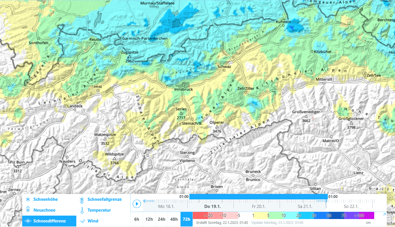
The snowpack is highly varied throughout the land. This applies both to the snowpack surface; to the snowpack layering; and to the distribution. It is the consequence of extremely diverse weather conditions this winter. Currently it is also a function of the highly fluctuating degree to which snow depths have grown and to wind impact.


72h-Differenz der Schneehöhe
72-hr difference in snow depths


Windverteilung vom 22.01.2023 05:00 Uhr
Wind distribution on 22.01.2023, 5:00 am


Eine der neuschneereichen Wetterstationsstandorte. Puitegg/Gehrenspitze in den Mieminger Bergen. Der Schneestandort Puitegg scheint windberuhigt gewesen zu sein. Am Windstandort Gehrenspitze wehte hingegen kräftiger Nordostwind.
One of the measurement stations where snowfall was heaviest, Puitegg/Gehrenspitze in the Mieming Massif. The spot where the station is located seems to have been wind-protected. Whereas at the wind-measurement device on Gehrenspitze, strong velocity NE winds were blowing.


Teilweise griff der Wind auch bis in die Täler durch, wie hier in Virgen in Osttirol
In some places, like here in Virgen in Osttirol, winds extended down to the valley floor.


Auch interessant: Ca. 15mm Niederschlag während der vergangenen zwei Tage ergaben aufgrund der kalten Temperaturen knapp 50cm fluffigen Neuschnee. Station Wilde Krimml in der Region Westliche Kitzbüheler Alpen
 Fascinating: the 15mm of precipitation during the last two days resulted in less than 50cm of fluffy fresh snow due to the low temperatures. Station Wilde Krimml in the western Kitzbühel Alps


Freshly generated snowdrifts in steep terrain: AVOID THEM!


Hone your skills, sharpen your ability to recognize freshly generated snowdrifts on-site, and rigourously circumvent them in steep terrain. To an increasing degree, these avalanche prone locations are above the forested zones; however as we just pointed out, in some places the wind extended down to low lying areas. Danger zones can also lie in steep forest clearances at far lower altitude, for example.


Windeinfluss im Waldgrenzbereich. Hahnenkamm bei Reutte (Foto: 21.01.2023)
Wind impact at the edge of a forest. Hahnenkamm near Reutte (photo: 21.01.2023)


Hohe Störanfälligkeit der Schneedecke, dort wo kalter lockerer Pulverschnee von Triebschnee überlagert wurde. Bergeralm - Zentrale Stubaier Alpen (Foto: 21.01.2023)
High proneness to triggering wherever cold, loose powder snow has been covered by snowdrifts.
Bergeralm, central Stubai Alps (photo: 21.01.2023)


Windeinfluss auch in tiefen Lagen, wie hier im Gemeindegebiet von Matrei i.Osttirol (Foto: 21.01.2023)
Wind influence even in low lying areas like here inside town limits of Matrei in Osttirol (photo: 21.01.2023)


Persistent weak layer persists


To round out the last Blog: the snowdrift masses which accumulated due to heavy wind can constitute a slab in zones where the snowpack previously was loose / low in tension. Increasingly this was in shady terrain starting at about 2000-2200m. Also in sunny terrain, whenever a new slab forms, the likelihood of faceted layers bordering crusts triggering is heightened. This occurs particularly at altitudes starting at 2300-2500m.


Yes, superb powder descents are also possible!


Safe and Unsafe often lie right next to each other. What matters here is experience in assessing avalanche dangers on-site. That’s how to distinguish safe from unsafe zones. Then, fabulous powder descents are on the agenda.


Unterwegs in den Westlichen Kitzbüheler Alpen (Foto: 21.01.2023)
Swishing in the western Kitzbühel Alps (photo: 21.01.2023)