Increasingly dangerous, accident-prone avalanche situation, especially for winter sports enthusiasts
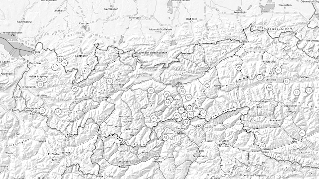
To start off: during the next few days, an extremely serious and dangerous situation will develop regionally for winter sports enthusiasts. Starting tomorrow, Friday 02.02, in the eastern regions of Tirol, high avalanche danger will prevail above the timberline. Naturally triggered avalanches are to be expected, most of them medium-sized. However on Friday evening, also large-sized avalanches (Lawinengröße 3) will be increasingly frequent. In open terrain starting at the timberline, the likelihood is high that winter sports enthusiasts can trigger slab avalanches on steep slopes. Caution urged also in sparsely wooded zones. Even remote triggerings are possible from flat stretches. During the next few days, the likelihood of remote triggerings will tend to increase.
 |
| Avalanche danger map for Friday, 03.02.2023. In Tirol’s eastern regions, frequently high avalanche danger |
Lots of fresh snow and stormy conditions
We are facing a tense NW weather front. Three bouts of precipitation will bring us up to 100 cm of fresh snow starting today, Thursday, 02.02, until Monday, 06.02.2023 amid storm-strength winds. The major areas of precipitation focus on northern and eastern regions. Immense differences in amounts of fresh fallen snow over small spaces are possible.
 |
| 72 hr-fresh snow forecast 02.02.-05.02. at 1:00 am |
 |
| On Friday evening, 03.02, as the next round moves in, winds will accelerate to their highest speeds: storm! |
Weak snowpack
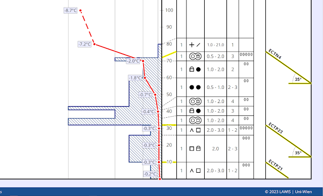
The snowpack frequently consists of numerous layers with huge differences in hardness. Crusts inside the old snowpack were increasingly “dissolved” i.e. became thinner last week, making the overall assembly of layers looser. Weak layers consist largely of expansively metamorphosed (faceted) crystals. Near the surface there is also surface hoar in wind-protected zones, in isolated cases super-light fluff and, most recently, lots of graupel. Let’s have a look at a few snow profile examples:
A few impressions of the surface-near weak layers follow. The surface hoar which was frequently observed over the last two weeks was often dissolved by the strong winds of recent days. Nevertheless, there are areas where this did not happen, to an increasing extent in shady, sparsely wooded zones in forests or in wind-protected, shady, leeward bowls at the foot of cliffs.
.jpg) |
| Surface hoar on Bleinse Berg on Serleskamm. photo: 30.01.2023 |
 |
| The circles on the map symbolize reports of surface hoar during the last 2 weeks. |
Formation of surface hoar was reinforced by fog which was prevalent from 26-29 January. The ceiling often lay between 1700 and 1900 m, but in some places (Samnaun Massif, Zillertal Alps) it extended up to 2700 m at times.
(1).jpg) |
| Persistent high fogbanks over Inn Valley on 26.01.2023. |
.jpg) |
| Numerous reports of graupel came in from every corner of the land today (02.02). Massive graupel deposits can also generate weak layers for slab avalanches. Weisskugel Massif. |
.jpg) |
| Snowdrifts and fluff have been highly triggerable of late. Glockner Massif (photo: 29.01.2023) |
_bearbeitet.png) |
| Glide cracks appearing when someone treads freshly generated snowdrift accumulations. Due to the low slope gradient, the slab didn’t release. Weisskugel Massif (photo: 31.01.2023) |
Recent avalanches
Over the last few days there have been increasingly frequent reports of small-to-medium sized avalanches, a confirmation that the snowpack is highly prone to triggering.
_bearbeitet.jpg) |
| Small ridgeline slab avalanche below Mugkogel in Kühtai. (photo: 31.01.2023) |
_bearbeitet.png) |
| Avalanche triggered by a chamois (arrows show its track into the avalanche and out of it again). Sellrain (photo: 01.02.2023) |
_bearbeitet.jpg) |
| Naturally triggered slab avalanche at 2500m SSW in the Gurgler Massif. Fresh snowdrifts were the additional weight. (photo: 01.02.2023) |
What’s coming? Danger for winter sports enthusiasts - Highly exposed roads can be at risk
As mentioned at the outset, all the prerequisites exist for a situation which, at very least for winter sports enthusiasts, is highly dangerous over the next few days: a weak snowpack, snowfall accompanied by strong-to-stormy winds, plus tomorrow (Friday, 03.02.2023) a brief interim of improved conditions including solar radiation and a slight rise in temperatures. This last part enhances the formation of a slab, which in turn raises proneness to triggering. ATTENTION: tomorrow’s brief interim of fine weather following fresh snowfall and strong winds will be highly accident-prone!
As a result of the additional rounds of precipitation starting on Friday, we also expect increasingly frequent naturally triggered avalanches, also large-sized releases, starting in the late evening. At low and intermediate altitudes, increasingly frequent glide-snow avalanches are likely on steep grass-covered slopes. Subsequently, glide-snow avalanches can endanger certain access roads to homes. Caution is urged near exposed starting zones due to possible naturally-triggered slab avalanche releases.
Important: due to a winter which thus far has been low in snowfall, naturally triggered avalanches do not have as much snow in their plummet paths to sweep away. For that reason, their magnitude will be limited.
 |
| Snowfall and storm winds have made avalanche danger levels rise to HIGH in some regions. Station Sonntagsköpfl in the eastern Tux Alps |


.jpg)
_bearbeitet.png)