In short:
The lack of precipitation this winter is quite striking in the snow cover. For this juncture of the season there is much too little snow on the ground, not only here in Tirol but in far-reaching parts of the Alps. See also the Blog of our colleagues in Switzerland.
Avalanche danger levels are moderate, particularly on the Main Alpine Ridge and a little north of there above about 2200m. That is because of isolated avalanche prone locations where winter sports enthusiasts can still trigger releases. Please refer to our last Blog.
On the weekend some fresh snow will be added to it. Avalanche danger will increase somewhat from region to region. Above the timberline, approximately, freshly generated snowdrift accumulations require caution.
(Much too) little snow
For the next few days, a bit of snowfall is in view but that does not much change the overall snow picture, i.e. dearth of snow. The puny snow depths can most easily be appreciated in a comparison of wetcam photos and with long-term records of our observers:
 |
| The graph shows snow depths measured by observers on the Northern Massif since 1973. Upper border: maxima till now. Lower border: minima till now. Gray line: medium value. Line in magenta: snow depths this winter |
 |
| Snow depths on the Seegrube above Innsbruck looking towards Wipptal (22.02.2023) |
 |
| For comparison, a photo from 21.02.2019 |
.jpg) |
Similar pictures throughout Tirol: on sunny slopes, hardly a cohesive snowpack up to high altitudes.
(photo: 21.02.2023; (c) Stefan Zangerl) |
.jpg) |
| A lack of snow is also noticeable on the glaciers, where a very high danger of falling into crevices threatens for this juncture of the season. Gurgler Massif (Foto: 21.02.2023) |
Persistent weak layer in isolated places, esp. near ridgelines on very steep shady slopes
In the interim, quite favourable conditions reign, as far as avalanche danger is concerned. However, there are still isolated danger zones where slab avalanches can be triggered. These spots are found especially on very steep shady ridgeline slopes above about 2200m. Avalanches can be triggered especially wherever there have been only few winter sports enthusiasts this year, and in transition zones from shallow to deep snow. For further details, please consult our last
Blog.
 |
Snow profile near a recent slab avalanche triggered by a winter sports enthusiast in northern Zillertal Alps.
Persistent weak layer. (21.02.2023) |
Outlook: fresh snowfall will lead to a small snowdrift problem
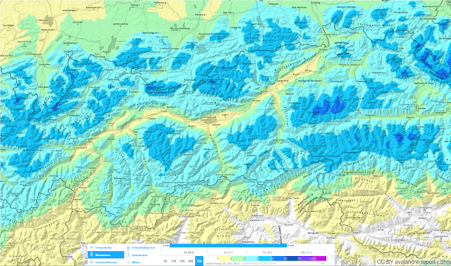
Geosphere Austria weather service forecasts snowfall in the next few days. In general, about 20cm is expected at high altitudes, up to 40cm from place to place. The snowfall will be accompanied by strong-velocity winds, mostly from the west.
 |
| 72-hr fresh snow forecast 24.02.-26.02.2023 |
This will lead to a generally minor snowdrift problem above the timberline, which could be somewhat more pronounced in the major areas of precipitation. Caution urged in wind-protected, very steep slopes behind abrupt discontinuities in the terrain.
Fresh snow and freshly generated snowdrifts will be deposited atop a highly diversified snowpack surface:
- melt-freeze crusts which are more or less capable of bearing loads on steep sunny slopes and shady slopes up to intermediate altitudes;
- knobby powder in wind-protected shady terrain and at high altitudes in wind-protected flat terrain
- snowpack surfaces which were recently hit by wet-snow slides
- snowpack surfaces showing high wind impact at high altitudes
Fresh snow and snowdrifts are expected to bond quite well with the old snowpack. The bonding is least favourable of all, by comparison, where there was knobby powder up to the time of precipitation.
.jpg) |
| Melt-freeze crust capable of bearing loads in sunny terrain, Alpeiner mountains (photo: 16.02.2023) |
.jpg) |
| Knobby powder in the Silvretta (photo: 21.02.2023) |
.jpg) |
Snowpack surface showing impact from a small wet-snow slide. Eastern Karwendel
(photo: 22.02.2023) |
.jpg) |
| As the photographer so aptly put it: Winds last weekend were blowing at “above rock-transport velocity.” Region Sellrain-Alpeiner mountains (photo: 19.02.2023) |
 |
| Measurement station Nachtweide - Palinkopf in the Silvretta: it was windy last weekend. Friday, 17.02 and Saturday, 18.02, still a thoroughly wet snowpack and thus, heightened wet-snow activity. All in all, variable conditions with sunny intervals, temperatures receding only slowly. |
 |
| Precipitation and wind forecasts including changes in snowfall level for the major region of precipitation, central Kitzbühel Alps. |
 |
| Temperature forecast for coming days. It will get colder, but temperatures will rise again starting next week. |
For a brief spell: loose-snow avalanches right after the snowfall
When the forecast snowfall comes to an end and solar radiation returns, numerous loose-snow avalanches can be expected on extremely steep slopes. In very isolated cases, small naturally triggered slab avalanches are conceiveable in the major areas of precipitation, particularly on very steep slopes where there are freshly generated snowdrift accumulations plus massive solar radiation with higher daytime temperatures. Those moments of danger are expected to arrive...and then swiftly depart.


.jpg)
.jpg)


.jpg)
.jpg)
.jpg)
.jpg)


