Ongoing quite favorable conditions, slight daytime increase in danger
The big message: currently (28.04) there are very few avalanche problems. Loose-snow avalanches on extremely steep slopes and small fresh snowdrifts in high-alpine shady terrain are the main dangers. During the course of the day the snowpack surface softens on sunny slopes and loses some of its firmness.
.jpg) |
| Loose-snow slides in extremely steep terrain. Stubai glacier. (photo: 28.04.2022) |
Weather review
Last week did honor to the month of April. Repeated bouts of precipitation, often strong-velocity winds from varying directions, rather cool for this juncture of the season. Starting on 27.04 weather conditions improved. Very dry air.
 |
| Variable: as of 27.04. improved weather conditions. Pitztaler Gletscher |
 |
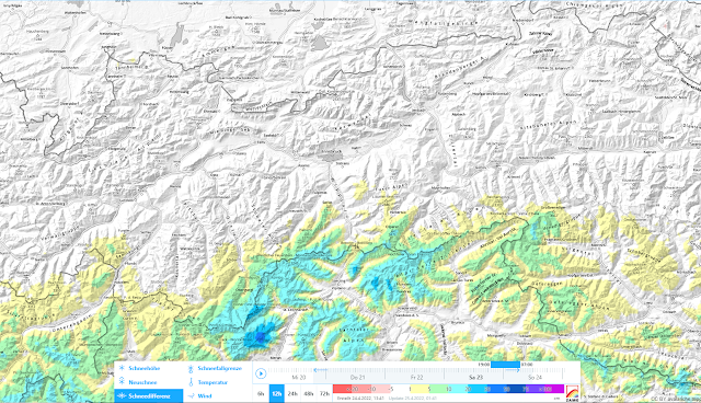
| 12hr-snow depth difference 23.04. - 24.04.2022 |
 |
| The hot spot of precipitation on 24.04 was at the Timmelsjoch station in the Gurgler Massif. |
 |
| More precipitation on 24.04-25.04 |
Powder snow and firn
There was a brief spell when superb powder and good firn was enjoyed, in some places immediately following on the heels of the other). Due to the dry air that might be true tomorrow, 29.04. Thereafter the powder will be blanketed by a crust also in high alpine terrain.
.jpg) |
| Powder snow at 3000 m in the Stubai Alps (photo: 28.04.2022) |
.jpg) |
| A photo from the 18.04 “archives.” Great firn in the Zillertal Alps, still to be enjoyed on steep sunny slopes. |
A glance beneath the snowpack
As mentioned before, we are currently concentrating on the potential near-surface weak layers which have formed over the last few days due to dp.4. This means high alpine shady terrain. Due to only minor amounts of recent snowfall (usually 10-20 cm) and based on reports and snowpack analysis, we assume the problems are quite isolated. Caution urged in immediate ridgeline, extremely steep high alpine terrain. The risks of taking a fall are higher than those of being buried in snow masses.
.png) |
| At 3040m, NE, Stubai Alps, only partial fractures could be generated near the crusts. Weak layers were not sufficiently pronounced to become a danger. (photo: 28.04.2022) |
The poorest snow quality is currently to be found in shady terrain at 2300m. There the snowpack is thoroughly wet down to lower layers. That is where you break through most easily.
 |
| Isotherm snow profile at 2260m in the Silvretta from 26.04.2022 |
On 30.04 our last Avalanche Bulletin of the season (with forecast for 1 May) will be published. Blogs will be published whenever the snow and avalanche situation changes significantly.
.jpg) |
| Spring is here... (photo: 20.04.2022) |
We thank all of you enormously for the numerous, valuable reports.
.jpg)
