Conditions: variable!
The first week of April has been highly variable. To start with, formidable amounts of snow with little wind, but strong where there was impact. All this at low temperatures. Subsequently less and less sunshine, with rainfall up to 2000 m, particularly in North Tirol. Rising temperatures.
.jpg) |
You had your work cut out for you when laying a track last weekend. Rieserferner Massif
(photo: 02.04.2022) |
 |
| 72-hr snow depth difference, 03.04.2022. Up to 50 cm of snowfall in some high altitude places. |
.jpg) |
Powder Alarm in the Tux Alps. In extremely steep terrain, loose-snow avalanches could be easily triggered in regions where there was lots of fresh snow. Sluff Management was the word of the day.
(photo: 03.04.2022) |
 |
| Initially quite cold, then increasingly warmer. Repeated bouts of precipitation, starting 07.04 at latest strong wind impact in the mountains. |
 |
| One of the few really windy spots on 03.04. (southern East Tirol) |
No serious avalanche problems
Loose-snow avalanches
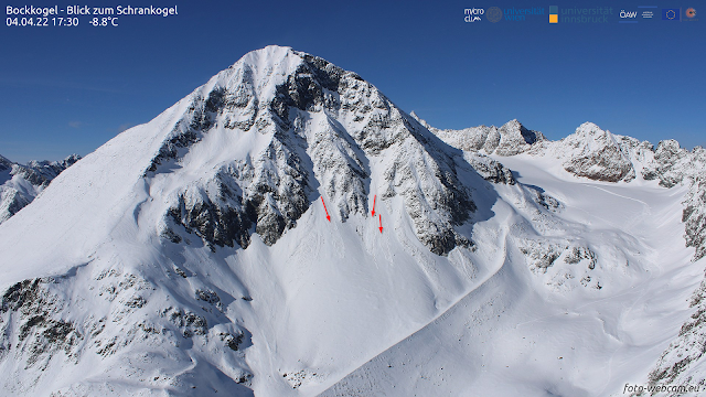
The main danger was loose-snow avalanches immediately following snowfall. Diffuse solar radiation was just as responsible as impulses from winter sports enthusiasts. The releases were mostly small, sometimes medium-sized.
_bearbeitet.png) |
| Loose-snow avalanches on Carnic ridge (photo: 06.04.2022) |
 |
| Loose-snow avalanches on Schrankogel in the Stubai Alps (photo: 04.04.2022) |
.jpg) |
| A loose-snow avalanche triggered by a winter sports enthusiast (photo: 04.04.2022) |
Glide-snow slides and avalanches in regions where snowfall was heavy
Wherever snow fell on steep bare grass-covered slopes, there were increasingly frequent glide-snow slides, in isolated cases large-sized. In the interim, such activity has receded.
(.jpg) |
| Gliding snow on grass-covered slopes. Tux Alps (photo: 02.04.2022) |
(Small) snowdrift problem at high altitudes
In spite of strong winds starting on 07.04.2022 it can be assumed that the transported snow was a problem only at very high altitudes. In any case, the likelihood of these snowdrift accumulations triggering increased with altitude. Potential weak layer: probably the graupel which was deposited during showers in North Tirol on 06.04. And in high alpine regions, also the loose fresh snow (on 07.04) could form a weak layer. Avalanche prone locations occur particularly behind protuberances in very steep terrain. A possible development that we also kept an eye on: Danger Pattern “cold on warm” (dp.4). Starting on 31.03, a possible weak layer might have formed between the formerly moist old snowpack surface and the cold fresh fallen snow in a certain altitude and aspect belt. However, no worrisome developments of this nature have been recorded to date.
.jpg) |
| Snow transport at 3000m and above. Stubai Alps |
.jpg) |
| Just beneath the surface in some places: a pronounced layer of graupel. Stubai Alps (photo: 07.04.2022) |
.jpg) |
Over small spaces, snowdrift accumulations atop graupel could be triggered. Stubai Glacier
(photo: 07.04.2022)
What’s the outlook?
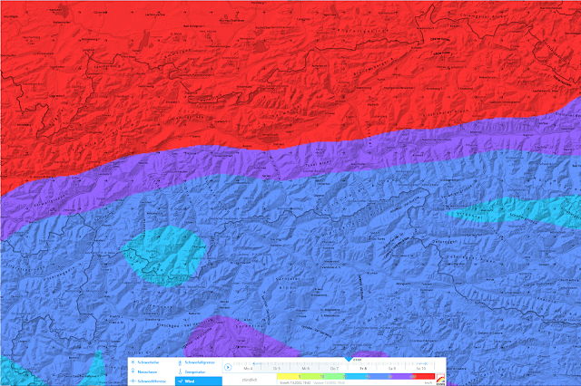
The ZAMG Weather Service forecasts for Friday, 08.04, and Saturday, 09.04, ongoing variably cloudy skies including precipitation. Temperatures are expected to drop. Initially the snowfall level will descend from 2000 m to below 1000m. What is striking: strong-to-stormy winds in the mountains will persist. The snowdrift problem will be at the forefront, requiring attentiveness at high altitudes in particular. In addition, following snowfall and diffuse solar radiation, loose-snow avalanches can again be expected on extremely steep slopes.
|
 |
| Storm-strength winds in the mountains. Stronger in the north than in the south... |
 |
72-hr fresh snow forecast, as of 07.04.2022
|
.jpg)


_bearbeitet.png)

.jpg)
.jpg)
.jpg)


.jpg)
(.jpg)
.jpg)