Friday, 8 October 2021

Winter Greetings in high alpine regions – Time to sharpen your sense of winter dangers

Cold front brings snow to high alpine regions

Following stormy bouts with a southerly foehn wind, then a cold front, it turned wintery along the Main Alpine Ridge in Tirol. Between 04.10 and 07.10.2021, measurement stations registered generally between 20 and 80 mm of precipitation, in some cases more than 100 mm. However, due to initially above average temperatures, about half of that precipitation fell in the form of rain, ultimately resulting in about 40 cm of fresh snow currently in the hotspots. Those hotspots are the zone between southern Ötztal and Stubai Alps and western Zillertal Alps along the Main Alpine Ridge.


72h-Differenz der Schneehöhe 05.10.-08.10.2022
72-hour difference in snow depth, 5-8 October 2022


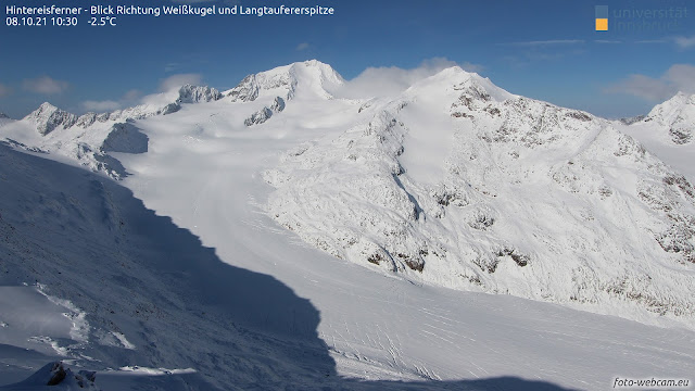
Nach der Kaltfront mit Schneefall reißt es nun auf. Blick Richtung Weißkugel. Interessant v.a. die Spalten am Hintereisferner, die großteils noch gut sichtbar sind, vereinzelt - zumindest kleine davon - aber auch schon von Neuschnee überweht sein können.
After the cold front unloaded the snowfall, skies cleared. View towards Weisskugel. Noteworthy are the crevices on the Hintereisferner Glacier which are still clearly visible for the most part, in isolated cases blanketed with fresh snowfall (small crevices, at least).


Avalanches: not yet a big problem

Currently we assume that avalanches will be only a minor problem as a result of this round of fresh snowfall. At the focal point in the immediate future: small-sized loose-snow avalanches in rock-studded terrain in high alpine regions, particularly today (8 October) as soon as the sun comes out.

In high alpine regions, i.e. above approximately 3000 m, in shady very steep terrain where the old snow fields remained intact over the summer, and also where the snow from late August and mid-September did not melt, small-sized snowdrift accumulations might still be triggerable. However, this scenario will be the exception, not the rule. Moreover, the threat will be quite short lived. In a potential avalanche, the dangers of being forced to take a fall far outweigh other perils.


Time to brush up your sense of wintertime dangers

Nevertheless, the time is now starting when your sense of potential avalanche dangers and other alpine threats needs to be sharpened, e.g. the early-winter peril of falling into a crevice or striking against stones with your skis. After all, this is the season when the first, frequently quite unexpected accidents occur. An example of such an early winter mishap can be found here.

Currently, we do not have detailed information about the structure of the snowpack, i.e. layering in the old snowpack still present in glaciated terrain. But we assume that next to no weak layers have formed. We base this assumption on the weather conditions since late August and empirical re-visualizations of the processes which habitually unfold. For example, here is a brief reference:
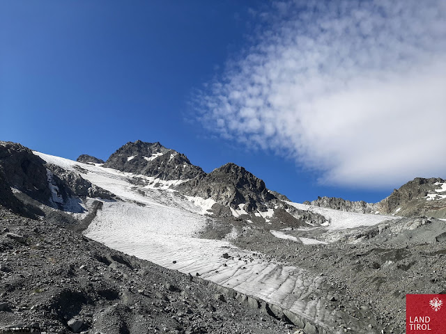

Der Gletscherrückgang hält an. Einige Altschneefelder vom vergangenen Winter. Hinteres Jamtal (Foto: 26.08.2021)
Glaciers are still receding. Some old snowfields from last winter. Rear Jamtal  (photo: 26.08.2021)


Wetterverlauf am Beispiel der Station Pitztaler Gletscher: Relevante Schneefälle gabs v.a. Ende August, um den 20.09. und während der vergangenen Tage. Am meisten Schnee fiel Ende August mit Spitzenwerten von knapp 100cm Neuschnee entlang des Alpenhauptkammes v.a. in Osttirol.
Weather development seen in the example of the Pitztal Glacier station: relevant snowfall occurred mostly in late August, around 20 September, and over the last few days. Most fresh snow was registered in late August: just under 100 cm of fresh snow along the Main Alpine Ridge, particularly in East Tirol.


Valsertal in den Zillertaler Alpen: Zusammenhängende Altschneefelder samt Schneeresten seit Ende August nur im Bereich von Gletscherresten bzw. Lawinenablagerungen vom vergangenen Winter.
Valsertal in the Zillertal Alps: cohesive area-wide old snowpack including residual snow from late August occurs only near residual glacial snow or avalanche deposits from last winter. (photo: 01.10.2021)


What matters now – and not only for us avalanche forecasters – is to come to grips anew with this fascinating material called snow. Particularly right now in early winter, stark temperature disparities often prevail both inside and outside the snowpack (including high-altitude rainfall which transforms to snowfall). Temperature extremes reinforce transformation, and in the course of those processes weak layers can form. If snowfall subsequently falls on top of that (frequently with wind influence) the mixture can unleash the first slab avalanches of the season.

The next edition of this blog will be published whenever serious changes occur in the snow or avalanche situation in the mountains of Tirol. Until then, enjoy a wonderful, accident-free time in the mountains!