Heads up: winter sports participants can trigger slab avalanches in high alpine regions! Problem zones are above approximately 2800 m.
Up to a metre of fresh snow
The onset of winter in Tirol’s mountains arrived in two thrusts: on 1-2 November and on 3-4 November, bringing up to 100 cm of fresh snow in places, already leading to a remarkable increase in avalanche danger for winter sports enthusiasts.
") |
| 24-hr fresh snow from first bout of precipitation (01.11. to 02.11.2021) |
") |
| 24-hr fresh snow from second bout of precipitation (03.11. to 04.11.2021) |
Weak snow cover in some regions
In high alpine regions, more than anywhere else in the regions along the Main Alpine Ridge, the fresh snow was deposited on top of a fragile old snowpack in some places. Weak layers are to be found in the vicinity of ground level and are often lodged between thin crusts (“crust sandwich”). Problem zones are above approximately 2800 m, at our present stage of knowledge. That means, to begin with, in shady steep terrain. With increasing altitude, also other aspects are endangered, particularly southwest-to-north-to-southeast facing slopes. This is due to the pre-winter snow which fell and remained on the ground, then expansively metamorphosed (became faceted) during the period of beautiful weather in October.
 (Foto: 04.11.2021)") |
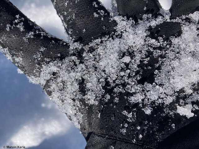
| Snow profile near Wurmkogel in the southern Ötztal Alps. Visible in the area near the glove is a loose layer near the ground. Above that, fresh snow was deposited which is well consolidated exept near the upper surface (winds slackened off noticeably towards the end of the snowfall.) (photo: 04.11.2021) |
 |
| Here the snow profile corresponding to the above photo: weak layers between thin crusts near ground level; atop that the “slab”; followed by loosely-packed, wind-impacted fresh snow. North, 2800 m |
 |
| Loosely-packed, faceted snow crystals were also found on the Hintertux Glacier near ground level at high altitudes. (photo: 21.10.2021) |
Caution: slab avalanches!
Already at the beginning of October following heavy bouts of snowfall the first slab avalanches of the season were observed. This occurred in the region of the Wildspitze in the Ötztal Alps.
") |
| Naturally triggered, shallow slab avalanches. 3200m, north Wildspitze (photo: 09.10.2021) |
") |
| Naturally triggered slab released near the ridgeline, Grossglockner. 3550m, E-SE (photo: 02.11.2021) |
") |
| A slab which was remotely triggered above the glacial ice on the Rettenbachferner in the Ötztal Alps. 2900m, north (photo: 04.11.2021) |
A wee bit treacherous: snowpack surface frequently loosely-packed.
Winds dissipated utterly towards the end of the last round of precipitation, as a result one currently “sees” very little wind impact at high altitudes. This makes for a deceptive impression, as if the whole snowpack were loosely-packed. Yet it isn’t! The reality is easy to recognize in the following weather station graph from the Stubai Glacier.
 |
| Storm-strength winds in some places on 3 November, subsequently slackening off significantly. |
Conclusion: restraint and experience are essential in outlying terrain
Winter sports enthusiasts who head into backcountry at high altitudes need to have ample experience in assessing avalanche dangers on-site and also to exercise great restraint. Apart from the peril of being buried in snow, there is possible danger of injury in early winter from stones jutting through the shallow snowpack.
In addition, caution urged on grass-covered slopes: glide-snow slides and glide-snow avalanches are possible.
Quite typical of early winter following periods of heavy snowfall are glide-snow avalanches on grassy slopes and loose-snow avalanches in extremely steep terrain. These types of avalanches were repeatedly observed during the last few days and this scenario will continue during the next few days, thereafter slowly diminishing. Particularly below grass-covered slopes where snowfall has been heavy, great caution is imperative. Here are a few photos...
") |
| Glide-snow slides and glide-snow avalanches in Defereggental (photo: 02.11.2021) |
") |
| Glide-snow slide on a dam in Axamer Lizum (photo: 04.11.2021) |
 |
Loose-snow avalanche in the Schlick (northern Stubai Alps) (photo: 03.11.2021)
|