Current situation
Avalanche danger has ongoingly decreased over the last few days. In the major areas of precipitation the snowpack has settled, fresh snow and drifts have bonded well with the old snow.
 |
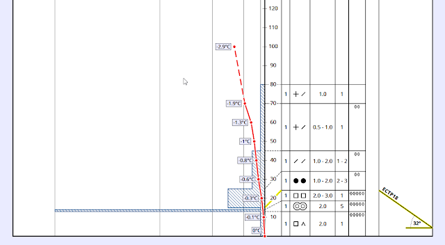
| Enormous settling of the snowpack since precipitation came to an end on Tuesday, 15.01. The graph shows a modelled settling. |
 |
| Also at Sonnbergalm measurement station in Sölden a noticeable settling of the snowpack can be observed. |
The major danger in most parts of North Tirol and northern East Tirol stems from generally small-sized but trigger-sensitive snowdrift accumulations. They occur in all aspects, particularly adjacent to ridgelines. Avalanche prone locations tend to increase in frequency and size with ascending altitude. The older snowdrift accumulations which were generated during the last snowstorm (13-15 January) and were often deposited on top of the light, fluffy snow of 12 January are no longer likely to trigger as avalanches, at most on shady, wind-protected slopes, but more at high altitudes.
The situation in central East Tirol, on the other hand, north of the Drau and south of the Main Alpine Ridge is much more treacherous. The snowpack was relatively shallow after the snowfall early this week, the numerous weather fronts generally brought small amounts of snow. In some places there was rainfall up to above the timberline. Due to expansive metamorphism of the snow crystals, a weak old-snow fundament formed containing a sequence of melt-freeze crusts and loosely-bonded, faceted crystals. The 30 cm of fresh snow (more at high altitudes) from early this week was deposited on the old snowpack and have formed a so-called “slab” on the deeper-down weak layers. The weak old snow can be triggered even by minimum additional loading, and the avalanches can grow to large size. Even remote triggerings have been registered and continue to be possible. Avalanche prone locations are found in all aspects above about 1600 m. Caution is therefore necessary, due to the fresh snow and strong winds in the Lienz Dolomites. Even small snowdrifts can be dangerous.
 |
| Slab avalanche triggered by skiers on Gaishörndl in Innervillgraten. The avalanche fractured in the weak old snow. (photo: 15.01.2019) |
 |
| At the Mosesgipfel weather station in Innervillgraten the snowpack was quite shallow until the end of last week. Thus, huge temperature fluctuations inside the snowpack occurred which anhanced the formation of faceted crystals and weak layers. |
Similarly deposited but less acute is the old-snow problem in the central Stubai Alps and the Gurgler group. Also there, the snowpack was shallow for a long time. Deeper down in the snowpack were faceted, weak layers near melt-freeze crusts which were triggerable. Due to heavy coverage with fresh snow, triggerings are generally possible only with large additional loading. Shallow-snow zones are particularly unfavourable, however: weak layers are often weaker and less well covered. Therefore, triggering is more likely (hotspot).
 |
| Snow profile from Unterrainsalm in Obernberg on 14.01.2019; west, 1555m, 32°. Weak layers in the old snow are easily triggered in places. (© Esther Baum) |
Review
Due to a strong NW airstream, new, intensive weather fronts were brought to the Alps between Saturday 12.01 and Tuesday 15.01 from the Atlantic. Accompanied by strong-to-stormy winds, there was heavy snowfall in Tirol. Even in the Dolomites there was up to 20 cm of fresh snow registered. Huge amounts of snow fell on the Seegrube above Innsbruck: between Sunday morning 13.01 and Tuesday morning 15.01 there was 215 cm of fresh snow registered.
 |
| Most snowfall was registered in the Allgäu and Lechtal Alps, Karwendel, Wilder Kaiser, Kitzbühel Alps and Hohe Tauern. |
 |
| The precipitation was accompanied by strong-to-stormy NW winds. |
 |
| The snowfall to date this year is historically unusual. At the southern portal to the Felbertauern there has never yet been such a deep snowpack since the beginning of measuring in 1990. |
On Monday, 14.01, due to the huge amounts of snow, high intensity of precipitation and persistently strong winds, numerous large-to-very-large, in isolated cases even extremely large avalanches were expected. For that reaons, the highest danger level (5, very high) was assigned in western regions of North Tirol, in the Zillertal Alps, Venediger Group and in the Karwendel (see
Blog).
Numerous reports as well as the results of exploratory flights over the mountains on Tuesday, 15.01, showed high avalanche activity. Many large and very large natural triggerings of slab avalanches were registered, particularly often in the Karwendel, Mieming Massif, Pitztal and Paznauntal. Also in Gschnitztal and in northern East Tirol, avalanches plummeted down to the valley floor. Some of them caused damage to forests, electric lines and building. No human casualties occurred. An important theme during this heavy snowfall was glide-snow avalanches, whose trigger-sensitivity was enhanced still further by rain impact up to 1500 m. Repeatedly, sectors of roads were displaced, also buildings were damaged.
It was only through the uninterrupted emergency service of many people on duty that the safety of the population could be ensured through this extraordinary period of bad weather.
 |
| High glide-snow activity in far-reaching parts of Tirol, e.g. here in the Wildschönau. (photo: 14.01.2019) |
 |
| Natural gliding of a glide-snow avalanche in Navis. Glide-snow avalanches can’t be artificially triggered. Therefore, safety authorities are often confronted with big problems. (photo: 14.01.2019) |
 |
| An avalanche in Aurach near Kitzbühel swept some forest along with it. This was a glide-snow avalanche. (photo: 15.01.2019) |
 |
| Glide-snow avalanches and fracture of a slab avalanche in Ausserfern. (photo: 16.01.2019) |
 |
| Glide-snow avalanches already covered by fresh snow, near Leermoos in Ammer range. (photo: 15.01.2019) |
 |
| Deposit of a huge slab avalanche below the Kleinen Zunig on the Felbertauern road between Huben and Matrei. (photo: 16.01.2019) |
 |
| An alm hut which suffered damages from a slab in Niltal near Virgen in East Tirol. In the background, the destroyed lift station at the Bonn-Matreier Refuge. (photo: 16.01.2019) |
 |
| Large naturally triggered slab avalanche at the Bschlaber Kreuzspitze in the Lechtal Alps. (photo: 15.01.2019) |
 |
| Avalanche near Piösmes in Pitztal. (photo: 16.01.2019) |
 |
| Fracture area of an artificially triggered slab avalanche above the glacier road to the Stubai Glacier ski area. (photo: 2016.01.2019) |
 |
| Fracture of a large naturally triggering slab avalanche on Hochwanner in the Mieming Massif. Many slab avalanches fractured near to ridgelines in very steep terrain. (photo: 16.01.2019) |
 |
| Snow fences support the snow masses and prevent avalanches from fracturing. Paznauntal. (photo: 16.01.2019) |
 |
| Rain at low altitudes left its marks on the snowpack. (photo: 16.01.2019) |
Outlook
On Thursday night (17.01) a cold front from the southwest will reach us and bring light snowfall and swiftly dropping temperatures. Most of the snow is anticipated in the Hohe Tauern and Zillertal Alps.
 |
| On Thursday night (17.01) we expect a small amount of snowfall throughout the land. |
The weather over the coming few days will be a mixture of sunshine and clouds, with light to moderate winds. The fresh snowdrift accumulations generated by winds on 18.01 will be quite prone to triggering to start with (reports already in from the central Stubai Alps).
The greatest caution is currently urged in the regions with the most striking old-snow problem (central East Tirol, Lienz Dolomites, regions of the central Stubai Alps and Gurgler Group). We recommend a prudent route selection, maintaining distances between members of a group both during ascent and descent, and circumventing large slopes and wherever the snow is shallow. Particularly in East Tirol, there is heightened danger of remote triggering!


