In this blog, we want to cast a bit of light on this subject and clear up just why warning-regions are continually being altered. It will be seen that this actually heightens the value of the new Euregio Avalanche Bulletin in important ways.
Background
The objectives of this device in the Euregio Avalanche Bulletin were not just to enhance the cross-border character and multi-lingual accessibility. Far more, it was meant to raise the quality of previous warning bulletins of the three regions. The new avalanche forecast enables avalanche analysts to describe dangers in a specific area more precisely and more consistently.
In the past in Tirol, South Tirol and Trentino, various avalanche danger levels were assigned to individual regions, but the description of the dangers which prevailed and the snowpack layering were valid for the entire province. In the new avalanche bulletin, this had to change: varying danger situations from region to region need to be separated from each other, described and depicted separately, in order to provide a picture of the situation which was as precise and consistent as possible. In order to reflect the regional/spatial distinctions of the given avalanche situation as flexibly as possible, the borderlines need to be flexible and changeable. On the other hand, it is still necessary to retain easily grasped borderlines oriented to topographical borders such as mountain ranges, valleys, or national borders.
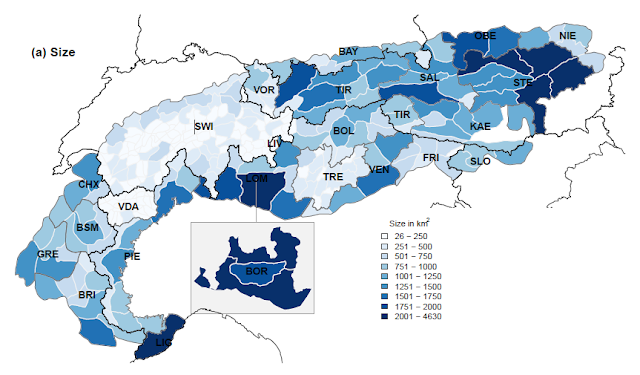
Ideally, the bulletin should cover clearly defined warning-regions which are as small as possible and which permit a precise message of avalanche danger and their variability over a limited area. This would prevent dangers in a given region from being ranked too high, or too low. The textual descriptions continue to be valid for the entire warning-region without specific distinctions made in the descriptions. A study by Frank Techel, avalanche forecaster and researcher of the WSL Institute for Snow and Avalanche Research at SLF in Davos from 2018 demonstrates that small regions improve the quality of avalanche forecasts.
 |
| Warning-region sizes in the Alps. The darker the color, the bigger the warning-region. (©Frank Techel, 2018) |
Until the end of winter season 2017/2018 the state of Tirol was sub-divided into 12 warning-regions; South Tirol into 11; Trentino into 21. While Trentino was already analyzing tiny regions with far smaller land surfaces in many cases, the warning-regions in South Tirol and Tirol were three times as large, on average.
Frequency and size of the tiny regions in South Tirol, Tirol and Trentino before and after the revamping to the new Avalanche Bulletin, starting with winter season 2018/2019:
State/ Province
|
Frequency
|
Size (min-max) [km²]
| ||
Season 17/18
|
Season 18/19
|
Season 17/18
|
Season 18/19
| |
South Tirol
|
11
|
20
|
650 (180- 1110)
|
345 (105 - 1500)
|
Tirol
|
12
|
29
|
980 (380- 1920)
|
295 (115 - 1105 )
|
Trentino
|
21
|
21
|
290 (120- 540)
|
290 (120- 540)
|
In the process of developing the Euregio Avalanche Bulletin, it was agreed to restructure the warning-regions in Tirol and in South Tirol. The object was to create tiny regions which were distinct from their immediate neighbors particularly with regard to precipitation. These tiny regions, it was agreed by the European Avalanche Warning Services (EAWS), should not be less than 100 km².
Based on the daily registered precipitation in various winters and with the support of a computer algorithm, zones of similar precipitation amounts, so-called clusters, were arrived at, with which, together with the input of the avalanche forecasters, new regions were created: in South Tirol, 20 new tiny regions were created; in Tirol, 29. These also permit overall reportage based on the old warning-regions.
 |
| Results of the cluster analysis of winter 2011/12 (left) and 2014/15 (right) for Tirol and South Tirol with the 29 / 20 new tiny regions. |
Avalanche warning
The avalanche forecasters in the Euregio South Tirol-Tirol-Trentino region now work with a multiplicity of tiny regions (70) which, depending on the given snow and avalanche danger situation, can be grouped together into larger warning-regions. During the course of the winter, the warning-regions are then re-grouped with areas where similar conditions and snowpack structure prevail. This provides a far clearer, more precise description of avalanche dangers. The experience of the last few weeks has shown that the overall Euregio region of 70 tiny regions was able to be grouped into 6-9 warning-regions on average.
Conclusion
This new approach to evaluating dangers permits avalanche forecasters to better communicate and describe the prevalent snow and avalanche situation, the threatening avalanche problems and the specific danger zones. We believe we have raised the quality of the avalanche forecast through this measure and we hope that readers see and understand, as well as gain benefits from the value of this enhanced value. It is a major adjustment, compared with the old avalanche bulletins and forecasts. Yet we are confident that readers will appreciate the clarity and precision of the new reports with time and be able to reap its many advantages.