Friday, 8 October 2021

Winter Greetings in high alpine regions – Time to sharpen your sense of winter dangers

Cold front brings snow to high alpine regions

Following stormy bouts with a southerly foehn wind, then a cold front, it turned wintery along the Main Alpine Ridge in Tirol. Between 04.10 and 07.10.2021, measurement stations registered generally between 20 and 80 mm of precipitation, in some cases more than 100 mm. However, due to initially above average temperatures, about half of that precipitation fell in the form of rain, ultimately resulting in about 40 cm of fresh snow currently in the hotspots. Those hotspots are the zone between southern Ötztal and Stubai Alps and western Zillertal Alps along the Main Alpine Ridge.


72h-Differenz der Schneehöhe 05.10.-08.10.2022
72-hour difference in snow depth, 5-8 October 2022


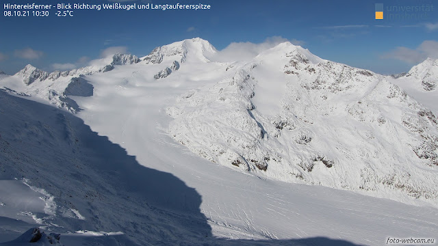
Nach der Kaltfront mit Schneefall reißt es nun auf. Blick Richtung Weißkugel. Interessant v.a. die Spalten am Hintereisferner, die großteils noch gut sichtbar sind, vereinzelt - zumindest kleine davon - aber auch schon von Neuschnee überweht sein können.
After the cold front unloaded the snowfall, skies cleared. View towards Weisskugel. Noteworthy are the crevices on the Hintereisferner Glacier which are still clearly visible for the most part, in isolated cases blanketed with fresh snowfall (small crevices, at least).


Avalanches: not yet a big problem

Currently we assume that avalanches will be only a minor problem as a result of this round of fresh snowfall. At the focal point in the immediate future: small-sized loose-snow avalanches in rock-studded terrain in high alpine regions, particularly today (8 October) as soon as the sun comes out.

In high alpine regions, i.e. above approximately 3000 m, in shady very steep terrain where the old snow fields remained intact over the summer, and also where the snow from late August and mid-September did not melt, small-sized snowdrift accumulations might still be triggerable. However, this scenario will be the exception, not the rule. Moreover, the threat will be quite short lived. In a potential avalanche, the dangers of being forced to take a fall far outweigh other perils.


Time to brush up your sense of wintertime dangers

Nevertheless, the time is now starting when your sense of potential avalanche dangers and other alpine threats needs to be sharpened, e.g. the early-winter peril of falling into a crevice or striking against stones with your skis. After all, this is the season when the first, frequently quite unexpected accidents occur. An example of such an early winter mishap can be found here.

Currently, we do not have detailed information about the structure of the snowpack, i.e. layering in the old snowpack still present in glaciated terrain. But we assume that next to no weak layers have formed. We base this assumption on the weather conditions since late August and empirical re-visualizations of the processes which habitually unfold. For example, here is a brief reference:
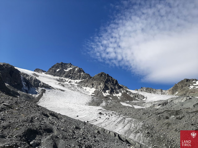

Der Gletscherrückgang hält an. Einige Altschneefelder vom vergangenen Winter. Hinteres Jamtal (Foto: 26.08.2021)
Glaciers are still receding. Some old snowfields from last winter. Rear Jamtal  (photo: 26.08.2021)


Wetterverlauf am Beispiel der Station Pitztaler Gletscher: Relevante Schneefälle gabs v.a. Ende August, um den 20.09. und während der vergangenen Tage. Am meisten Schnee fiel Ende August mit Spitzenwerten von knapp 100cm Neuschnee entlang des Alpenhauptkammes v.a. in Osttirol.
Weather development seen in the example of the Pitztal Glacier station: relevant snowfall occurred mostly in late August, around 20 September, and over the last few days. Most fresh snow was registered in late August: just under 100 cm of fresh snow along the Main Alpine Ridge, particularly in East Tirol.


Valsertal in den Zillertaler Alpen: Zusammenhängende Altschneefelder samt Schneeresten seit Ende August nur im Bereich von Gletscherresten bzw. Lawinenablagerungen vom vergangenen Winter.
Valsertal in the Zillertal Alps: cohesive area-wide old snowpack including residual snow from late August occurs only near residual glacial snow or avalanche deposits from last winter. (photo: 01.10.2021)


What matters now – and not only for us avalanche forecasters – is to come to grips anew with this fascinating material called snow. Particularly right now in early winter, stark temperature disparities often prevail both inside and outside the snowpack (including high-altitude rainfall which transforms to snowfall). Temperature extremes reinforce transformation, and in the course of those processes weak layers can form. If snowfall subsequently falls on top of that (frequently with wind influence) the mixture can unleash the first slab avalanches of the season.

The next edition of this blog will be published whenever serious changes occur in the snow or avalanche situation in the mountains of Tirol. Until then, enjoy a wonderful, accident-free time in the mountains!

Friday, 28 May 2021

Ongoing winter in high alpine regions • Avalanches still a concern

Coolest spring for at least 25 years - Still lots of snow in the mountains


The ZAMG Weather Service recently informed us that spring 2021 is the coolest we have had in the last quarter of a century at least. Similar temperatures prevailed for the last time in 1996 and 1991, a notch cooler still in 1987.

The results are plainly visible in the mountains: winter persists at high altitudes. Potential avalanche problems due to lower-than-average temperatures are still a worry, i.e. near-surface layers. Details can be found in our last blog. Most difficult of all to evaluate is the possible formation of danger pattern “cold-on-warm” (gm.4) and “embedded graupel” (gm.9). We currently assume that these danger patterns tend to be limited to high alpine regions (above 3000m). The greatest probability of dp.4 occurring is on sunny, very steep slopes.

What helps most of all to assess the current situation, in view of the lack of up-to-date snowpack data, are near-surface stability tests you carry out yourself on-site. 


A few photographic impressions of the current situation


Schneebrettlawine in der Großvenediger-Region auf ca. 3200m SW. Oberflächennaher Anriss. Gefahrenmuster gm.4 bzw. gm.9 als wahrscheinlichste Ursache. (Foto: 26.05.2021)
Slab avalanche in Grossvenediger region, appx. 3200m SW. Near-surface fracture, danger pattern dp.4 and dp.9 were the likely cause. (photo: 26.05.2021)


Ablagerung einer nicht mehr ganz frischen Schneebrettlawine in der Großvenediger-Region Nord 2600m. Kurzfristiger Wärmeeintrag als möglicher Auslöser (Foto: 21.05.2021)
Deposit of a no longer fresh slab avalanche in Grossvenediger region, N 2600m. Brief period of warmth as possible trigger mechanism. (photo: 21.05.2021)


Wohl am häufigsten zu beobachten und am vergleichsweise leichtesten einzuschätzen: Lockerschneelawinen unmittelbar nach Neuschneefällen. (Foto: 26.05.2021)
Surely the most frequent and easiest to assess: loose-snow avalanches right after snowfall.
(photo: 26.05.2021)


Lockerschneelawinen lösen sich meist spontan, lassen sich im extrem steilen Gelände aber auch sehr leicht durch Wintersportler auslösen. Nördliche Stubaier Alpen (Foto: 23.05.2021)
Loose-snow avalanches generally trigger naturally, but in extremely steep terrain they can easily be unleashed by winter sports enthusiasts. Northern Stubai Alps (photo: 23.05.2021) 


Frischer Triebschnee in großen Höhen. Aufgrund der kalten Temperaturen zumindest kurzfristig ein Thema, vermehrt in kammnahen, sehr steilen Hängen. Großvenediger-Region. (Foto: 26.05.2021)
Fresh snowdrifts at high altitude. Due to low temperatures a problem at least for a brief spell, particularly near ridgelines on very steep slopes. Grossvenediger region (photo: 26.05.2021)


Vorsicht vor Wechten. Interessant an diesem Foto u.a. auch eingelagerter Saharastaub (Foto: 21.05.2021)
Caution: cornice! Even here, the Sahara dust is clearly visible. (photo: 21.05.2021)


Imposante Lawinenablagerung samt aufwändiger Schneeräumung im nördlichen Osttirol (Foto: 26.05.2021)
Impressive avalanche deposits and snowplowing efforts in northern East Tirol (photo: 26.05.2021)


Kein alltäglicher Anblick für Ende Mai. Sattes grün in den Tälern, zum Teil noch tief winterlich auf den Bergen. Nördliche Stubaier Alpen (Foto: 21.05.2021)
Not an everyday snapshot at the end of May: lush green meadows below, deep winter above.
Northern Stubai Alps (photo: 21.05.2021)


Die Wetterstationsgrafik am Pitztaler Gletscher bestätigt unseren Wettereindruck: Sehr wechselhaft, auf den Bergen kalt, windig und viel Schnee.
Weather station graphs on Pitztal Glacier corroborate our own gut feeling:
highly variable, cold in the mountains, windy, lots of snow.


Weather remains variable - Avalanche danger still a concern


Today, Friday 28 May, is a shining exception to the recent norm: pleasant weather. However, the cool, variable conditions have not departed, they will be with us during the coming days.


Vergleichsweise viel Sonne gibt es nur heute am 28.05.2021... (c) ZAMG-Wetterdienststelle
Comparatively lots of sunshine, but only today, 28.05.2021... (c) ZAMG-Weather Service


And so...in spite of the advanced juncture of the season, attentiveness is still required towards potential avalanche danger in high alpine regions.


Update of this blog: (28.05.2021 - 07:00 Uhr):


The above information about the weather referred to yesterday’s report from ZAMG Weather Service. Today’s has not yet been published. Here is an excerpt from the last valid report of ZAMG Weather Service from 28 May 2021 at 7:00 am:


“Following in the wake of a cold front, intermediate high-pressure front weather conditions will be felt today in Tirol. On the weekend, a northerly air current and a high/low will move from the Baltic Sea towards Hungary. Tirol will receive moderately moist air which particularly in eastern regions will create cloudbanks. Further west, weak high-pressure conditions will prevail. Next week we will lie at the rim of a high-pressure front. Starting on Sunday, we expect several days of dry weather, culminating in early-summer temperatures next week.”

Thus, we anticipate classic springtime conditions and daytime fluctuations of avalanche danger.

The next update of the blog will be published whenever the avalanche situation undergoes a major change.

Thursday, 20 May 2021

Still wintery in high alpine regions – Avalanche danger requires attentiveness

 Regionally still lots of snow in the mountains


During a period of overly cool, highly variable weather, the snow depths in high alpine regions are still increasing. Very wintery conditions continue to reign there unchangingly. This coincides with the reports of ZAMG Weather Service: spring was this cool in 1996 and 1991.


Overall snow depths in Tirol (on 20.05.2021)


Month’s review on Pitztal Glacier. Easily recognized: very cool temperatures with frequent precipitation, often strong wind. The current overall snow depths over this last month measure a maximum.


Snow situation on 18.05.2021 in Tux Valley


For comparison, one year ago, on 18.05.2020


Snowscape on 07.05.2021 in Axamer Lizum


For comparison, a year ago, on 09.05.2020


Fresh snow on 15.05.2021 on Stubai Glacier


Avalanche danger still requires high attentiveness


Although we currently have little information about snowpack layering at high altitudes, we currently assume problems in near-surface layers. Among these:


  • Snowdrift problem: 
    • particularly in high alpine regions, mostly near ridgelines; especially during or immediately following precipitation
  • Fresh-snow problem: 
    • Graupel: We know of massive graupel deposits regionally in near-surface layers. A thick layer of graupel blanketed by snowdrifts can constitute a weak layer for slab avalanches.
    • Wet loose-snow avalanches right after or during snowfall due to (diffuse) solar radiation and rising temperatures. This problem also occurs at lower altitudes where there has been heavy snowfall.
  • Old-snow problem: 
    • A continuing sequence of fresh snow, cold, moistening snowpack due to (diffuse) solar radiation impact harbors a high potential for danger pattern “cold-on-warm” (dp.4). We assume that this problem prevails increasingly above 3000m in all aspects in the near-surface layers. It is a treacherous risk which is exceedingly difficult to evaluate. The only thing which helps to clarify the conundrum is a view inside the snowpack and stability test. Please see our last Blog


Numerous naturally triggered wet loose-snow avalanches in the Northern Massif above Innsbruck due to (diffuse) solar radiation. (photo: 20.05.2021)


Ground level weakening of the snowpack due to water seepage is currently not a problem (on 9 May the case for the last time). Then, isolated slab avalanches were observed on shady slopes at 2500-2700m.


Avalanche Riepenwand-Schlicker Seespitze in the northern Stubai Alps at about 2500m NW, presumably on 9 May 2021.


From our colleagues in South Tirol we were informed of an avalanche accident with fatality yesterday on the Königsspitze at 3700m. Information can be viewed here:.


Pentecost will be highly variable


Tomorrow, Friday, 21 May, a warm front will bring higher temperatures with cloudy air from the Atlantic. In the mountains it will often be stormy, particularly near the Main Alpine Ridge. On Saturday, 22 May, a cold front will follow on its heels. The snowfall level is expected to lie at 1600m. The focal point of precipitation will lie on the Main Ridge east of Ötztal. Up to 40 cm of fresh snow could fall from place to place. The air masses will remain instable and cool, i.e. conditions which we’re currently accustomed to: highly variable! For avalanche danger, see above.


 72-hr fresh-snow forecast


Illuminating views, assuring us that spring is coming, slowly but surely....


Tuesday, 11 May 2021

Foehn collapses – Fresh snow + wind ratchet up avalanche danger

 The winter just doesn’t want to stop...


Over the last few days, a strong southerly foehn wind was blowing in the mountains. Today (11.05) the foehn collapsed. In the southern regions, precipitation has set in. In the northern regions a cold front from the west will move in during the evening/nighttime hours.


Windspeeds reach nearly 150 km/hr on Patscherkofel


Map of precipitation 11.05, 15:00 h. In southern regions, precipitation has already set in. Hot spot currently: Timmelsjoch.


Rainfall was initially expected up to about 2500 m. The snowfall level will settle at about 1500 and 2000 m as a result of the cold front (lower in the north than in the south).


48-hr forecast of fresh snow


Avalanche danger rising


A bit of fresh snow, together with wind impact, will increase avalanche danger. We expect large-sized naturally triggered releases in high alpine regions where there was lots of snowfall. This forecast is based on current reports of a large-sized near-surface slab avalanche near the eastern Simonyspitze in the Venediger Massif, as well as our own considerations.


Naturally triggered avalanche on eastern Simonyspitze (photo: 09.05.2021)


We currently assume that in high alpine regions a near-surface weak layer has formed due to Danger Pattern “cold-on-warm” (dp.4). With appropriate additional loading from the fresh snow it can be expected that slabs can trigger naturally, including over larger surfaces. In addition, fresh snowdrift accumulations at high altitudes can be triggered for a brief period by winter sports enthusiasts (weak layer, possibly blanketed powder or graupel). Increasingly. such danger spots are found near ridgelines in very steep terrain.


Abruptly activated fresh snow, due to diffuse solar radiation


Fresh snow at this juncture of the season reacts extremely rapidly to warmth and solar radiation. On Thursday at latest, when clouds will begin to disperse from place to place, we expect swift loss of firmness of the fresh snow. On the one hand, due to the sudden impulse of warmth; but also through naturally triggered slab avalanches. Loosely-packed snow and slab-avalanches can, subsequently, even sweep along the entire thoroughly wet snowpack with them in their plummet path.


Naturally triggered slab avalanches from 10 May due to increasing wetness of the snowpack on shady slopes. Altitude: 2500 m.


Restraint. And experience.


Thus, we anticipate a situation in which winter sports enthusiasts have gathered ample experience, where defensive strategy is called for. In addition, caution below the starting zones and in steep avalanche prone areas near canalised avalanche plummet paths is urged. There, avalanches can plummet down to low altitudes and even endanger hiking trails and forest roads.

Sunday, 9 May 2021

Information on avalanche incidents on Saturday, 8 May 2021

On Saturday, 8 May, numerous winter sports enthusiasts took advantage of the fine weather and mostly favourable conditions to venture into outlying terrain. The snow cover in early morning was well frozen, except in high alpine regions. Wonderful firn snow could frequently be enjoyed on the descents. During the day, the uppermost part of the snowpack became thoroughly moist in some places, leading to small avalanches, most of which were loose-snow releases.

In high altitudes, however, an icy wind was blowing which generated wide-ranging snowdrift accumulations in ridgeline terrain. These drifts proved to be quite prone to triggering, the primary cause of the avalanche incidents which then occurred (presumably also causally combined with the Danger Pattern “cold-on-warm” {dp.4} and/or graupel {dp.9}).

Here is a brief listing of the reported avalanches:

9:30 am: Hinterer Brunnenkogel (Stubai Alps): 3300m, E/SE, no injuries 

9:55 am: Blockkogelferner (Ötztal Alps): appx. 3050, NE, no injuries

10:19 am: Böses Weibele (Schober Massif): appx. 3000m, NE, 2 persons w/airbags, no injuries

10:49 am: Tonigenkogel (Ridnaun Massif): appx. 2900m, E, slide, no injuries

11:32 am: Watzespitze (Kaunergrat): 3400m, E, 2 persons injured

11:36 am: Weisskugel (Weisskugel Massif): 3700m, E


Avalanche accident Watzespitze. The slab fractured near the ridgeline when 2 persons were ascending on foot. The circle pinpoints their ski depot. (photo: 08.05.2021)


Webcam overview of avalanche below the Weisskugel


Detail of avalanche below Weisskugel. Arrow points to several descending tracks. One person was caught by the slab and injured, brought to the hospital in Merano. (photo: 08.05.2021)


For Sunday, 9 May, extraordinarily warm weather is forecast. The danger of wet-snow avalanches will swiftly increase. The time window permitted for safe backcountry ventures is significantly smaller than on Saturday, 8 May. This is recognizable on current weather graphs.


The air is currently moister and warmer than at the same time on the previous day. The nocturnal outgoing radiation and snowpack cooling will be poorer in comparison.


Our tip: better to start very early, head high up, and be back at your point of departure as early as possible. Special caution necessary around ridgeline snowdrifts in particular, also potential weak near-surface layers (see Blog). We wish all mothers a Happy Mothers Day!