Thursday, 12 December 2019

Regionally wintery. Main danger: fresh snowdrifts above treeline

The generally favourable conditions have deteriorated since last week as a result of snowfall and wind impact. Regionally there has been considerable avalanche danger. In East Tirol, favourable conditions still reign, but are now receding as a result of wind and some fresh snow.

Weather review
Variable conditions. That is the best way to describe this last week in North Tirol, particularly in the western and northern regions, which got some fresh snow, which was heaviest on 9 and 10 December, when 20-40 cm, locally as much as 50 cm of fresh snow was registered. Along the Main Alpine Ridge there was about 15 cm, in East Tirol only a bit.


A strong, sometimes stormy wind was blowing from varying directions above the timberline.


Galzig weather station: indicative of the western and northern regions of North Tirol where recent snowfall has been heaviest. Upper graph: precipitation and fresh snow. Lower graph: temperatures drifting closer then further apart, and melting points, bear witness to the variable weather conditions. Windy.

Kals weather station: striking in East Tirol, esp. on 10.12. Strong winds.

Snowpack development
As is well known, weather conditions have immediate impact on the snowpack, and the snowpack determines avalanche danger. What counts in the current situation was the high-pressure zone until the weekend. At low temperatures and during nights of clear skies, the snow crystals near the snowpack surface transformed to loosely-packed, generally decomposed, faceted crystals. This is a serious weak layer for the snowdrifts deposited on top of it. The heightened proneness to triggering of the snowpack in these areas was corroborated by increased glide-cracks and also by generally small-sized avalanches.

Glide cracks indicate heightened trigger-sensitivity of the snowpack. High Zillertal (photo: 07.12.2019) 

On sunny slopes, on the other hand, the beginnings of an expansively metamorphosed (faceted) layer beneath the melt-freeze crusts on the surface have been observed above approximately 1900 m, even more above 2200 m. Stability tests currently show a still minor tendency towards fracture propagation. In any case, this is a process which needs to be watched attentively.

Here is a Video from the Arlberg region, recorded on 10.12.2019. During a stability test, a sensitive weak layer beneath a melt-freeze crust was consciously triggered, and subsequently, the fracture propagation observed.

Also indicative: at high altitudes (prior to recent snowfall) and also in the regions where there was little precipitation, an old snowpack surface manifesting high wind impact. Stubai Alps  (photo: 07.12.2019)
In the interim also a winter portrait: Kitzbühel Alps. But be careful: beneath the shallow snowpack, stones threaten.  (photo: 11.12.2019)

Avalanche danger development and avalanche activity

The longish period of low avalanche danger has passed for the moment.

In East Tirol, mostly (very) favourable conditions for winter sports enthusiasts prevailed over the weekend. Karlskopf (photo: 07.12.2019) 
Fresh snow and winds have ratcheted up avalanche danger levels to considerable, regionally in those areas where there was heavy snowfall. The main problem stems from freshly generated snowdrifts. This applies especially to shady terrain and steep slopes near ridgelines.
Snowdrift accumulations could be disturbed with startling ease. There were also small, naturally triggered slab avalanches, and remote triggerings, observers have reported.

Fresh slab, near a ridgeline on Geigenkamm (photo: 10.12.2019)

Gliding-snow activity continues to be minor. In the western regions where snowfall amounts are increasing these releases could increase somewhat, especially in case of further snowfall.

Ellipse: fresh glide-snow avalanche. Arrow: older glide-snow avalanches and glide cracks. Tux Alps. (photo: 12.12.2019)

Encircled: recently released glide-snow avalanche (photo:  08.12.2019)

During this last week, three avalanche releases involving persons have been reported. On 6 December a person was injured in shady ridgeline terrain on a descent from Nederkogel in the Ötztal Alps, swept along by a small slab. On the Seegrube above Innsbruck, two slab avalanches were triggered when winter sports enthusiasts descended in east-facing, very steep ridgeline terrain.


A slab avalanche remotely triggered by a ski-piste vehicle, in the Northern Massif (photo: 10.12.2019)

What’s next?

According to ZAMG Weather Service forecasts, the southerly wind will shift to westerly tomorrow (13.12) and intensify to strong-to-storm strength velocity. In the western regions, 10-15 cm of fresh snow is anticipated, 20 cm from place to place, decreasing to 5-10 cm further to the east. On 14 December a warm front will move over Tirol. In the mountains it will remain stormy. Major wind direction: westerly. Above about 1500 m, about 20 cm of fresh snow is expected.

The stormy conditions will ratchet up avalanche danger somewhat. Regions with considerable avalanche danger will be more widespread. Rainfall at low altitudes will have a detrimental effect on the snowpack in those regions where precipitation is heaviest. If precipitation is heavy, small, moist loose-snow slides are possible. In wind-protected and non-rain impacted regions, the conditions are generally more favourable.

The main danger still stems from freshly generated and, to some extent, older snowdrift accumulations. Caution is urged, most of all, in steep terrain near ridgelines, in gullies and in bowls, as well as behind protruberances in the landscape in general. Winter sports enthusiasts require experience in on-site assessment of avalanche dangers.

Thursday, 5 December 2019

Ongoingly favourable avalanche situation

The favourable avalanche situation in Tirol persists. Even the weak cold front which is expected to brush Tirol on 7 December will not change anything significantly through Sunday, 8 December. The intensifying wind at high altitudes might generate fresh, relatively small snowdrift masses. These will sometimes be relatively easy to trigger, but can be easily recognized by practiced backcountry skiers and freeriders.

Danger level map for Thursday, 5 December 2019. Avalanche danger is frequently low.

Stable snowpack over widespread areas

What is currently most striking is the big difference in snow depths between northern and southern regions of Tirol. In the north, generally little snow; in the south, snow depths are noticeably above-average for this juncture of the season.

Snow depth measurements of our observer Hansjörg Schneider in Obertilliach. To date, maximum, average and minimum depths, along with current depths...and measurements go back to 1961!

Our evaluation of danger is based on the structure of the snowpack. Examinations of the snowpack continue to show a stable snow cover over widespread areas without any pronounced weak layers.

Snowpack analysis below Pfaffenkogel in the Stubai Alps (photo: 28.11.2019) 

Snow profile at the location cited above, at 3110 m, northwest, 25 degrees. Lower base: glacial ice. On top of that, compact layers of old snow influenced by melting processes. The bonding of the layers is good. Atop that, a very compact snow mass from the heavy snowfall of mid-November 2019.

On very steep, sunny slopes there are frozen water channels inside the snowpack in some places. Rietzer Griesskogel, Stubai Alps. (photo: 03.12.2019)

Snow profile, Axamer Lizum, 2120m, W, 25 degrees. What is interesting is the currently loosely-packed, cold snowpack surface. Clear nights facilitate expansive metamorphosing of the snowpack surface. For future snowfall, this then becomes a potential weak layer.

At high altitudes the snowpack is frequently wind-impacted, and thereby, hard. The snowpack surface hardens through melting and refreezing, also at intermediate altitudes on very steep, sunny slopes. (photo: 25.11.2019)

Review of the last week

Snowfall in westernmost regions

Most striking was the snowfall on 29.11 and 30.11 in the furthermost western regions. Snowfall was heaviest in the Arlberg and Galzig regions, about 50 cm. Elsewhere, from the rear Paznaun Valley into the western Lechtal Alps, often between 20 and 30 cm of fresh snow, with swiftly decreasing amounts moving to the east.

On Galzig, 50 cm of fresh snow. Since then, continually diminishing snow depths as a result of dry winter weather since Tuesday, 3 December.

Little avalanche activity

As a result of the fresh snow and wind at high altitudes, small snowdrift accumulations were generated in the western regions.  For a brief period these were relatively easy to trigger. These accumulations were especially prevalent behind abrupt changes in the terrain.

Small slab avalanche on the way to Hohen Kopf above the Friedrichshafen Refuge. (photo: 30.11.2019)

Small slab on lee slope near ridgeline below a cornice, Pitztal. (photo: 30.11.2019)

Small loose-snow avalanche from rocky terrain in Lechtal. (photo: 30.11.2019) 

Glide-snow slide in rear Ötztal. (photo: 30.11.2019)

Old glide-snow fracture in East Tirol. (photo: 03.12.2019)

Gliding snow over smooth rock slabs in Stubai Alps. (photo: 26.11.2019)

Steep-slope enthusiasts are getting what they seek

The favourable avalanche situation is being enjoyed to the fullest  by steep-slope specialists in the regions of the south where snowfall has been heaviest. Snow from the heavy snowfall in mid-November “sticks” to the extremely steep snow base.

En route in the Lienz Dolomites. (photo: 27.11.2019)

Also in the Lienz Dolomites. (photo: 27.11.2019)

A good time for safety training

The perfect time for a safety check is at the launch of winter: equipment and functional safety training of avalanche backpacks, battery check of beacon, transceiver check, etc.

Avalanche beacon and shovel training on Stubai glacier with colleagues from South Tirol and Trentino. (25.11.20019)
Safety training in Zürs. (photo: 02.12.2019)

What’s next?

The situation looks quite good for the coming period. A favourable avalanche situation will persist.

The stress-free pleasures of backcountry ski tours. Caution urged towards rocks near the surface. (photo: 01.12.2019)

Impressions from Axamer Lizum on 03.12.2019: Video: Simon Rainer


More and more ski areas have opened. The low temperatures are being used to make artificial snow. Axamer Lizum. (photo: 03.12.2019)

Isolated avalanche prone locations exist, particularly where there are small snowdrift accumulations at high altitude, increasingly near ridgelines in relatively shady terrain. In addition, glide-snow avalanches are still possible in isolated cases, which can grow to large size in the regions of the south where snowfall has been heaviest. The ironclad rule is still valid: avoid all zones below glide cracks.

On Monday, 9 December, the ZAMG Weather Service forecasts a small amount of snowfall in the furthermost western regions. Presumably, avalanche danger will then increase. For details – as usual – consult the Avalanche Bulletin on 8 December at 5:00 pm.


Friday, 29 November 2019

Mostly favourable conditions – isolated glide-snow avalanches in regions where snowfall was heaviest. Fresh snowdrifts, esp.in the west.

Mostly favourable conditions

Numerous examinations of the snowpack and reports from observers corroborate the assessment: the avalanche situation is improving to an increasing degree. The snowpack is stable over widespread areas. Weak layers are found only in isolated cases, and then, they are near to the surface at very high altitudes in the immediate vicinity of ridgelines.


Typical snow profile in the regions where snowfall was heaviest: stable layering. Stubai Alps, 28.11.2019

Avalanche danger in Tirol corresponds to this: in some places still moderate danger in the southern regions or else low avalanche danger prevails.


Main danger: isolated glide-snow avalanches

What still requires the greatest caution are glide-snow avalanches, although they are being observed only seldom. We are also getting reports from our observers in East Tirol that glide-snow avalanches have ‘nearly halted.’ Nevertheless, we still advise avoiding all spots below glide cracks in the snowpack. The moment when glide-snow avalanches release is impossible to predict.

Impressive snow shapes generated by gliding snow. (photo: 25.11.2019)

Gliding snow waiting to unleash. Defereggental (photo: 22.11.2019)

Terrific launch of winter in the southern regions

Pictures, as we know, are worth more than 1000 words. There follow a few impressions of the current situation:

Awesome powder snow on the descent from Schöntalspitze in the Stubai Alps. (photo: 21.11.2019)

The joys of a Tux Alps descent in early winter. (photo: 21.11.2019)

Alone on the path to the Grossvenediger. (photo: 25.11.2019)

Outlook

The forecasts of the ZAMG Weather Service predict no significant changes in the avalanche situation.

Appendix to 29:11: Latest analysis by ZAMG Weather Service shows that in the furthermost western regions a cold front will bring as much as 50 cm of fresh snow from place to place (in general about 20 cm). In the regions where snowfall is heaviest, increased heed of freshly generated snowdrift accumulations in very steep terrain is required.


The snow is settling to an increasing degree, the snowpack is stabilising. Repeated bouts of precipitation, wind in some places. The coming days promise similar weather.

Message of the moment: enjoy the snow masses in the south!


Friday, 22 November 2019

Glide-snow avalanches are the main danger

Lots of snow in the south

Precipitation this last week has been unusual. The consequence: above average snow depths for this juncture of the season.

“A Winter Wonderland” at the Dolomiten Hut in the Lienz Dolomites. (Photo: 18.11.2019) 

At low and intermediate altitudes, massive rain impact on the snowpack. Stubai Alps (Photo: 20.11.2019)

The heavy snow burden caused much tree breakage and toppling. This danger is still a threat. In the photo: a recently toppled tree in southern East Tirol (Photo: 20.11.2019)

The snowfall was accompanied by storm-strength winds. Stubai Alps. (Photo: 18.11.2019)

The combination of heavy snowfall, stormy winds and rising temperatures led to numerous avalanches, culminating on Sunday, 17.11.2019. In the photo, avalanches over the snow sheds on the Felbertauern Road (Photo: 18.11.2019)

Avalanche danger diminishing

During the last few days, avalanche dangers have decreased incrementally. In the interim, generally moderate danger prevails in the regions where precipitation was heaviest; in the northern regions, low danger.

Main peril: gliding snow

Most caution is still needed towards glide-snow slides and glide-snow avalanches on steep, smooth surfaces. Most of the threat is on grass-covered slopes. However, also below house roofs there is a hidden risk of gliding snow masses.

During the last few days in the regions of Tirol where precipitation was heaviest, numerous glide-snow avalanches have released. Glockner region (Photo: 21.11.2019)

Snow masses gliding off a roof can endanger people. Southern East Tirol (Photo: 20.11.2019)

The snow glides...and malforms. Obertilliach (Photo: 20.11.2019)

The apogee of glide-snow avalanches has passed. Nevertheless, at very least where glide cracks have opened in the snowpack surface, snow can still glide away as a single mass. Therefore, we advise avoiding all spots below glide cracks in the snowpack. Caution is also urged on tours through narrow valley zones flanked by grass-covered slopes, including above the treeline (where the risk is not visible).

Snowpack layering is mostly stable. Caution esp. on shady, high-altitude slopes near ridgelines.

Our picture of current snowpack layering in the land is becoming ever sharper, thanks to explorations in outlying terrain and extremely good observer reports. Snowpack analysis results in the following:

The snow cover has settled increasingly over the last few days, and stabilized.

Snowpack analysis at 2100 m, NW in northern East Tirol. Compact snow cover without weak layers. (Photo: 21.11.2019)

Weak layers inside the snowpack are now found only at high altitudes, starting at about 2400 m. At those altitudes, it is important to distinguish between surface-level weak layers and ground-level weak layers.

Near to the surface there is powder, often wind-whipped. Due to the stronger winds at high altitude, these danger zones are ever more frequent. Caution urged esp. on very steep, shady slopes near ridgelines.

Snow profile below Hohe Bösring on the Carinthian Crest. Wind-impacted powder snow is the potentially weak layer. Here at 2310 m, only a partial fracture could be generated, a positive sign. But the likelihood of triggering tends to increase with ascending altitude.

Near the ground, particularly in glaciated terrain, there are potential weak layers, but in all likelihood these are no longer triggerable by skiers and freeriders.

In high alpine, glaciated terrain along the Main Alpine Ridge from the Ötztal Alps eastwards, large slab avalanches were frequently observed. Some of them triggered naturally, like the one in the photo on Aperen Pfaff in the Stubai Alps; others were triggered artificially by explosives. (Photo: 20.11.2019)

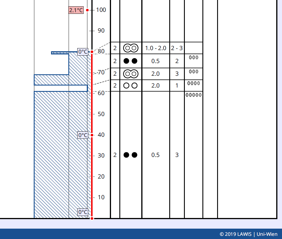
The decisive factor for gliding-snow activity is the moist snowpack at the ground, at least above 2500 m. At low and intermediate altitudes, the snowpack is mostly isotherm, i.e. thoroughly at 0 degrees C.

The red line shows the temperature range inside the snowpack: isotherm. Location: Kals, 1530 m, SE, 30 degrees.

Outlook

The forecast is for higher temperatures. Thus, the snow melting process can raise the frequency of glide-snow avalanches for a short time.

In the heights, trigger-sensitive snowdrift accumulations will be generated increasingly by strong and further intensifying SW winds. For trained skiers and freeriders, they will be easily recognizable and dangerous only for a brief spell.

All in all, quite favourable conditions prevail for skiers and freeriders, as long as one keeps an eye on the gliding snow problem.