Thursday, 25 April 2019

Unstable April weather: increasing danger and avalanche activity

Current situation and trend

The April weather persists:

Current unstable and (for backcountry skiers) infelicitous weather conditions will persist for a bit. Nonetheless, a marked change is about to take place in air masses, according to forecasts of ZAMG: the southerly foehn system is expected to collapse on Friday, 26 April. A cold front will then take its place and spread throughout Tirol from the west. Subsequently, winds will taper off and precipitation will set in, as rainfall up to nearly 2500 m to start with, but then the snowfall level will descend to about 1800 m. Following that outburst, unstable April weather is expected to continue.

Conditions were perfect til Easter Monday. As of 23 April, barrier cloud in the south, accompanied by storm-strength winds.

A striking southerly-foehn scenario

Effects of southerly-foehn scenario on the snowpack: massive melting
together with deeper snowpack at high altitudes along Main Alpine Ridge

The snowpack is becoming wetter and more prone to triggering:

Intense warmth, diffuse radiation, moist air masses - those are the ingredients which make the snowpack wetter. This is occurring in all aspects, but fascinatingly enough, primarily on shady slopes. There, the snowpack has become deeply wet mostly up to intermediate altitudes, but this level is now extending up to high altitudes where (unlike on sunny slopes) there has not yet been any water-seepage, i.e. any re-freezing cycle, that makes the snowpack sluggish. The consequence is heightened proneness to triggering of the snowpack on shady slopes in particular. Due to the rainfall forecast to start tomorrow (Friday, 26 April) this will be amplified a further notch.

At low and intermediate altitudes, the snowpack is already transforming to
sluggish “summer-firn” snow. Allgäu. (photo: 24.04.2019)

Visible increasingly often: a water-soaked snowpack surface.
appx. 2000 m, north, Main Alpine Ridge. (photo: 23.04.2019)

Snow profile on a shady site, exposed to wind all winter long. North, 2340 m. The snowpack is isotherm.
Beneath a crust, depth hoar and faceted crystals were able to be triggered in our snowpack analysis.

Increasing avalanche activity:

The heightened trigger sensitivity of the snowpack as a result of progressing water seepage into the snow also has an effect on avalanche danger: in some regions, danger level 3 - “considerable” - is being reached. We are observing increasingly frequent avalanches, following a period of remarkable calm. Not only loose-snow and glide-snow avalanches, but gradually also isolated naturally triggered slab avalanches are being registered, the latter primarily on shady slopes.

The startlingly large expanse of a naturally triggered slab avalanche at this altitude (1900 m). North-Northwest.
Areas of Untere Gamswaid near Bach in Ausserfern. In the background, loose-snow avalanches as the trigger mechanism of the (entire?) slab. (photo: 24.04.2019)

A slab triggered by an avalanche explosion displaced the Kaunertal Glacier Road. (photo: 21.04.2019)

Relatively fresh loose-snow avalanche in shady terrain.
Altitude zone around 2500 m. North. Northern Stubai Alps. (photo: 24.04.2019)

Currently it is possible to observe the ways in which tiny impulses can unleash huge effects.

This small glide-snow slide swept the thoroughly wet snow into the plummet path.
In the next photo, the plummet path can be seen with avalanche deposit. Silvretta. (photo: 23.04.2019)

The avalanche that goes with the picture above. (photo: 23.04.2019)

Ice chunks from a frozen waterfall as trigger of a wet loose-snow avalanche. Silvretta. (photo: 23.04.2019)

Deposit of a glide-snow avalanche below Gorfenspitze in Paznauntal, triggered about 3:00 pm on 24.04.2019 

Heightened activity of glide-snow avalanches also in Zillertal (photo: 24.04.2019)

The avalanche deposits belonging to the photo above. Recognizable: avalanches can extend all the way to green zones. Zillertal Alps. (photo: 24.04.2019)

Some other items of interest:

Observable in concavities: sand/dust from the Sahara. Silvretta. In the regions subjected to precipitation along the Main Alpine Ridge and in East Tirol, the Sahara stuff was deposited regularly over wide areas. (photo: 23.04.2019)

Snowfall at low altitudes? Or the flight of pollen from willows as a result of foehn wind? Inn Valley. (photo: 21.04.2019)

Wednesday, 24 April 2019

Mediterranean low bringing instable weather. Main danger: wet-snow+glide-snow avalanches.

The sunny and wind-calm weather over the Easter holidays, coupled with top backcountry touring conditions in the mountains, are over.

Tirol currently lies in the path of a powerful southerly air current, wedged between two low-pressure systems over eastern Europe and the western Mediterranean. As a consequence, clouds are accumulating along the Main Alpine Ridge which will bring some fresh snow in East Tirol and along the border to South Tirol. The amounts will be minor, at most 15-20 cm in the classic barrier-cloud regions in the Ötztal and Carnic Alps of the south. In addition, a strong-velocity southerly foehn wind will be blowing which in North Tirol will extend down to the valley floor on Wednesday, 24 April.

The strong foehn wind will intensify another notch on Wednesday, 24.04. On Friday, a cold front will move in and terminate the stormy/gusty wind.

Along the Main Alpine Ridge and in East Tirol, a few centimeters of fresh snow is anticipated above approximately 2000 m on Wednesday, 24.04 .

The southerly airstream will not only bring storm-strength foehn wind and some precipitation, but also transport the sand from the Sahara desert to the Alps in high-altitude moving air masses.

As a result of the southerly airstream, Sahara sand/dust is being whisked to the mountains of Tirol. The skies turn milky-gray with desert dust, which will subsequently be deposited on the snow with precipitation in southern regions.

Variable weather also in Jamtal, Silvretta Group. Heavy cloud and wind hindered warmth from penetrating the snowpack on Tuesday, 23.04.  (23.04.2019).


As a consequence of fresh snow and southerly winds in the areas of precipitation, small snowdrifts are being generated and deposited on steep, shady slopes above 2600 m on top of a loosely bonded old snowpack surface. The snowdrift accumulations can be easily triggered there. The greatest risk is being forced to take a fall.

The major danger remains wet-snow and glide-snow avalanches. The threat depends on the degree to which warmth can radiate outgoingly from the snowpack during the nighttime hours. This, in turn, depends on whether there is cloud cover or not.
On Tuesday night, the skies over Tirol were mostly overcast. The snowpack surface could freeze only very superficially, will soften rapidly Wednesday morning. The snowpack is becoming thoroughly wet to an increasing degree. As a result, wet loose-snow avalanches are possible on extremely steep slopes even in the late morning. This is particularly the case below 2400 m and - when there is solar radiation - on sunny slopes below about 3000 m.

In addition, wet slab avalanches are also possible on steep, shady slopes. As a result of first-time water seepage into persistent weak layers in the old snow (faceted crystals, surface hoar, concave crystals), they can be re-activated, triggered by one sole skier and release as an avalanche. This is particularly the case in central and southern East Tirol between about 2000 and 2400 m, where persistent deep weak layers are evident in the old snowpack base. However, weak layers occur in isolated cases also in North Tirol, at a somewhat higher altitude: between 2400 and 2600 m.
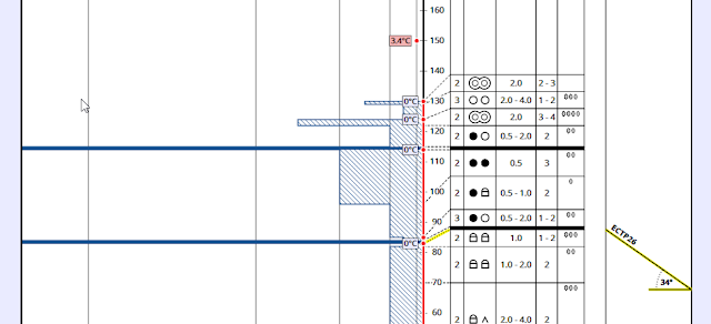
Weak layers of faceted crystals can be activated when they become thoroughly wet for the first time, leading to the release of wet slab avalanches. 2560m, 34°, NW; Pfannknecht, Silvretta. (23.04.2019).

Thursday, 18 April 2019

Classic spring situation, also over Easter holidays

Easter present:

It’s hard to believe, but it really couldn’t be much better: a predominantly stable snowpack. High-pressure weather system. Mostly clear nocturnal skies with adequate outgoing radiation. Rather dry air masses. All of the ingredients for really good springtime conditions, provided one leaves early in the morning and finishes the tour relatively early. At high altitudes there are still some time reserves.

Avalanche danger, quite in accordance with this juncture of the season, is subject to a daily danger cycle. Supported by current weather forecasts of ZAMG weather headquarters, the Easter holidays can expect pretty good conditions, like the ones which currently reign: low danger in early hours and into the morning. Moderate danger in the afternoon. The main problem stems from wet loose-snow avalanches which are generally triggerable by external impulses. Apart from that, isolated glide-snow avalanches and slides are also being reported.

Far better than words to describe the current situation are pictures:

Snow quality:

The snowpack, following nights of clear skies, is generally frozen with a crust capable of bearing loads. Zillertal Alps.  (photo: 18.04.2019)

Breakable melt-freeze crusts are becoming rare. They are most likely on shady slopes at high altitudes in regions where recent snowfall has been heaviest. Zillertal Alps. (photo: 18.04.2019)

Powder in high alpine, shady terrain. Central Stubai Alps. (photo: 16.04.2019)

If the descent is launched early enough, corn snow is a dream-come-true reward.  (photo: 18.04.2019)

In many places at high altitudes near ridgelines in shady terrain: surface hoar (Nigg Effect). Currently this does not present a problem. We continue to follow this development (deterioration from radiation or blanketing by fresh snow or snowdrifts). Zillertal Alps, 3090 m, north. (photo: 18.04.2019)

Potential dangers:

Wet loose-snow avalanches are the major danger. Central Stubai Alps. (photo: 16.04.2019)

Moist air masses, particularly in the central sector of North Tirol, amplified releases of naturally triggered loose-snow avalanches on 17 April. Northern Stubai Alps.  (photo: 17.04.2019)

In the meantime, the air has become significantly drier (18 April 2019) and the likelihood of naturally triggered loose-snow avalanches correspondingly reduced. The loose-snow avalanche in the photo was triggered by a falling stone on 18 April.

Everywhere, where the snow is shallow and the snowpack is thoroughly wet, the melt-freeze crust (if sufficiently wet) can fracture under the impulse of skiers or freeriders and release a slide. 2200 m, west, midday. (photo: 18.04.2019)

The last blogs reported an old-snow problem which has in the meantime been transferred to high alpine regions. Slab avalanches which reach medium size are now triggerable only in extremely steep, shady terrain by large additional loading, and in highly isolated cases. All observations and stability tests demonstrate a generally adequate level of consolidation. Northern Stubai Alps.  (photo: 16.04.2019)

Elsewhere, please pay all due heed: cornices and slipping and falling on a hardened snowpack surface. Nauders mountains. (photo: 28.03.2019) 

Nothing new this winter: glide-snow slides and, in isolated cases, glide-snow avalanches on steep, grass-covered slopes. Many of these have already released over the course of this winter.

Equally worthy of mention: some glaciers were completely windblown during the winter as a result of the frequent NW weather systems. In some places, the deep wintery picture presents the illusion of well covered crevices.

Cannot be stopped, cannot be slowed: the spring...

Wisdom handed down by our ancestors: as soon as the falconer appears in the Northern Massif, the spring is well on its way. (photo: 18.04.2019)

Just an instant ago covered with snow, yet they already begin to bloom.  (photo: 18.04.2019)

We wish all our readers a happy and accident-free Easter!

Tuesday, 16 April 2019

Short update on near-surface weak layers

Zooming in on the already mentioned near-surface weak layers, we were able to bring the picture into sharper focus. These layers were responsible for several avalanches involving persons in the regions where recent snowfall has been heaviest (see last blog). The avalanches were without consequences for the backcountry skiers.

Slab avalanches and settling noises were registered in the following reports: west, between 2400 and 2900 m; northern aspect between 2400 and 3000 m. This mostly involved the weak layer surrounding faceted crystals, i.e. danger pattern 4 (cold on warm) immediately bordering the crust (above it and below it). Covered surface hoar also played a role, particularly near the upper limit of the fog and in high alpine terrain adjacent to ridgelines (Nigg Effect).

These regional weak layers in very steep terrain are of great significance to backcountry skiers and freeriders. Based on the weather forecasts, we assume that these near-surface weak layers will swiftly bond during the next few days. The process will take longest in extremely steep, shady terrain.

Also requiring attentiveness: As the snowpack becomes wetter and wetter, loose-snow avalanches can be expected with increasing frequency, if not with the same intensity as yesterday, 15 April; they can also be triggered by the impulse of human weight.

In the next few days, classic springtime conditions will prevail to an ever greater degree, including fluctuating threats of the daytime danger cycle. The name of the game is: start early, descend early.

Finally, a few snapshots from 15 April:

Avalanches on Stubai Glacier: right slab triggered by skiers; left slab triggered naturally; north 2700 m. (photo: 15.04.2019)

Avalanche triggered on Rosskarscharte, northern Stubai Alps, north, 3000 m. (photo: 15.04.2019)

Avalanche triggered on Oberstkogel, northern Stubai Alps, north, 2700 m. (photo: 15.04.2019)

Below the Zischgenscharte in northern Stubai Alps at about 3000 m, covered surface hoar (Nigg Effect) was the weak layer. (photo: Lukas Ruetz)

Fabulous powder in southern Ötztal Alps  (photo: 15.04.2019)

Glide-snow avalanches in Fimbatal, Silvretta  (photo: 14.04.2019)

Monday, 15 April 2019

NE barrier clouds will bring fresh snow regionally – heightened avalanche activity due to solar radiation

Recent weather has suffered under the the onus of a NE barrier cloud zone. In Stubai, Ötztal and parts of Zillertal Alps, up to 60 cm of fresh snow was registered from place to place. The gradient in fresh snow depths was frequently impressive.


There was next to no wind. Yesterday, 14 April, heightened avalanche activity was reported during the midday hours, generally loose-snow avalanches but also slab avalanches in the areas where snowfall was heaviest, and in all aspects. The necessary slab for a slab avalanche (a bonded snow mass above a weak layer) was generated by increasing warmth and diffuse radiation. In all likelihood the weak layer was comprised mostly of cold, loose-bonded powder snow. In the borderline foggy zones there may have also been surface hoar. We have recently observed the formation of faceted crystals near the surface (danger pattern: cold on warm) which may also have played a role (see last blog).

In a nutshell: due to increasing solar radiation and daytime warming, we can expect a highly active avalanche day today, particularly where recent snowfall has been heaviest. To an increasing extent, these will be loose-snow avalanches. Naturally triggered slab avalanches are still possible in high alpine regions, but in all likelihood today, 15 April, triggered by large additional loading, predominantly in very steep to extremely steep terrain.