Tirol currently lies in the path of a powerful southerly air current, wedged between two low-pressure systems over eastern Europe and the western Mediterranean. As a consequence, clouds are accumulating along the Main Alpine Ridge which will bring some fresh snow in East Tirol and along the border to South Tirol. The amounts will be minor, at most 15-20 cm in the classic barrier-cloud regions in the Ötztal and Carnic Alps of the south. In addition, a strong-velocity southerly foehn wind will be blowing which in North Tirol will extend down to the valley floor on Wednesday, 24 April.
 |
| The strong foehn wind will intensify another notch on Wednesday, 24.04. On Friday, a cold front will move in and terminate the stormy/gusty wind. |
 |
| Along the Main Alpine Ridge and in East Tirol, a few centimeters of fresh snow is anticipated above approximately 2000 m on Wednesday, 24.04 . |
The southerly airstream will not only bring storm-strength foehn wind and some precipitation, but also transport the sand from the Sahara desert to the Alps in high-altitude moving air masses.
 |
| As a result of the southerly airstream, Sahara sand/dust is being whisked to the mountains of Tirol. The skies turn milky-gray with desert dust, which will subsequently be deposited on the snow with precipitation in southern regions. |
 |
| Variable weather also in Jamtal, Silvretta Group. Heavy cloud and wind hindered warmth from penetrating the snowpack on Tuesday, 23.04. (23.04.2019). |
As a consequence of fresh snow and southerly winds in the areas of precipitation, small snowdrifts are being generated and deposited on steep, shady slopes above 2600 m on top of a loosely bonded old snowpack surface. The snowdrift accumulations can be easily triggered there. The greatest risk is being forced to take a fall.
The major danger remains wet-snow and glide-snow avalanches. The threat depends on the degree to which warmth can radiate outgoingly from the snowpack during the nighttime hours. This, in turn, depends on whether there is cloud cover or not.
On Tuesday night, the skies over Tirol were mostly overcast. The snowpack surface could freeze only very superficially, will soften rapidly Wednesday morning. The snowpack is becoming thoroughly wet to an increasing degree. As a result, wet loose-snow avalanches are possible on extremely steep slopes even in the late morning. This is particularly the case below 2400 m and - when there is solar radiation - on sunny slopes below about 3000 m.
In addition, wet slab avalanches are also possible on steep, shady slopes. As a result of first-time water seepage into persistent weak layers in the old snow (faceted crystals, surface hoar, concave crystals), they can be re-activated, triggered by one sole skier and release as an avalanche. This is particularly the case in central and southern East Tirol between about 2000 and 2400 m, where persistent deep weak layers are evident in the old snowpack base. However, weak layers occur in isolated cases also in North Tirol, at a somewhat higher altitude: between 2400 and 2600 m.
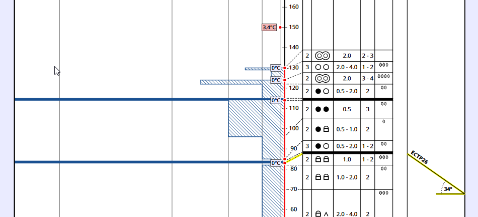 |
| Weak layers of faceted crystals can be activated when they become thoroughly wet for the first time, leading to the release of wet slab avalanches. 2560m, 34°, NW; Pfannknecht, Silvretta. (23.04.2019). |