Saturday, 18 March 2023

Recent avalanches mostly in NE/E/SE aspects above 2500m (persistent weak layer) – Heed daytime danger cycle

 Summing it up


Several avalanches have been triggered by winter sports enthusiasts during the last few days, increasingly on very steep slopes above 2500m in NE/E/SE aspects. The heightened proneness to triggering of weak layers inside the snowpack was the result of pronounced slabs (see last blog) which formed recently. Most avalanches releases were caused by a persistent weak layer (long-enduring, hard-to-recognize weak layer inside the snowpack). In one avalanche accident near the Scheid in the Samnaun Massif, a winter sports enthusiast died today in backcountry terrain. In other avalanches in recent days, persons were also injured.

As always in springtime, small shifts in weather can have huge and swift effects in avalanche danger. Major factors, apart from air temperature and (diffuse) solar radiation, include in particular air moisture. And of eternal importance: whether nocturnal outgoing radiation is impeded by clouds. Therefore, pay close attention in open terrain to the degree of wetness of the snowpack. This leads to loss of firmness and a rapid increase in avalanche danger.


Fatal avalanche accident in Samnaun Massif

Today (17.03.2023) a winter sports enthusiast lost her life in open skiing terrain in the vicinity of the upper Scheid Lift (ski area Serfaus, Fiss, Ladis) in an avalanche. The slab avalanche triggered when she descended in backcountry ski terrain down an extremely steep NE-facing slope. The fracture occurred at 2550m. She was caught by the avalanche and completely buried in snow masses. She had no beamer. Following an extensive search including avalanche dogs, she was finally found lifeless. The problem which caused the avalanche was a persistent weak layer. Tomorrow (18.03.2023) we will carry out a thorough and detailed snowpack/avalanche analysis together with the Alpine Police (snow profiles will be published on Lawis).


Lawinenunfall Scheid vom 17.03.2023. Der Pfeil zeigt die Einfahrtsspur, der Kreis die Verschüttungsstelle.
Avalanche accident Scheid, 17.03.2023. Arrow points to the entry track, circle is where she was buried. (photo: 17.03.2023)


Die Ellipse zeigt in etwa den Bereich des Lawinenabgangs. Es handelt sich um extrem steiles Gelände. In violett: Lifte des Skigebietes Serfaus, Fiss, Ladis
 Ellipse shows area of avalanche. It is extremely steep terrain. Violet: lifts of the ski area Serfaus, Fiss, Ladis


Einfahrtsbereich samt einem Teil des Lawinenanrisses (Foto: 17.03.2023)
Entry zone including a part of avalanche fracture (photo: 17.03.2023)


Other reported avalanches of this week

During this week, a number of avalanches were reported to headquarters Tirol. What stands out (please note this in planning tours) is that most occurred on NE/E/SE-facing slopes above 2500 m. Here is the list:

09.03.2023: Pflerscher Pinggl, central Stubai Alps: no one buried
11.03.2023: Hoher Seeblaskogel, Sellrain, Alpeiner B.: no one buried
12.03.2023: Litnisschrofen, Allgäu Alps: no one buried
12.03.2023: Galtenberg, western Kitzbühel Alps: no one buried 
12.03.2023: Breite Scharte, Sellrain, Alpeiner Berge: NO, 2500m (persistent weak layer), 1 person totally buried, injured
12.03.2023: Hoher Burgstall, Sellrain, Alpeiner Berge: NO, 2500m (persistent weak layer), 1 person swept along, not buried
13.03.2023: Murkarspitze, Sellrain, Alpeiner Berge: no one buried 
13.03.2023: Hintere Neder, northern Zillertal Alps: no one buried
13.03.2023: Walfeskar, Sellrain, Alpeiner Berge: SO, 2750m (persistent weak layer), 1 person partly buried, injured
13.03.2023: Zwölferkopf, Samnaun Massif; NW, 2500m: no one buried 
15.03.2023: Alblittköpfe, eastern Verwall Massif: NO 2500m (persistent weak layer), 1 person buried, injured
15.03.2023: Eisgrat, central Stubai Alps: SO, 2860m (snowdrift problem), no one buried
15.03.2023: Hinteres Rendl, western Verwall Massif: no one buried
15.03.2023: Mitterkarspitze, western Verwall Massif: no one buried 
15.03.2023: Grawa, central Stubai Alps: no one buried
16.03.2023: Riefenkopf, Samnaun Massif: NO, 2600m, (persistent weak layer) 2 persons, no injuries
16.03.2023: Rostocker Eck, Venediger Massif: no one buried
16.03.2023: Weißseejoch, Glockturm Massif: N, 2500m, no one buried
17.03.2023: Scheid, Samnaun Massif: NO, 2550m (persistent weak layer), 1 person dies
17.03.2023: Riffljoch, Glockturm Massif: no one buried
17.03.2023: Tiefenbachferner, Weisskugel Massif: SO, 3000m (snowdrift problem), no one buried
17.03.2023: Gaiskogel, Kühtai-Geigenkamm: NW, 2580m, no one buried

Here are some photos of selected avalanches:


Lawinenabgang Breite Scharte mit Verschüttungsstelle. Eine 5-köpfige Gruppe befand sich im Aufstieg. 1 Person wurde total verschüttet, konnte mit LVS-Gerät geortet und aus 1,5m ausgegraben werden. Person war bei Bergung bewusstlos, atmete nach Bergung wieder. (Der Lawinenanriss konnte aufgrund nachfolgenden Schneefalls und Windeinfluss nicht mehr exakt nachvollzogen werden.) (Foto: 15.03.2023)
Avalanche release on Breite Scharte with point of burial marked. A 5-person group was in their ascent. One person was totally buried, could be found with beamer and dug out of 1.5 metres of snow. The person was unconscious, but started to breathe after the rescue. (Avalanche fracture could not be completely explained due to snowfall and wind immediately following the release.) (photo: 15.03.2023)


Lawinenabgang Walfeskar (im Nahbereich der Lawine Breite Scharte). Eine 6-köpfige Gruppe befand sich bei der Abfahrt vom Zwieselbacher Rosskogel über das Walfeskar in Richtung Pforzheimer Hütte. Eine Person wurde von der Lawine erfasst, mitgerissen, teilverschüttet und verletzt. (Foto: 15.03.2023)
Avalanche Walfeskar (near the Breite Scharte avalanche). A group of six was in their descent from Zwieselbacher Rosskogel over the Walfeskar towards Pforzheimer Hütte. One person was caught in the avalanche, swept along and injured. (photo: 15.03.2023)


Lawinenabgang Alblittköpfe mit Einfahrtsspur und Verschüttungsstelle. Die verschüttete und verletzte Person gehörte einer Gruppe der "Dutch Freeride Championsship" an. Diese Gruppe fuhr während des Tages bereits einige Linien im freien Skiraum des Skigebietes Kappl. (Foto: 15.03.2023)
Avalanche Alblittköpfe with entry track and point of burial marked. The buried and injured person was part of a group known as “Dutch Freeride Championship.” They traced several different paths in backcountry at the Kappl ski area. (photo: 15.03.2023)


Im Nahbereich des Tiefenbachgletschers: Kürzlich gebildeter Triebschnee, der sich bei der Abfahrt eines Wintersportlers löste. Die Schneeoberfläche war auf 3000m in dem SO-Hang bereits angefeuchtet. (Foto: 17.03.2023)
In the vicinity of Tiefenbach Glacier: recently generated snowdrift accumulations which triggered when a winter sports enthusiast descended. The snowpack surface at 3000m on a SE-facing slope was already moist. (photo: 17.03.2023)


Während der vergangenen Woche lösten v.a. während der Schneefälle v.a. im Westen Nordtirols einige spontane Schneebrettlawinen. Westliche Verwallgruppe (Foto: 15.03.2023)
Several slab avalanches triggered naturally last week, particularly in the western part of North Tirol.
Western Verwall Massif (photo: 15.03.2023)  


Immer wieder Niederschläge und ein Auf und Ab bei den Temperaturen förderten die Störanfälligkeit der Schneedecke
Repeated bouts of precipitation and fluctuating temperatures enhanced snowpack’s proneness to triggering


Springtime comes knocking - Heed daytime-induced cycle of avalanche danger

To round out our last blog we would like to devote some attention to the anticipated further development of conditions. Tomorrow (Saturday, 18.03) will be a complex weather situation. Air temperature will recede somewhat from today’s (17.03) levels and the air will become more moist. Dust blown up from the Sahara Desert will fill the skies. On steep west-facing slopes it may still occur in the afternoon that water seeps down to deeper layers. Expansively metamorphosed (faceted, often encrusted) weak layers could be weakened still further and the snowpack could become prone to triggering.


Unser Schneedeckenmodell "Snowpack" zeigt, dass Wasser in einem simulierten 38° geneigten Westhang bei der Station Falkaunsalpe im Kaunertal morgen am 18.03. bis in bodennahe Schichten eindringt.
Our “Snowpack” model shows that water on a simulated 38° gradient west-facing slope at Falkaunsalpe Station in Kaunertal will seep down to ground-level layers tomorrow (18.03).


Bei der höher gelegenen Station Sonnbergalm in der Gurgler Gruppe dauert der Wassereintrag bis zum Boden in einem simulierten 38° steilen Hang noch etwas länger.
At the higher Sonnbergalm Station in the Gurgler Massif, water seepage down to the ground will take somewhat longer, on a simulated 38° gradient slope.

 
Durch den Impuls einer spontanen nassen Lockerschneelawine löste sich heute am 17.03. um 11:30 Uhr eine Schneebrettlawine. Steintalspitze, Kühtai
Through the impulse of a naturally triggered wet loose-snow avalanche, a slab avalanche was triggered today (17.03) at 11:30 am. East-facing slope, 2750m. Steintalspitze, Kühtai


On Sunday, all signs point to a brief pause in spring, according to current weather forecasts. A minor perturbance will make the zero-degree level descend to 2000m. The sun will presumably be shaded. Next week, mild weather will return and continue.
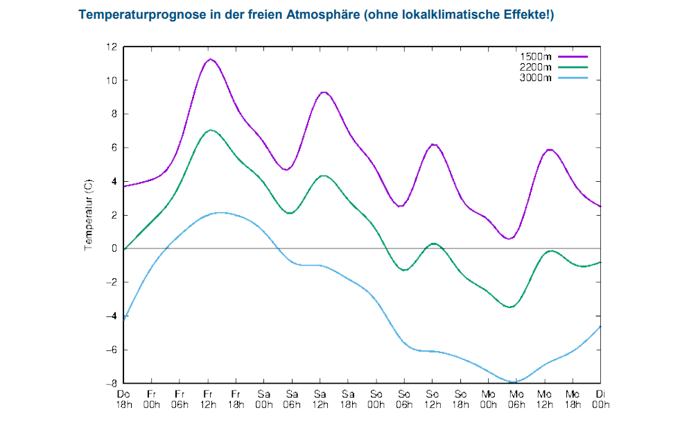

Temperaturverlauf der kommenden Tage. Heute am 17.03. war es vergleichsweise am wärmsten.
Temperature development in coming days. Today (17.03) was the warmest.


Das Wettergeschehen kann insbesondere im Frühjahr einen kurzfristig sehr massiven Einfluss auf die Schneedecke und die Lawinengefahr haben. Eine gute Lawinenprognose ist deshalb besonders herausfordernd. "König bei der Beurteilung der Lawinengefahr ist man deshalb nur direkt vor Ort" (Foto: 15.03.2023)
Spring weather has massive impact on the snowpack and on avalanche danger. A good avalanche forecast is especially challenging for that reason. To master that art, you need to be on-site. (photo: 15.03.2023)


Eine sehr wechselhafte Woche mit Temperatursprüngen, immer wieder Niederschlag (Schnee und Regen) samt z.T. viel Wind geht zu Ende.
A week full of fluctuations, wildly varied leaps of temperature, repeated bouts of precipitation (snow and rain) including lots of wind in places, is coming to an end.


Don’t forget: last week also offered winter sports enthusiasts some good powder. 


Pulverschnee in weiten Teilen Tirols. Dieser wird durch (diffusen) Strahlungseinfluss von Tag zu Tag rarer. (Foto: 15.03.2023, (c) Lukas Ruetz)
Powder widespread in Tirol, which will become rarer day by day due to diffuse radiation. 
(photo: 15.03.2023, (c) Lukas Ruetz)

 
The upshot

Pay close attention to the moistness of the snowpack. Focus on the devilishly tricky persistent weak layer problem. It starts at 2200m on shady slopes, above 2400m on east-facing and west-facing slopes, especially where snowfall has been heaviest. Caution urged on little-tracked very steep terrain.


Snowpack analysis, the foundation of our work. (photo: 15.03.2023, (c) Lukas Ruetz)

Wednesday, 15 March 2023

Thorough wetness is weakening the snowpack – More pronounced daytime danger cycle

 To start off


Mild weather during the next few days is intensifying the wet-snow problem. Wetness seeping into snowpack is weakening it. Avalanches can more easily be triggered by winter sports enthusiasts. Also naturally triggered avalanches are more likely. Crucial: good tour planning, reasonable time allotment, adequate equipment and experience in assessing avalanche danger on-site.

 A pronounced slab is developing

As we all know, several ingredients are necessary for slab avalanches: at least one weak layer inside the snowpack; on top of that a “slab” - in other words, a bonded mass of snow; in addition, the terrain must be steep enough for the slab to release, i.e. be ejected. This steepness gradient typically lies at 30°. Variable weather recently brought us several batches of fresh snow. Strong winds transported it and generated wide-ranging snowdrift accumulations. An added injection to fresh snow and drifts bonding was supplied by diffuse radiation and higher temperatures. It all adds up to one thing: a highly pronounced slab.


48h-Schneedifferenz 13.03.-14.03.
48-hr snow difference 13.03.-14.03.


Diffuse Strahlung, hohe Luftfeuchtigkeit fördern die Bildung eines "Bretts". (Foto: 11.03.2023)
Diffuse radiation, high air moisture enhance slab formation. (photo: 11.03.2023)

Weak layers further weakened by water seepage

Weak layers inside the snowpack are currently (15.03) likeliest to trigger on shady slopes at 2000-2400m, and on west-facing and east-facing slopes above 2400m. East-facing and northeast-facing slopes above 2500m appear to be the least favorable of all. The reason for this lies in the expansively metamorphosed weak layers inside the snowpack (faceted crystals, depth hoar). On shady slopes, we see increasing water seepage down to the ground-level layers. On sunny slopes the snowpack became thoroughly wet much too often in this overly mild winter. Ground-level weak layers were thereby “activated” up to high altitudes on south-facing slopes, but also on west-facing and east-facing slopes up to about 2400m. For that reason we focused on the west-facing and east-facing slopes above 2400m, since they are becoming thoroughly wet for the first time. East-facing and northeast-facing slopes are more critical because there are more expansively metamorphosed layers near the surface beneath a melt-freeze crust whose enormity depends on altitude and steepness. 


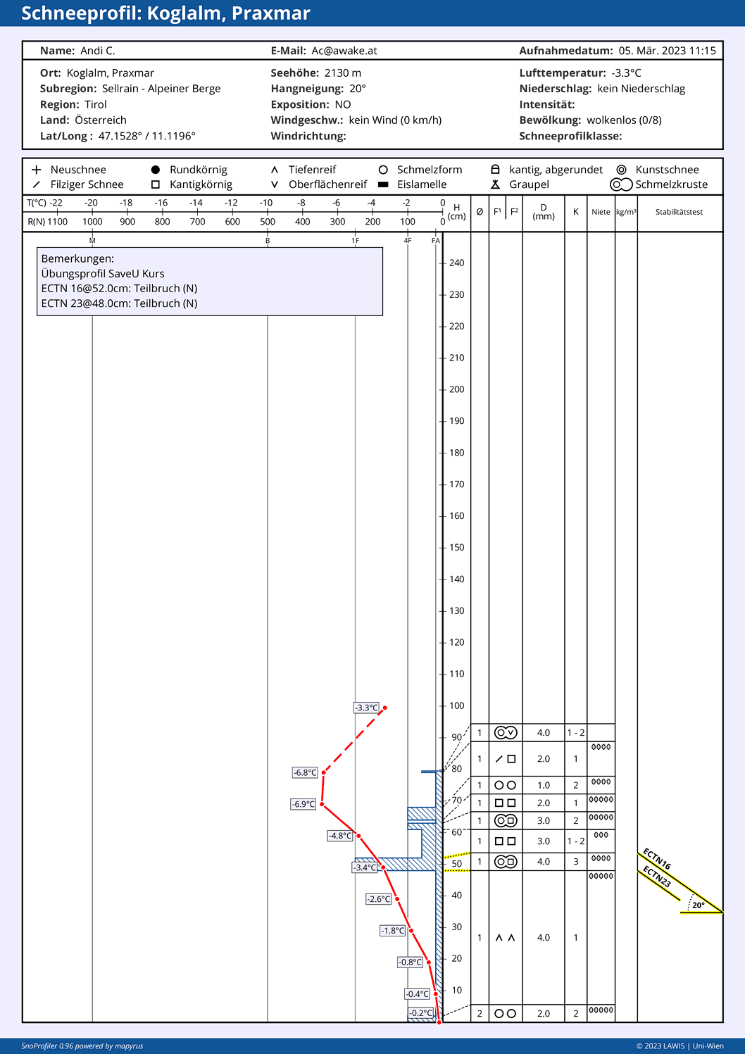
Die rote Linie zeigt die Schneetemperatur. Auf 2140m Nord sind die Temperaturreserven nur mehr gering ausgrägt. D.h. bei weiterem Wärmeeintrag wird es zu einer raschen Durchnässung bis zum Boden kommen.
The red line denotes snow temperature. At 2140m North, temperature reserves are very low. That means, with a bit more warmth, the snowpack will swiftly become thoroughly wet down to the ground.


Increased avalanche activity

Following several rounds of snowfall and subsequent solar radiation, highly frequent loose-snow avalanches can be expected in extremely steep terrain at this juncture of the season. Furthermore, in the regions where snowfall has been heaviest, increasingly frequent glide-snow slides and glide-snow avalanches can be expected on steep grass-covered slopes. AND VERY IMPORTANT: slab avalanches can far more easily be triggered by winter sports enthusiasts. As the weekend approaches, naturally triggered avalanches will also become more likely. The next blog will be published tomorrow (16.03). In it the recent avalanches near the Pforzheimer Hütte (each on E/NE facing slopes above 2400m) will be analyzed. 


Nasse Lockerschneelawine in den Deferegger Alpen (Foto: 14.03.2023)
Wet loose-snow avalanche in the Deferegger Alps (photo: 14.03.2023)

Friday, 10 March 2023

Variable weather – Variable snowpack

 The overall picture


Springtime is well known to have a few surprises up its sleeve. Accordingly, the snowpack can moisten thoroughly (at least the surface layer) within the shortest imaginable time due to diffuse radiation, increased air moisture and higher temperatures. This, in turn, transforms the slab. Or else, water seeps down into the snowpack and raises the proneness to triggering. Contrarily, it is also possible that an inflow of dry, cold air masses rapidly stabilize a moist snowpack. What we are trying to point out is this: in spring it is especially important to train a sharp eye on the weather and its effects on the snowpack, and then react accordingly.


Still quite favorable avalanche conditions by and large – but avalanches are possible nonetheless

During the last 10 days, moderate-to-low avalanche danger prevailed in Tirol, and this assessment continues today (10 March 2023). The snowpack is highly irregular, frequently quite stable.


Während der vergangenen Wochen wurde häufig auch extrem steiles Gelände begangen bzw. befahren. Osttirol (Foto: 09.03.2023)
During the last few weeks, extremely steep terrain was often the playground of winter sports enthusiasts. East Tirol (photo: 09.03.2023)


Nevertheless, we still pinpoint weak layers which can be triggered by winter sports enthusiasts. This is the case mostly in shady terrain above 2200m, increasingly frequent also on east-facing ridgeline slopes at heightened altitudes. Most of the recent avalanche triggerings stemmed from the persistent weak layer we all know about (with weak layers near ground level). The theme was treated in detail in our last blog. Cold on warm (dp.4) has been repeatedly observed in backcountry terrain. This layer turned ugly only in very isolated cases, we believe, most likely on shady slopes at 2100 to 2400m.


Lawinenauslösung Blankenstein bei Innervillgraten in den Östlichen Deferegger Alpen. 04.03.2023 2400m, NO, 40°. Eine Person verletzte sich am Knie.
Avalanche triggering Blankenstein near Innervillgraten, eastern Deferegger Alps.
04.03.2023 2400m, NE, 40°. One person suffered a knee injury.


Die herausmodellierte Schwachschicht (unterhalb einer dünnen Schmelzkruste) entstand durch gm.4 2340m, NW, 36°. Östliche Lechtaler Alpen (Foto: 03.03.2023)
The weak layer beneath a thin melt-freeze crust was generated by dp.4
2340m, NW, 36°. Eastern Lechtal Alps (photo: 03.03.2023)


Profil zu obigem Foto. Stabilitätstests mit vollständigen Brüchen (03.03.2023)
Profile for above photo. Stability tests with complete fractures  (03.03.2023)


Diffuse radiation

Today (9 March 2023) we observed how surface-near layers in shady terrain at 2200m can become moistened by diffuse radiation and thereby become denser. A snowpack which to date is quite low in internal tension and a loose fundament can thereby have the prerequisites for generating a slab (slab plus weak layer). Over compressed space the danger of slab avalanches can increase correspondingly.


Durch diffuse Strahlung wird viel Energie von der Schneedecke aufgenommen. Silvretta  (Foto: 08.03.2023)
When radiation is diffuse, high amounts of energy are absorbed by the snowpack.
Silvretta (photo: 08.03.2023)


Bei diesem Profil ist die Schneedecke noch trocken. Feuchtigkeitseintrag durch diffuse Strahlung kann die oberflächennahen Schichten verdichten. Schneebrettauslösungen können möglich werden. (Profil vom 05.03.2023)
In this profile the snowpack is still dry. Moisture from diffuse radiation can compress the density of the surface-near layers, thereby making slab triggerings possible. (profile from 05.03.2023)


Diffuse radiation can also destroy the near-surface weak layers. This is important because surface hoar has formed massively in recent weeks. This was often due to the tenacious fog and nocturnal outgoing radiation. In some places the surface hoar was generated due to the Nigg Effect.


Die bei uns während der vergangenen 10 Tagen eingelangten Meldungen über Oberflächenreif (inkl. 09.03.2023)
Reports of surface hoar which reached us during the last 10 days (inc. 09.03.2023)


Oberflächenreif in den Nördlichen Zillertaler Alpen (Foto: 04.03.2023)
Surface hoar in northern Zillertal Alps (photo: 04.03.2023)


Kammnaher Oberflächenreif aufgrund des Nigg-Effekts. Kaunergrat (Foto: 04.03.2023)
Ridgeline surface hoar due to Nigg Effect. Kaunergrat (photo: 04.03.2023) 


The surface hoar had a tough time of it: on the one hand, strong westerly winds; on the other, diffuse radiation on 8 and 9 March which destroyed a great deal of it. Nevertheless, some of it survived...


Am 08.03. stieg die Luftfeuchtigkeit markant an. Im Westen des Landes schneite es vergleichsweise am meisten. Meist waren es 5-10cm. Die Voraussetzungen für diffuse Strahlung waren sowohl am 08.03. als auch am 09.03. gegeben. Bezeichnend war auch der vielerorts starke Wind.
On 8 March, air moisture increased noticeably. In the western regions heavy snowfall arrived, mostly 5-10 cm. The prerequisites for diffuse radiation existed on 8 and 9 March. Strong winds were highly indicative.


What’s coming?

Central Europe lies in the path of a powerful westerly air current according to Geosphere Austria. Thus, frontal systems will be repeatedly transported to Austria. Between Friday, 10.03 and Saturday 11.03, some snowfall is expected, most in western regions, about 20 cm is anticipated, more from place to place. The snowfall level is expected to descend to low lying areas. Subsequently, variable conditions will reign, including winds and milder temperatures.

72h Neuschnee zwischen 10.03. und 12.03. für Tirol


Avalanche danger levels are not expected to change significantly. Following the snowfall on 10-12 March, we anticipate increasingly frequent loose-snow avalanches.


Frische Lockerschneelawinen in der Silvretta vom 09.03.2023
Fresh loose-snow avalanches in the Silvretta from 09.03.2023


In den neuschneereicheren Gebieten kann unmittelbar nach Schneefällen wohl kurzfristig Pulverschnee genossen werden. (Foto: 09.03.2023)
In the regions where snowfall has been heaviest, fabulous powder is often to be enjoyed for a short time following the precipitation. (photo: 09.03.2023) 

Friday, 3 March 2023

Generally favorable avalanche conditions – Little snow in many places – Danger Pattern “cold on warm” frequently developing

 Summing it up


Since yesterday, 01.03.2023, the avalanche danger level in Tirol has been low. We assume there are only few danger zones where avalanches can be triggered, if at all, then on shady slopes at high altitudes. Nevertheless, we are currently observing the development of a potential weak layer due to Danger Pattern “cold on warm” (dp.4). In isolated cases this layer could become a problem during the next few days. We are training a sharp eye and lots of research on just where this might happen. In this blog you can read about the latest stage of our knowledge regarding dp.4.


Finally snow - esp. in the northern and eastern regions

Last week bore the stamp of initial snowfall, striking mainly in the northern and eastern regions of the land where generally 30-50cm of fresh snow was registered. Further south the amounts of fresh fallen snow were noticeably less. Due to low temperatures the snow was quite loose. Winds generated snow transport. We were often confronted with a new-snow problem (where danger zones are not visible to the naked eye). In the regions with least precipitation, on the other hand, a snowdrift problem dominated (wind-loaded masses recognizable in open terrain, could be circumvented). During the last few days, beautiful weather prevailed, while southern regions were overcast. There was some snow in the south on 01-02 March, mostly 5-10cm.


72h-Neuschneesumme zwischen Freitag, den 24.02. Montag, den 27.02.2023
72-hr fresh snow between Friday 24.02 and Monday 27.02.2023


Etwas Schnee im Süden: 24h-Neuschneesumme zwischen 01.03. und 02.03.2023
Some fresh snow in the south: 24-hr snowfall between 01.03. and 02.03.2023


Eine schöne Winterlandschaft nach den Schneefällen ab dem 24.02.2023. Dennoch: Bei der Abfahrt muss man immer noch auf möglichen Steinkontakt achten - Zentrale Lechtaler Alpen (Foto: 28.02.2023)
A gorgeous winter landscape following the snowfall from 24.02.2023. Nevertheless, still danger of rocks on the descent. Central Lechtal Alps. (photo: 28.02.2023)


Toller Pulverschnee in den Westlichen Kitzbüheler Alpen (Foto: 28.02.2023)
Superb powder in western Kitzbühel Alps (photo: 28.02.2023)


Following the snowfall, increasingly frequent loose-snow avalanches were observed in extremely steep terrain. Slab avalanches were generally small, fractured beneath the fresh fallen snow (cold, loose snow blanketed by freshly generated drifts). In addition, the snow tended to slide over steep grass-covered slopes.


Lockerschneelawinen in den Westlichen Lechtaler Alpen (Foto: 01.03.2023)
Loose-snow avalanche in western Lechtal Alps (photo: 01.03.2023)


Kleine spontane Schneebrettlawine, vermutlich vom 26.02. in der Grieskogelgruppe (Foto: 02.03.2023)
Small naturally triggered slab avalanche, presumably on 26.02. Grieskogel Massif (photo: 02.03.2023)


Gleitschneerutsche in den Östlichen Lechtaler Alpen (Foto: 28.02.2023)
Glide-snow slide in eastern Lechtal Alps (photo: 28.02.2023)


Danger Pattern "cold on warm" (dp.4)

Danger Pattern “cold on warm” occurs whenever an initially moist or wet snowpack surface gets blanketed by cold snow. Due to the great temperature disparity over small spaces, an expansively metamorphosed (faceted) layer can develop with a bit of delay. Currently we see such a development taking place. This process is important in the northern and eastern regions which recently had heavy snowfall. There, in addition to the formation of a potential weak layer, there is also the crucial slab. Today, 02.03, two reports about settling noises arrived at headquarters which can in all likelihood be attributed to this process (regions Kalkkögel and Sellrain). Dp.4 may also be the cause of an avalanche in the Kalkkögeln, presumably on 28.02 in the afternoon or 01.03 in the morning.


Voraussetzungen für "kalt auf warm": Ellipse: Feuchte Schneeoberfläche. Danach Schneefall und fallende Temperaturen
Prerequisites for “cold on warm:” ellipse denotes moist surface; then snowfall plus dropping temperatures.


Current estimate for pinpointing “cold on warm”

At the presenet moment there are relatively few reports of a potential “cold on warm” problem. We base this not only on reports, but also on our own open terrain explorations and snow profiles.

The forming of a threatening weak layer is currently most possible, in our opinion, in the following zones or is already the case there:
  • North, altitudes 2100m-2300m
  • East / Northeast and West and Northwest: 2100m-2500m
  • South 2500m and above

Please assist us

We have assigned this project to all our observers: be attentive to this development over the next few days and inform us. The more comprehensive our information is, the clearer the overall picture becomes. For that reason, we turn to those of you who like to have a look inside the snowpack. What interests us most is whether faceted crystals have formed near the melt-freeze crust which formed last week. Of course, a stability test would be even better, e.g. a quickly executed ECT. We look forward to lots of reports from you, mail them to  lawine@tirol.gv.at  


Ein Blick in die Schneedecke hilft, die Entwicklung von gm.4 besser einzuschätzen - Venedigergruppe (Foto: 01.03.2023)
A glance into the snowpack helps us to assess the development of dp.4 - Venediger Massif
(photo: 01.03.2023)


Schneebrettlawine mit einer Einfahrtsspur eines Snowboarders (oberer Anrissbereich zwischen den Felsen) auf 2300m Nord. (Foto: 01.03.2023)
Slab avalanche with entry track of a snowboarder (upper fracture zone between rocks) at 2300m North (photo: 01.03.2023)


Vergleichsfoto zu obigem Foto: Am 28.02. nachmittags war an dieser Stelle nur eine querende Spur zu sehen. Die Lawine war noch nicht abgegangen. (Foto: 28.02.2023)
Photo for comparison: on 28.02 in the afternoon, only one traverse track could be seen. The avalanche had not yet triggered. (photo: 28.02.2023)


Der Pfeil zeigt auf eine dünne kantige Schicht unterhalb einer dünnen Schmelzkruste. Der Stabilitätstest zeigte hier stabile Verhältnisse. Dies kann allerdings auch mit der lockeren Schneeauflage zu tun haben. Nord, 1940m
Arrow points to a thin faceted layer beneath a thin melt-freeze crust. Stability test showed stable conditions; however this could be due to the looseness of the snow. North, 1940m


Auf 2720m NW in der Venedigergruppe findet man zwar auch kantige Kristalle unter einer dünnen Schmelzkruste, allerdings dürfte diese nichts mit gm.4 zu tun haben. Vielmehr dürfte es sich hier um vormaligen "Noppenpulver" handeln.
At 2720m NW in Venediger Massif there are also faceted crystals beneath a thin melt-freeze crust, but these are probably not from dp.4. Far more likely in this case is the previous “knobby powder.”


An diesem schneearmen Bereich dürften sich die kantigen Kristalle schon länger zurück gebildet haben. Zusätzlicher Effekt von gm.4 nicht ausgeschlossen. Dennoch: Nur Teilbrüche, allerdings auch kein gutes Brett darüber.
In this spot with little snow, faceted crystals probably formed quite a while earlier. Additional effect of dp.4 cannot be ruled out. Nonetheless: only partial fractures. Notable: no sufficient slab on top of it.


Teilbrüche unterhalb der oberflächennahen Schmelzkruste. West, ca. 1750m
Partial fractures above superficial melt-freeze crust. West, about 1750m


Assorted tid-bits

There are also other interesting observations to report. Over the last few days we have had quite good conditions for forming surface hoar. On the one hand, the fog (especially in the southern regions). On the other, due to thermic air currents (“Nigg Effect”).


Wärmere Luft steigt auf. Wolken streifen über die Gipfel. Gute Voraussetzungen für den "Nigg"-Effekt. Venedigergruppe (Foto: 01.03.2023)
Warmer air masses rising. Clouds brush the summits. Good prerequisites for the “Nigg” Effect.
Venediger Massif (photo: 01.03.2023)


Kammnaher Oberflächenreif in der Samnaungruppe auf ca. 2500m (Foto: 02.03.2023)
Surface hoar adjacent to a ridgeline (“Nigg” Effect) in the Samnaun Massif at about 2500m
(photo: 02.03.2023)


Persistent lack of snow

GeoSphere Weather Service (formerly ZAMG) informed us in one report that this winter has been very mild. In the lowlands it was the sixth warmest winter in (measurement) history. In the mountains, it lay in 12th place. Furthermore, western Austria was 15-60% drier than average. Both phenomena, mild weather and low precipitation, are the causes of the below-average amounts of snow.

Keine Seltenheit bei Skitouren im heurigen Winter: Zumindest während kurzer Passagen müssen die Skier getragen werden. (Foto: 02.03.2023)
Not unusual on ski tours this winter: at least for short passages, you have to carry your skis.
(photo: 02.03.2023)


Untypisch für diese Jahreszeit: Schneelage in den Zentralen Stubaier Alpen (Foto: 24.02.2023)
Above snow situation is not at all typical for this juncture of the season. Central Stubai Alps
(photo: 24.02.2023)


What can we expect?

We are keeping a sharp eye on the development of dp.4, since it could mean increasing avalanche danger in the regions which recently had the most snow.