Friday, 29 November 2019

Mostly favourable conditions – isolated glide-snow avalanches in regions where snowfall was heaviest. Fresh snowdrifts, esp.in the west.

Mostly favourable conditions

Numerous examinations of the snowpack and reports from observers corroborate the assessment: the avalanche situation is improving to an increasing degree. The snowpack is stable over widespread areas. Weak layers are found only in isolated cases, and then, they are near to the surface at very high altitudes in the immediate vicinity of ridgelines.


Typical snow profile in the regions where snowfall was heaviest: stable layering. Stubai Alps, 28.11.2019

Avalanche danger in Tirol corresponds to this: in some places still moderate danger in the southern regions or else low avalanche danger prevails.


Main danger: isolated glide-snow avalanches

What still requires the greatest caution are glide-snow avalanches, although they are being observed only seldom. We are also getting reports from our observers in East Tirol that glide-snow avalanches have ‘nearly halted.’ Nevertheless, we still advise avoiding all spots below glide cracks in the snowpack. The moment when glide-snow avalanches release is impossible to predict.

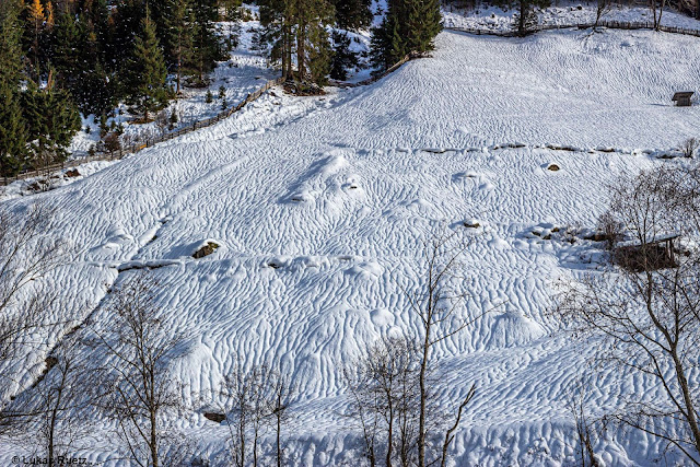
Impressive snow shapes generated by gliding snow. (photo: 25.11.2019)

Gliding snow waiting to unleash. Defereggental (photo: 22.11.2019)

Terrific launch of winter in the southern regions

Pictures, as we know, are worth more than 1000 words. There follow a few impressions of the current situation:

Awesome powder snow on the descent from Schöntalspitze in the Stubai Alps. (photo: 21.11.2019)

The joys of a Tux Alps descent in early winter. (photo: 21.11.2019)

Alone on the path to the Grossvenediger. (photo: 25.11.2019)

Outlook

The forecasts of the ZAMG Weather Service predict no significant changes in the avalanche situation.

Appendix to 29:11: Latest analysis by ZAMG Weather Service shows that in the furthermost western regions a cold front will bring as much as 50 cm of fresh snow from place to place (in general about 20 cm). In the regions where snowfall is heaviest, increased heed of freshly generated snowdrift accumulations in very steep terrain is required.


The snow is settling to an increasing degree, the snowpack is stabilising. Repeated bouts of precipitation, wind in some places. The coming days promise similar weather.

Message of the moment: enjoy the snow masses in the south!


Friday, 22 November 2019

Glide-snow avalanches are the main danger

Lots of snow in the south

Precipitation this last week has been unusual. The consequence: above average snow depths for this juncture of the season.

“A Winter Wonderland” at the Dolomiten Hut in the Lienz Dolomites. (Photo: 18.11.2019) 

At low and intermediate altitudes, massive rain impact on the snowpack. Stubai Alps (Photo: 20.11.2019)

The heavy snow burden caused much tree breakage and toppling. This danger is still a threat. In the photo: a recently toppled tree in southern East Tirol (Photo: 20.11.2019)

The snowfall was accompanied by storm-strength winds. Stubai Alps. (Photo: 18.11.2019)

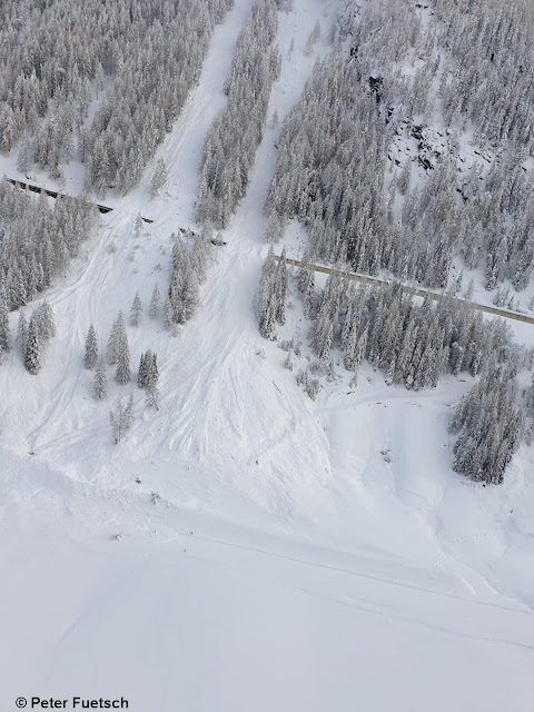
The combination of heavy snowfall, stormy winds and rising temperatures led to numerous avalanches, culminating on Sunday, 17.11.2019. In the photo, avalanches over the snow sheds on the Felbertauern Road (Photo: 18.11.2019)

Avalanche danger diminishing

During the last few days, avalanche dangers have decreased incrementally. In the interim, generally moderate danger prevails in the regions where precipitation was heaviest; in the northern regions, low danger.

Main peril: gliding snow

Most caution is still needed towards glide-snow slides and glide-snow avalanches on steep, smooth surfaces. Most of the threat is on grass-covered slopes. However, also below house roofs there is a hidden risk of gliding snow masses.

During the last few days in the regions of Tirol where precipitation was heaviest, numerous glide-snow avalanches have released. Glockner region (Photo: 21.11.2019)

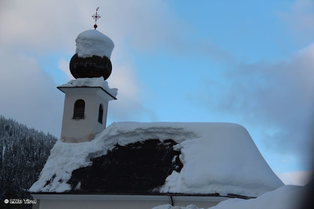
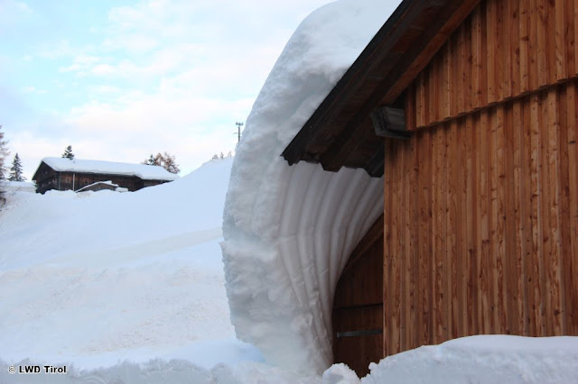
Snow masses gliding off a roof can endanger people. Southern East Tirol (Photo: 20.11.2019)

The snow glides...and malforms. Obertilliach (Photo: 20.11.2019)

The apogee of glide-snow avalanches has passed. Nevertheless, at very least where glide cracks have opened in the snowpack surface, snow can still glide away as a single mass. Therefore, we advise avoiding all spots below glide cracks in the snowpack. Caution is also urged on tours through narrow valley zones flanked by grass-covered slopes, including above the treeline (where the risk is not visible).

Snowpack layering is mostly stable. Caution esp. on shady, high-altitude slopes near ridgelines.

Our picture of current snowpack layering in the land is becoming ever sharper, thanks to explorations in outlying terrain and extremely good observer reports. Snowpack analysis results in the following:

The snow cover has settled increasingly over the last few days, and stabilized.
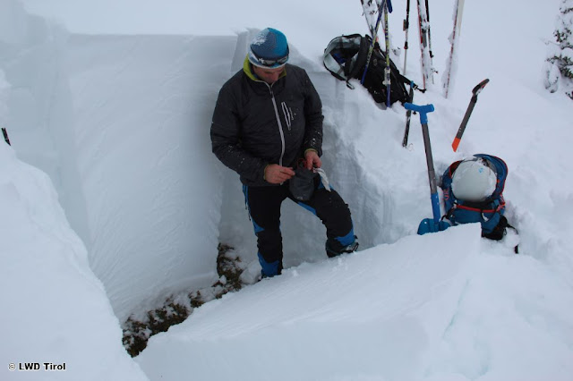
Snowpack analysis at 2100 m, NW in northern East Tirol. Compact snow cover without weak layers. (Photo: 21.11.2019)

Weak layers inside the snowpack are now found only at high altitudes, starting at about 2400 m. At those altitudes, it is important to distinguish between surface-level weak layers and ground-level weak layers.

Near to the surface there is powder, often wind-whipped. Due to the stronger winds at high altitude, these danger zones are ever more frequent. Caution urged esp. on very steep, shady slopes near ridgelines.
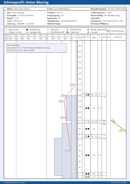
Snow profile below Hohe Bösring on the Carinthian Crest. Wind-impacted powder snow is the potentially weak layer. Here at 2310 m, only a partial fracture could be generated, a positive sign. But the likelihood of triggering tends to increase with ascending altitude.

Near the ground, particularly in glaciated terrain, there are potential weak layers, but in all likelihood these are no longer triggerable by skiers and freeriders.
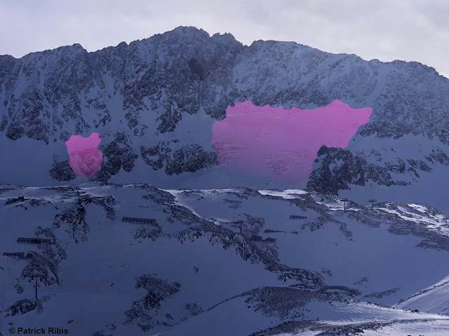
In high alpine, glaciated terrain along the Main Alpine Ridge from the Ötztal Alps eastwards, large slab avalanches were frequently observed. Some of them triggered naturally, like the one in the photo on Aperen Pfaff in the Stubai Alps; others were triggered artificially by explosives. (Photo: 20.11.2019)

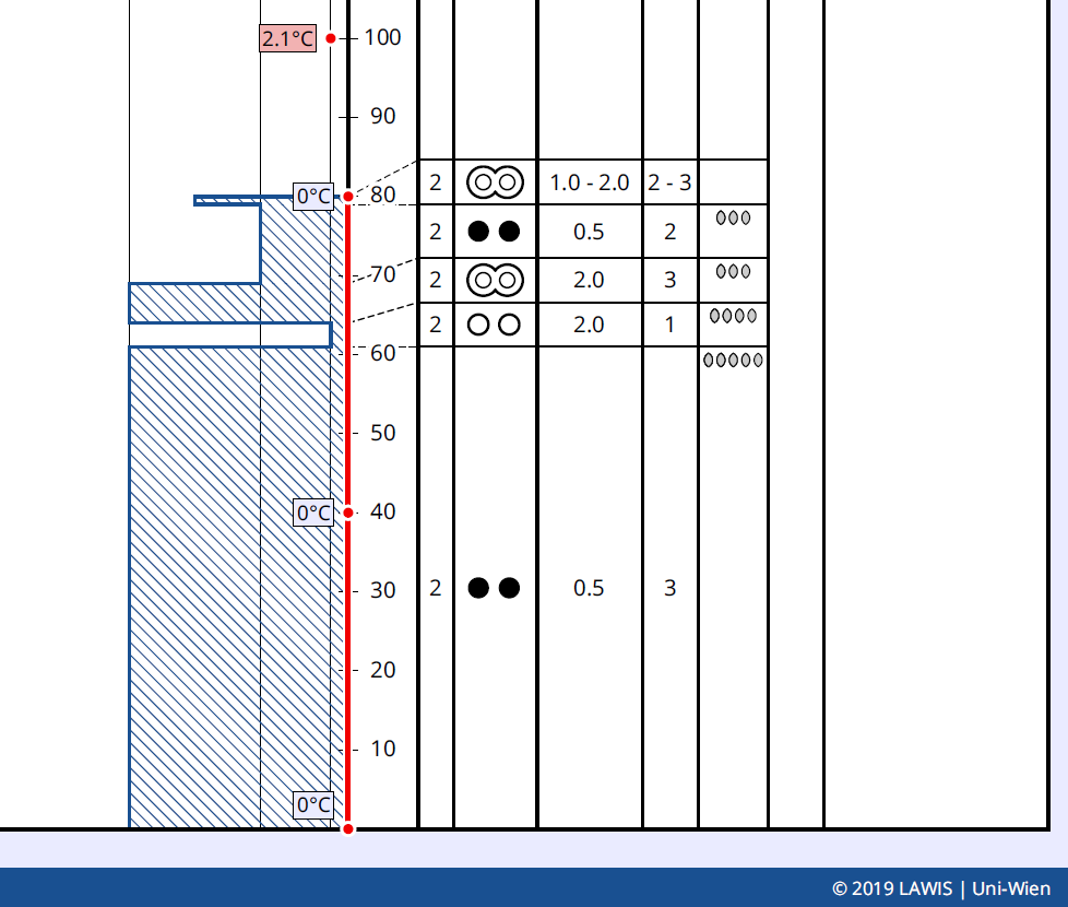
The decisive factor for gliding-snow activity is the moist snowpack at the ground, at least above 2500 m. At low and intermediate altitudes, the snowpack is mostly isotherm, i.e. thoroughly at 0 degrees C.
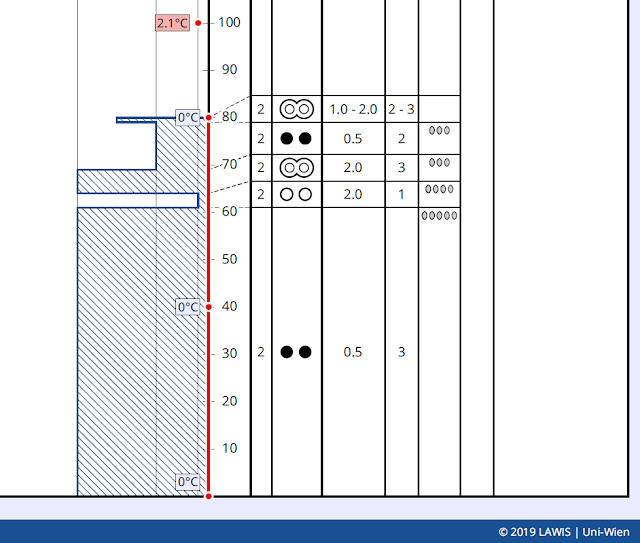
The red line shows the temperature range inside the snowpack: isotherm. Location: Kals, 1530 m, SE, 30 degrees.

Outlook

The forecast is for higher temperatures. Thus, the snow melting process can raise the frequency of glide-snow avalanches for a short time.

In the heights, trigger-sensitive snowdrift accumulations will be generated increasingly by strong and further intensifying SW winds. For trained skiers and freeriders, they will be easily recognizable and dangerous only for a brief spell.

All in all, quite favourable conditions prevail for skiers and freeriders, as long as one keeps an eye on the gliding snow problem.

Sunday, 17 November 2019

Heavy precipitation with strong winds and rising temperatures driving naturally triggered avalanches to a climax

High avalanche danger in southern regions

What the ZAMG Weather Service has dubbed an “extreme weather situation” is leading to an extraordinary avalanche scenario, with high avalanche danger in general in the southern regions.


Danger map of the Avalanche Bulletin for 17.11.2019

The combination of heavy snowfall including storm-strength winds in the heights, and rising temperatures complete with increasing rainfall at least up to intermediate altitudes, has weakened the snowpack to an extraordinary degree in the interim.

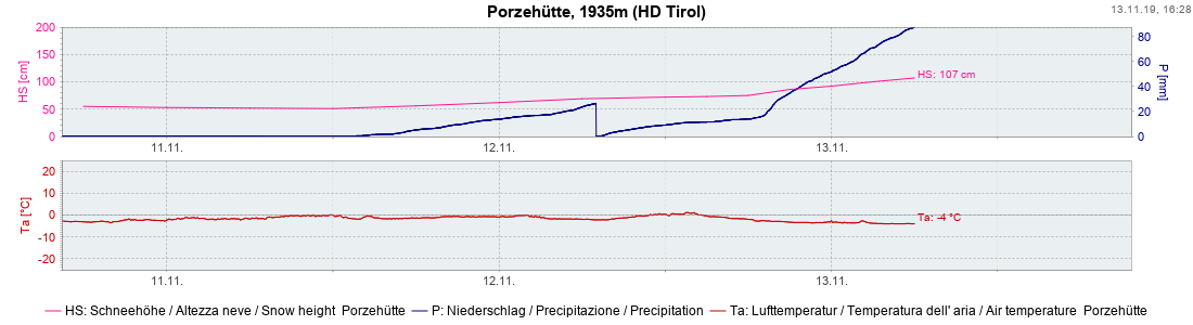
Three bouts of fresh snowfall since 12 November. What spiked the current critical avalanche situation was the persistent precipitation, the rising temperatures (snow surface temperature reaching 0 degrees on the measurement field) and the strong-velocity winds. Station in Defereggental

Heightened activity of naturally triggered avalanches

Naturally triggered avalanche releases are the result. At this juncture the first large-sized releases have been registered in northern East Tirol in Defereggental and Virgental (near the prudently made closures) and in Stubaital. Our colleagues in South Tirol and Trentino have also reported the first wet-snow avalanches, some of which were very large.

Avalanche release in Zillergrund (Photo: 17.11.2019)

This huge slab avalanche was artificially triggered by explosives on Rettenbachferner glacier yesterday, 16 November.

During the afternoon, we anticipate ongoing persistent intensive precipitation and, thus, more naturally triggered avalanche releases, some of which will be very large, particularly in higher altitude starting zones. In addition, there is also high danger of glide-snow avalanches on steep grass-covered slopes, particularly in the regions which are rain-impacted. Due to the water seepage into the snowpack, the friction of the snow with the ground is reduced. This increases the likelihood of release.

An important theme during the last few days: glide-snow avalanches on steep grassy slopes. Heightened danger will persist over the next few days. Sillian (Photo: 16.11.2019)
Apogee of precipitation is currently southern East Tirol, as forecast by the ZAMG Weather Service.

The steep curve of precipitation reflect very intense precipitation. Southern East Tirol.

What’s next?

The culmination of naturally triggered avalanche activity will be reached and passed today, 17 November. Due to the persistent strong winds at high altitudes (well above transport velocity) and the additional burden atop the snowpack which this will cause, together with heightened danger of glide-snow avalanches, the danger level will still (just) be “high” in the major areas of precipitation tomorrow (18 November).

Ongoing strong winds in the mountains

Glide-snow avalanches are the main danger. Slab avalanches from high-altitude starting zones are still expected only in heavily wind-impacted zones.

Forecast for Tuesday, 19 November, is still up in the air due to further, uncertain amounts of precipitation.

In the northern regions of the land, better conditions, due to much less precipitation.


Friday, 15 November 2019

Critical avalanche situation with naturally triggered avalanches in regions where snowfall heaviest. Start of daily avalanche forecasts 15 November at 5:00 pm for 16 November 2019


Today, 14.11, we took advantage of the window of good weather and focused on the snowpack layering, together with our team of observers. Simultaneously, Avalanche Commissions made their first exploratory flights in the regions where snowfall has been heaviest.

Snowpack analysis is the basis for correct assessments of danger. (Photo: 14.11.2019)


We currently face two serious problems which will become more threatening on Friday, 15.11, due to the massive southern barrier-cloud syndrome and two extraordinary bouts of precipitation.


On the one hand, there is an extremely pronounced gliding snow problem: the recently fallen snow glides away over steep, smooth surfaces. Numerous glide-snow avalanches have been reported over the last few days and have forced wide-ranging road closures in East Tirol, among other measures. Gliding snow is also a threat on steep house roofs. The danger of gliding snow avalanches will increase still further with the accumulating snow burden and with the increased moisture of the snowpack. For that reason, we appeal to everyone to take this danger very seriously, to respect all closures and avoid all spots below gliding snow cracks.

Gliding snow cracks and glide-snow avalanche in Defereggental. (Photo: 14.11.2019)

Glide-snow avalanches endanger roads in Defereggental.(Photo: 14.11.2019)


An additional danger stems from the pronounced fresh snow / snowdrift problem, particularly above the treeline. Today, 14.11, the wind – as predicted by the ZAMG Weather Service – intensified significantly. In the mountains, far-reaching snow plumes were observed. Snowdrift accumulations were freshly generated which in places are very prone to triggering. And to top it off, two very intensive bouts of precipitation are fast approaching: tomorrow on Friday, 15.11 in the regions along the Main Alpine Ridge from Vent Valley eastwards including East Tirol, 50-100 cm of fresh snow is expected; on Sunday, similar amounts again, accompanied by an ascending snowfall level. The danger of naturally triggered slab avalanches which in some cases could be very large is increasing steadily, particularly on leeward, very steep slopes. Avalanche danger in the regions where snowfall has been heaviest will be high tomorrow, 15.11. In other words, Danger Level 4!

Snow transport due to intensifying wind impact along the Main Alpine Ridge. Hochgurgl  (Photo: 14.11.2019)

Naturally triggered slab avalanche. Fresh snowdrifts on top of loose, cold powder snow. Hochgurgl  (Photo: 14.11.2019)

Situation similar to previous photo in the Stubai Alps (Photo: 14.11.2019) 

Starting tomorrow, 15.11.2019 we will start with our daily forecasts and report of avalanche dangers for the following day, every day at 5:00 pm. In addition, we publish information in this blog at least once weekly, every Thursday, about the current snow and avalanche situation.

Thursday, 14 November 2019

Deep winter conditions in parts of Tirol. Heed avalanche danger!


The precipitation which was forecast by the ZAMG Weather Service has arrived. In the regions along the Main Alpine Ridge from the southern Ötztal Alps eastwards and in East Tirol, 50 to 80 cm of fresh snow have frequently been registered. In southern East Tirol there was generally about 100 cm of fresh snow registered.

To date, most of the precipitation has fallen in southern East Tirol.

Hand in hand with the snowfall, avalanche danger has increased. The main peril occurs in the regions where snowfall has been heavy through gliding snow masses over steep, smooth surfaces. In general, these are steep grass-covered slopes.

Roads are threatened by gliding snow masses over steep grassy slopes. Sillian  (Photo: 13.11.2019).

Some roads were closed as a precaution. One small glide-snow avalanche covered the road into Obernbergtal on 13 November, but no one was buried.


Caution is also urged beneath steep house roofs, where snow masses can slide off and endanger persons.

Conditions like in deep winter, below Zettersfeld near Lienz in East Tirol  (Photo: 13.11.2019)
Lots of fresh fallen snow, also in rear Zillertal  (Photo: 13.11.2019)


Above the timberline in the regions where snowfall has been heaviest, caution is also urged towards fresh snowdrift accumulations in very steep terrain. Size and frequency of the snowdrift accumulations are expected to increase with the rising winds which will soon intensify. The snowdrift problem needs particular attentiveness from backcountry skiers and freeriders who intend to take advantage of the improved weather on 14 November for activities in outlying terrain.

Apart from potential avalanche dangers there are other problems in the form of power outages and falling trees.

Heavy snow burdens and toppling trees have caused damage to some power lines. Sillian. (Photo: 13.11.2019)

Snow burdens the trees in southern East Tirol (Photo: 13.11.2019)

What’s next: Weather conditions will improve onThursday, 13 November, the wind will shift from northerly to southerly and on Thursday night will reach storm strength. Once again, intensive snowfall with similar focal points is anticipated. The same thing applies to Sunday, 17 November: a third bout of precipitation in the selfsame southern air current is anticipated. Avalanche danger will continue to increase a further notch. The glide-snow problem will become more threatening. Slab avalanches will also become more likely.

On 14 November, the blog will be updated again.