Tuesday, 29 January 2019

Flexible warning-regions – why?

Some users who have consulted our cross-border avalanche bulletin over the last few weeks might have wondered why warning-regions in the Euregio are always changing their borderlines and sizes. Sometimes a region is small, enclosing only one mountain range; at other times the same region is far larger, covering all three regions of Tirol, South Tirol and Trentino.


In this blog, we want to cast a bit of light on this subject and clear up just why warning-regions are continually being altered. It will be seen that this actually heightens the value of the new Euregio Avalanche Bulletin in important ways.

Background

The objectives of this device in the Euregio Avalanche Bulletin were not just to enhance the cross-border character and multi-lingual accessibility. Far more, it was meant to raise the quality of previous warning bulletins of the three regions. The new avalanche forecast enables avalanche analysts to describe dangers in a specific area more precisely and more consistently.

In the past in Tirol, South Tirol and Trentino, various avalanche danger levels were assigned to individual regions, but the description of the dangers which prevailed and the snowpack layering were valid for the entire province. In the new avalanche bulletin, this had to change: varying danger situations from region to region need to be separated from each other, described and depicted separately, in order to provide a picture of the situation which was as precise and consistent as possible. In order to reflect the regional/spatial distinctions of the given avalanche situation as flexibly as possible, the borderlines need to be flexible and changeable. On the other hand, it is still necessary to retain easily grasped borderlines oriented to topographical borders such as mountain ranges, valleys, or national borders.

Ideally, the bulletin should cover clearly defined warning-regions which are as small as possible and which permit a precise message of avalanche danger and their variability over a limited area. This would prevent dangers in a given region from being ranked too high, or too low. The textual descriptions continue to be valid for the entire warning-region without specific distinctions made in the descriptions. A study by Frank Techel, avalanche forecaster and researcher of the WSL Institute for Snow and Avalanche Research at SLF in Davos from 2018 demonstrates that small regions improve the quality of avalanche forecasts.
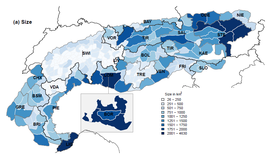

Warning-region sizes in the Alps. The darker the color, the bigger the warning-region. (©Frank Techel, 2018)

Until the end of winter season 2017/2018 the state of Tirol was sub-divided into 12 warning-regions; South Tirol into 11; Trentino into 21. While Trentino was already analyzing tiny regions with far smaller land surfaces in many cases, the warning-regions in South Tirol and Tirol were three times as large, on average.

Frequency and size of the tiny regions in South Tirol, Tirol and Trentino before and after the revamping to the new Avalanche Bulletin, starting with winter season 2018/2019:


State/ Province
Frequency
Size (min-max) [km²]

Season 17/18
Season 18/19
Season 17/18
Season 18/19
South Tirol
11
20
650 (180- 1110)
345 (105 - 1500)
Tirol
12
29
980 (380- 1920)
295 (115 - 1105 )
Trentino
21
21
290 (120- 540)
290 (120- 540)

In the process of developing the Euregio Avalanche Bulletin, it was agreed to restructure the warning-regions in Tirol and in South Tirol. The object was to create tiny regions which were distinct from their immediate neighbors particularly with regard to precipitation. These tiny regions, it was agreed by the European Avalanche Warning Services (EAWS), should not be less than 100 km².

Based on the daily registered precipitation in various winters and with the support of a computer algorithm, zones of similar precipitation amounts, so-called clusters, were arrived at, with which, together with the input of the avalanche forecasters, new regions were created: in South Tirol, 20 new tiny regions were created; in Tirol, 29. These also permit overall reportage based on the old warning-regions.


Results of the cluster analysis of winter 2011/12 (left) and 2014/15 (right) for Tirol and South Tirol with the 29 / 20 new tiny regions.

Avalanche warning

The avalanche forecasters in the Euregio South Tirol-Tirol-Trentino region now work with a multiplicity of tiny regions (70) which, depending on the given snow and avalanche danger situation, can be grouped together into larger warning-regions. During the course of the winter, the warning-regions are then re-grouped with areas where similar conditions and snowpack structure prevail. This provides a far clearer, more precise description of avalanche dangers. The experience of the last few weeks has shown that the overall Euregio region of 70 tiny regions was able to be grouped into 6-9 warning-regions on average.

Conclusion

This new approach to evaluating dangers permits avalanche forecasters to better communicate and describe the prevalent snow and avalanche situation, the threatening avalanche problems and the specific danger zones. We believe we have raised the quality of the avalanche forecast through this measure and we hope that readers see and understand, as well as gain benefits from the value of this enhanced value. It is a major adjustment, compared with the old avalanche bulletins and forecasts. Yet we are confident that readers will appreciate the clarity and precision of the new reports with time and be able to reap its many advantages.


Friday, 25 January 2019

Snow+wind after long period of cold will lead to increased avalanche danger

Current situation

Above average snow depths in far-reaching parts of Tirol for this juncture of the season.

Snow-depth map for Tirol, South Tirol and (not shown) Trentino. Decreasing depth curve towards the south.

Snow depths diminish steadily as the old snowpack consolidates. It is cold, winds are light. The extremely low surface temperature of the snowpack is a decisive factor for coming development.

Bitter cold in far-reaching parts of Tirol.

Low temperatures reinforce the metamorphosing of the snowpack surface. That means that the snow crystals become unbonded, typically forming faceted and decomposed snow crystals, also surface hoar. In addition, there is cloud cover resembling high fog in many parts of Tirol in which very light, fluffy powder snow - so-called ‘wild snow’ - is lodged.

On the snowpack surface there are loose, very cold snow crystals in far-reaching parts of Tirol.  (photo: 21.01.2019)

The “Nigg Effect” in ridgeline terrain in the Arlberg region.  (photo: 21.01.2019)

Huge surface hoar crystals in Gschnitztal just above a brook.  (photo: 24.01.2019)

Review

Regions of Tirol where snowfall was heavy have become a winter wonderland.

Glungezer in the Tux Alpen (photo: 18.01.2019)

Deep snow blankets alm huts in the lowlands.  (photo: 19.01.2019)

In addition, mostly low avalanche danger prevailed over the last few days in those regions where snowfall was heaviest. Many winter sports fans took advantage of favourable conditions to undertake steep ascents and descents.

Descent from Hochnissl (photo: 22.01.2019)

There was moderate danger at low and intermediate altitudes where snow has been heaviest because of the gliding-snow problem. Glide-snow avalanches did not release as frequently as during and just after the intensive snowfall, yet the risk of isolated, even very large glide-snow avalanches persisted.

Glide cracks on the Saile. View to the Inn Valley (photo: 20.01.2019)

Least favourable of all were conditions in the southern and central parts of East Tirol, where particularly on W/N/E facing slopes between 1800 and 2500 m an old-snow problem prevailed. The trigger sensitivity of the now older snowdrift accumulations has diminished due to low temperatures, but the danger has not passed.

Southern East Tirol:  little snow, trigger-sensitive snowpack  (photo: 20.01.2019)

Last week was marked by intensive snowpack analysis and stability tests. With the exception of the already mentioned old-snow problem in East Tirol, which was less risky in the regions of the central Stubai Alps, our stability tests showed a thoroughly favorable development inside the old snowpack.

Snowpack examinations conducted with the Alpine Police in the Zillertal Alps  (photo: 22.01.2019)

Snowpack examinations in the Venediger group with Peter Fuetsch, one of our observers  (photo: 19.01.2019)

Snow profile from rear Gschnitztal on 24.01.2019: persistent deep weak layers have bonded well with each other.

The development in the uppermost layers of the snowpack is rather different, however, as described above in the “Current situation” section. Furthermore, on steep south-facing slopes we observe in the upper layers at altitudes of 2200-2400 m an increasing expansive metamorphism beneath the thin melt-freeze crust (danger pattern 4 - cold on warm).

Outlook

The weather is about to become more turbulent. Tomorrow (25.01) winds will intensify, particularly in the south. In addition, starting on Saturday (26.01.2019) snowfall is anticipated in wide-ranging parts of Tirol.

Schneefall und Wind kündigen sich für die kommenden Tage an.

Danger pattern 5 “Snowfall after a longer period of cold” appears to be approaching rapidly. This is infamous as an accident ridden danger pattern: atop a wide-ranging loosely bonded, cold snowpack surface, snowdrifts are deposited.

In most parts of Tirol, there are wide-ranging snowpack surfaces of cold snow.

These snowdrift accumulations can be triggered very easily by minimum additional loading. Wherever there is snowfall, increasingly frequent (generally small-to-medium sized) naturally triggered avalanches can be expected. Avalanche danger will rise at least to considerable, also to high in those regions where snowfall is heavy. The major risk will then be borne by winter sports participants, who will in all likelihood trigger avalanches themselves.

For that reason, we advise avoiding freshly generated snowdrift accumulations without exception. Once again, backcountry skiing and freeriding tours demand much experience in assessing dangers on-site and a high degree of restraint. The situation in much-used freeriding terrain is measurably better, since the loose and even quality of the snowpack surface no longer exists.

Monday, 21 January 2019

Regional old-snow problem in southern territories. Fatal avalanche accident Laserztörl in Lienz Dolomites

Following the heavy snowfall, a favourable snowpack structure prevails in far-reaching parts of Tirol. Nevertheless, we face an old-snow problem in the Central Stubai Alps region of North Tirol and the East Tirol regions south of the Venediger range: the further south you go, the more striking it becomes.

This was demonstrated by wide-ranging snowpack analysis in recent days, also by avalanches in which persons were involved and naturally triggered avalanches.

The old-snow problem developed in these regions as a consequence of the shallowness of the snowpack, compared to other regions. Frequently, ground-level layers occur beneath a melt-freeze crust which consist of faceted, loosely-bonded crystals, plus some depth hoar. The “slab” which is the prerequisite for slab avalanches formed on top of that during the most recent round of snowfall, often under wind influence.

The melt-freeze crust formed during the period of higher temperatures and solar radiation in the longish phase without precipitation, then again during the period of rain around Christmas. Beneath that, faceted crystals were generated, especially during nocturnal periods of outgoing radiation, as was depth hoar. The melt-freeze crust enhances and amplifies wide-ranging fracture propagation once a weak layer has been triggered.

In foreground, a snow profile of the upper part of the snowpack reveals the mass of fresh snow, beneath that deposited between melt-freeze crusts, very loosely-bonded layers. Stability tests showed a high proneness to triggering. In background, avalanches triggered naturally due to the additional loading of recently accumulated snowdrift masses. Defereggen in East Tirol.  (photo: 19.01.2019)

We currently draw spatial limits around the old-snow problem: starting at about 1600 m up to at least 2400 m. The problem is more noticeable on W/SW to N to E/SE facing slopes and in flat south-facing terrain. Caution is urged especially at the borders of sparsely wooded zones.

As a result of this old-snow problem, a slab avalanche was triggered yesterday, 19.01.2019, below the Laserztörl in the Lienz Dolomites. A person ascending on a slope slightly more than 35 degrees steep was swept along and died as a consequence of the avalanche accident. A second person found some protection behind a large rock and was not injured.

Avalanche accident Laserztörl. The persons were on their ascent in the right part or the avalanche. Major fracture propagation resulted from a melt-freeze crust and weak layer of faceted crystals beneath it.  (photo: 20.01.2019)

Today, on 20.01.2019, we conducted our investigations together with the Alpine Police, using a state government helicopter. The slope faces NE to SE, mostly at an angle of 35 to 40 degrees steep. The fracture depth varies between about 30 cm and (in places near the ridgeline) about 100 cm. The length of the avalanche is estimated at just under 300 m.

A member of the Alpine Police below the Laserztörl in extremely steep terrain adjacent to the ridgeline. The greatest fracture depth was measured here, a result of wind impact. (photo: 20.01.2019)

View from the burial spot towards Laserztörl  (photo: 20.01.2019)

The state government helicopter just before landing. We also discovered the ascent track and the end of the avalanche wedge.  (photo: 20.01.2019)

Friday, 18 January 2019

Increasing calm in North Tirol. Old-snow problem esp. in central East Tirol. Caution: fresh snowdrifts!

Current situation

Avalanche danger has ongoingly decreased over the last few days. In the major areas of precipitation the snowpack has settled, fresh snow and drifts have bonded well with the old snow.

Enormous settling of the snowpack since precipitation came to an end on Tuesday, 15.01. The graph shows a modelled settling.

Also at Sonnbergalm measurement station in Sölden a noticeable settling of the snowpack can be observed.

The major danger in most parts of North Tirol and northern East Tirol stems from generally small-sized but trigger-sensitive snowdrift accumulations. They occur in all aspects, particularly adjacent to ridgelines. Avalanche prone locations tend to increase in frequency and size with ascending altitude. The older snowdrift accumulations which were generated during the last snowstorm (13-15 January) and were often deposited on top of the light, fluffy snow of 12 January are no longer likely to trigger as avalanches, at most on shady, wind-protected slopes, but more at high altitudes.

The situation in central East Tirol, on the other hand, north of the Drau and south of the Main Alpine Ridge is much more treacherous. The snowpack was relatively shallow after the snowfall early this week, the numerous weather fronts generally brought small amounts of snow. In some places there was rainfall up to above the timberline. Due to expansive metamorphism of the snow crystals, a weak old-snow fundament formed containing a sequence of melt-freeze crusts and loosely-bonded, faceted crystals. The 30 cm of fresh snow (more at high altitudes) from early this week was deposited on the old snowpack and have formed a so-called “slab” on the deeper-down weak layers. The weak old snow can be triggered even by minimum additional loading, and the avalanches can grow to large size. Even remote triggerings have been registered and continue to be possible. Avalanche prone locations are found in all aspects above about 1600 m. Caution is therefore necessary, due to the fresh snow and strong winds in the Lienz Dolomites. Even small snowdrifts can be dangerous.

Slab avalanche triggered by skiers on Gaishörndl in Innervillgraten. The avalanche fractured in the weak old snow.  (photo: 15.01.2019)

At the Mosesgipfel weather station in Innervillgraten the snowpack was quite shallow until the end of last week. Thus, huge temperature fluctuations inside the snowpack occurred which anhanced the formation of faceted crystals and weak layers.

Similarly deposited but less acute is the old-snow problem in the central Stubai Alps and the Gurgler group. Also there, the snowpack was shallow for a long time. Deeper down in the snowpack were faceted, weak layers near melt-freeze crusts which were triggerable. Due to heavy coverage with fresh snow, triggerings are generally possible only with large additional loading. Shallow-snow zones are particularly unfavourable, however: weak layers are often weaker and less well covered. Therefore, triggering is more likely (hotspot).


Snow profile from Unterrainsalm in Obernberg on 14.01.2019; west, 1555m, 32°. Weak layers in the old snow are easily triggered in places.  (© Esther Baum)

Review

Due to a strong NW airstream, new, intensive weather fronts were brought to the Alps between Saturday 12.01 and Tuesday 15.01 from the Atlantic. Accompanied by strong-to-stormy winds, there was heavy snowfall in Tirol. Even in the Dolomites there was up to 20 cm of fresh snow registered. Huge amounts of snow fell on the Seegrube above Innsbruck: between Sunday morning 13.01 and Tuesday morning 15.01 there was 215 cm of fresh snow registered.

Most snowfall was registered in the Allgäu and Lechtal Alps, Karwendel, Wilder Kaiser, Kitzbühel Alps and Hohe Tauern.

The precipitation was accompanied by strong-to-stormy NW winds.

The snowfall to date this year is historically unusual. At the southern portal to the Felbertauern there has never yet been such a deep snowpack since the beginning of measuring in 1990.

On Monday, 14.01, due to the huge amounts of snow, high intensity of precipitation and persistently strong winds, numerous large-to-very-large, in isolated cases even extremely large avalanches were expected. For that reaons, the highest danger level (5, very high) was assigned in western regions of North Tirol, in the Zillertal Alps, Venediger Group and in the Karwendel (see Blog).

Numerous reports as well as the results of exploratory flights over the mountains on Tuesday, 15.01, showed high avalanche activity. Many large and very large natural triggerings of slab avalanches were registered, particularly often in the Karwendel, Mieming Massif, Pitztal and Paznauntal. Also in Gschnitztal and in northern East Tirol, avalanches plummeted down to the valley floor. Some of them caused damage to forests, electric lines and building. No human casualties occurred. An important theme during this heavy snowfall was glide-snow avalanches, whose trigger-sensitivity was enhanced still further by rain impact up to 1500 m. Repeatedly, sectors of roads were displaced, also buildings were damaged.

It was only through the uninterrupted emergency service of many people on duty that the safety of the population could be ensured through this extraordinary period of bad weather.

High glide-snow activity in far-reaching parts of Tirol, e.g. here in the Wildschönau.  (photo: 14.01.2019)

Natural gliding of a glide-snow avalanche in Navis. Glide-snow avalanches can’t be artificially triggered. Therefore, safety authorities are often confronted with big problems.  (photo: 14.01.2019)

An avalanche in Aurach near Kitzbühel swept some forest along with it.  This was a glide-snow avalanche. (photo: 15.01.2019)

Glide-snow avalanches and fracture of a slab avalanche in Ausserfern.  (photo: 16.01.2019)

Glide-snow avalanches already covered by fresh snow, near Leermoos in Ammer range.  (photo: 15.01.2019)

Deposit of a huge slab avalanche below the Kleinen Zunig on the Felbertauern road between Huben and Matrei.  (photo: 16.01.2019)

An alm hut which suffered damages from a slab in Niltal near Virgen in East Tirol. In the background, the destroyed lift station at the Bonn-Matreier Refuge. (photo: 16.01.2019)

Large naturally triggered slab avalanche at the Bschlaber Kreuzspitze in the Lechtal Alps.  (photo: 15.01.2019)
Avalanche near Piösmes in Pitztal.  (photo: 16.01.2019) 

Fracture area of an artificially triggered slab avalanche above the glacier road to the Stubai Glacier ski area.  (photo: 2016.01.2019)

Fracture of a large naturally triggering slab avalanche on Hochwanner in the Mieming Massif. Many slab avalanches fractured near to ridgelines in very steep terrain.  (photo: 16.01.2019)

Snow fences support the snow masses and prevent avalanches from fracturing.  Paznauntal. (photo: 16.01.2019)

Rain at low altitudes left its marks on the snowpack.  (photo: 16.01.2019)

Outlook

On Thursday night (17.01) a cold front from the southwest will reach us and bring light snowfall and swiftly dropping temperatures. Most of the snow is anticipated in the Hohe Tauern and Zillertal Alps.

On Thursday night (17.01) we expect a small amount of snowfall throughout the land.

The weather over the coming few days will be a mixture of sunshine and clouds, with light to moderate winds. The fresh snowdrift accumulations generated by winds on 18.01 will be quite prone to triggering to start with (reports already in from the central Stubai Alps).

The greatest caution is currently urged in the regions with the most striking old-snow problem (central East Tirol, Lienz Dolomites, regions of the central Stubai Alps and Gurgler Group). We recommend a prudent route selection, maintaining distances between members of a group both during ascent and descent, and circumventing large slopes and wherever the snow is shallow. Particularly in East Tirol, there is heightened danger of remote triggering!


Monday, 14 January 2019

UPDATE: very high avalanche danger also in Glockturm, Karwendel, Zillertal Alps and Venediger ranges


In the Karwendel there was much more snowfall than expected. Our observations show 95 cm of fresh snow registered on the Seegrube above Innsbruck. Together with the storm-strength winds, the consequence is higher danger: “very high.” The same applies to the Glockturm range, Zillertal Alps and Venediger group: “very high” avalanche danger. We anticipate ongoing very large, in isolated cases extremely large, naturally triggered avalanches in the regions with that danger level. Particularly exposed buildings and exposed transportation routes can be at risk.

Update of Avalanche Bulletin for Monday, 14.01.2019

By tonight, an additional 50 cm of fresh snow will be added to this, especially in the Karwendel, northern Zillertal Alps and Hohe Tauern, but also in the Silvretta.

Huge amounts of fresh snow are also expected today, 14.01