Thursday, 20 December 2018

Increasing number of weak spots with rain and snow on the weekend - warm-thaw Christmas weather

Weather review

This last week has again been highly variable: sunshine, clouds, some precipitation. The extremely cold phase came to an end on 16.12, subsequent temperatures rose continually. Three phases of wind were observed: on 13.12 a strong southerly wind prevailed, on 16.12 winds shifted to westerly, on 19.12 winds again were southerly from region to region.

Weather station data from Plojen station / Planskopf in the Serfaus ski area

Danger situation

In the EUREGIO Tirol-South Tirol-Trentino, low and moderate avalanche danger levels prevailed over widespread areas. The main problem stemmed from freshly generated snowdrift accumulations (frequently adjacent to ridgelines) as well as gliding snow, also old snow from region to region.


Snow situation & snowpack

Tirol was draped in winter garb in many places. Nonetheless, the possibilities for backcountry tours continue to be very limited, at least at low and intermediate altitudes.

En route in the Stubai Alps. View into Senders Valley. Contact with stones cannot be ruled out... (photo: 18.12.2018)

Ski tracks near Jochberg in the Kitzbühel Alps. Grassy ground rises to meet the skiers. (photo: 15.12.2018)

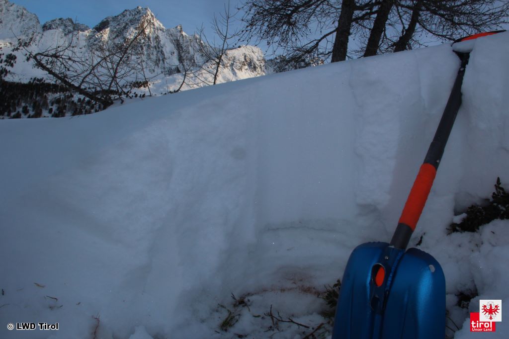
We utilised the week sharpening our picture of snowpack layering in Tirol a further notch. All in all, it looks good. Least favourable by comparison is the layering on shady slopes starting at about 2300 m up to maximum 2800 m, where there are weak layers of faceted crystals inside the snowpack increasingly frequently, surrounded by melt-freeze crusts. (The crusts became thinner and softer during the most recent cold phase.) Weak layers are generally not cohesive over wide areas, for that reason tend to occur mostly near bowls or in the vicinity of small concavities in the terrain. Glide cracks and settling noises (whumpf!) were not observed during this last week.

Sequence of crusts and faceted crystals. Stubai Alps. NW, 2300 m (photo: 18.12.2018)

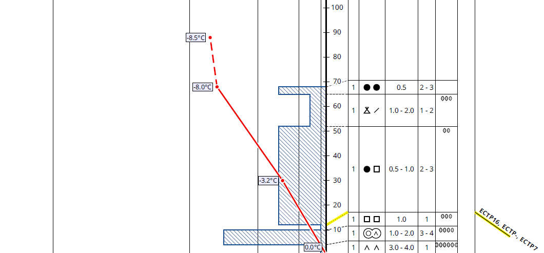
Weak layer of faceted crystals near ground-level on Predigberg in the Silvretta, N, 2100 m. (The old snowpack at this altitude is spatially limited, rarely cohesive or area-wide.) (photo: 18.12.2018) 

The structure of the snowpack surface is striking: during the most recent cold period, it became quite loose in wind-protected terrain. At least above the timberline there was frequent surface hoar evident, which then got covered in western regions of North Tirol. In isolated cases we received reports of Nigg Effect (surface hoar forming near ridgelines).

Surface hoar at the edge of the forested zone in the Kitzbüheler Alps (photo: 15.12.2018)

The wind impact referred to at the outset of the blog was also noticeable, particularly above the treeline. Increasingly frequently there are wind swirls evident, and thin melt-freeze crusts on sunny slopes in particular.

Wind ripples on the snowpack surface in the Silvretta (photo: 18.12.2018)

Avalanche activity

Last week, the report of a slab avalanche triggered by a skier in Fimbertal in the Silvretta arrived at headquarters in Tirol. Elsewhere it was rather quiet. However, activity involving glide-snow sluffs and glide-snow avalanches increased significantly on grassy slopes. The rise in temperatures reinforced this activity.


Photo left center, a freshly triggered glide-snow avalanche. Additional glide cracks and ‘wishbones’ bear witness to increased activity. Silvretta. (photo: 18.12.2018)

Glide-snow avalanches are a permanent threat in regions where there has been heavy snowfall. Hochfügen (photo: 13.12.2108) 

Outlook

Right on time for Christmas, warm-thaw weather announces its imminent arrival. It will soon become measurably milder. The precipitation will be rain at least up to intermediate altitudes. Winds will intensify and reach storm strength in some places.

The effect on the snowpack and avalanche danger levels is complex:
In regions exposed to rainfall, the snowpack surface will become moist, the loose layers of snow nearest to the surface will be destroyed. This is actually a positive development.

At higher altitudes, on the other hand, snowdrift accumulations will be generated afresh. Particularly where the drifts are deposited in very steep terrain which has been wind-protected to date, the proneness to triggering can be expected to increase. This trigger sensitivity will increase further as precipitation sets in and higher temperatures arrive.

In any case, the likelihood of glide-snow avalanches will increase significantly. Due to the higher temperatures and the rain, friction near ground level diminish, thereby raising the likelihood of releases.

Upshot: gliding snow on steep, grass-covered slopes and freshly generated snowdrift accumulations at high altitude will be the main danger.

Thursday, 13 December 2018

Trigger sensitive snowpack in places

Recent avalanches showcase a trigger-sensitive snowpack, at least in certain regions. Two dangers threaten currently:

- Fresh snowdrifts
- Trigger-sensitive old snowpack regionally
 
Freshly generated snowdrifts are always easily triggered when unbonded fresh snow is transported at low temperatures. Both coordinates are currently fulfilled. It is very cold. There were strong-velocity winds in the foehn lanes on 13.12. That is the moment when even minimum additional loading is sufficient to trigger the snowdrifts in steep terrain. (Powder and decomposed snow crystals form a weak layer. The latter form will incrementally bond with the drifted masses in the coming few days.) 

Particularly along the Main Alpine Ridge, huge snow transport was observed today. Zillertal Alps.(photo: 13.02.2018)


Avalanche accident below the Spannagel descent in Hintertux Glacier ski area on 13.12.2018. The north-facing slope is very steep at 2500 m. Immediately prior to the avalanche, strong winds transported lots of snow onto this slope. Snowpack analysis carried out today, 13.12, showed that the fresh snowdrifts were prone to triggering. The primary weak layer was powder snow covered with fresh snow. (Secondarily, the layers of faceted snow crystals referred to above surely fractured from place to place.) The avalanche is about 100 m long and 200 m wide.

The police helicopter transports the dog guide down to the valley after the accident (photo: 13.12.2018)

Weak layers more deeply embedded inside the snowpack are currently a risk, particularly in the regions along the Main Alpine Ridge between about 2300 and 2900 m, especially on shady slopes. In the vicinity of (rain)crusts there are frequently loose, faceted snow crystals. These weak layers are not evident area-wide as a rule.

Small-scale, covered, naturally triggered slab avalanches in the Stubai Alps at about 2400 m (center of photo) indicate heightened trigger-sensitivity of the snowpack (photo: 12.12.2018)

Below the Pfaffenbichl, a slab was released while there were people on the descent. The fracture was located at 2300 m on an extremely steep north-facing slope. The fracture depth varied between 20 cm and 160 cm. Snowdrift accumulations from the weekend deposited atop faceted weak layers were triggered.

Avalanche accident from 12.12.2018 below the Pfaffenbichl (photo: 13.12.2018)

View from upper zone of the avalanche fracture towards avalanche deposit. Pfaffenbichl  (photo: 13.12.2018)

Snow profile of the upper avalanche can be viewed - as usual - here.

Also atop faceted snow crystals, this slab triggered in outlying terrain in the ski area Silvretta Skiarena in Ischgl when someone descended over it. Altitude: 2300 m, west, very steep (photo: 12.12.2018)

There is also positive news: 

Apart from the Main Alpine Ridge, older snowdrift accumulations have consolidated well in general. The main problem there currently: the predominantly small-sized, fresh snowdrift accumulations which are frequently found in shady terrain adjacent to ridgelines.

Predominantly good conditions on the Arlberg (photo: 13.12.2018)

Wherever snowfall has been heavy, we observe increasingly frequent glide-snow releases. These avalanches are usually small-sized, sometimes medium-sized.

Numerous glide-snow releases in Lechtal  (photo: 13.12.2018)

Glide cracks indicate potential threats. We recommend avoiding all spots below such cracks. (photo: 12.12.2018)

Outlook for the weekend: 

The strong winds today (13.12) are expected to taper off during the night tonight. Next to no further snowdrift accumulation is anticipated. However, the snowdrift accumulations which formed today are expected to remain prone to triggering for several days due to the low temperatures. The old snow problem which occurs regionally between about 2300 and 2900 m in the above-mentioned regions seems to be the major problem. Weather change is expected on Sunday, 16.12.
(What we need to keep an eye on: Danger Pattern 4 (cold on warm) particularly on sun-bathed slopes far removed from the regions where there has been the most snowfall.)

Tuesday, 11 December 2018

Restraint imperative after onset of winter


Winter has arrived in Tirol. Since Saturday, 8.12.2018, more than 100 cm of fresh snow has been registered at high altitudes.

Enormous amounts of fresh snow in far-reaching parts of Tirol

Review
On Friday 7.12 in far-reaching parts of Tirol, an intermediate high generated very pleasant weather conditions and mild temperatures. The zero-degree level during the day was at nearly 3000 m. The snow situation in widespread areas of Tirol was still rather meagre at that juncture. The snowpack, where there was one, was heavily wind-impacted and erratic.

Not much snow, and the snowpack prior to the snowfall was highly irregular, as here in the central Stubai Alps On the windblown ridges, the Sahara sand from the end of October comes to light (photo: 7.12.2018)

On Friday night and during the early morning hours of Saturday (8.12) a severe cold front moved in from the northwest, temperatures dropped abruptly (about 10° within the shortest imaginable time). Accompanied by storm-strength winds there was 5-10 cm of snowfall registered, the snowfall level at around 1000 m. Intensive graupel was also observed.

Lots of graupel has been observed over the last few days, Inn Valley (photo: 10.12.2018)


Snow profile in the Grieskogel group from 8.12.2018; NE, 2580 m, 26°. Beneath a thin layer of snowdrift, the graupel which fell on Friday night, 8.12 is recognizable. On a north-facing slope above 2400 m, weak, trigger-sensitive layers are evident in the old snowpack. (© Lukas Ruetz).

After a warm front brought some relief and only a touch of precipitation on 8.12, another cold front reached us on Saturday night in another storm-riddled NW airstream. The snowfall level descended down to the valley floor.

In North Tirol and the Hohe Tauern, 40-100 cm of fresh snow was registered at high altitudes, from place to place even more. Most was in typical NW barrier-cloud regions of the Silvretta and Samnaun groups over the Verwall group and Allgäu Alps into the Karwendel, as well as in the Wilden Kaiser. In the Deferegger Alps it snowed far less, about 10-20 cm; in the Lienz Dolomites, hardly at all.

Recent weather developments can be precisely observed in the automated measurements at the Pischgraben/Madleinkopf station in the western Verwall group. On Friday night (8.12) a cold front moves through, temperatures drop abruptly by more than 10° C and wind velocity soars. The weak warm front subsequently brings short relief before a new cold front makes temperatures plummet once again. Since the beginning of this period of precipitation, approximately 100 cm of fresh snow was registered at this measurement station. Winds blew constantly at strong to storm strength from the northwest.
In central Oetztal at 1400 m on Monday 10.12, about 35 cm of fresh snow was registered, about 50 cm at the treeline (photo: 10.12.2018).

Wintery landscape also in the Zillertal (photo: 10.12.2018).

As a consequence of the strong to storm-strength winds, wide-ranging snowdrift accumulations were generated above the treeline.

Wind as the architect of avalanches is here transporting the fresh snow, Tux Alps (photo: 08.12.2018)

Potential weak layers for slab avalanches can usually be found inside the fresh snow mass in the form of cold fresh snow or graupel. Naturally triggered avalanches reported during this period of precipitation presumably fractured in these weak layers.

Inside the old snowpack are weak layers on shady slopes between about 2400 and 2900 m. These consist of faceted snow crystals embedded between crusts. Stability tests have shown highly varied fracture tendencies, from high to low fracture propagation.

One also finds in high alpine, glaciated, shady terrain still expansively mettamorphosed snow crystals right on the glacial ice. This layer can probably trigger only in exceptional cases due to the compacted snow layer on it which goes back to the end of October.


Snow profile in the central Stubai Alps; N, 2615 m, 25°. On shady north-facing slopes a sequence of crusts and unbonded layers is often evident. Even though the snowpack prior to the recent precipitation was extremely irregular, slab avalanches fracturing in the old snowpack cannot be ruled out. (© LWD Tirol).

Outlook
As weather conditions improve from the west, the wind will also recede. Snowdrift accumulations are covered in some places, making them difficult to recognize. Since the prevailing low temperatures will persist, it will presumably take a few days for the drifted masses to bond well with the weakened layers inside the fresh snow masses. Thus, we advise a high degree of restraint in very steep terrain. Caution: the first period of beautiful weather following a period of storm-ridden snowfall is always prone to accidents.

Throughout Tirol, it was shiveringly cold on Tuesday morning (11.12). These low temperatures are expected to persist over the coming few days. They will hinder a rapid consolidation of the snowpack.

Otherwise needful of heed: on steep, grass-covered slopes the fresh snow can glide. Zones below glide cracks should be avoided whenever possible.

Also technical snow can be swept away as a glide-snow avalanche, as here in the Hochimst ski area. In the interim, this area is cloacked in deepest winter (photo: 05.12.2018).

Friday, 7 December 2018

Isolated danger spots: small, easily recognized snowdrifts

Isolated danger spots: small, easily recognized snowdrifts
 
For backcountry skiing and freeriding tours, in most parts of the countryside 
there is still not enough snow. Only along the Main Alpine Ridge are we receiving reports of high-altitude, mostly shady slopes where conditions are acceptable.

Wintery conditions on shady slopes at high altitude as above, south of the Venediger Group. (Photo: 28.11.2018) 

Far less snow on south-facing slopes (Photo: 28.11.2018) 


Powder snow good enough for skiing is found on shady slopes at high altitudes, and practically nowhere else. Most often it was deposited on top of an old snowpack capable of bearing loads stemming from the last rounds of snowfall, e.g. 19.11, 23+24/11 and 27/11.2018.

Precipitation and development of snow depths last week in Kühtai.


The snowfall on 27.11 was to a greater extent in North Tirol, on 23.11 more in South Tirol.


Powder snow in the vicinity of the Stubai Glacier (Photo: 28.11.2018) 


Powder snow deep in the Ötztal (Photo: 28.11.2018) 


View towards Galzig, Arlberg region, before the snowfall of 27.11 (Photo: 26.11.2018) 


View towards Galzig, Arlberg region, following snowfall of 27.11 (Photo: 28.11.2018) 


View towards Galzig, Arlberg region: rising temperatures plus solar radiation amplify snowmelt (Photo: 29.11.2018) 

As the weather fronts passed through, winds from varying directions prevailed, sometimes blowing at strong velocity.

 A wind-exposed spot: the Patscherkofel, south of Innsbruck. Initially, southerly winds prevailed, shifting to northerly on 26.11 as temperatures dropped. Then another shift to southerly.

Small, rather isolated snowdrifts accumulated at high altitude, some of which can be triggered (on steep, shady slopes). With experience, these drifts can be easily recognized and circumvented.

Studying the snowpack a bit more closely, the words from the last blog still apply: weak layers exist, it is currently possible but unlikely that they will unleash.


A sequence of crusts and unbonded layers near the upper surface is currently not a problem, but we have to keep an eye on it. Stubai Glacier. (Photo: 28.11.2018) 

Thus, in the regions with ample snow, favourable conditions still prevail. The danger from rocks and stones is more threatening than from avalanches. Otherwise worthy of mention: last week was used for technical snow production.

Snow cannons full throttle in Kühtai. Skiing operations will be launched this weekend. (Photo: 28.11.2018) 

Thursday, 6 December 2018

After a roller-coaster week, winter draws nearer

After a roller-coaster week, winter draws nearer

Highly variable conditions have prevailed during the last week. Repeated bouts of rainfall or snowfall occurred The snowfall level lay between 2000 and 2800 m. At high altitude, the winds intensified measurably, blowing from westerly directions.

Example of variable weather conditions at the Nachtweide-Palinkopf station (Silvretta Group)


Alternating sunshine and clouds on the Grossglockner

Most of the snow fell in the western regions, e.g. here in the vicinity of Nauders (Photo: 03.12.2018)


Wind map of 04.12.2018; winds were blowing predominantly from the west


The high-altitude powder snow referred to in the last blog became a rarity as a consequence of the wind. The snowpack surface turned erratic, and the frequency of snowdrift accumulations increased incrementally. These snowdrift accumulations were generally small-sized, but in isolated cases could be triggered by large additional loading.

A skier triggered a small mass of drifted snow on the Stubai Glacier The weak layer was the covered powder snow. (Photo: 03.12.2018)

A heavily wind-impacted snowpack surface on the Rettenbachferner glacier (Photo: 05.12.2018)


The current situation in North and East Tirol permits backcountry skiing tours only to a very limited degree. Most of the snow which has fallen was deposited on the Main Alpine Ridge between the Ötztal Alps and the Hohe Tauern. A cohesive area-wide snowpack is evident predominantly above approximately 2200 to 2400 m. In the remaining parts of the land, there is still not enough snow for skiing tours in outlying terrain away from secured and marked ski runs.

The snow situation along the Main Alpine Ridge above approximately 2200 to 2400 m is quite good...

...but away from the Main Alpine Ridge there is still only a little snow, like here in East Tirol (Photo: 04.12.2018)

Particularly where as a consequence of the intensive precipitation at the end of October there was a large amount of snowfall, a solid snowpack base is evident. Crusts and unbonded weak layers are found only near the upper surface, by and large. Whereas in other regions the snowpack is often unfavourably layered due to the shallow snow and the faceted snow crystals generated by expansive metamorphosis, leading to pronounced weak layers.


Snow profile Vordere Schwenzerspitz in the Gurgler Group from 05.12.2018; west, 2800m, 30°. A compact snow base with a few crusts in the upper part of the snowpack. All in all, a very solid structure for future loading in the form of fresh snow (© Nicolas Metz).


Snow profile on Hoarberger Kar in the eastern Tux Alps from 02.12.2018; north, 2400m, 30°. A snow profile distinguished by ongoing switches of warm and cold: the crusts were formed through the impact of high temperatures and rain. During clear, cold days and nights, the expansive metamorphosis generated weak layers at ground level between the crusts. To date, a relevant amount of snow is still lacking to form a “slab” for the triggering of a slab avalanche. (© Florian Wechselberger).


What happens next?
On Friday night, a cold front will reach us from the northwest which will be accompanied by storm-strength winds and bring the first snowfall. The snowfall level will drop to nearly 1000 m. In the following days, snowfall over widespread areas will spread throughout Tirol, with steadily dropping snowfall levels. The major area of precipitation will be in the typical northern barrier zones. In East Tirol, especially in the southern parts, significantly less snowfall is anticipated.
As a result of snowfall and wind, the avalanche danger levels will increase over widespread areas.


Fresh snow forecast until Tuesday morning, 11 December