Avalanche reports from Tirol headquarters
Since yesterday, 29 December, headquarters has received information about 8 avalanches involving persons:
29.12.2020: Juifenalm (northern Stubai Alps); Rosskopf (eastern Tux Alps); Angerbergkopf (northern Stubai Alps)
30.12.2020: Kleiner Leppleskofel (east. Defereggen mountains); Grosser Leppleskofel (east. Defereggen mountains); Rogötzllenke (east. Defereggen mountains); Muttenjoch (central Stubai Alps); Schönbergspitze (east. Defereggen mountains)
All these avalanches unleashed without injuries. According to latest information they were medium-sized slab avalanches, focal point in the Defereggen mountains
 |
| Violet dots: large area of avalanches in Defereggen mountains on 30 December |
Continuing: serious avalanche situation, particularly in southern regions
We have reduced the danger level for tomorrow (New Year’s Eve) from high to considerable, but in the southern regions we anticipate a delicate situation for skiers. Particularly where surface hoar is blanketed by snowdrifts, the drifted masses can be easily triggered by minimum additional loading. Today we received reports of settling noises, fracture cracks and remote triggerings, whereas naturally triggered avalanches were not observed. Quite fitting for these observations are two photos of an exemplary route selection and behavior adapted to the present situation.
 |
| Tour in flat to moderately-steep terrain near Golzentipp (Carnic Ridge) - (photo: 30.12.2020) |
 |
| Arrow: a backcountry skier ends his tour at this point, before it gets steeper. Hoher Bösring - Carnic Ridge (photo: 30.12.2020) |
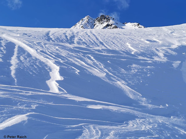
Further north, caution urged towards fresh drifts, also towards trigger-sensitive old snow
 |
| Wind sculpture generated by intensive wind force. Ötztal Alps (photo: 29.12.2020) |
Hard slabs
 |
| Snow lumps point to hardened slabs, Nauders mountains (photo: Hans Hofer, passed on by Florian Maas) |